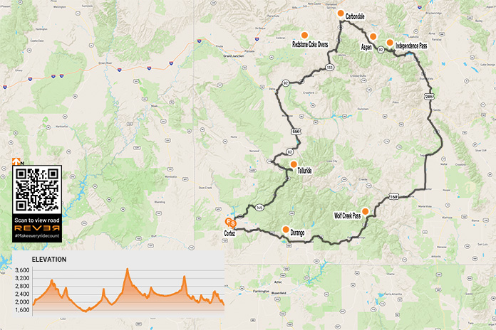
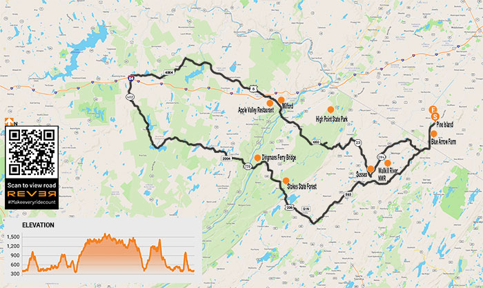
Rugged mountains, evergreen spires, historic towns, and fantastic curves highlight this loop ride through western Colorado.
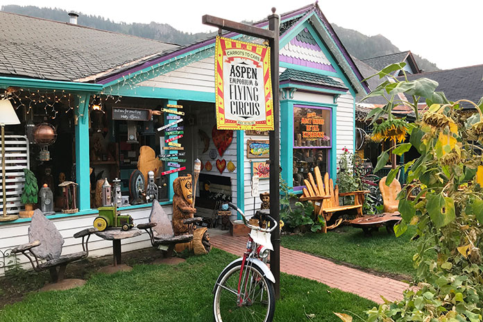
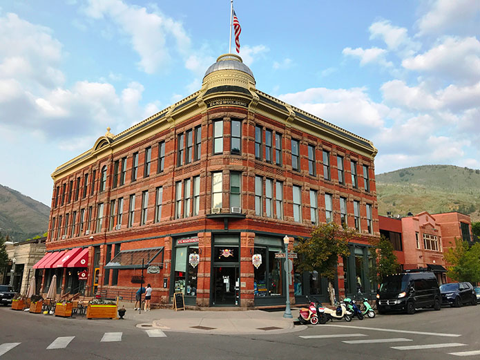
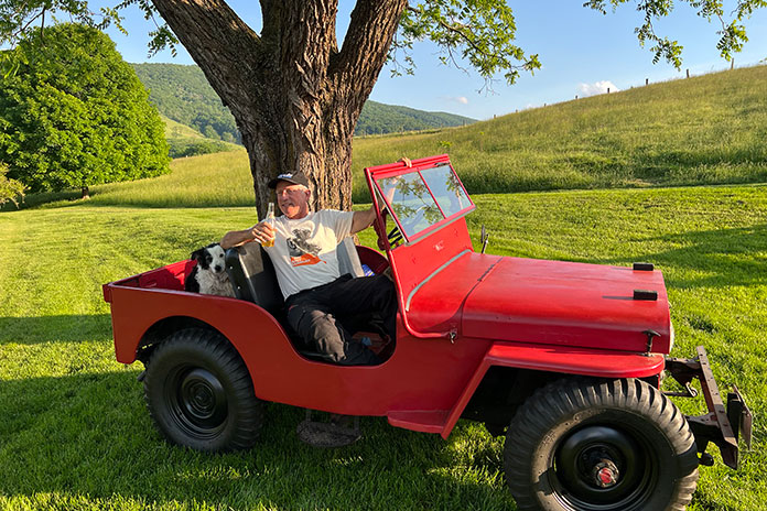
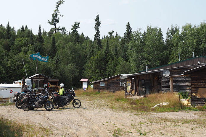
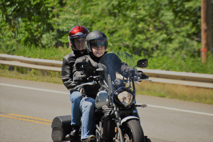
As I sat in the grassy courtyard of the Retro Motel in Cortez, Colorado, the quaint motel’s name struck a chord. It dawned on me that “retro” may be the theme of this western Colorado motorcycle ride. Merriam-Webster defines “retro” as something “fashionably nostalgic.” That seemed fitting as I contemplated a loop ride that would take me deep into the Rocky Mountains and through some of western Colorado’s iconic towns. The most famous of these towns are deeply rooted in frontier history but have since taken on the upscale air of ski-chic and Western high fashion.
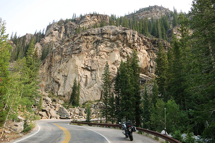
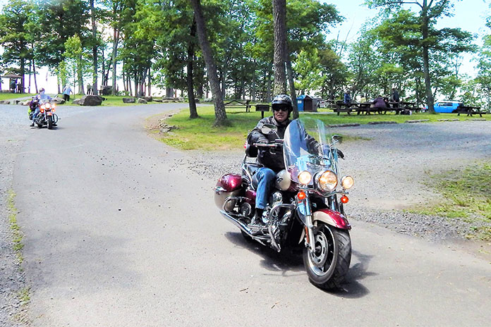
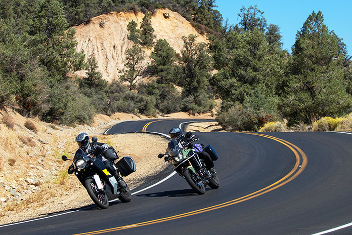
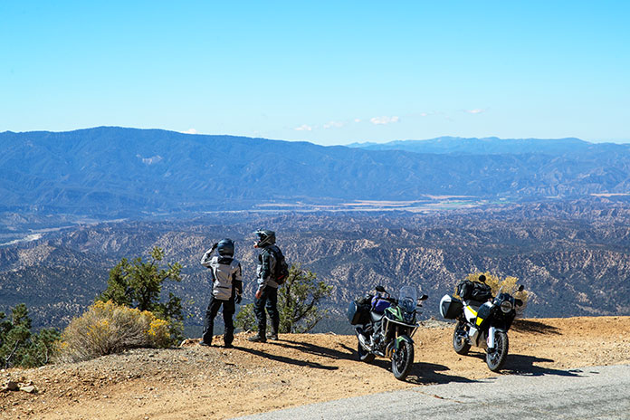
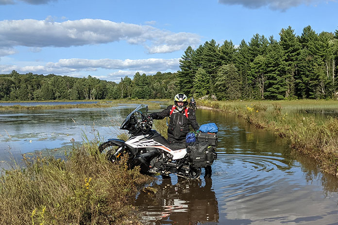
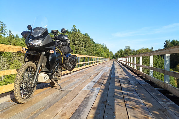
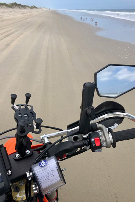
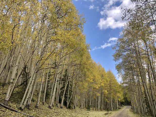
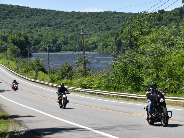
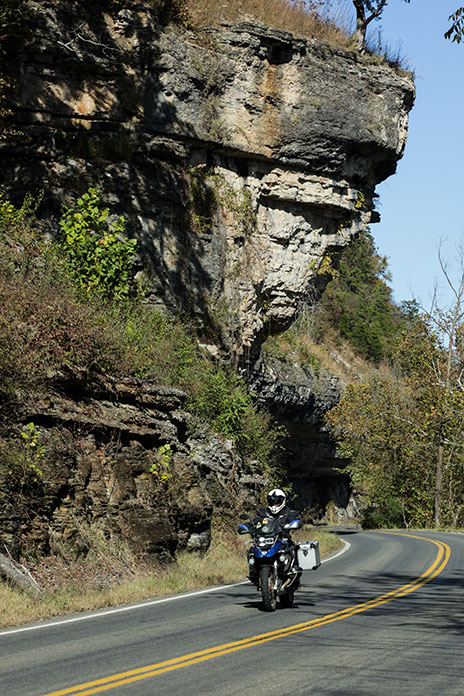
After a slug of coffee and a nibble of the motel’s grab-n-go breakfast, I headed north out of Cortez on State Route 145. In no time, I was rolling through the tiny town of Dolores. From there, I began a beautiful ride that follows the Dolores River for a long stretch and gains elevation. The route is a pleasant mix of short straights and sweeping corners.
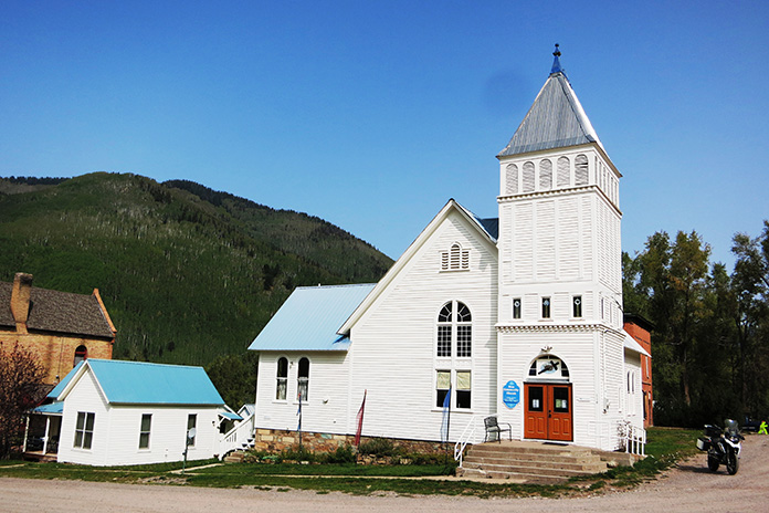
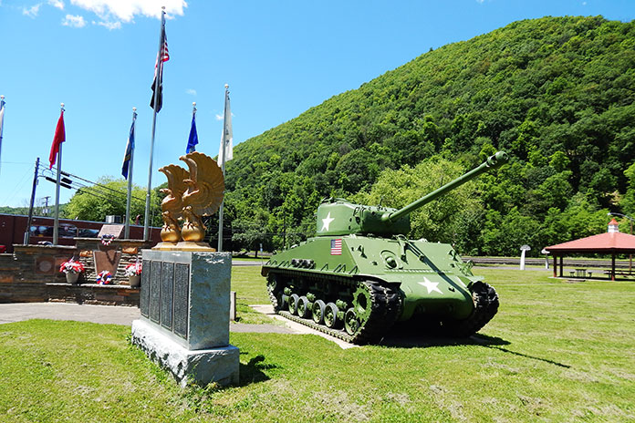
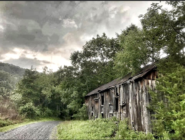
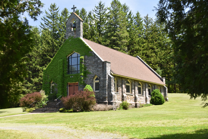
As I parted ways with the clear waters of the Dolores, the corners tightened and the air cooled. After a spirited ride, I motored into the historic silver mining town of Rico, which was settled in 1879 and still boasts impressive historic structures for such a tiny place. I dropped a kickstand at the town hall and the community church, both of which were constructed in the early 1890s and are remarkably well-preserved.
The whitewashed Rico Community Church was built in 1891 and restored in 1993.
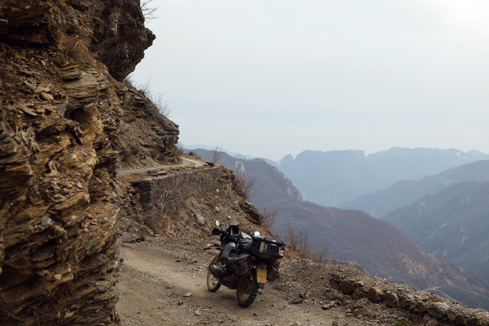
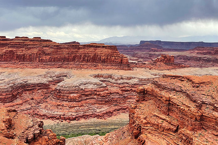
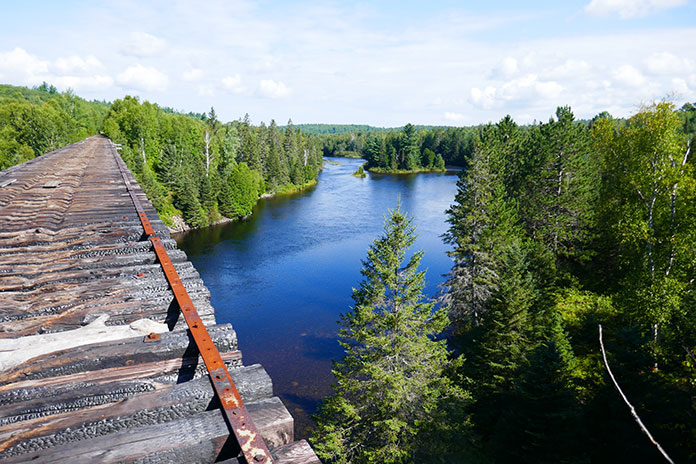
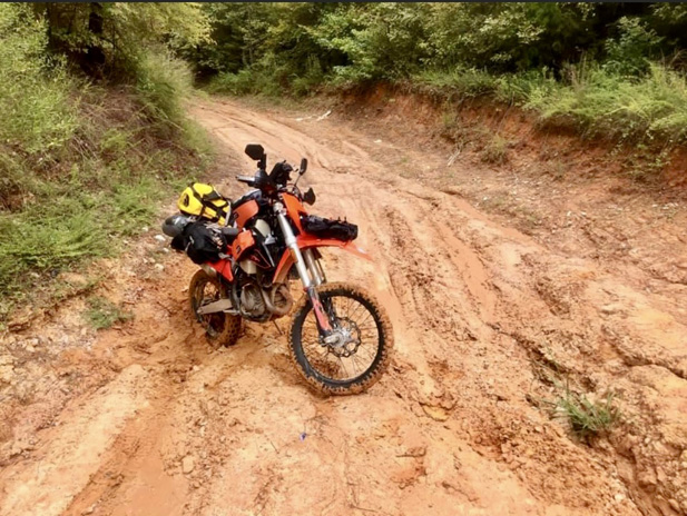
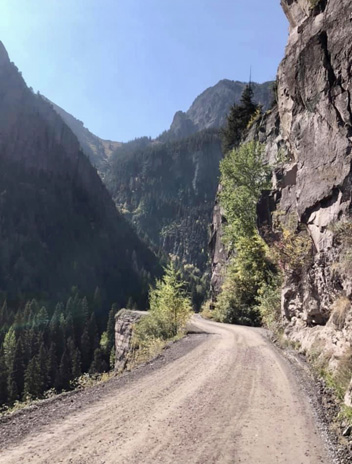
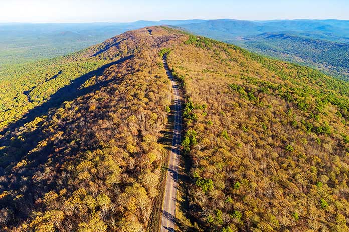
I had gained almost 3,000 feet in elevation in the 50-mile ride from Cortez, and the mid-September leaves were changing on the winding road out of Rico. The road coiled even more as I rolled through the vibrant greens of the western Rockies.
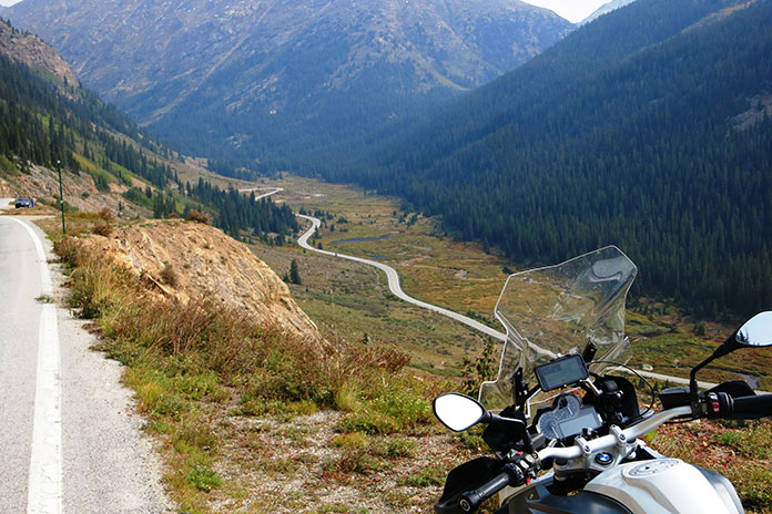
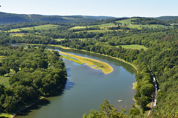
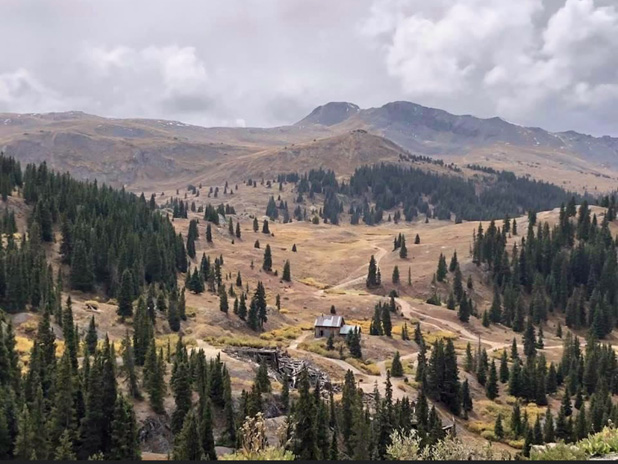
Overlooks in the Rockies often reveal the great tarmac that is to come.
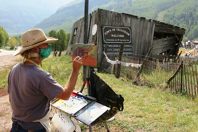
This isn’t the first time I’ve been in this area, and memories occupied my thoughts as I made the short jaunt into Telluride. The Victorian silver mining town, which sits in an impressive box canyon, was founded around the same time as Rico. The area’s economy has shifted from mining to skiing and tourism. Telluride is now distinctively upscale while retaining its Victorian charm. I rode past high-end boutiques peddling their pricey wares from within historic brick facades.
A painter practices his art on the outskirts of Telluride.
My reminiscing hit full tilt as I made it to Telluride Town Park, where my wife and I attended the Ride Music Festival a couple of years back. The setting is amazing, with a precipitous tree-covered mountain face as a backdrop behind the permanent concert stage. All the town’s festivals are held in this must-attend venue for music lovers. One of my favorite festival memories was listening to Pearl Jam fill the box canyon with their soaring melodic riffs. On my most recent visit, Frisbees and softballs filled the air, but I could almost hear Eddie Vedder still echoing in the evergreens.
I climbed out of Telluride to the northwest. It was good to be out of the congestion and back on the curvaceous tarmac of western Colorado. The traffic picked back up as I approached the city of Delta. After making it though the slow-and-go, I headed northeast toward Aspen.
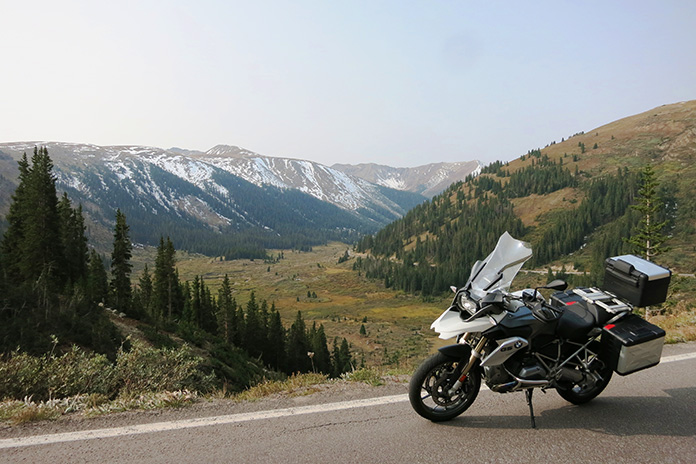
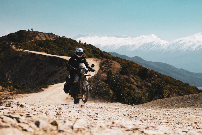
Snow-laced mountain passes are ubiquitous in the Rockies of Colorado.
This stretch is mountain motorcycling at its best. Tight curves and relaxed sweepers are the rule here, and the Rockies, which were snow-laced at the time, make the perfect backdrop. The road’s condition was remarkably good considering the weather extremes in this area. I had to slalom around the occasional pothole, but that is about it.
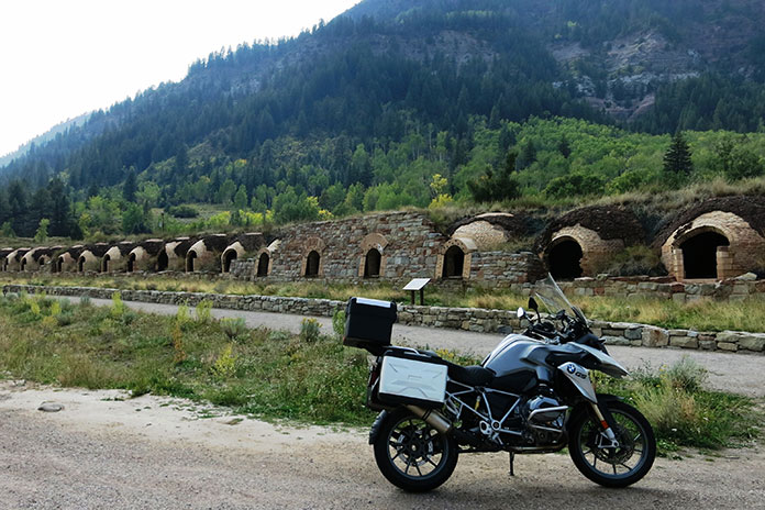
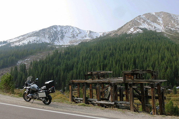
It was on this leg that I happened upon one of those “happy surprises” on a motorcycle tour. From a distance, I saw what looked like rows of mud nests made by cliff swallows – except much bigger. As I got closer, it was clear the structures were man-made and much more uniform. It turns out I was riding alongside the historic Redstone coke ovens. These brick-lined ovens were built in 1899 and were used to burn the impurities out of coal to produce “coke” for use in steel production. Fascinating stuff.
The Redstone coke ovens are a fascinating roadside attraction. Built in 1899, the brick-lined ovens were used to burn the impurities out of coal to produce “coke” for use in steel production.
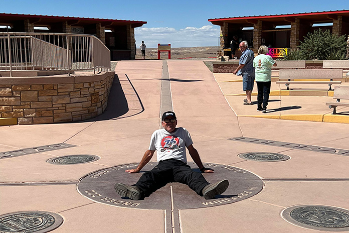
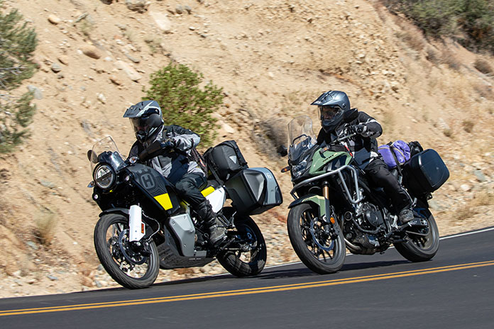
Western Colorado Motorcycle Ride? Or High Plains Drifting?
I gassed up in Carbondale, which is the northernmost point on this loop ride, and then headed southeast on State Route 82. The road here was not what I had expected. Most of this stretch heading to Aspen opens up into what you might expect on the high plains of Wyoming. There are amazing views, as much of the area is wide open or lined with only intermittent lower vegetation. It was a relaxed and entertaining stretch on this last portion of the day’s riding.
As I rolled into Aspen, I couldn’t help but think of that ridiculous scene from the movie Dumb and Dumber when Jim Carrey and Jeff Daniels are nearly frozen solid when they ride into town. Thankfully, I was not on a minibike, and my gear was much more appropriate.
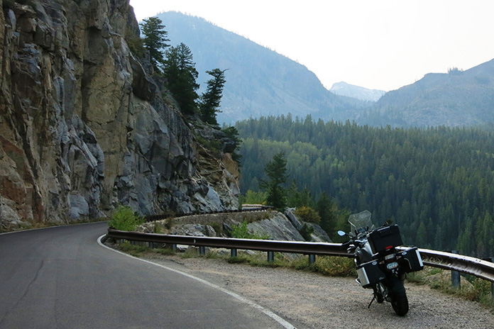
Local wildfires had cast a hazy pall over the otherwise idyllic landscape.
Aspen is a ski, shopping, and outdoor recreation mecca in the Rockies. Ski slopes lead from the surrounding mountains and seemingly terminate directly on the town’s main street, which is lined with stately buildings dating back to the 1800s that are impressive in both their size and architecture. After a short ride crisscrossing the roads of Aspen’s historic district, I unpacked the panniers at my lodging for the night. The Aspen Mountain Lodge was clean and comfortable, and its bubbling hot tub was just the thing to shed the day’s miles from my lower back.
My September evening walk through Aspen was an interesting mix of history, excess, and mountain charm. I strolled past families frolicking in the town’s park, women wearing outfits that likely cost more than my motorcycle, and the delightfully eclectic mix of structures throughout the town. After a couple of slices of gourmet pizza and a local brew, I settled back into my room for the night.
A boutique in Aspen exemplifies the town’s eclectic nature.
The Ride to Independence
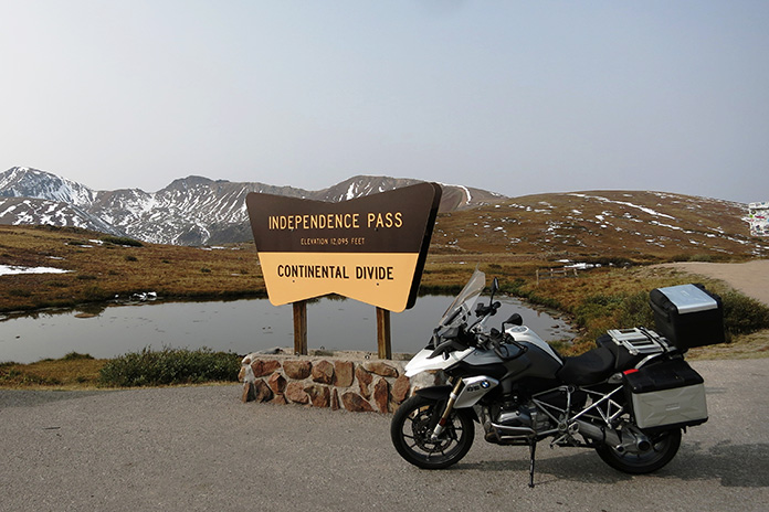
I awoke the next day with a smile because I would get to ride one of the most thrilling roads in the Southwest, which culminates in the thin air and sweeping vistas of Independence Pass. With bags packed and fuel topped off, I headed southeast deeper into the Rockies.
Historic log structures dot the landscape in western Colorado.
Almost immediately after leaving Aspen’s city limits, the road coils into a narrow black ribbon of entertainment. The climb is steep, and the traffic is refreshingly sparse. At times, the road narrows to a single paved lane. The skeletal remains of the area’s mining heyday rise from the undulating grasslands. Spire-like evergreens reach stoically skyward, and snow traces the gray rock peaks like the marbled fat on a good steak.
The bones of historic mining structures add visual texture to this ride.
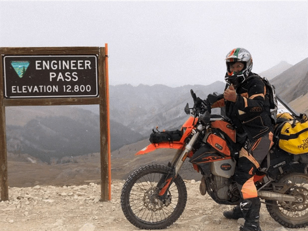
Before I knew it, I was there. The road cresting the tundra above the tree line led me to signage indicating I had reached Independence Pass. At an elevation of 12,095 feet, the summit is the highest paved pass in Colorado (but not the highest paved road; that honor belongs to Mount Evans at 14,130 feet, located about 70 miles to the northeast). I was happy that I was on a fuel-injected BMW GS, as this elevation would be rough on a carbureted bike.
Independence Pass is a thin-aired highlight of this western Colorado tour.
After the requisite photos and a moment to breathe in what little oxygen this elevation provided, I came down from the pass.
The other side of the summit was every bit as thrilling as the climb. Hairpins nearly as tight as those you’d find on a bathroom vanity abound. It’s a 1st-gear descent for the first few miles past Independence Pass, and the views are spectacular.
The visual definition of a “hairpin” curve on the southern descent of Independence Pass.
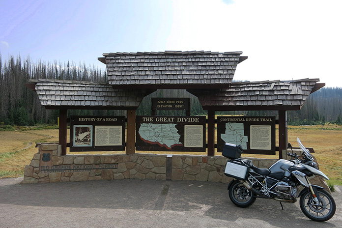
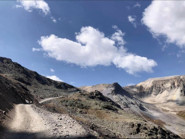
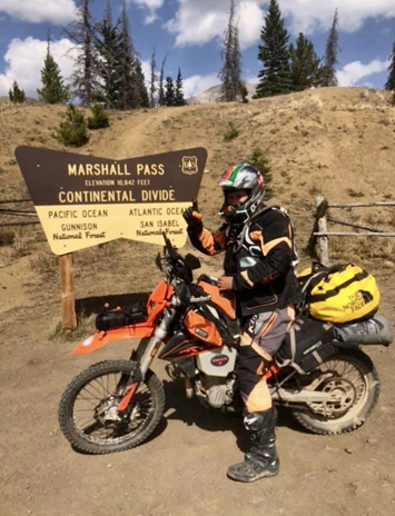
Eventually, the turns relaxed until I reached one of the few straight stretches on the loop. After that, I headed southwest on U.S. Route 160. This ultimately leads to Wolf Creek Pass. Yes, that’s the one in the 1970s song by C.W. McCall. I rode down from the nearly 11,000-foot pass amid numerous warning signs about the precipitous grade and what it can do to truck brakes. There were two runaway truck ramps on the descent that spoke to the danger.
The famed Wolf Creek Pass is a shining star of the Great Divide.
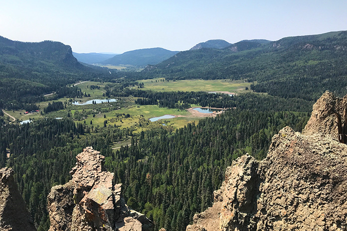
I threw down the kickstand at the viewpoint to enjoy one of the most impressive vistas on the trip. The view serves as a topographical foreshadowing of a descent through jagged rocks and vivid conifers into a grassy valley. The few miles between here and my final stopover did not disappoint.
The view south on U.S. Route 160 is stunning and expansive.
Soaking in the Last Stop of the Western Colorado Motorcycle Ride
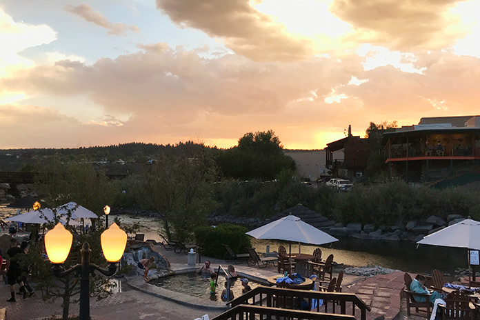
I entered Pagosa Springs road-weary but satisfied. This is another town rich in history but with the added draw of the steaming waters of the Mother Spring aquifer. I made my way to The Springs Resort and Spa, an upscale and visually stunning property that boasts two dozen soaking pools fed by the aquifer.
The natural hot pools at The Springs Resort and Spa in Pagosa Springs are perfect for soaking away the stiffness of the road.
The pools range in temperature from 88-112 degrees, and all offer amazing views of the San Juan River and surrounding mountains. After sampling several of the hot pools, I retired to my comfortable suite and drifted off with visions of the day’s amazing ride dancing in my head.
All that was left of my western Colorado loop tour was a relaxing ride due west back to my starting point in Cortez. There was, however, one more iconic town left on the docket. After about 50 miles of gently curving highway, I came upon Durango.
Durango’s Strater Hotel is one of many stately, historic structures on this ride.
This southern Colorado town is situated on the banks of the Animas River and, like all the others I have visited, has a rich history and well-preserved downtown area. I picked up a to-go sandwich and sat by the whitewater park to watch kayakers navigate the rapids. I put up the kickstand for the last time on the trip on the short jaunt back to Cortez.
Obviously, this is a summer ride. The extreme elevations make for an early winter and late-arriving summer. Some stretches on this route are permanently closed in the winter. Pack with the expectation of large swings in temperature and precipitation. Plan well and enjoy!
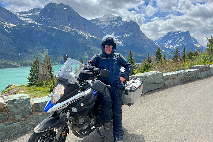
Going-to-the-Sun Road in Montana’s Glacier National Park should be on every motorcyclist’s must-ride list. (Photos by the author)
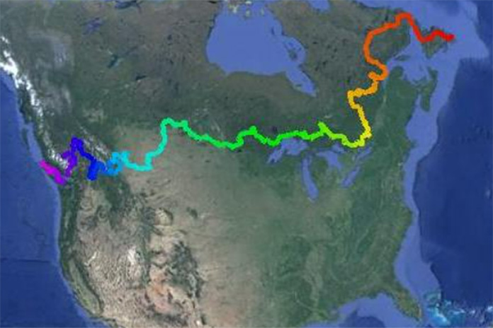
As motorcyclists, we feel drawn to the open road. As Americans, we want to take in as much of what our country has to offer as we can. And as human beings – especially if we’re of a certain age – we want to see our family and friends face-to-face, to hug them and shake their hands and hear and tell stories new and old. Phone calls and texts help us stay in touch, but they are a poor substitute for the real deal. I decided to check all the boxes with a cross-country motorcycle trip.
I live in Southern California, and I have family and friends all over this great nation, from sea to shining sea. I’ve ridden cross-country many times before, but I was overdue for a special lap around America, one where I could see the sights and visit the important people in my life without a strict agenda or schedule. When I opened a Dove chocolate and saw the advice “Live every day with no regrets, it’ll be worth it” inside the wrapper, it felt like a calling. I packed my gear and headed east.
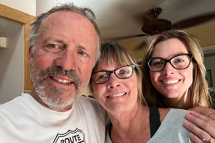
Visiting loved ones like my Uncle Bud in New York was the highlight of the trip.
Family Roots
Back in 1940, my grandparents loaded up their ’37 Packard with all their belongings, including my 10-year-old father, Mark, and his 7-year-old younger brother, Bernard (where I got my middle name) and headed west. Leaving Youngstown, Ohio, they made their way to Route 66 and followed it to Burbank, California, where Grandpa Seth got a welding and fabricating job for Lockheed Aircraft.
Before long, my grandparents purchased a Texaco station that became the family business. Our family still owns the building, which now houses an auto body shop. My grandparents died just before I was born, but I believe I inherited my love and innate abilities for fabricating and restoring motorcycles from my Grandpa Seth. I still use his old Wilton bench vise, hand tools, and other equipment.
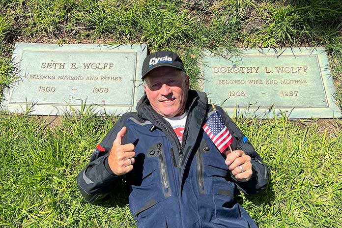
Leaving on Memorial Day, my first stop was my grandparents’ gravesite at Forest Lawn Cemetery in Burbank, California. I asked them to watch over me.
Time was of the essence with my own cross-country journey, some 82 years later. My dad was approaching his 95th birthday, and ol’ Uncle “Bud” (Bernard’s nickname) was pushing 92. They don’t travel anymore, and they hadn’t seen each other in over a decade. I decided to keep the trip a secret from Dad. My plan was to ride to New York and do a surprise video call between the aging brothers.
I left my house in Thousand Oaks, California, on Memorial Day and returned home in time to celebrate the 4th of July. Over a month and more than 10,000 miles, I passed through 33 states, visited and stayed with dozens of people who were already near and dear to my heart, and enjoyed meeting many new friends as well.
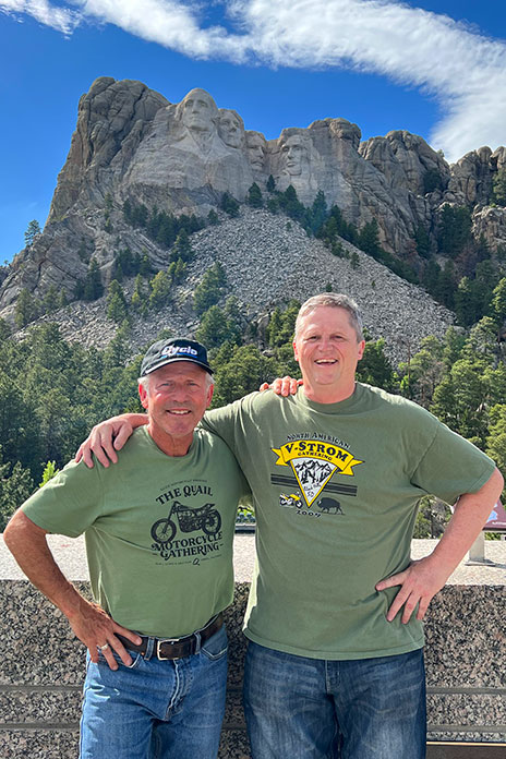
Reuniting with my old friend Carter Kirk in the shadow of Mount Rushmore.
To get ready for my journey, Alpinestars and Shoei/Helmet House provided me with gear, Nelson-Rigg set me up with a waterproof duffel, and my friends at Suzuki were kind enough to loan me a 2022 V-Strom 650XT with an accessory tankbag and panniers. The V-Strom 650 is one of the best bang-for-the-buck adventure bikes out there. It fits me like a glove, has a really comfortable seat, likes to go off-road here and there, and only asked for gas in the tank and PJ1 on the chain every now and again.
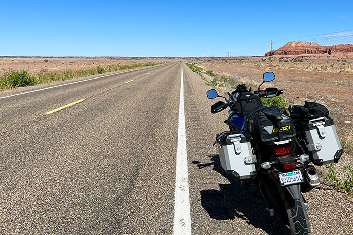
High plains drifting in New Mexico. It’s fun to imagine what’s beyond the horizon.
On the second day of the trip I was tempted to do some off-road exploring near Zion National Park in Utah, but I had a long journey ahead of me, so I thought better of it.
With the bike packed, I said my goodbyes and my prayers, pulled in the clutch, dropped into 1st gear, and rolled away from home. It was a surreal feeling starting a ride of this magnitude, wondering what might be in store for me.
A Cross-Country Motorcycle Trip: Eastbound and Down
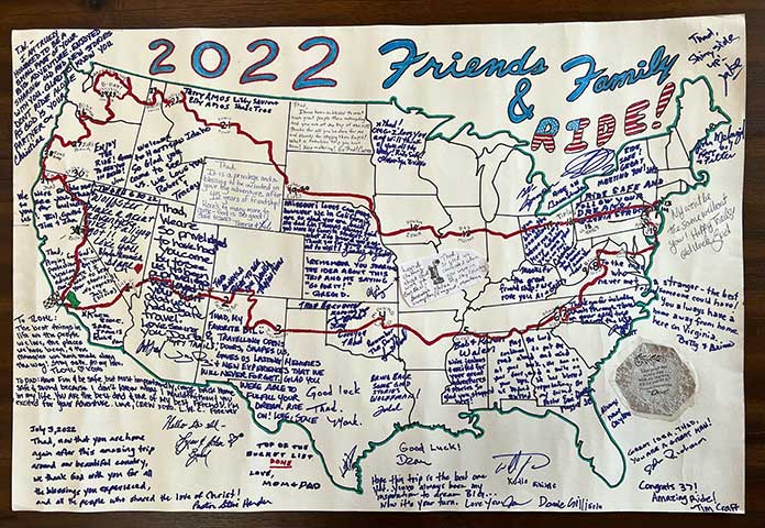
Before departing on this ride, I traced a big outline of the U.S. and each of the lower 48 states on a large sheet of heavy-duty paper, and at the top I wrote “2022 Friends & Family Ride!” I kept it rolled up in a cardboard tube and used it to document my route. Along the way, I had family, friends, and other folks write notes and messages on the map.
My homemade route map signed by friends, family, and others along the way is a special keepsake from my journey.
After riding across the Mojave Desert to Las Vegas, I continued northeast and rode through Zion National Park in Utah. I meandered east to Four Corners, got off my bike, and managed to be in all four states at once with my feet in Arizona and New Mexico and my hands in Utah and Colorado. In New Mexico, I visited friends in Farmington and Tucumcari. As the trip unfolded, I found that most of the time there was another friend or family member with whom I could stay within a day’s ride.
Spreading out over four states at once at Four Corners (Colorado, Utah, New Mexico, and Arizona).
I blazed across the Texas Panhandle on my way to “McDonald Land,” the nickname for where Norm and Lucy McDonald live near Tulsa, Oklahoma. Norm is the “N” in K&N filters, which nearly everyone has run in their bikes or cars at some point. I used to pitstop there in the early ’80s when traveling around the country during my AMA roadracing days. I met the McDonalds through their son, Sam, when we were both novices in 1980. Through K&N Yamaha, Norm and Lucy sponsored countless racers over the years, with Malcolm Smith being one of the most notable. They are wonderful people whose friendship is precious to me. Staying with them again like in the good ol’ days was very special.
It didn’t take long to become friends with Susie at The Korner Shop Cafe in West Virginia.
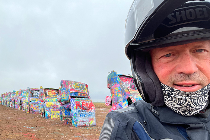
Taking a selfie at the Cadillac Ranch in Amarillo, Texas.
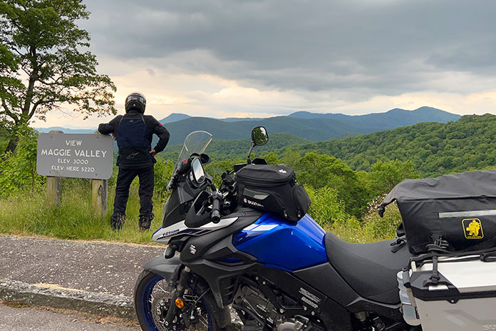
After visiting other friends in Memphis, Tennessee, I skipped across the tops of Mississippi, Alabama, and Georgia and made my way up into the Appalachians and onto the Blue Ridge Parkway. Rider magazine readers have seen plenty of great ride stories from this area, and now I got to do the riding!
The views are endless at the Blue Ridge Parkway’s Maggie Valley Overlook.
The weather was perfect, the scenery was beautiful, and I took some side trips on the 650XT down small roads and trails. In Maggie Valley, North Carolina, I stopped at the Wheels Through Time Museum. I love old bikes and old American stuff, so this place is like heaven to me. Dale Walksler has passed, but his son Matt has taken over and is doing an awesome job keeping the museum going.
With Matt Walksler at the Wheels Through Time museum.
Heading North
I rode up Skyline Drive and into Virginia, where I spent a couple nights at Brian and Betty Richardson’s 19th-century sheep farm. Rider’s former editor-in-chief, Mark Tuttle, connected me with the Richardsons back in 2009, and I raced Brian’s homebuilt Moto-Electra electric bike in the TTXGP series for a few years. In 2013, we set the coast-to-coast world record for electric vehicles on the same bike by crossing the U.S. in 84.5 hours. Brian and I became good friends, and for years I’ve been telling him I would ride up to his farm one day. I finally did, and we spent a day riding together on awesome backroads.
With my buddy Brian Richardson at the Green Briar Hotel in West Virginia. Beneath us was the U.S. Congress’ secret nuclear fallout shelter.
Spending some time relaxing at Brian and Betty Richardson’s sheep farm in Virginia.
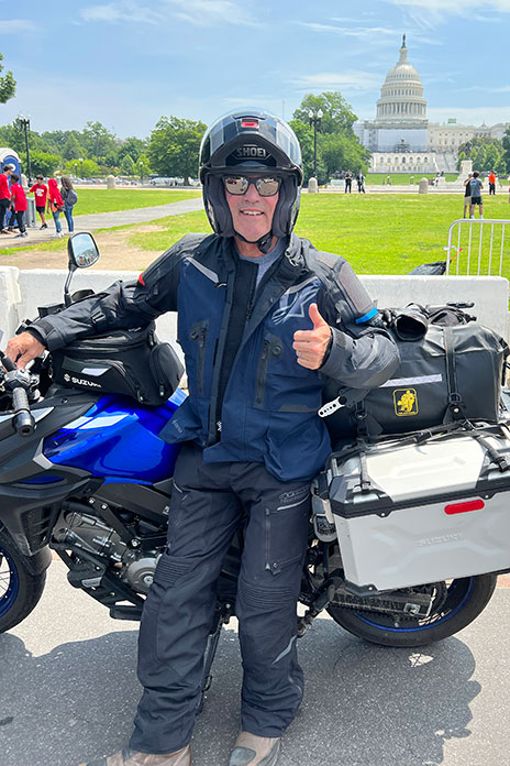
I left the farm in the morning and was soon greeted by a dramatic change in scenery. By midday, I was taking a selfie in front of the Capitol in D.C. I wished I could help straighten things out there, but I decided I’d rather ride my motorcycle. I hightailed it out of D.C. and crossed the Delaware Bay on a ferry from Lewes, Delaware, to Cape May, New Jersey, which is the oldest resort town in America and a neat place to stay.
Cows sure are big in Pennsylvania!
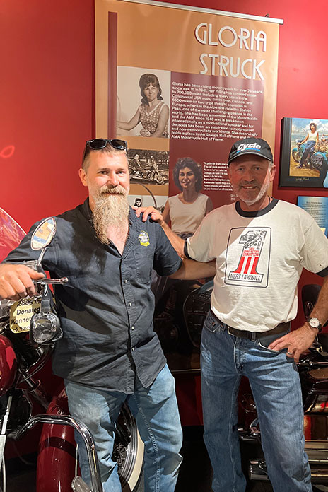
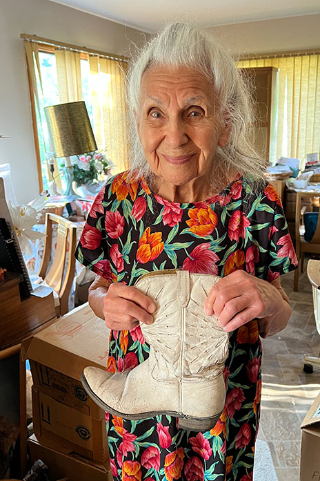
Another special thing about New Jersey is one of its residents: Gloria Struck, the first lady of motorcycling, who is 97 years young. I wrote a story for Rider (March 2013 issue) about Gloria and the Motor Maids, and we have been close friends for a long time. We first met years ago at Daytona Bike Week, where I noticed her Harley had Clorox bottles cut in half and strapped to the handlebar as wind deflectors. I had done that before myself, but when I found out it was Gloria’s bike and that she had ridden from New Jersey, where she had to shovel snow to get out of her driveway, I immediately developed a deep fondness and respect for this woman.
Those boots were made for riding, and that’s just what they did on Gloria Struck’s feet.
Spending a couple nights with Gloria, reminiscing and listening to her talk about riding her motorcycle, or the trike she’s going to get when she turns 100, was absolutely priceless. I highly recommend buying her book, Gloria – A Lifetime Motorcyclist: 75 Years on Two Wheels and Still Riding, which was published in 2018.
Gloria did her first solo ride to Daytona in 1951 to watch the beach races. Dick Klamfoth won that year (and also in 1949 and 1952), and as fate would have it, Dick and I became friends, and I helped him build the Daytona 200 monument, which took several years. He and his wife, Bev, are gone now, but later in my ride, I would carry on our memories by visiting their daughter, Christy, in Ohio.
Washington D.C. was a change of scenery. I didn’t stay long.
The Big Apple
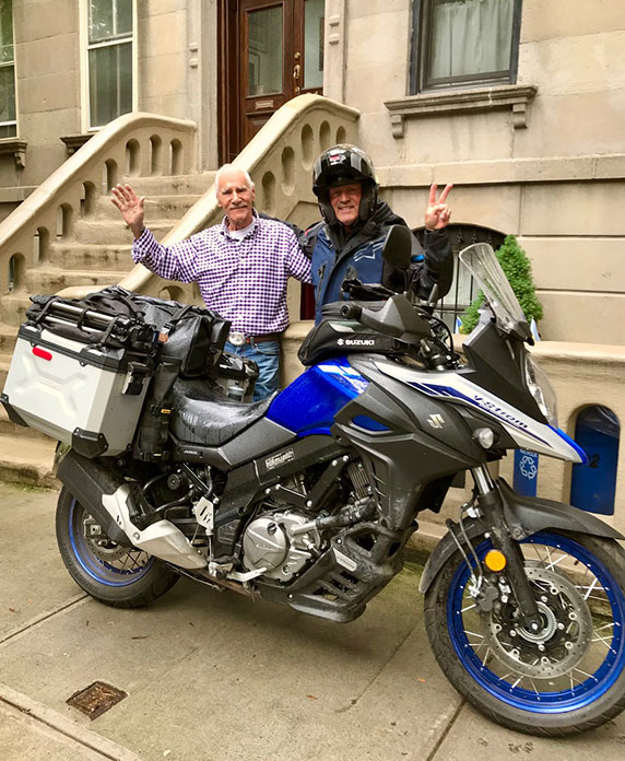
From Clifton, New Jersey, I passed under the Hudson River through the Lincoln Tunnel and popped out in midtown Manhattan. Riding around the Big Apple in the rain was quite an adventure. After taking the Queensboro Bridge over the East River to Long Island City, I finally arrived at the easternmost point of my journey and visited Uncle Bud. It had been hard to keep the secret, but when we surprised my dad with a FaceTime call from his brother and son, it was a very special family moment.
I hope I’ve inherited good ol’ Uncle Bud’s genes. Hard to believe he’s 92.
Saying goodbye to good ol’ Uncle Bud and wondering if it would be the last time we’d see each other face-to-face was emotional, but I laughed as always when he said, “See ya later, alligator!”
Crossing Manhattan again, I was officially on my way home. It felt good to make it out of the big city and know the rest of the ride would be mostly rural countrysides and small towns.
Westward Ho!
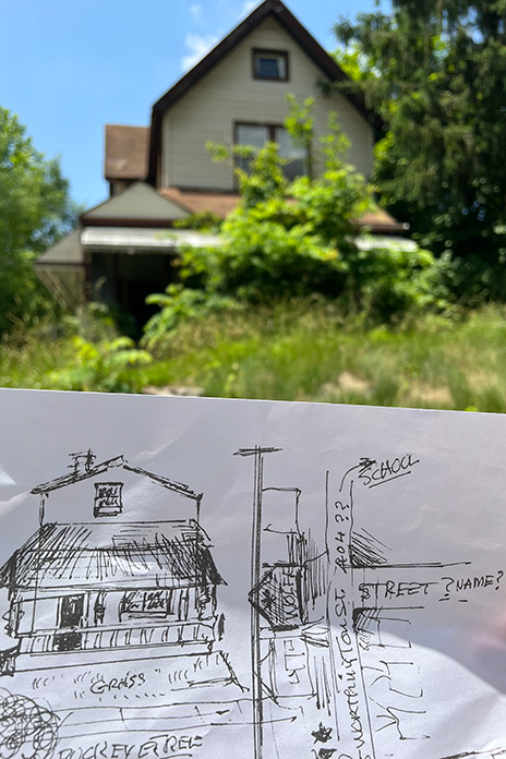
In our family’s hometown of Youngstown, Ohio, I stayed with my cousin John. We had never met and had fun getting to know one another. Using Bud’s recently sketched picture of the family home, we found the now-abandoned dwelling where they once lived. It was like searching for hidden treasure with a map Bud drew from his memory of a place he left at the age of 7! John showed me around, and I imagined my family living there in the old steel town’s heyday. I thought about them in the old Packard driving away from the house on Worthington Street for the last time, looking back at what was being left behind and then looking forward, wondering what life would be like in California.
With Uncle Bud’s hand-drawn map, my cousin John and I found our family’s old home in Youngstown, Ohio.
The V-Strom 650XT and I had fun two-tracking through the Great Smoky Mountains.
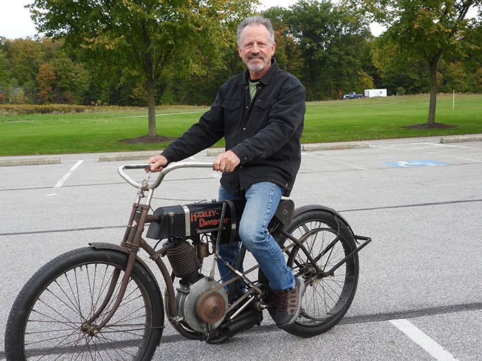
From Youngstown, I rode southwest to Columbus, where I visited the AMA Hall of Fame Museum and then popped in on Bruce Linsday. Bruce is a top guy in the antique motorcycle world with an unbelievable collection of early American motorcycles. Years ago, when we were in Death Valley riding our old Harleys, he invited me to stop by his place so I could ride a particular old Harley dating back to 1905. The factory in Milwaukee has one in its museum, and Bruce has the other one. These two bikes are the oldest Harleys in existence. The factory’s bike is under glass and will never be ridden, so I was fortunate enough to be able to ride the oldest running Harley there is! Quite an experience.
Riding the world’s oldest running Harley was quite an experience for me.
After a stop in Des Moines, Iowa, I continued west to South Dakota. In 2009, I attended the V-Strom Rally in Rapid City on assignment for Rider (April 2010 issue) and made friends with resident V-Strom rider Carter Kirk. He let me borrow his bike for the rally, and I had a wonderful time exploring the Black Hills. Since I was traveling on a new V-Strom 650XT on my family-and-friends tour, I had to visit Carter.
With him on his old V-Strom and me on my new one, we spent a day riding and sightseeing. We stood at the base of Mount Rushmore and took in the majesty of one of this country’s most patriotic treasures. After dinner in Sturgis, we capped off an awesome day with a night ride home through pouring rain and an unbelievable lightning show. When we made it home, I had a good laugh when Carter asked me if I was worried during the ride. I tried to act like I wasn’t.
I visited Christie Klamfoth and her partner Al in Ohio. Her parents, Dick and Bev, opened up the heavens to let their love shine down on us.
After crossing the Great Plains, the Rocky Mountains invited me to explore the high country. America the beautiful!
After visiting Devils Tower in Wyoming, I continued northwest into Montana. I love this part of the country, and after riding through some more open grassland, I was finally rewarded with a view of the snowcapped Rocky Mountains. I rode the incomparable Going-to-the-Sun Road in Glacier National Park, then made my way into Idaho, where I visited my nephew, Robert, and his wife, Tracy, in the little community of Harrison. They recently moved there from our hometown in Southern California to a little house overlooking a lake.
This was about as far as I could go trying to scale Mount Hood in Oregon.
Farther west, I enjoyed riding the Cascade loop in Washington with all the forest roads and the surprising views of white-topped volcanic mountains that appear out of nowhere. After a stop to visit my sister-in-law Jill in Bend, Oregon, I finally saw what I was waiting for: the beautiful blue Pacific Ocean. I punched my fist into the air and hollered “Yahoo!” inside my helmet. I love riding along the western edge of our country.
The Homestretch of My Cross-Country Motorcycle Trip
Back in California, my next stop was Eureka, a nice little coastal town where I stayed with my Uncle Jim and Aunt Jan and visited my cousin Bill. At this point in the trip, I had seen all my living relatives and felt I had accomplished what I set out to do.
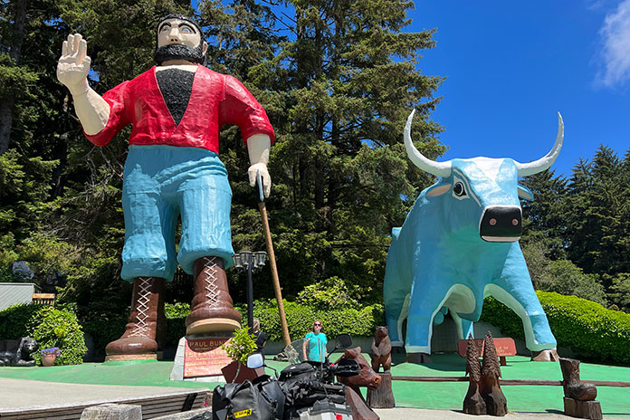
I stopped to say hello to Paul Bunyan and Babe the Blue Ox at Trees of Mystery in Klamath, California.
But there were more miles to cover, such as riding among the majestic coastal redwoods before heading inland to visit Lassen Volcanic National Park in northeastern California. Zigzagging my way through the gold country of the Sierra Nevada, around Lake Tahoe, and past Mammoth Mountain. And then finally crossing the Mojave Desert again to get home.
What a feeling to turn the corner and know this journey had come to an end. There in the driveway was my wife, Jody, and my daughter, Kelly, waiting for me with open arms. I hadn’t even gotten off the bike before the tear-filled hugs began. Wow, what a feeling!
The best part about coming home was seeing my wife, Jody, and my daughter, Kelly.
I arrived home in time for my dad’s 95th birthday, and he ended up passing away peacefully two short weeks later. The timing for this trip was perfect, and I’m glad I was able to make it happen rather than make excuses. In the end, our faith, family, friends, and the memories we’ve made (many with handlebars in hand) are all we have. Nothing else matters.
Scenic U.S. Route 6 near Coudersport, Pennsylvania.
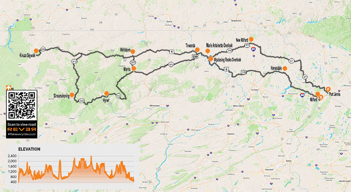
When I hear the first whispers of the siren’s call to hit the road, my desire to rumble off on a multiday trip slowly rises to a crescendo until I have no other choice but to pack my Kawasaki Vulcan 900 Classic LT and ride toward the horizon. On a motorcycle tour such as the one I recently took into the Pennsylvania Wilds on U.S. Route 6, the journey is as important as the destination, so I take time to explore along the way.
Regardless of the destination, the trip itself must satisfy my need for the pastoral – wild land, scenic roads, and the peaceful simplicity of small towns. Cruising U.S. Route 6 deep into the hinterlands of Pennsylvania fulfills all those criteria, making for a deeply enjoyable excursion.
Riding west on Pennsylvania’s famous Route 6, a designated scenic byway, takes you through the Endless Mountains region to the north-central part of the state, known as the Pennsylvania Wilds. This region is devoid of urban/suburban sprawl and comprises over 2 million acres of public land, 29 state parks, eight state forests, ample farmland, and hundreds of miles of rural roadways to ride.
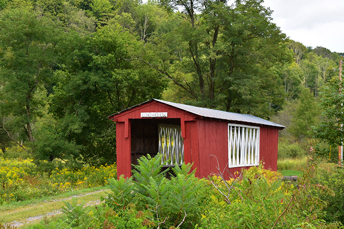
A covered bridge highlights the greenery that graces PA Route 706.
Route 6 provides a diverse and scenic ride through Pennsylvania, but it also traverses the entire country from Provincetown, Massachusetts, to Bishop, California. Construction began in 1926, and it is now the second longest road in the country at 3,227 miles. Route 6 through Pennsylvania is like a wilderness path leading modern-day explorers on steel steeds deep into the Keystone State’s hinterlands, home to bear, deer, coyote, rattlesnake, fox, bald eagle, and elk.
I began my journey by crossing into Pennsylvania from New Jersey on the Milford Bridge over the majestic Delaware River. From Milford, Route 6 begins a rolling, curving climb from the river to the highlands. Throttling on the power, I flew through forests and past ponds until reaching the big enchilada – or locally, the “Big Lake” – Lake Wallenpaupack. Thirteen miles in length, with 52 miles of shoreline and 5,700 acres of surface area, it is the second largest lake within Pennsylvania’s borders. There are six public recreations areas and a wide array of accommodations, outdoor activities, dining, and shopping.
The clear waters of Lake Wallenpaupack.
Wanting to savor this moment – and location – I turned south at PA Route 507 into a parking area and stretched my legs by walking along the shoreline of Lake Wallenpaupack and atop the dam. Route 6 passes the base of the dam as it continues to Hawley, one of the typical turn-of-the-century small towns along this route.
Mostly a two-lane rural highway, Route 6 does have a few congested areas along the way, such as in Honesdale, but Honesdale to Waymart is smooth sailing – or riding. The mountains around Waymart are capped with humongous wind turbines, which are an impressive sight, but I prefer my mountains au naturale.
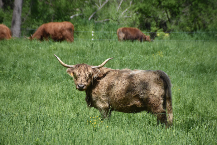
Scottish Belted Galloway cows are as tough as their native Scotland. They didn’t smile for the camera.
Past Mayfield, I left Route 6 and took PA Route 107 to avoid the major congestion around Clark Summit, reconnecting with Route 6 at Factoryville. From there I cruised through the countryside to Wyalusing, where my Vulcan climbed into the mountains with confidence.
At the summit, both Wyalusing Rocks and Marie Antoinette overlooks are must-stops. Wyalusing Rocks, located 500 feet above the Susquehanna River, was once used as a signaling point for the Iroquois Indians. The Marie Antoinette Overlook is named after the former Queen of France of “Let them eat cake” fame; supposedly she once planned to immigrate to this area.
The view from Marie Antoinette Overlook on Route 6.
The river, farmland, and hills unfolded before my eyes, embracing the blue horizon and making me think of Jimi Hendrix’s lyric “Excuse me while I kiss the sky.”
From Wyalusing Rocks, I weaved west with the sweet sound of the Vulcan pulsating in my ears and the cool, crisp air enveloping me. Mount Pisgah State Park is just 2 miles north of Route 6 at West Burlington. This 1,302-acre park has a lake, picnic area, swimming pool, and a scenic overlook of the Endless Mountains region. The park provides a nice stop for rest and a walkabout.
Continuing west on my asphalt “river of dreams” through small villages and the countryside, I eventually cruised into Wellsboro and the rider-friendly Sherwood Motel – my base for exploring more of the Wilds.
A lush farm along PA Route 706.
Wellsboro is a gateway to this rural region and a popular destination for riders exploring the area. It epitomizes small-town 19th-century America so much so that its streetlamps are still lit by gas. Settled in 1806, it was named in honor of Mary Wells, one of the original settlers. Restaurants, stores, and parks are within walking distance of motels. The first night, I had a tasty dinner at the Steak House Restaurant. Initially, I was a bit anxious about dining solo, but the staff was friendly and welcoming, which is typical of most hinterland Pennsylvanians.
The morning greeted me with a cool but sunny day – perfect riding weather. Firing up my Vulcan, I rolled south on PA Route 287 to PA Route 414 west. Route 414 is one of the prettiest rides in the entire state. This section through part of the Pine Creek Gorge area is rustic, with a few small communities and scattered homes.
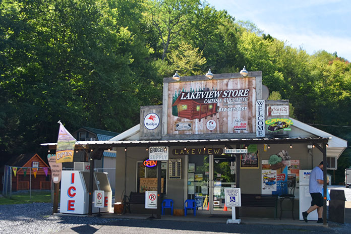
The Lakeview Store near Sinnemahoning State Park on PA Route 872 makes for a perfect snack stop.
Over thousands of years, Pine Creek carved the 47-mile gorge also known as the PA Grand Canyon. The 62-mile Pine Creek Rail Trail is used for hiking, river travel, bicycling, horseback riding, and cross-country skiing. Outside of the wilderness protected area, riders can cruise Route 414 as it slides along for miles next to Pine Creek.
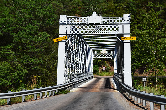
Route 414 through Pine Creek Gorge crosses a one-lane steel-truss bridge.
Parking areas with comfort stations offer river and rail trail access. At the Blackwell Access area, I met a young couple from Maryland who were going to backpack into the surrounding wilderness. We talked a bit, and then I wished them luck and warned them to watch out for the timber rattlesnakes that live in the area. Each June there is an annual rattlesnake roundup festival throughout the region.
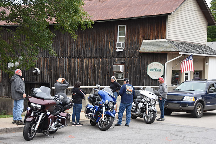
Riders stop at the Blockhouse Cafe.
Continuing my ride, I passed the quaint village of Cedar Run and weaved back and forth on bridges crossing Pine Creek. The roadway crawled up a mountainside presenting a great view. At the intersection with PA Route 44, I roared into the mountains of Tiadaghton State Forest. About 5 miles north of Haneyville, I turned west on Hyner Mountain Road heading toward Hyner Run and Hyner View state parks. With the sun on my face and the sweet mountain air filling my lungs, I was in rider heaven.
The narrow, winding road to the summit of Hyner View can be challenging, but the views are spectacular. Forested mountains roll toward the sky like a vast green sea, and below, PA Route 120 winds through the valley alongside the West Branch of the Susquehanna River.
Hyner View State Park overlooks the West Branch of the Susquehanna River.
I connected with Route 120 and continued west toward Renovo, once a thriving railroad company town of more than 4,000 people that has dwindled to a population of 1,228. Entering Renovo on Route 120, I stopped at a moving memorial for the soldiers who gave their lives protecting our country. A green battle tank that matches the lush grass and surrounding forest guards the memorial.
A Sherman tank guards Memorial Park off PA Route 120 in Renovo.
Route 120 heads west alongside the Susquehanna River and the railroad tracks enveloped by thousands of acres of state forests. This route west to Sinnemahoning is beautiful and one of most desolate areas I traveled through. I rode for miles without seeing another soul. It was the first time on the trip that I felt completely alone.
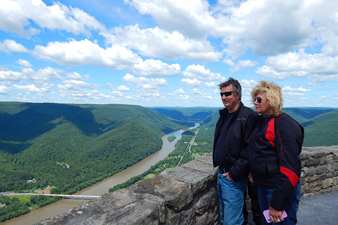
Wyalusing Rocks Overlook on U.S. Route 6 provides expansive views of the Susquehanna River.
People ask if I get lonely or nervous on solo trips, but I actually don’t. Whenever I pulled over for a photo or route check, people often stopped and asked me if I needed help. Sometimes they offered advice on the road conditions or suggested a scenic stop. It reminded me of Blanche Dubois’s line in A Streetcar Named Desire: “I’ve always relied on the kindness of strangers.”
At PA Route 872, I blasted north through Elk State Forest and stopped at George B. Stevenson Dam and Sinnemahong State Park’s wildlife viewing area. Unfortunately, I did not spot any elk. From there, I cruised north out of the mountainous area into lush hills and returned to Route 6 again at Lymansville.
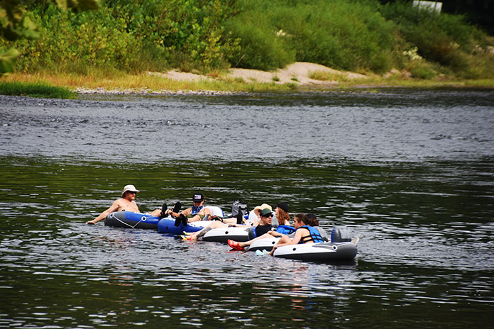
Tubers enjoy the pristine waters of the Delaware River, one of the few major U.S. rivers with no dams.
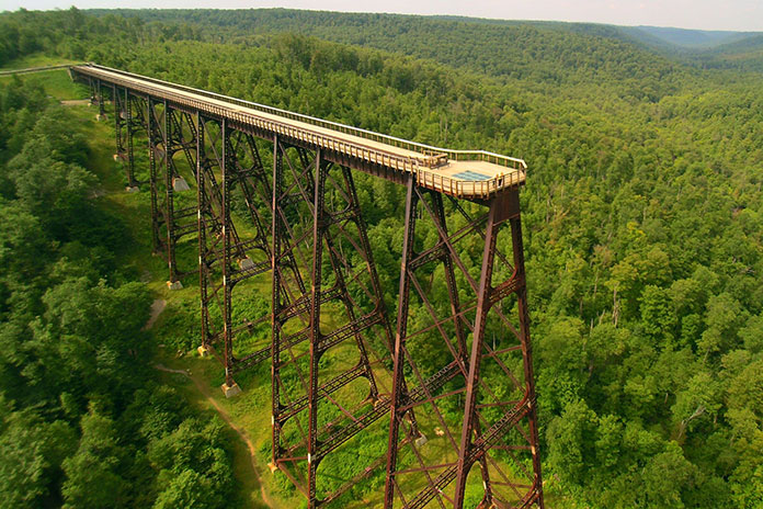
Turning west, I followed Route 6 to Smethport, PA Route 59 west to Ormsby, and then south to Kinzua Bridge State Park, home to the Kinzua Sky Walk. The park’s namesake bridge was once known as the Viaduct, a railroad structure that spanned 2,053 feet across – and 301 feet above – the Kinzua Gorge. Partially destroyed by a tornado in 2003, what remained of the bridge was converted into a pedestrian walkway.
Visitors can now walk 600 feet out on the remaining support towers to enjoy sweeping views of the gorge and surrounding mountains, as well as a glass platform at the end of the walkway for breathtaking views down below. The Kinzua Sky Walk is an especially impressive place to enjoy fall colors.
The 600-foot-long Kinzua Sky Walk at Kinzua Bridge State Park is a popular destination for riders. Alas, motorcycle parking on the bridge is not allowed.
Cruising along Route 6, I made my way back to Wellsboro. There are three recommended stops along the way: Larry’s Sport Center in Galeton, which sells Harley-Davidson, Kawasaki, Yamaha, and Suzuki motorcycles, and the Colton and Leonard Harrison state parks, both of which have impressive views of Pine Creek Canyon.
Back at the Sherwood Motel, I enjoyed a relaxing soak in the warm water of the pool. Afterwards, I had dinner in the lounge of the historic Penn-Wells Hotel, originally built in 1869. Conversing with the bartender and locals, I felt as comfortable as a regular.
The next day, I began my journey home heading south on Route 287 to Morris, but this time I went east on Route 414. And what a great ride it was – weaving and rolling through the countryside, passing farms and surrounded by the green hills on the horizon.
Riders leaving the summit of Hyner View State Park.
Rejoining Route 6 for a spell at Towanda, my Vulcan climbed back up the mountain by the Wyalusing Rocks Overlook, and then I rode PA Routes 409 and 706 through the Endless Mountains region to New Milford.
Somewhere along Route 706, I stopped on a downward sloped shoulder for a photo. As I dismounted, over the bike went. Within minutes, people stopped to help. We righted the bike, I thanked them, and then I continued my ride. I had once again relied on “the kindness of strangers,” and I will pay that kindness forward.
At New Milford, I took a series of pleasantly undulating state routes to Damascus, where I rested and watched Pennsylvanians enjoying the Delaware River. Crossing the bridge into New York, I rolled south on the Upper Delaware Scenic Byway (NY Route 97) toward Port Jervis, which offers expansive views of Pennsylvania and New York.
Along PA Route 872, the author’s Kawasaki Vulcan basks in the beauty of Mother Nature.
As I rumbled back home through New Jersey, I could not help but relive this great Route 6 ride through the Pennsylvania Wilds. I knew the region, its roads, and many other delights would soon be calling me back.
Rider’s editor-in-chief Greg Drevenstedt (left) and American Rider’s editor-in-chief Kevin Duke share a fireside toast. (Photos by Kevin Wing)
Buried deep in my iPhone is a text message I sent to my riding buddies on Feb. 29, 2008 (lucky leap day, as it turns out):
I got the job!! I’m Rider’s new Road Test Editor! Woohoo!
I had just returned from my second interview with Mark Tuttle, Rider’s former editor-in-chief. We had met up for a motorcycle ride, and during lunch at a beachside cafe, he offered me the job.
Working full-time at a motorcycle magazine really has been a dream come true. It’s been an honor and a privilege to ride hundreds of new motorcycles and travel all over the world. But one of the most rewarding parts of my job has been getting to know fellow motorcycle enthusiasts who work in the industry – passionate, intelligent, talented individuals who have become not only trusted colleagues but true friends.
The Wingman
One of those friends is Kevin Wing. He’s one of the best motorcycle photographers in the business, and his work has been featured in Rider, Motorcyclist, Sport Rider, Cycle World, and other leading publications since the ’90s. Wing is responsible for countless inspiring covers and vivid images that bring this magazine to life, and he deserves way more credit for his contributions than we could ever give him.
Like many photographers, Kevin Wing avoids the limelight. I managed to capture a selfie with him (right) and Duke during a lunch stop.
Wing was the photographer on my first Rider photoshoot. A month into my new job, Tuttle asked me to photo model on the Buell XB12XT for the June 2008 cover feature. Wing was patient with my inexperience, coaching me on how to ride 2 feet off the back bumper of a minivan for tracking shots.
Wing is also a perfectionist. He’ll call for as many photo passes as it takes – sometimes dozens of them in a single corner – to get the lighting, focus, angle, and other details just right. On the Buell shoot, I struggled to do repeated U-turns on a steep, narrow road for the cover shot. When I blew it one time and ended up in the weeds, he snagged a few embarrassing frames of me trying to extricate myself.
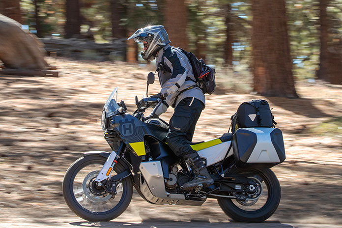
Enjoying fresh pavement on Lockwood Valley Road aboard the Husqvarna Norden 901 and Honda CB500X.
If I’m honest, I’ve never felt like the “talent.” I’m a rider with middling skills who is always trying to compensate for a lifelong habit of cocking my head to the left, inspiring a few riding buddies to nickname me “iLean.” The real talent is the guy behind the camera.
The Dukester
Another industry veteran I’m proud to call my friend is Kevin Duke. He started out at Motorcyclist in the late ’90s and was an editor at Roadracing World and Motorcycle Consumer News before taking the helm as editor-in-chief at Motorcycle-USA.com and then Motorcycle.com. When the EIC position opened up at our sibling publication, Thunder Press (which became American Rider last May), I was stoked when Duke landed the job.
The Honda CB500X is more at home on the pavement, despite its adventure styling and 19-inch front wheel.
Over the years, I’ve attended dozens of press launches around the world with Duke. He was at my first press launch in Gatlinburg, Tennessee, in the spring of 2008, one that will forever live in infamy after one guy crashed (me), nearly every other journalist got a ticket, and one unlucky soul was hauled off in handcuffs. But that’s a longer story best told over a couple of beers…
In January 2013, Duke and I attended the global launch of the BMW R 1200 GS “water” Boxer in South Africa, an event that got cut short on the first day after a British motojournalist crashed and ultimately succumbed to his injuries.
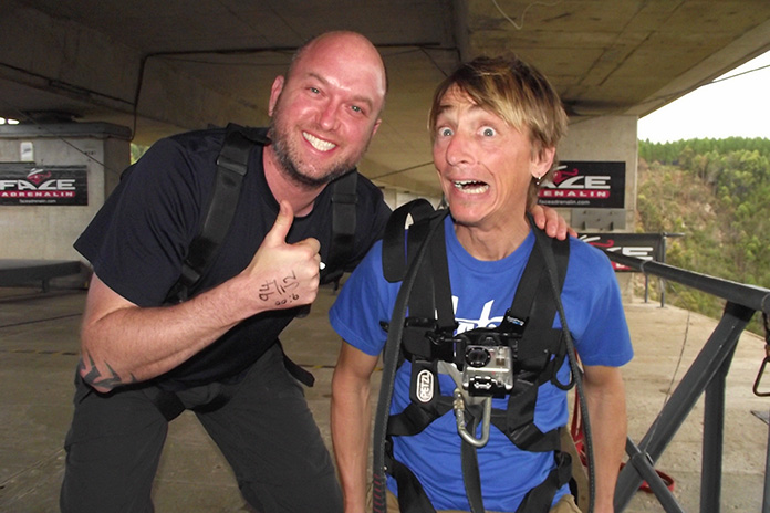
Following the fatal incident, the mood at the launch was somber. We had a free day before our flight home, and Duke and I decided we needed to do something life-affirming. So we borrowed a BMW X1 and drove to Bloukrans Bridge, which, at 700 feet above the Bloukrans River, is the site of the world’s highest commercial bungee jump.
Can you tell which one of us had completed the Bloukrans Bridge bungee jump and which one was awaiting his fate?
I was nervous during the entire two-hour drive there, hoping Duke would chicken out so I could do the same. But he never did, and we went through with it. The jump was two seconds of sheer terror followed by one of the most exhilarating experiences of my life.
The Motorcycle Camping Plan
Duke and I oversee a small editorial team as we work collaboratively on Rider and American Rider. Duke is a former racer and can wheelie anything on two wheels, but now that he runs an American V-Twin publication, his opportunities to ride bikes not made by Harley or Indian are limited.
“Hey Duke, we’re working on this adventure issue for Rider. How about you take the train up here to Ventura, and we’ll go for a ride? Bring your tent and sleeping bag.”
As a full-sized adventure bike with long-travel suspension, the Husqvarna Norden 901 is well-suited for stand-up riding off-road.
We both spend way too much time riding a desk chair, so he didn’t hesitate to accept my invitation. We had a pair of adventure bikes – a Honda CB500X and a Husqvarna Norden 901 – in the Rider garage, and we’d be joined by Wing on our Yamaha Tracer 9 GT long-termer.
You know what they say about the best-laid plans. Duke missed his 6 a.m. train, pushing our departure back by two hours. Deadlines, a bum knee, and aftereffects of a Covid booster slowed down my last-minute packing, so by the time we hit the road it was noon.
Introduced last year, the Norden 901 is Husqvarna’s first foray into the adventure/travel segment. Husky is owned by KTM, and the Norden is built on the same platform as the KTM 890 Adventure. It’s powered by an 889cc parallel-Twin that makes a claimed 105 hp at the crank, and it has throttle-by-wire, a 6-axis IMU, and a full suite of electronic rider aids. MSRP is $13,999, and the touring cases with carriers add $1,030.
First, the Ride
From my house, I can hit California Route 33 with a rock. It peels off U.S. Route 101 near the beach, and after winding through small hamlets like Casitas Springs and Oak View, Route 33 passes a biker hangout called the Deer Lodge and becomes one of the best motorcycling roads in Southern California, entering the wide-open spaces of Los Padres National Forest. I even wrote about the 33 in my cover letter when I applied to Rider back in 2008:
A motorcycling treasure sits in Rider’s backyard. The triple-crown of the Jacinto Reyes Scenic Byway (Route 33), Lockwood Valley Road, and Cerro Noroeste Road has it all: breathtaking vistas, peg-scraping switchbacks, fast sweepers, and top-gear straights.
In Honda’s lineup since 2013, the CB500X has grown into its role as a light, affordable adventure bike. Built around a 471cc parallel-Twin, in 2019 it got a larger front wheel, more suspension travel, and other upgrades. Updates for 2022 include a lighter front wheel, a lighter swingarm, a new inverted Showa SFF-BP fork, and dual front disc brakes. MSRP is $7,199, and Honda’s accessory tankbag, light bar, and panniers bring the as-tested price to $8,517.
Even better, these roads have minimal traffic, especially on a Tuesday. “The Kevins” and I have ridden together many times, and we enjoy a brisk pace. We pushed our bikes hard and gnawed the chicken strips down to gristle. And then, out of nowhere, we received an unexpected gift.
Covering about 25 desolate miles from its junction with Route 33 to the small community of Lake of the Woods, Lockwood Valley Road has suffered a long history of neglect. It was in rough shape when I first rode it 15 years ago, and over the years, it has only deteriorated further. One tricky section is a tangled knot of first-gear corners that go through narrow desert canyons and washes. On one of my first test rides through Lockwood Valley, I dumped a $20,000 BMW R 1200 HP2 Megamoto in a patch of sand that caught me off-guard, cracking one of the magnesium cylinder heads and nearly putting my dream job at risk.
As the Kevins and I turned onto Lockwood Valley Road, we saw that the top layer of pavement had been scraped off. A few miles later, we came upon the paving crew. And then … nirvana!
The recently repaved Lockwood Valley Road was a delight.
All the twists and turns that were such a challenge when the pavement was cracked, patched, potholed, and strewn with sand and rock-slide debris became a jet black, eerily smooth roller coaster like those plastic Hot Wheels tracks you could twist into acrobatic shapes and loops. We were gobsmacked.
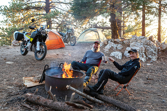
The Actual Motorcycle Camping
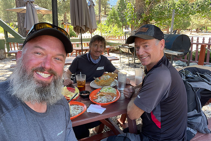
An army marches on its stomach, and so does a crew on a photoshoot ride. We’re all remote workers these days, so rides like these give us a chance to see each other face-to-face and have some laughs. While we sat around a picnic table and scarfed down an XL combination pie at Mike’s Pizza, Duke revealed that Wing had also been the photographer on his first shoot – 25 years ago to the month. We commiserated about the recent heat wave, inquired about Duke’s and Wing’s kids, and discussed the length of my beard. By December, I should be eligible for a part-time gig as Santa.
As California Route 33 follows the winding path of the Ventura River through Wheeler Gorge, it passes through a pair of tunnels built in 1931.
We waddled out to the bikes rubbing our distended bellies, saddled up, and made our way through the alpine community of Pine Mountain Club before spiraling our way up Cerro Noroeste Road to the top of its namesake mountain. Cerro Noroeste is surrounded by the Chumash Wilderness, and sprawled across its 8,300-foot summit under the shade of enormous Jeffrey pines is Campo Alto Campground.
When my brother and I first camped at Campo Alto back in ’06, we had embraced our Tennessee heritage, bringing little more than a box of fried chicken, a bottle of Jack Daniel’s, and bed rolls tossed in the bed of my F-150. We’ve taken Rider staff camping trips to Campo Alto, so it seemed a fitting location for our most recent escape. A week after Labor Day on a Tuesday, it was deserted.
Shaded by enormous Jeffrey pines, Campo Alto Campground is perched atop Cerro Noroeste at 8,300 feet in Los Padres National Forest.
As the Kevins set up camp, I rode down to the general store in Pine Mountain Club and stocked up on beer, chips, sandwich fixin’s, and firewood. We soon had a toasty blaze going and cold cans of IPA in our hands. Heavy rains had spun off from Cyclone Kay and soaked the mountains only a day or two before, and the petrichor mixed with the smell of pine and wood smoke.
“Hard to believe we’re so close to home,” Wing said. “Feels like we’re a million miles away.”
We had ridden less than 100 miles since leaving Ventura, and it was probably half that to the campground as the crow flies. But we were on the top of a mountain surrounded by wilderness, and there was no one around but us.
“Trust me, Duke, if we just bomb down this hill, go over the river, and through the woods, we’ll get home an hour earlier.”
After the sun went down, it dropped into the 40s, so we huddled close to the fire, sipped some 10-year-old Henry McKenna bourbon, and told war stories about press launches, photoshoots, close calls, and embarrassing moments. (Yes, I told the Gatlinburg story.)
Ours was an adventure with a little “a.” We didn’t do much preparation or planning, nothing went wrong, and we were back home in less than 36 hours. But we slept in tents under the stars, had fun, and asked, “Why don’t we do this more often?” Even a brief escape with good friends does wonders for the soul.
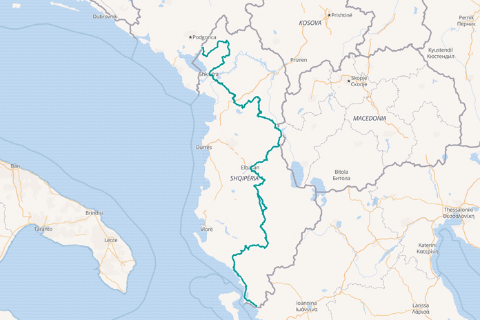
Albania via the TET exceeded all my expectations; it’s truly an ADV riders’ paradise.
The seeds for my journey on the Trans Euro Trail were planted in 2015, when I toured Europe on my BMW R 100 CS. I had the briefest sample of Albania, an afternoon riding the most dramatic mountainous landscape on a pristine ribbon of tarmac. Smooth riding perfection soon turned into a perilous off-road trail that put my bike and me well out of our comfort zone. As snow fell and my extended sump rebounded off rocks, I made a rare sensible decision and turned back to Montenegro, vowing to return better prepared one day.
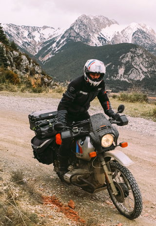
The author modified his 1982 BMW R 80 ST with late-’80s GS parts such as the tank, seat, fairing, bash plate, front wheel, and rear shock.
This time around I took my 1982 BMW R 80 ST. It’s not a true off-road bike, but modified with a wide handlebar, a 21-inch front wheel, a longer rear shock, and a bash plate, it’s more than capable of taking on tricky terrain. With countless days on Wales’ toughest greenlanes, plus an enduro race under my belt, I was ready to take on Albania properly.
Choosing a route was easy. The Trans Euro Trail is an incredible resource. With nearly 32,000 miles of off-road trails mapped across Europe, it’s a lifetime’s worth of riding. The Albania section covers 500 miles, which could be a day’s riding on tarmac but is a lot longer off-road. Free GPS routes are available at TransEuroTrail.org, and there’s even a TET app for Android phones that allows you to download all the routes.
The Trans Euro Trail is 500 miles of Albania’s toughest trails, stretching from beautiful beach resorts of the south to snowy mountains in the north.
Albania is inconveniently located nearly 2,000 road miles away from my home in Wales. No doubt there’s some spectacular riding on the direct route, but I’ve traveled its roads plenty of times before, and there are too many motorway miles that crush spirit and wear out knobby tires. Instead, I took the ferry to Santander, Spain, with further ferries taking me to Sardinia, Sicily, mainland Italy, and finally to Albania. It’s a great alternative route with fewer motorway miles, beautiful landscapes along the way, and overnight ferries costing not much more than a hotel room – and you can sleep while the boat does the work for you.
The route also gave me a chance to sample other sections of the TET and get a feel for what to expect from it.
When the ferry landed in sunny Santander, I headed south to join the TET at the nearest jumping-on point. As soon as my wheels left the tarmac, I hit thick, wet clay, and within 800 yards, I was on the ground and struggling to pick up the heavily loaded bike as my boots slipped in the slick clay. For a moment I just stood there, staring at my once-pristine bike wedged in the mud on its side. Maybe I wasn’t as ready for this as I thought.
Rain on the plain in Spain led to muddy sections of the TET.
Eventually I got the bike upright, and the next 10 miles was an arduous crawl through deeply rutted clay across unremarkable farmland. The Michelin Anakee Wilds, usually a very capable 50/50 tire, failed to get any real grip as the clay filled the tread, and I had to paddle my feet just to stay upright. The bike was caked in clay, filling every gap between wheels and frame and baking itself solid against the hot engine. I was dirty, hot, exhausted, and soaked with sweat.
Is this what the TET is about? I can fall off my bike in muddy fields back in Wales anytime I want.
As I made my way to Barcelona via the Pyrenees, I hopped on and off the TET at convenient points, using paved roads to make up some miles in between. Thankfully the riding improved in both trail quality and scenery, although I was occasionally hindered by deep snow in the higher ground.
Forty years on, the BMW Airhead is still many riders’ go-to machine for long distance adventures.
I rode a short section of the TET in Sardinia, fast gravelly trails over beautiful hills, and for the first time I could see the wheel tracks of other bikes.
In Sicily, I enjoyed a few easy days of touring and sightseeing before making a beeline for Brindisi on the southeast coast of Italy, where I boarded the overnight ferry to Vlorë in Albania.
My Welcome to Albania
On arrival in Albania, I realized my first mistake: I had my passport, motorcycle insurance, Covid pass, and international driving permit but no vehicle registration documents, which turned out to be vital for crossing borders in this part of the world. In the early hours of the morning, I woke my fiancée back home to email a PDF copy. The border guards were not overly impressed, but it was enough to get me through.
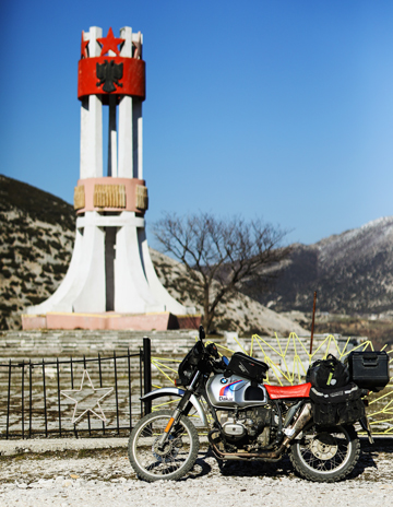
Albania’s troubled history lays in plain sight throughout the country, everything from huge monolithic war monuments to thousands of bunkers built during the 44-year reign of communist leader Enver Hoxha.
To join the TET, I took the most direct route, which seemed like a major road when looking at Google Maps. On arrival, that road turned out to be a stone military road built by the Italians during World War II – and barely maintained since. The frugal suspension travel on the stock ST fork made for a bumpy ride as I tried to pick the best line across the stones. As spectacular as the views were, it was tough going.
If this is just the road to the TET, how hard is the actual TET?!
When I joined the TET to make my way to the most southerly point of the route, I was surprised to find a smooth tarmac road that winded up in the hills past some spectacular monolithic war monuments before turning to dirt as it dropped down to the warm sunny coast. A spectacular ride, not too challenging, and I finished the day with a pannier-cooled beer on the beach watching the sun go down. A trail rider’s dream!
The grueling trails aren’t without reward.
The next day, I began making my way back north and inland, using tarmac roads to skip the section of the TET I’d already done. When I rejoined the dirt trails, they once again wound into the hills, passing tiny villages of makeshift homes, friendly farmers herding livestock, and rivers cutting their way through gorges and flowing under precarious bridges. One thing the TET has done is bring commerce to these faraway places that otherwise see very few tourists. Groups of trail-weary bikers buy drinks and food and camp in the fields – or in my case, take refuge in the basic B&Bs that cost next to nothing to stay in.
The Trans Euro Trail to Some; the Daily Commute to Others
It was my third day in Albania, but I’d already been away from home for 15 days. The trails had been spectacular, but I’d heard they were tough, and so far I hadn’t experienced too much of a challenge. That was about to change.
After an early-morning meal of a banana, cheese triangles, peanuts, and some unidentified tinned fish purchased at a small corner shop, I dropped down the mountain into the town of Gjebes where I saw a battered old Kawasaki 200 trail bike. Its owner soon appeared and introduced himself with well-spoken English. His name was Djem.
When I checked the GPS that morning, I noticed the TET offers two options: a straight(ish) 10-mile section or an alternative 40-mile detour into the hills labeled as “wet option.” The shorter section follows the river, so I asked Djem if it could be ridden this time of year.
A solitary donkey, hauling hay through a remote village … just another day in the Albanian hills.
“Sure, I’m going that way to work this morning. You can follow me, but I’m running late.”
Djem set off at a pace down the mountain trail, ably carving the best line at speed, which I tried to follow while taking liberties with the ST to keep up. So far on this trip, I’d ridden with a “this bike has to get me home” attitude, but that was thrown out the window.
During drier spells, the route along the river bed can save a major detour into the hills.
As advertised, we left the road and dropped onto the vast rocky riverbed. Djem weaved a line from bank to bank, bouncing over the stones and occasionally plowing through the river. As exciting as chasing Djem was, after five minutes, I thanked him and said farewell. He left me with one bit of advice: “When you see the second village, make an exit. After that the water is too deep.”
Realizing our last river crossing was rather photogenic, I decided to take the opportunity to take a much-needed rest and shoot a picture. I made the crossing several times until I was happy with the shot and continued on my journey – only to completely misjudge the climb up the riverbank that I’d just done five times over and topple into the river.
It only takes one moment like this to feel a long way from home.
My bike was upside down, and my phone mount fell off and went floating down the stream with the phone inside. Petrol was pouring out of both carbs, so I immediately shut off the taps. With the bike at an awkward angle on the riverbank, I couldn’t get it fully upright with the weight of all the luggage. I was forced to drag the bike to a more favorable position, which meant the whole bike was now in the river. After a lot of swearing and my new deadlift personal best, I got it back upright. Thankfully the bike suffered no damage, and I came out with just a nice lump on my shin as a prize. I managed to rescue my phone from farther down the river, but it was fully drowned and lifeless.
Fir of Hotova National Park.
After draining the carbs and a few nervous cranks of the starter motor, the ST spluttered back to life, belching a plume of damp, oily fumes as it cleared its left cylinder. With a dead phone and no GPS to follow, there was just the small matter of navigation. I could see where other vehicles had traveled for the most part, but in sections the pathway seemed to disappear into rocks, leaving me aimlessly bumping around the riverbed searching for a passable route.
Every now and then the reappearance of Djem’s wheel tracks reassured me I was on the right track, only to disappear into water, nowhere to be found on the other side. I plunged in and out of the river, one time beaching the sump on a hidden rock and losing all traction. After that, I began walking the river crossings first to assess a safe route, my boots filling with water as the crossings got deeper. I started wondering if, while focusing on my riding, I’d accidentally gone too far. After nearly two hours, I was relieved to see the second village, and I rode back into relative civilization. Finally, a chance for a drink in a modest Albanian refuge and to empty the water out of my boots.
This was my big adventure for the day, but to Djem it was just another commute.
The Climb to Theth
In stark contrast to the slog across the riverbed, the next day involved fast, open, well-graded trails. For the first time, my speed stayed consistently above 30 mph, and I made good progress, leaving only 75 miles of the TET remaining by the time I reached my accommodation. It was a smart-looking hotel from the outside, but inside it was barely decorated and revealed some dubious building standards, such as a 230-volt socket in a wet room within splashing distance from the shower head and a polished public balcony with no railing.
Albania’s many gravel roads are slowly being replaced by tarmac.
After surviving an overnight stay in the hotel, I was ready to take on the final section, a jaunt into the Albanian Alps arriving at Theth, one of the country’s top tourist draws. The trail started as tarmac but soon degraded into tough, rocky, technical riding on a path not much wider than a small car and a plunge to certain death as the reward for lost concentration.
The back road to Theth is a tough trail with very little margin for error.
By midday I felt like I’d been climbing forever, but I’d only covered 12 miles of the road. The ST was already losing a significant amount of power due to the altitude. It wasn’t until late afternoon that I finally reached Theth, but the effort had been worth it. The harsh, desolate landscape gave way to an oasis of color and beauty in the hills. Charming little houses dotted a towering, snow-tipped landscape, with a blue crystal-clear river running through a deeply cut gorge.
During the winter months, the main road into Theth is impassable due to the snow, cutting off the village from the outside world.
Mercifully, the ride back out of the hills was a smooth tarmac road, albeit with 6-foot walls of snow towering on either side, razor sharp hairpins, and a dizzying descent down the mountain. Despite the evening drawing in, the air warmed as I got closer to the sea, the roads opened up, and the ST regained power as it breathed more oxygen. Not only did the 40-year-old BMW complete the Albanian TET, but it had excelled as a riding companion.
When it comes to an adventure bike, less is certainly more. Traction control, ride modes, adjustable windscreens, and TFT displays are all just distractions around what you really need: a solid, dependable machine that’s easy to live with day to day and can be fixed with basic tools on the road. The ST is light for an adventure bike, coming in at just over 440 lb with fluids compared to a whopping 550 lb on the latest R 1250 GS. In fact, with most of Albania’s vehicles being around 30-40 years old, the ST fit right in!
I don’t like describing my bike as a “classic.” The word suggests a machine kept for its history and novelty, but Airhead BMWs aren’t there yet. To me, they still cut it amongst the best, and their work is not yet done. With the Albanian TET under my belt, I’m now looking toward the next adventure on the ST.
Taking a break at Hurrah Pass during our warm-up ride on Chicken Corners Trail.
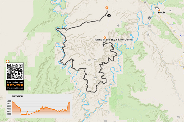
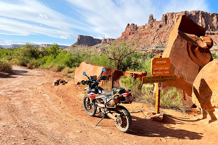
White Rim Trail – or White Rim Road in national park parlance – is a 100-mile unpaved route that loops around the Island in the Sky mesa in Canyonlands National Park near Moab, Utah. It’s on the bucket list of many dual-sport and adventure riders, and rightfully so. The scenery is spectacular, and the trail is ridable by anyone with a modicum of off-road experience.
White Rim Trail, named after the layer of White Rim Sandstone that it runs on top of, was built in the 1950s by the Atomic Energy Commission to access uranium deposits. The mines didn’t produce much ore and were abandoned, and the road became part of Canyonlands after it was established in 1964.
Although White Rim Trail is a rough and rugged route, only street-legal (plated) motorcycles and high-clearance, four-wheel drive vehicles are permitted. Off-road-only dirtbikes, ATVs, and side-by-sides that are common on many trails around Moab are prohibited, which helps keep noise and traffic down. There’s also a daily limit of 50 day-use permits.
Since the trail is within Canyonlands, a national parks pass or entrance fee ($25 per motorcycle, good for seven days) is required. Day-use permits are free at visitor centers, but a $6 fee is required for permits purchased online at Recreation.gov. There are several campgrounds along the trail that require overnight permits for an additional fee. In the spring and fall, reservations are strongly encouraged.
White Rim Trail runs atop a layer of White Rim Sandstone below the Island in the Sky mesa.
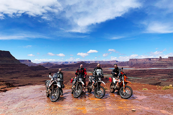
The plan was for four of us – Bruce Gillies, Vic Anderson, Kevin Rose, and me – to ride the entire White Rim Trail in one day. We would be traveling light, with all of us riding KTM 690 Enduro Rs. As enjoyable as camping would be in such a beautiful place, it requires gear that would’ve weighed us down, and whatever was in our saddlebags or panniers would be subjected to paint-shaker conditions for hours on end. Instead, we rented a house in Moab that served as our base for two days of riding.
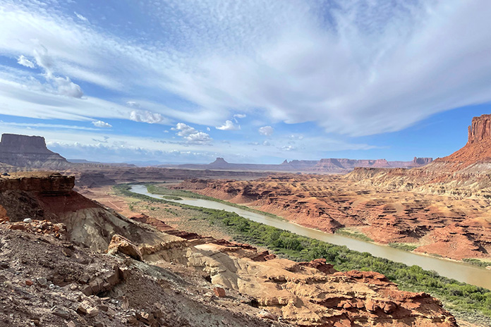
As a warm-up for the White Rim, we spent our first day riding Chicken Corners Trail, a 42-mile out-and-back route on Bureau of Land Management land that passes through Kane Springs Canyon, goes over Hurrah Pass, and runs along a high sandstone bench on the southern edge of the Colorado River. We got hammered by rain early on, but then the clouds parted, and we enjoyed a fun, scenic ride. The trail ends 400 feet above the river across from Dead Horse Point Overlook, the filming location for the final scene in Thelma and Louise when they drive off the cliff.
Hidden from view near the patch of green is the Colorado River, which joins with the Green River below the southern tip of White Rim Trail.
Having obtained our day-use permits online, the next day we left the house around sunrise and rode north on U.S. Route 191 past Arches National Park and then turned west on State Route 313. There’s no gas in Canyonlands, and the nearest gas station is about 30 miles away in Moab, so completing the loop requires at least 160 miles of range. We were equipped with auxiliary fuel canisters just in case.
White Rim Trail is a two-way road, so it can be ridden in either direction. Our plan was to ride it counterclockwise, saving the famous Shafer Trail for the very end. We turned west on Mineral Canyon Road (BLM 129) before entering Canyonlands and followed the long, flat, well-graded dirt road for about 12 miles.
When ridden counterclockwise, White Rim Trail passes through Bureau of Land Management land before entering Canyonlands National Park.
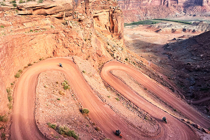
The road into Canyonlands climbs up onto the Island in the Sky mesa, which is where the visitor center and many RV-clogged overlooks are located. Since the White Rim is below the mesa, riding it in either direction requires going down a series of steep switchbacks to get to the trail.
Getting to White Rim Trail from atop the Island in the Sky mesa requires a steep, switchbacked descent to the rim and then a similar ascent at the end.
On a crisp morning in late May, we peered down into the red sandstone canyon carved by the Green River and descended to Horsethief Bottom. After passing the Canyonlands National Park boundary sign, we cruised along the flat trail and took in the full spectrum of colorful scenery: green vegetation along the river; layers of red, pink, yellow, white, and gray rock; and blue skies sprayed with tufts of white cirrocumulus clouds. Off in the distance was Canyonlands’ Maze district.
Riding along the Green River, with Canyonlands’ Maze district off in the distance.
Our first challenge was crossing a sand wash where Upheaval Canyon dumps into the Green River. If the Green is running high, the wash can be flooded and make the trail impassable. We blasted through on the gas and soon found ourselves at one of the two most technical sections on the trail: Hardscrabble Bottom. Since we rode the loop counterclockwise, this section was downhill, and we picked our way along without incident.
Even though it was a Saturday, we rarely saw others on the trail. We waved to a group of Jeepers at a campground, and we passed a few 4x4s and mountain bikers followed by support trucks. Otherwise, it was just the four of us enjoying the sweeping views and a fun trail with minimal dust thanks to the previous day’s rains.
Box canyons, hoodoos, buttes, and spires are common sights in the eroded landscape of Canyonlands National Park.
The second technical challenge on White Rim Trail is climbing up and over Murphy’s Hogback. Our KTMs were perfectly suited for the terrain, and we again made it through without any problems. Bigger ADV bikes would be more of a handful here but certainly capable of getting through.
While some of White Rim Trail is red dirt and sand, miles of it are on bare sandstone, which makes for a bumpy ride. Long-travel suspension, good ground clearance, and a sturdy skid plate are essential.
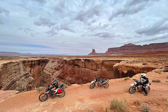
Pausing to admire the view. Parts of White Rim Trail run right along the cliff’s edge, and there’s no fence or guardrail.
The sky had become progressively cloudier throughout the day, and by midafternoon, dark clouds blotted out the sun. At the junction with Potash Road, a ranger checked our permits before we began the final climb up the Shafer Trail switchbacks. This section of trail is accessible by anyone visiting Canyonlands, so we worked our way to the top around not only Jeeps and mountain bikes but Toyota Camrys full of Instagrammers too.
The switchbacks of Shafer Trail marked the end of our White Rim ride.
A few fat raindrops began to fall as we exited the trail. We made a hasty retreat back to the house to hoist celebratory beers and share stories about our adventure.
Snowmobile trails become motorcycle trails during the summer. (Photos by the author)
After months of planning and a morning of pavement riding, we arrived at a section of the Trans Canada Adventure Trail near Huntsville, Ontario. Our plan was to ride about 900 miles of the TCAT, which stretches 9,000 mostly off-road miles from Newfoundland in the east to British Columbia in the west (see sidebar “TCAT 101” at end of the story).
Our group was a fairly diverse threesome of riders. Dan, who had some dirt-riding experience, was concerned with how his Yamaha Super Ténéré would handle some of the tighter, more technical parts of the trail. Greg’s KTM 790 Adventure was probably the most off-road capable bike on this trip, but with almost zero dirt-riding experience, he didn’t know how he would handle the rigors of the trail.
I had the most dirt-riding experience, and with my new-to-me, BBQ-black enamel painted Kawasaki KLR650 – easily the ugliest bike on the trip – I was probably the least concerned with dropping my bike.
Dropping a bike in soft sand is a rite of passage.
Within minutes of getting on the TCAT, we were faced with a fairly steep hill to climb with good-sized rocks and ruts. I made it to the top, but Greg lost momentum and fell, breaking his left side mirror. A broken mirror only five minutes into the off-road portion of the ride was not a great start. After the required photo, we righted his bike, Dan made the hill, and we carried on.
A few miles up the trail was the first deep, long water crossing with a pond on both sides. Greg again stumbled and got caught in a rut. In one scary moment, Greg fell, getting his bike twisted around and aimed directly into the pond we were crossing. One inadvertent twist of the grip and his bike would still be in that pond today. Getting it out ensured that both his and my boots were soaked, as waterproof boots are only effective when the water is not up to your knees.
Greg heading the wrong way through a pond.
After Greg had another fall in some deep sand, we decided we should start looking for a spot to camp. Our plan for this ride was to camp on public Crown land (see sidebar) as often as possible to add to the adventure and reduce our costs. There promised to be a lot of Crown land up north, but we knew it might be harder to find where we were at that point.
While looking for a camping spot, Dan led us through a puddle that looked on the surface like every other one we had recently splashed through. But this one was different. As Dan rode into it, his front wheel disappeared into the water, followed by the rest of his bike nearly up to the seat. He quickly hit the kill switch to avoid sucking water into the airbox and was stuck deep in the muck. After the requisite laughter and photos for posterity, Greg and I pulled him out backwards using a tow strap we had brought for such occasions. Now Dan was a member of Team Water-Soaked Boots.
Dan’s Super Ténéré deep in the muck. It took two of us, a tow rope, and water-filled boots to pull him out.
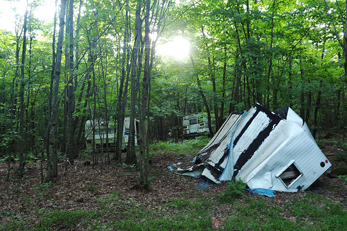
Exhausted and fearful of future bike-sucking puddles, we left the trail and camped in an area with several abandoned RV trailers and a bus, left to rot away in what appeared to be an unofficial RV graveyard.
Camping at an unofficial RV graveyard the first night fueled our zombie dreams. Photo by Dan McPhee.
After a night filled with zombie RV nightmares, we found the TCAT again. The trail turned from an abandoned, pulled-up rail line to a narrow one-lane “road,” to a two-lane logging road, followed by a highway near North Bay, then back to an old rail line again. The variations of the route ensured that we remained focused, monitoring the terrain for rocks, potholes, and water. After what seemed like forever along an old rail line, heading west directly into the setting sun, we camped in my aunt and uncle’s backyard, which is a bit off the trail on a beautiful lake near Sudbury.
Crossing a bridge along an old rail trail between North Bay and Sudbury.
In the morning, we continued along the TCAT to an old rail bridge that we were not brave – or stupid – enough to cross. It seemed about 450 feet long and at least 100 feet high with no side rails. Many rail ties were missing, broken, or burned. There was evidence of snowmobile tracks on the bridge, but we agreed that trying to ride our bikes across was a terrible idea, so we backtracked and got on the highway toward Sudbury.
We crossed many bridges on the Trans Canada Adventure Trail, but we deemed this one too risky. Photo by Greg Fabris.
Once back on the TCAT north of Sudbury, we were totally alone. The road turned into a single lane with trees on each side. If two cars were to meet here, they would have to negotiate a path to allow each other to get by. We didn’t see any cars though – or anyone else. A stop near a river gave us a chance to enjoy the natural beauty and sounds of a seemingly endless supply of rushing water. The isolation was a rarity for us, and the peace of shutting our bikes off in the middle of the trail and hearing nothing but the gentle breeze through the trees never got old.
The TCAT offers some alternate technical sections that roughly parallel the main track. One section we took follows a power line cut through the woods and offers up some decent challenges, including rocky ascents and descents. Several water crossings gave us some difficulties and wet boots, but we eventually made it through.
Having friends along for the ride means blunders are well-documented and help is available when you need it.
‘It’s log, log! It’s big, it’s heavy, it’s wood!’
Once off the technical section, the track had us on a road where the only traffic was logging trucks. There were three tire tracks in the gravel, and we tried to stay on the farthest right one, especially around corners, because the trucks use up the two left tracks and then some.
The lead dog stays dust-free on a logging road south of Shining Tree.
We almost choked in the dust thrown up by the trucks. One time, after two trucks went by in a row, I could hardly see the road in front of me and had to slow down for fear of going off the side.
We found a nice camping spot just off the road with an outhouse, which, at this point in this isolated part of the province, was a luxury for us.
Our campsite near a logging road. Dust hangs in the air from the trucks roaring by a few yards away.
After making it to Shining Tree the next morning, we bypassed the 60 or so miles of logging road the TCAT follows that would’ve taken us to Timmins and instead got on Highway 560 toward Watershed. The track again took us on a logging road toward Chapleau, where we stocked up on groceries, knowing that the next stretch would keep us away from civilization for more than 24 hours along some snowmobile trails toward Wawa.
Some bridges on the old rail trail have been updated and are easily passable for vehicular traffic.
Leaving Chapleau, we rode on gravel roads for a while, and we started searching for a camping spot. Our goal was to find a spot that was roomy with plenty of space for a fire, as well as water nearby for swimming and collecting our drinking water. In this part of the province, there is a ton of Crown land, but our standards meant that we had some trouble finding a good spot that day. We finally found a seldom-used boat launch where we set up our tents as the sun was setting. We had a great fire on a beautiful sandy beach, listening to the calls of the loons on the otherwise deserted lake under the glow of the nearly full moon.
A beach campfire by an isolated lake makes for a great ending to a great day.
The next day our gravel road turned into a snowmobile trail, wide enough for a truck but with a lot of rocks, sand, and hills. Trails that are smooth and easy in the winter on a snowmobile can be treacherous in the summer on a motorcycle.
Hello? Anyone Out There?
Isolation was our constant companion. We had seen only a couple of people since the previous afternoon in Chapleau. As we were riding along, a black bear suddenly darted out about 20 feet ahead. He quickly vanished into the bushes, but the shock of it stayed with me for a while, so I slowed my pace. Hitting a bear was not something I was keen to do.
Another well-maintained bridge on the trail to Wawa.
Shortly after the bear sighting, we came across a clearing by a lake where someone in a truck camper had set up. Needing our morning coffee, we stopped and asked if he minded if we made our coffee by the water. Dan had a swim while I made the coffee, and we had a chat with the man, who said he loves the area and comes up every summer from Michigan with his canoe and ATV. He gave us a few pointers about the type of route we had ahead of us.
We had coffee with a fellow from Michigan who visits Northern Ontario every year.
We arrived at Halfway Haven Lodge, which coincidentally is located about halfway between Wawa and Chapleau on the trail. It’s mainly a hunting camp and snowmobile lodge and was closed for our summertime visit. In the winter months, it has fuel and a few cabins for rent. A neat place in the middle of the Northern Ontario wilderness.
Halfway Haven Lodge, along the snowmobile trail between Chapleau and Wawa. Photo by Dan McPhee.
We continued on the sometimes rocky and challenging trail, which again followed a power line. It is safe to say that the power line portions of the northern Ontario TCAT are some of the most challenging sections. They are also the most interesting and offer some of the nicest views. Eventually the track turned back into a small road. It was another hot day, so we took advantage of a great swim spot on the side of a gloriously refreshing river.
Riding along a power line north of Sudbury.
As we approached Wawa and the end of the TCAT portion of our trip, we came across a small box in the road with a handwritten note on it saying there was a washout ahead and the road was not passable. A man in a truck confirmed that the washout indeed made it impossible for us to get through. We considered going to check it out for ourselves, but Greg had reached his limit for gravel and trail riding, so we declared the end of our TCAT journey and made our way back to the pavement of Highway 11 and eventually home.
The sign that signaled an end to our TCAT travels – at least for now.
The section of the TCAT from Huntsville to Wawa was everything we had hoped it would be. If you crave isolation and remoteness without being more than a few hours from civilization and challenging adventure riding, the Ontario portion of the TCAT will reward you. We’ve already begun planning our next TCAT journey.
Trans Canada Adventure Trail Sidebar: TCAT 101
The Trans Canada Adventure Trail is a 9,000-mile route across Canada from the east coast of Newfoundland to the west coast of Vancouver Island. It started out as a concept in 2007, took five years to map out, and was put together with the help of many volunteers. Most of the route is gravel or dirt, with some pavement sections where necessary. If a rider is looking for more of a challenge, there are some alternate sections that are more technical than the standard route. Visit GravelTravel.ca for more information and to purchase the GPS tracks of the TCAT for $25.
Much of the TCAT in northern Ontario goes through Crown land (what Canadians call public land), and it’s important to obey rules about what you can and cannot do. Camping by Ontario residents is free for up to 21 days at any one site per year. Nonresidents must pay a fee of approximately $10 per night, and permits can be purchased online. For more information, click here.
There were beautiful views along the spine of the Ozark Mountains. Photo by Rick Koch.
“You realize that we’re moving to mandatory evacuation,” the park ranger told me as I pulled up to the campground kiosk to check in. It was August 2020, and Hurricane Isaias was bearing down on the East Coast just as I was about to start my “Adventure of a Lifetime.” The storm was expected to make landfall right where we were standing at North Carolina’s Cape Hatteras National Seashore.
A month earlier, my KTM 500 EXC-F had been loaded on a truck in Louisiana, bound for Outer Banks Harley-Davidson. I had flown into Norfolk, Virginia, with plans to pick up my bike and spend a week at the beach with friends before starting my solo journey on the TransAmerica Trail.
Now I was doing battle with cars and RVs trying to outrun a hurricane. My KTM was overloaded with an expedition’s worth of gear plus a now-pointless beach towel, umbrella, mask, and fins, making it as unwieldy as the rattletrap jalopy of the Joad family in The Grapes of Wrath. I made my way north along the Outer Banks and felt lucky to snag a room at an overpriced roach motel in the ominous-sounding village of Kill Devil Hills.
First day of the TransAmerica Trail: baptizing the bike in the Atlantic Ocean.
I had heard that the pavement ended just north of Corolla and from there you could ride on the beach into Virginia, so I got an early start and baptized my knobbies in the Atlantic brine. The plan was to ride west to the Great Dismal Swamp and drop down to Sam Correro’s TransAmerica Trail from there (see “TAT? Which TAT?” sidebar at end of story). It was a gorgeous day in one of America’s most beautiful places – the calm before the storm – and as soon as I was off the beaten track, I thought to myself: I’m doing it. I’m actually riding coast-to-coast on a dirtbike!
The lush mountain scenery of North Carolina (missing only the sound of flowing creeks and the wet, minty smells of the ferns and forest).
I rode west across the causeway to mainland North Carolina where it got really hot, really fast. My riding gear became a soggy wetsuit. I pulled into a state park to re-sort my gear and camp for the night. Just as I entered the parking lot, my bike skidded, and I almost toppled over. My heavy load had pushed the rear fender into the exhaust, melting a strap, which had rolled up into my sprocket, as well as one of the turnsignals and the license plate mount. The state park was closed because of Covid, so after re-shuffling my gear, I was back on tarmac. It was still hot, and black clouds trailed behind me.
The Tail of the Dragon is not just for sportbikes! Photo by Killboy.com
Suddenly a bird hit my thigh, bounced into my chest, and flew over my shoulder. Wait, that wasn’t a bird, it was my phone! After a tedious half hour of tacking back and forth down the road, I spotted it – functional but with a cracked screen. When I climbed off the KTM to retrieve it, I felt woozy and was no longer sweating. I held onto a telephone pole to keep from fainting and succumbed to a bout of rib-wracking dry heaves. I was on the verge of a full-on heat stroke. Nearby I saw a kudzu-covered shack that turned out to be a juke joint-cum-country store where I sucked down three Gatorades and laid down over the top of the old-school ice box. Had I not dropped my phone, I wouldn’t have stopped riding and might have died.
A slick, rail-less board bridge in Mississippi is still better than a muddy river crossing.
Hurricane Isaias caught up with me near Appomattox, Virginia, and I ducked into a gas station overhang to put on my raingear for the first time. It fit rather snuggly over all my off-road gear, and when I tried to swing my leg over the enormous pile of kit on the KTM, I fell over, my legs splayed akimbo with the bike and bags toppling on top of me.
I hadn’t even put a wheel on the TAT yet. Was I in over my head?
Impending rain and nightfall on a desolate part of the TAT in Virginia meant it was time to find gas and shelter.
A Decision is Made
If I bailed out, I’d still have to get my KTM back home to Louisiana. Shipping it home would be expensive and take a month. The 500 EXC-F is an enduro, the last thing you’d want to ride on the freeway, so I’d have to take little secondary roads back down south. That pretty much sounded like the TAT.
I decided I was unlikely to make it all the way to Oregon as planned. The TAT dipped into central Mississippi, and from there it was only about three hours to my house. The revised plan was to put Oregon out of my mind and just focus on getting home.
Removing the pressure to complete the entire TAT lifted a heavy weight from my shoulders. The storm had passed, and it was a beautiful day with blue skies and cooler temperatures. Virginia is lush and green, and the rain brought out flowers and butterflies. Narrow lanes and gravel roads weaved between red barns and fields of mowed pasture, eventually climbing into cool, dark forests. I could sense the temperature and humidity changes around each dip and turn. I could smell little creeks, pines, and vegetation, the very earth itself.
A picnic shelter makes for an ideal hammock camping spot.
I veered off the TAT to have a hearty lunch at the Devils Backbone Basecamp Brewpub. With the views, live music, and great weather, I could have spent the day there, but instead I mounted up and crossed the Appalachian Trail and the Blue Ridge Parkway. I stopped briefly at the farm where Cyrus McCormick invented the mechanical reaper that led the United States to feed the world. In the George Washington and Jefferson National Forests, I camped in a clearing next to the trail, just me and the bike and a million stars.
Soft Mud Makes a Hard Slog on the TransAmerica Trail
By the time I blazed my way through Virginia, North Carolina, corners of Georgia and Alabama, and into Tennessee, I had perfected my packing and loading system, felt at home behind the bars of my KTM, fought less with my GPS, and really began to enjoy myself.
Tennessee was a turning point. Some dear friends rode their Harley down to Lynchburg to join me for dinner and offer encouragement. Just off the trail in Counce, I had breakfast at the home of TAT founder Sam Correro, and he personally adorned my bike with one of his TAT stickers on my front fender. And a buddy in St. Louis contacted me and said he’d meet me in Arkansas so we could ride together for a few days. It was settled: I was back on the TransAmerica Trail to Oregon!
A proud moment with TAT progenitor Sam Correro in front of his house in Counce, Tennessee. Why isn’t this man in the AMA Hall of Fame already?
But it wasn’t easy. For many, the hardest part of the TAT east of the Mississippi is the myriad of water crossings in Tennessee. The two worst ones – which you see most often in YouTube videos of TAT-ending epic fails – occur the first 10 miles after you enter the Volunteer State, one right after the other. The gracious host of the motorcycle-friendly Lodge at Tellico lessened my anxiety by sharing some strategies on how to manage them. “Worse comes to worst,” he said, “it’s not too far to hike back here, and I can get ya out.”
In Mississippi, the remnants of Hurricane Marco darkened the skies, and rain turned the TAT into retreat-from-Stalingrad, diaper-full-of-diarrhea sludge. I found refuge in the college town of Oxford, where I checked into a hotel, ordered a steak for dinner, and enjoyed a rest day waiting for things to dry out. But I couldn’t dally because yet another hurricane threatened to make a bad situation worse.
“If it gets too rough, I can always turn around.” Not always easy to do on a steep, rocky trail.
The thing about being in way over your head is that you usually don’t realize it until you’re actually in way over your head. At the southernmost part of the TAT in central Mississippi, I turned down a damp red-dirt road and headed east. The red clay grew more viscous as I followed the ruts others before me had made. In places the muddy track grew wide where folks attempted workarounds to what looked like permanent sludge holes. There came a series of undulating rises through a canopy forest tunnel with the road getting increasingly soupier. I thought about turning back, but it would have been a long detour well off the TAT.
Well, this is where the ‘adventure part’ begins, I thought. Slowly and surely wins the race. Take it easy, stay focused, and we’ll get through this.
One little hill had me spinning my wheel in a red rooster tail of muck going up, then sliding sideways out of control to the bottom, my tires coated like frosting on a Krispy Kreme donut. Now I really had to stick with the trail because there was absolutely no way in hell I could make it back up the slime track I just slid down. I lasted only about a minute more before my KTM became completely stuck up to the rear sprocket. When I dismounted, there was no need for a kickstand because the bike was cemented in place. I walked down the road to scout ahead. Slipping and sliding in my moto boots, each one weighted down by pounds of Mississippi clay, I peered over the rise and saw … more muddy hills, an endless procession of them to the horizon and beyond.
Stuck up to the swingarm in the Mudpit of Despair at the southernmost part of the trail in Mississippi.
The hot, humid air was thick, and I felt nauseous. I took off my helmet, gloves, jacket, boots, and even my pants and sat down on the side of the road. A black butterfly landed on my bike, then flew over and sat on my knee. We looked at each other for what seemed like an hour. I just sat there, hot and numb. I did not know what to do. Another storm would come that evening – maybe that afternoon – and no way was another vehicle coming down this road. Not today. Maybe not ever.
Thoughts of living the rest of my life in the woods like Grizzly Adams soon dissipated along with my stock of water. Scrolling around on my Garmin, I saw a little spur a few miles back that looked like it might lead to pavement. I stripped the bike of all the gear and scraped off as much clay as I could. With no other choice, I backtracked, dragging the machine sideways over the hills and making multiple trips to retrieve my gear.
Back on blacktop, I stopped at a store and downed a water, a Gatorade, and a Mountain Dew. I was in Bobby Gentry country, and the lyric “Seems like nothin’ ever comes to no good up on Choctaw Ridge” played in my head as I thought that maybe what Billy Joe tossed off the Tallahatchie Bridge was a mud-encrusted KTM.
That night the hotel’s fire alarm went off just as I began a relaxing soak in a hot bath. Guests were summoned to the lobby because the hurricane was kicking up tornadoes in the area.
Was I cursed? Had my karmic debt finally come due?
I took a day to visit Graham KTM, a dealership in Senatobia, and the great guys there changed the oil, adjusted the brakes, and installed a trick tail piece that better supported the weight of my luggage. While they were power-washing pounds of clay off my bike, I asked the shop fellows what strategy locals used to ride those gooey roads. “Man, we never ride in that shit.”
The Graham KTM team in Senatobia, Mississippi, replaced my melted turnsignal/license plate carrier with a trick (and much lighter) rear cowling and power-washed away several pounds of red clay. Their advice for riding through the Magnolia State’s tire-sucking mud: “Don’t.”
Beyond Big Muddy
Arkansas is a special place. Its mountains are not part of any other continental ridgeline, and the culture – equal parts Southern, Southwestern, and Midwestern – is unique. Ozark people know the TAT, and hospitality and homemade signs of encouragement prevailed along the trail.
My buddy Rick Koch rode down from St. Louis to join me for the Arkansas portion of the TAT.
In addition to the beautiful vistas and bountiful barbecue, Arkansas highlights included a gentleman who serves TAT riders iced tea from his back porch while photographing the different motorcycles and recording them in his ledger, the little TAT Shak that’s open and free to anyone who wants to stop, and spending a few days riding with Rick Koch, an old college buddy who had come down from St. Louis.
Percy Kale, who lives just off the TAT in Marvel, Arkansas, documents motorcycles that pass through.
I had no preconceived expectations about Oklahoma, yet it provided some of the best memories of the trip. Intermittent rain and challenging mud made for slow going, and I slid from town to town to take shelter through countryside that I otherwise probably would have blasted though.
Use of a little trailer in the woods is free to all TAT riders in Central Arkansas.
Most of the Arkansas TAT rolls through “dry” counties, so stock up on beer when you can!
I met some of the nicest people of the whole trip, and I visited the little town of Beaver during the World Championship Cow Chip Throwing Contest.
The Way-out West
Oklahoma is the bridge between the Midwestern Plains and the Western Prairie.
New Mexico and most of Colorado passed by too quickly. I set back the clock another hour and entered the Pacific watershed after crossing the Great Divide. It was weird to see patches of snow after almost passing out from heat stroke earlier in the trip.
In a little bunkbed bungalow in Sargents, Colorado – a haven for hunters and off-road enthusiasts where I feasted on elk meatloaf – I awoke to shrill whistles and shouts of “yip, yip yip!” Local cowboys were rounding up the herd outside my cabin’s back window.
The Tomichi Creek Trading Post is a last-chance gas jumping-off point for adventurers, and its cafe serves elk meatloaf and craft beer. I awoke here with frost on my bike amidst the whistles and shouts of a full-blown cattle drive.
After weeks of temperatures in the 80s and 90s, it was 30 degrees outside, and I scraped frost off the map pocket of my tankbag. The dip in temperature tripped the aspen trees, and just like that, almost all of them went from pale green to vibrant yellow.
It froze overnight in Colorado, and the aspen trees all popped at once!
The beginning of the San Juan Mountains, Colorado.
Riding high in the Rockies, I went over Black Sage Pass (9,725 ft), Tomichi Pass (11,962 ft), Los Pinos Pass (10,509 ft), and Slumgullion Pass (11,529 ft) and then zig-zagged down switchbacks into Lake City, said to be the most isolated town in Colorado.
Continuing west to Ouray meant going over Engineer Pass (12,800 ft), which is surrounded by barren tundra that reminded me of the Karakoram Mountains along the Pakistan-Afghanistan border.
Gale-force winds brought a blizzard and total whiteout seconds after taking this picture.
It was freezing cold and extremely windy at the summit, and it was a struggle to keep my loaded bike from falling over as I took off my gloves for a quick selfie. Snow started blowing sideways, and soon it was a complete whiteout. Fog on my goggles turned to frost, and the grade was so steep I was reluctant to move my hands from the handlebars to wipe them. Slinking down the precipice was all the more unnerving because I had to contend with Jeeps and side-by-sides coming the other way. A strip of mud and trickling water on the inside track became gravel-covered ice, forcing me to move closer to the outside ledge.
Colorado’s high-country tundra reminded me of the Karakoram Mountains along the Afghan/Pakistani border.
I never felt comfortable on those steep switchbacks. My bodyweight kept trying to put me over the handlebars, and I couldn’t scoot back because of my loaded luggage. I washed out my front tire on one gravelly switchback, and a passing motorcyclist going up the hill stopped and helped me right things.
Straight up-and-down canyon walls in the San Juan Mountains, through which 50-mph wind gusts are typical.
After arriving in Ouray, a long soak in the warm mineral waters of the public hot springs was just what I needed to close out an incredible day that featured sunshine, gale-force winds, a blizzard, freezing rain, and more than a few pucker moments.
Taking a break in Trinidad, Colorado. Many TAT riders get a tire change nearby at Topar Racing.
My Dear Imogene
From Ouray, there were several options. Sam Correro’s route would send me south on the Million Dollar Highway, one of the most beautiful roads in America. Instead, I opted for the more adventurous Yankee Boy Basin route over Imogene Pass (13,114 ft) to Telluride.
The weather the next day was probably the single most beautiful day of the trip. I was in top TAT shape, the bike was running great, and my gear was dialed. The autumn leaves were vibrant, and there were many natural and historic things to see along the way. At one overlook, I met a young guy from California in a new Jeep who had stopped to let some air out of his tires. He was on his honeymoon, and the couple had planned for more than a year to drive this road, which is a bucket-list destination for many off-roaders.
Crossing the Great Divide was a major milestone, but higher, steeper passes were still ahead.
Even though it was a Tuesday in late September, there were a lot of vehicles on the road, especially side-by-sides, not all of which yielded the right of way. One of the trickiest technical bits – a staircase of rock and shale that plummeted down to a precipice below – required a careful study of the approach. The trail devolved into a giant rockface about 100 feet wide that had shale-like “stairs” of varying widths and heights. You must go up the stairs diagonally, pick a shelf to straighten out on, and then go back down diagonally again. On two wheels, this is a feat that requires just the right mix of momentum, balance, skill, and luck to avoid falling off the cliff.
Just as I decided on a route up and hit the gas, two side-by-sides came across from the other direction, forcing me to scramble up the stairs higher than planned. They squeezed by without mishap, tooting and waving as they passed, but I was stuck at the top of the staircase, holding myself to the cliff with just my right leg and about two knobs’ worth of tire. I perched like that for some time, a few Jeeps passing by closely without acknowledgement. When my knees began to shake and I wasn’t sure I could hold on any longer, I launched myself down, kicked off the ledge, and skipped down the stairs, just catching the lip of the trail.
Shaken, I knew backtracking was no longer an option. I was committed to summitting, come hell or high water.
Next I came to a deep, narrow stream filled with softball- to bowling ball-sized rocks. I was at the top of a waterfall that poured into the canyon below. With a cliff on one side and a house-sized boulder on the other, there was no workaround. Before fear got the better of me, I gunned it, and my front wheel skimmed the top of the water toward the far bank. The strong current and slippery, unstable rocks caused me to slip sideways, and I started to fall over, but somehow my boot caught a rock and I bounced back upright as I gassed it over the finish line.
Soaking wet and hyperventilating, it took me awhile to regain my composure. I rode around the big boulder only to find that the little stream I crashed through was but a small tributary of a larger stream that now roared before me. The trail required me to ride up a 6-foot-high steep, mossy waterfall and then hang a sharp left up a switchback. Um…
Remember when I said that you don’t really know you’re in over your head until you’re in over your head? I was stuck between two streams I could not cross. I shut off the bike, took off my helmet, and sat for a long while, feeling demoralized. It was getting dark in the crevasse I was tucked into, and I had to make a decision. It wasn’t like I could establish residency in the shelf between the streams and have my mail forwarded there.
So I put my helmet on and gave it a shot. I closed my eyes and let out a scream as I popped the clutch, laying on a fistful of throttle. The weirdest thing is, I have no further memory of the incident. Suddenly I was on a wide, flat bit of dirt road farther up the summit, out of earshot of the water, but I don’t recall how I got there. It’s like God’s hand reached down and delivered me. One moment I’m crashing into a waterfall, and the next I’m back in my body, calm and relaxed and tootling down the trail, none the worse for wear.
My idyll didn’t last long. In full view of the barren summit, I now faced the final stretch and what for many is the hardest obstacle of the trail. Blocking the final approach to the summit was a large boulder. There looked to be a little ramp around it on dirt, so I took that route, but near the top of the boulder, just around the corner out of view, there appeared a 4-foot ledge. I came to a sudden stop, sliding up on the tank. In trying to turn around on the steep slope, I lost my balance and fell over.
I was above 10,000 feet, short of breath, and my arms felt like wet spaghetti noodles. I was too weak to lift my bike, so I started unloading my gear. Just then, California Honeymoon Jeep Guy came up the trail and said, “Hey, Louisiana KTM Dude!” He put my bags in the back of his Jeep and promised to drop them off at the summit. We then pushed and pulled my bike over the ledge, and I served as spotter for his careful crawl up the face of the boulder.
Near the summit, several vehicles were stacked up at the base of the steepest incline I had ever seen. After Jeep Guy left, I faced another 3-foot stepup to continue on the trail. I was exhausted and again unsure of what to do. The only other bike I had seen was a mangled BMW in the back of a pickup truck.
Just then a side-by-side pulled up next to me, driven by a tour guide. “You look stuck,” he said. “Are you alright?” He told me he was a KTM man himself and that he often enjoyed this trail with his enduro friends. The ledge looked vertical but actually had some angle to it, he said, so the trick was to hit it head on with enough speed to make the next righthand switchback and up the shale slope.
“Don’t worry what line you take or how sloppy it gets,” he said. “Just stay on the gas. Don’t let up. You can do this!”
His enthusiasm was encouraging, and being relieved of my luggage was liberating. After a few false starts, I recommitted and used my “waterfall” technique, screaming as I accelerated into the ledge. When my front tire hit, it lifted straight up into the air. The impact knocked my body back, but I held on with vice grips of adrenaline and gassed it. After going aerial, somehow I touched down where I needed to be.
Maintaining momentum, I threaded around some other vehicles, made a sharp right at speed, and went up into the scree, fishtailing sideways and throwing rocks everywhere, clawing my way up the steep slope. My engine howled wonderfully like I’d never heard before. “Woohoo!” I heard from below, and I thought, I’m doing this! Up and up I went. Just as my front wheel lurched onto flat ground, with my spinning back tire not far behind, the KTM died.
WTF?! How? What? Why?!
My forward movement stopped, and for a moment I was in suspended animation, half on and half off the slope – like Wile E. Coyote when he first runs off the cliff, and then looks down…
In view of the Imogene Pass summit sign, I crashed at just over 14,000 feet.
Pulling in the clutch, the KTM restarted first pop. But I felt the sickening feeling of going backward. Squeezing the front brake lever just caused the front tire to skid. Locked up and sliding backward, I became disoriented.
Instinctively, I put my right foot down to arrest my slide, but the incline was steeper on that side, and my boot touched nothing. My body shifted to the right, causing me to whiskey-throttle into a sideways wheelie that knocked me backward at an awkward angle. As I landed hard, I felt a crunch below my right knee – what turned out to be a tibial plateau fracture – and I heard my coach shout, “Oh no!” from below.
Within sight of people taking selfies at the Imogene Pass summit sign, the KTM and I tumbled to a halt on the slope, bringing my TransAmerica Trail journey to an end – for now.
A celestial vista (and a happy pill) gave me a smile before the gurney strapped to the back of a side-by-side took me the long way down to Ouray.
TransAmerica Trail Sidebar: TAT? Which TAT
In the mid-1980s, dual-sport enthusiast Sam Correro began scouting and mapping a mostly off-road trail from Tennessee to Oregon, which he called the TransAmerica Trail. Correro’s TAT now includes a main trail that runs west from West Virginia to Utah, north to Idaho, and then east to Wisconsin. Spurs extend the TAT to the Atlantic, the Pacific, and along the Rockies.
Correro continues to ride the TAT and updates it regularly. At TransAmTrail.com, he sells maps, rolls charts, and GPS tracks. He also provides his phone number and email address to those who order his maps. While on the TAT, I texted Correro to let him know how much fun I was having, and he invited me for breakfast at his home, which is just off the trail in Tennessee.
Another resource is gpsKevinAdventureRides.com, which offers digitized TAT maps as well as GPS tracks. Much of gpsKevin’s main TAT follows the same route as Correro’s, but he offers alternate spurs from Tennessee to New York and from Moab, Utah, to Los Angeles.
Whereas the TAT runs mostly east-to-west, Backcountry Discovery Routes (RideBDR.com) run south-to-north in individual states, and some parts of BDRs in western states overlap with the TAT.
For my trip, I bought maps and GPS tracks from Correro, gpsKevin, and BDR and put together my own trip, mostly following Correro’s route. Since I’m a history buff, I incorporated some of America’s original routes: the Trail of Tears, the Cimarron and Santa Fe Trail, the Mormon Trail, and Lewis and Clark’s Route of Discovery. And as a fan of American culture, I included parts of music trails through the Appalachians and Ozarks and sought out the best local barbecue and regional cuisine.
There are many planning resources available online. Do your homework, prepare yourself and your bike, and go for it! – DS
Listen to our interviews with Dave Scott in the Rider Insider Podcast, Episode 46 and Episode 48.
This article originally appeared in the November 2022 issue of Rider.
The empty expanses of the rolling, twisty New Jersey County Route 650 beckons riders from the tri-state area and beyond. (Photos by the author)
Greenery, blue skies, and sunshine were bursting forth upon the land like an invitation from Mother Nature to fire up my machine and go forth on a ride on some of my favorite northeastern backroads. I accepted her call and began my cruise a few miles north of the New Jersey border in Pine Island, New York.
Negative depictions of the state in film and television cause some people to think New Jersey is covered in urban sprawl, oil refineries, and clogged “highways jammed with broken heroes on a last chance power drive,” as Bruce Springsteen put it.
Although true for some parts of New Jersey close to the metropolises of New York City and Philadelphia, it’s called the Garden State for a reason. Northwestern New Jersey and northeastern Pennsylvania are blessed with farmland, forests, lakes, rivers, state parks, small towns, country churches, and most importantly, great roads to ride. Those blessings make this loop route a memorable favorite ride.
If you had to guess, would you think this scene was in New Jersey? With farms, forests, and few people, it lives up to the Garden State name.
With the sun warming my face and the sweet fragrance of greenery filling my lungs, I rumbled south on my Kawasaki Vulcan 900 Classic LT. I had sold my heavy Vulcan 1700 Voyager, and although I missed all its bells and whistles, I enjoyed the backroad nimbleness of the much lighter 900.
On Glenwood Road (County Road 26) just north of the New Jersey border, the Blue Arrow Farm has an impressive replica of a western Plains Indian village. In New Jersey, Glenwood Road splits, and I turned west onto the rolling, serpentine County Road 565 and stopped at the unique Farm at Glenwood Mountain. Encompassing 170 acres, it sells grass-fed, free-range beef from Scottish Highland cattle, free-range chicken, eggs, turkey, and pork, as well as local honey and organic fruits and vegetables. They also host private farm-to-table dinners and weddings.
A “wooly bully” at the Farm at Glenwood Mountain stares down the author.
Rolling southwest toward Sussex takes you along the border of Wallkill River National Wildlife Refuge, which runs 9 miles along the Wallkill River (one of the few rivers in the U.S. that flows north) and protects 5,100 acres of land. Wildlife abounds in this area, including waterfowl, raptors, coyotes, deer, and bears. Throughout my years cruising through rural New Jersey, I have been lucky enough to spot several bears, as well as red foxes, a coyote, and numerous great blue herons.
Wallkill National Wildlife Refuge is an ideal place for quiet nature walks.
After crossing over State Route 23, I passed The Village Smith and Cycle Works, a motorcycle repair and blacksmith shop where you can get new tires for your motorcycle and new shoes for your horse. Naturalist writer and gadfly Henry David Thoreau said to “simplify, simplify” your life. In rural New Jersey, we say “diversify, diversify” your life to succeed.
A rider and passenger cruising one of New Jersey’s empty country roads on a spring day.
Continuing on 565 to rustic Plains Road, I connected with U.S. Route 206. Cruising north toward Kittatinny Mountain, I saw some interestingly named eateries, such as Jumboland Diner and Firehouse Bagels, which has a real firetruck as part of its decor.
Passing through part of Stokes State Forest, which encompasses more than 16,000 acres, I turned onto County Route 560, sailing toward the Dingmans Ferry Bridge, one of the few remaining privately owned bridges in the United States.
The author’s Vulcan 900 soaks up some rays in Pennsylvania next to the pristine water of the Delaware River and the Dingmans Ferry Bridge.
Opened in 1900, the bridge is 530 feet long and crosses the Delaware River into Pennsylvania. Riding high above the river on a motorcycle over its wooden planks is quite the experience. This rustic bridge lies within the Delaware Water Gap National Recreation Area, which spans 70,000 acres in Pennsylvania and New Jersey. A boat-launching area next to the crossing has views of the bridge.
Two impressive waterfall areas are nearby: Dingmans Falls and Childs Park. Both are worth a stop. Dingmans Falls is reached by a short, flat stroll on a boardwalk through the forest and alongside the stream. Childs Park is more challenging, with stairs going both up and down and a rugged walkway.
The author’s Vulcan rests proudly on one of the many curving roads that grace this rural ramble through New Jersey and Pennsylvania.
After a brief respite by the river, I fired up my machine and took State Route 739 to Silver Lake Road – a winding, rolling traverse through state forest land, lakes, and hidden gated communities. With areas of huge trees and forests lining the road, you get the feeling of motorcycling through primeval times. Route 402 north is much the same but is a faster-paced ride.
Blooming Grove Road (County Road 4004) and Well Road (CR 434), meander past country stores, rural homes, and forests. I felt like I was riding through a simpler era in America. At U.S. Route 6, a scenic byway that traverses the northern part of Pennsylvania, I roared toward Milford, a touristy town with several good restaurants.
The stone edifice of the St. John Neumann/Good Shepherd Parish stands stoically in the aptly named Lords Valley, Pennsylvania.
After a late lunch at the Apple Valley Restaurant, I cruised across the modern Milford-Montague Toll Bridge with great views of the river back to Jersey. County Route 650 serpentines back through Stokes State Forest, which is a favorite of riders who love to challenge its rolling curves or just cruise along serenely. Traveling Routes 519 and 23 to Sussex, I headed northeast on State Route 284 to Bassetts Bridge Road, Lake Wallkill Road, and Glenwood Mountain Road.
Riders returning from the Pennsylvania/New Jersey hinterlands while appreciating the roadside scenery.
As my Vulcan weaved through the countryside to Routes 565/517 and back to Pine Island, I reflected on what an enjoyable ride it had been. It was one I was destined to repeat.
One of the Green Country Oklahoma Adventure Tour’s (GOAT) most beautiful segments runs along a dirt road east of the Illinois River, accessed via Combs Bridge. Photos by Susan Dragoo.
If you’re planning a motorcycle tour in Eastern Oklahoma and you want to find the best roads and the most scenic and historic sites, take a ride with Oklahoma locals Bill and Susan Dragoo in this feature, “Riding the Territory,” from the pages of Rider magazine’s October issue. Scroll down for a route map and a link to the route on REVER.
Red skies silhouette the towering sandstone spires of Monument Valley. A six-horse team gallops across the movie screen in the foreground, pulling a stagecoach trailing a cloud of dust as the occupants desperately try to escape a band of mounted Plains Indians shooting arrows and sending up war whoops. It’s an exciting scene and an image that easily comes to mind when we try to picture life in the 1800s west of the Mississippi. The “Wild West,” in other words.
While that iconic scene may have occurred at some moment in time, a depiction of Western adventure somewhat closer to reality is the story of True Grit, in which aging U.S. Marshal Rooster Cogburn is recruited by a teenage girl to track down her father’s killer in the dangerous, outlaw-ridden Indian Territory during the days of “Hanging Judge” Isaac Parker.
Smooth asphalt winds through lush tree canopies in Eastern Oklahoma, illustrating how Green Country got its name.
The Indian Territory – what is now Eastern Oklahoma – truly had its share of outlaws in the days after the Civil War. Cattle rustlers, horse thieves, whiskey peddlers, and bandits sought refuge in the untamed territory. For many years, the only court with jurisdiction over white men in Indian Territory was the U.S. District Court for the Western District of Arkansas located in Fort Smith, where Judge Parker held the bench for 21 years and handed down 160 death sentences.
Those outlaw days left a colorful legacy still recognizable in places like Horsethief Springs, Robbers Cave State Park, and the Fort Smith National Historic Site. And thanks to its hilly topography, Eastern Oklahoma is not only full of historical riches but also rife with great motorcycle roads. The Ozark Plateau stretches over from Arkansas into northeastern Oklahoma, and farther south, the Ouachita Mountains provide an even craggier landscape. As a result, the roads – once foot trails, wagon roads, stagecoach routes, and military roads – are a playground for motorcyclists.
Wonderful paved twisties and miles of dirt and gravel backroads pervade the hills and hollows, flowing through this sparsely populated countryside. The feeling is one of remoteness, even if you’re never very far from a stretch of highway that will get you to an outpost of civilization.
We’ve spent much of our lives exploring Oklahoma. And while we live in the prairies farther west, the deep green forests and remote byways of the state’s eastern region keep drawing us back, time after time.
Limestone bluffs tower over twisty State Highway 10, the corridor to many of Eastern Oklahoma’s scenic delights.
For us, a perfect starting point for a multiday tour of Oklahoma’s “Green Country” is Tahlequah. Situated about 70 miles southeast of Tulsa, Tahlequah is the modern headquarters of the Cherokee Nation and the end point for the Cherokees’ forced removal from their homeland east of the Mississippi. This relocation took place during 1838 and 1839. Other eastern tribes affected by the forced-removal policy of the U.S. government that would later come to be known as the “Trail of Tears” included the Choctaws, Creeks (Muscogees), Seminoles, and Chickasaws. Along with the Cherokees, they were known as the “Five Civilized Tribes.”
For more information about Tahlequah and the surrounding area, visit TourTahlequah.com
Once re-settled in Indian Territory, they rebuilt their societies, governed themselves, and lived in relative peace and prosperity until the devastation of the Civil War, after which white settlers inundated the Territory. Oklahoma statehood in 1907 erased tribal sovereignty. In the 1970s, legislation restored the tribes’ ability to exercise powers of self-government, allowing entities such as the Cherokee Nation to thrive.
Tahlequah’s historic sites require a leisurely day or two to enjoy, so we recommend spending some time there seeing the Cherokee National History Museum, housed in the renovated Cherokee National Capitol. Also in downtown Tahlequah is the Cherokee National Supreme Court Museum, which was built in 1844 and housed the printing press of the Cherokee Advocate, the first newspaper in Oklahoma. This museum is the oldest government building in Oklahoma. Hunter’s Home in nearby Park Hill is the only remaining pre-Civil War plantation home in the state.
The Cherokee National Capitol in Tahlequah was completed in 1869. It now serves as the Cherokee Nation Courthouse. Photo courtesy Tour Tahlequah.
When you’re ready to get on the road, cruise north from Tahlequah on State Highway 10 along the Illinois River, one of Oklahoma’s few state-designated scenic rivers and a popular site for floating, fishing, and camping. Stay on Highway 10 or veer off at Combs Bridge, crossing the Illinois River to explore an easy dirt road squeezed between the river and the bluff. It winds through farmland and across an area of cascading water called Bathtub Rocks.
Bathtub Rocks is located in the JT Nickel Family Nature and Wildlife Preserve near Tahlequah.
At Combs Bridge, you can also pick up the Green Country Oklahoma Adventure Tour (GOAT), a route of about 500 miles almost entirely within the Cherokee Nation. The GOAT follows public roads with loose gravel, large rocks, mud, steep hills, and an abundance of water crossings, making for a lot of fun, especially after a good rain.
County Road 569 passes over Bathtub Rocks, offering a perpetual water crossing.
If you’re more into pavement, continue northeast on Highway 10 to U.S. Route 412 and detour to beautiful Natural Falls State Park, which offers a short hike to a 77-foot waterfall and dripping springs. Grab lunch in nearby Siloam Springs, Arkansas, and return west to Highway 10/U.S. Route 59 for a pavement ride north over Lake Eucha to State Highway 20, which takes you on a super-twisty route around Spavinaw Lake southwest to Salina, the oldest European-American settlement in Oklahoma. In 1796, Jean Pierre Chouteau encouraged several thousand Osage people to move from Missouri to what would become northeastern Oklahoma, establishing a trading post at present-day Salina. An old salt kettle in a city park along Highway 20 is all that remains of this rich history.
Clear, rushing brooks abound in the hills of Eastern Oklahoma; the one can be found tent-side in Tenkiller State Park.
From Salina, State Highway 82 returns you to Tahlequah, but if you have time, veer west on State Highway 51 and catch State Highway 80 for a jaunt south on a twisty paved road along the eastern shore of Fort Gibson Lake and continue to the Fort Gibson Historic Site.
Built in 1824, this was the first military post established in Indian Territory and was intended to maintain peace between the Osages and Cherokees. It figured prominently in the forced relocations of the 1830s and served as a base for military expeditions exploring the West. It was abandoned in 1857 but reactivated during the Civil War. The army stayed for some years after the war, dealing with outlaws and keeping the peace. Visitors can see a 1930s reconstruction of the early log fort and the stockade, as well as original buildings dating back to the 1840s.
Riding the GOAT after a good rain assures some adventure on low water crossings.
From Fort Gibson, loop back to Highway 82 and ride along the eastern shore of Lake Tenkiller, where Tenkiller State Park offers another good spot for camping, as well as lodging in cabins. Continuing south, a short detour out of Sallisaw brings you to Sequoyah’s Cabin Museum. Sequoyah created a system of writing for the Cherokee people and built this log cabin in 1829. It is enclosed by a stone structure built in 1936.
Camping and cabins at Tenkiller State Park offer beautiful sunset views.
Just north of Sequoyah’s Cabin is one of the more technical segments of the GOAT, the rough and rocky Old Stagecoach Road. Which stagecoach line used the road is unclear, but it is definitely old. The road shows up clear as day on a 1901 topographic map, following West Cedar Creek through a gap in the Brushy Mountains. With a moderate level of skill, an average rider can negotiate Old Stagecoach Road.
Continuing south takes you into the Choctaw Nation. At Red Oak, catch some twisty pavement over the mountains on Highway 82, ending up in Talihina. Or turn west at Red Oak on State Highway 270 and spend a day at Robbers Cave State Park just north of Wilburton, where Civil War deserters and outlaws – including the Youngers, the Dalton Gang, and Belle Starr – reportedly hid in the park’s namesake cave.
The colorful history and intriguing rock formations of Robbers Cave make it a popular destination.
Legend has it that the remote location and rugged terrain made the cave a nearly impregnable fortress, with the criminals able to escape through a secret back exit. We’ve been in the cave, and that “back exit” looks like a tight squeeze and a dead end. The park also features camping, lodging in vintage cabins built in the 1930s by the Civilian Conservation Corps (CCC), and some of the state’s best hiking.
Heading on toward Talihina, you enter the Ouachita National Forest and some of the most spectacular riding in Oklahoma, on or off pavement. The star of the show in this region is the Talimena Scenic Drive, which begins just northeast of Talihina. The serpentine 54-mile national scenic byway steeply ascends Winding Stair Mountains, staying on the crest as it crosses over into Arkansas. Across the state line atop Rich Mountain, Queen Wilhelmina State Park is a popular stop. At nearly 2,700 feet elevation, Rich Mountain is Arkansas’ second highest peak, and the spot offers breathtaking scenery when the clouds aren’t draped over the mountaintop.
A bird’s eye view of Talimena Scenic Drive, a national scenic byway that follows the crest of the Winding Stair Mountains through Oklahoma and Arkansas.
The Talimena Scenic Drive also boasts multiple offshoots for unpaved riding, and hiking trails abound. One popular footpath is Horsethief Springs, which follows a route horse thieves used in the 1800s, making their camps and corrals near the top of the mountain near a perennial spring. A stone structure built by the CCC in the 1930s now surrounds the spring, which had run dry the last time we passed through.
For hardcore hikers, the 223-mile Ouachita National Recreation Trail runs along this same ridge. We’ve backpacked the trail from Talimena State Park to Little Rock, Arkansas, in a series of section hikes and can affirm that steep, difficult climbing does not require high elevations. Nearby you can also pick up the Oklahoma Adventure Trail for more off-road two-wheeled exploration. This approximately 1,500-mile mostly unpaved trail circumnavigates Oklahoma and offers a huge variety of terrain.
The Ouachita Trail’s 223-mile path is a backpacker’s delight, especially in the fall.
The Talimena Scenic Drive drops you off in Mena, Arkansas, and from there you can follow U.S. Highway 71 to Fort Smith. The Fort Smith National Historic Site and its surroundings offer a glimpse into a spot that was once the westernmost military post in the United States and later became best known for the justice meted out by Judge Parker. A reproduction of the gallows and Parker’s restored courtroom are among the exhibits.
From Fort Smith, take a leisurely ride north on Arkansas Highway 59, a scenic paved road hugging the border between Oklahoma and Arkansas. Along the way, make a stop at Natural Dam Falls, a lovely waterfall just off the highway. Near Dutch Mills, Arkansas, take a short side trip to Cane Hill, where you’ll swear you just emerged from a time warp. Attracted by the area’s natural springs, Cane Hill’s first European settlers established a township there in 1829. A museum and walking trails help the visitor interpret and explore the community’s well-preserved historic sites.
Jog back to Highway 59 northbound to U.S. Highway 62, which crosses into Oklahoma at Westville, the easternmost point of the Trans-America Trail as it begins its Oklahoma segment across the state’s northern tier.
Back in Tahlequah, pick up where you left off with historical exploration, or take a break and float the Illinois. No matter what you choose, take a moment to contemplate the Western history you’ve just experienced. Then go watch True Grit again.
The rising sun typically burns off the fog in Eastern Oklahoma’s Illinois River valley. Photo courtesy Tour Tahlequah.
This article originally appeared in the October 2022 issue of Rider.