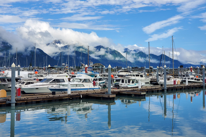
While the majority of visitors to Joshua Tree National Park stick to the pavement, there are several dirt roads that finger into the beautiful desert landscape, perfect for this Joshua Tree National Park motorcycle ride. (Photos by the author and Cheryl Kessel)
“It’s the Joshua tree’s struggle that gives it its beauty,” writes Jeannette Walls in her 2005 memoir The Glass Castle. She further contends that such struggle leads to growth and resilience. We motorcyclists know all about struggle, especially in the depths of winter. We struggle to find ways to assuage our overwhelming desire to ride as snow blankets roads and freezing winds cut like knives. For us, the Joshua tree can also represent escape and relief.
My wife and I sat in the morning sun in the courtyard of the beautiful Dive Palm Springs, a downtown boutique hotel in the vibrant California desert city (see sidebar below). As we ate croissants and fresh fruit, we discussed our January therapy session: riding our BMW G 650 XCountry through Joshua Tree National Park.
The ride out of Palm Springs was easy. The city has embraced and preserved its mid-century heritage and charm. Buildings, landscaping, and signage harken back to the city’s heyday as a mecca for L.A.’s rich and famous. We rode alongside expansive golf courses and tennis courts. Once out of the city, we continued east on Interstate 10 through the muted hues of the Mojave Desert.
Joshua Tree National Park has three entrances, and our route took us to the southernmost entrance near I-10. There was no wait at this lesser-used access, and our National Parks Annual Pass granted us entry.
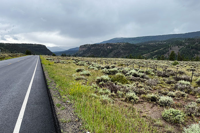
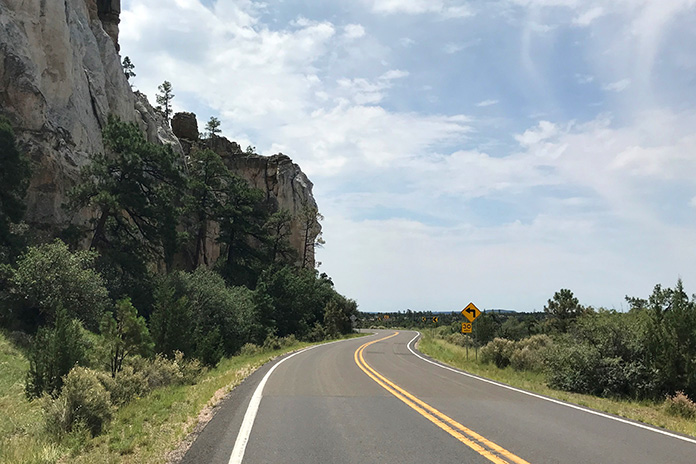
Our ride north into the park started as a nicely paved roll through the sparse desert landscape on Pinto Basin Road. Mountains rose on the horizon, but no Joshua trees. A full palate of cacti, including chollas and ocotillos, defined our early impressions of the national park. Long sweeping corners and smooth straight stretches marked the climb in elevation. The road became more curvaceous, and the park’s namesake trees started to appear sporadically, foreshadowing what was to come.
The author’s wife, Cheryl, stands in front of the park’s entry signage.
Pinto Basin Road terminates at Park Boulevard. A right turn would lead us north to Twentynine Palms, the city immortalized in a great Robert Plant song of the same name. Instead, we turned left into the heart of the park and the center of the Joshua tree universe.
The roads through Joshua Tree offer up starkly beautiful visual backdrops. The rock vistas, desert sand, and unique trees combine for a remarkable riding experience.
Almost immediately, the stands of Joshua trees became denser, the trees larger. Joshua trees are fantastical, whimsical, and majestic all at once. It is as if each one has a personality of its own. Some are simple and understated, but many are over-the-top in their stylized poses. Arms emanate in every direction and at rakish angles that seem almost comical, like attention-seeking adolescents with limbs akimbo and wild haircuts.
Our first pedestrian foray was at the fantastic erosion-sculpted Skull Rock. My diminutive riding companion could easily fit within one of the cranial cavities in the impressive monolith, one of many sculpture-esque outcroppings of granite in this portion of the park.
Cheryl stands in front of one of the park’s most recognizable features, Skull Rock. The rock morphs in appearance with the changing shadows throughout the day.
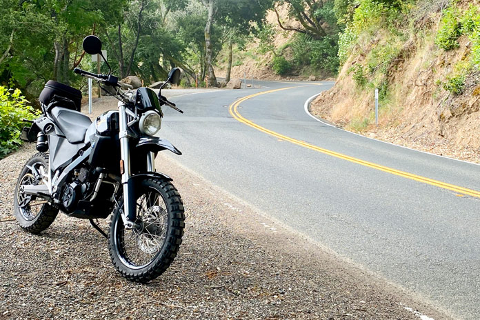
After a few more miles on our northwestern route through the park, we sampled one of the established dirt roads that wind through Joshua trees. Vehicles must stay on approved roads, and there are several dirt roads that offer off-pavement possibilities for dirt-worthy mounts. Our midsized BMW proved perfect for a little sandy exploration.
Back on tarmac, we motored past climbers scaling the vertical walls of beautiful rock formations. We also cut through the part of the park that features the most spectacular Joshua trees, which cast long shadows in the late afternoon light, adding an otherworldly quality to the ride.
After leaving the park, we rolled back to Palm Springs on Twentynine Palms Highway (State Route 62). We motored west and then south past Desert Hot Springs and beside a different forest – one of towering wind turbines. Back in Palm Springs, we showered off the day’s ride and headed downtown to enjoy the Palm Springs Village Fest, an event hosted every Thursday that features art, food, music, and lots of smiling attendees.
With our therapy session complete, we felt much better. This ride would be oppressively hot during the summer, but it’s the perfect escape in fall, winter, and spring months.
Dive Palm Springs is a quaint and beautiful 11-room boutique hotel on the fringe of downtown Palm Springs. The petite, Euro-inspired property is meticulously maintained, with a restored historic pool as its centerpiece. A welcoming glass of rosé greets new guests, and an individually prepared organic breakfast is delivered to your room or beside the pool each morning. This hidden gem is the perfect place to recline in luxury after a long ride.
Joshua Tree National Park Motorcycle Ride Resources
With 50 years of motorcycling and 30 years of teaching English under his belt, Tim Kessel has melded those two passions into a gig as a motojournalist. Maybe that’s why there is always a permanent, satisfied smile under his full-face helmet.
Greg’s BMW taking a dirt nap along the Oregon Backcountry Discovery Route. Photos by Greg Drevenstedt.
This story is about a ride that took place in 2013 on the original Oregon Backcountry Discovery Route, which was developed by the Oregon Off-Highway Vehicle Association. The nonprofit Backcountry Discovery Routes organization developed a new ORBDR that was released in 2023. For more information, visit the Backcountry Discovery Routes website. –Ed.
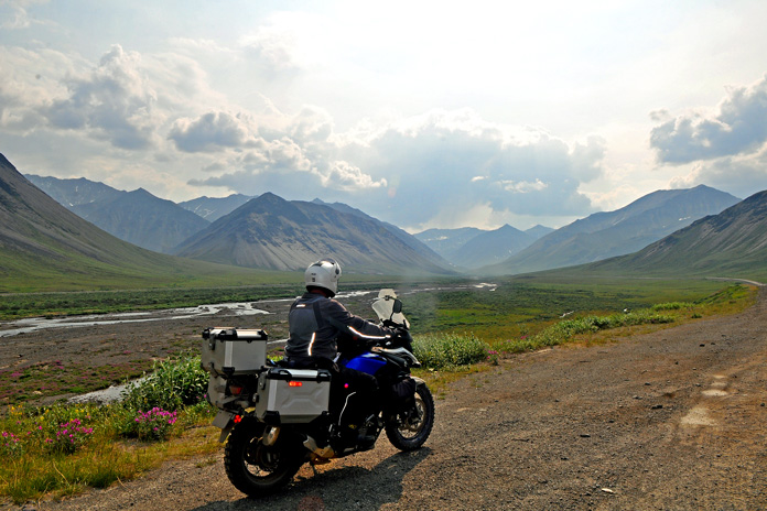
Route 5 of the original ORBDR includes hundreds of miles of gravel roads much like this one, plus a decent helping of dirt, sand, rock gardens, and river crossings.
When your bike topples over in the middle of nowhere, when your bike and its week’s worth of gear weigh more than 600 lb, when you’re hot and sweaty and tired, it’s good to have friends along to lend a hand.
At the California-Oregon border before venturing off-pavement on the ORBDR.
We were three days and nearly 300 miles into the 750-mile, California-to-Washington Route 5 of the Oregon Backcountry Discovery Routes (ORBDR), a network of off-road routes crisscrossing the state’s vast national forests. While struggling my way up a technical jeep road full of embedded rocks, I high-centered the BMW’s skid plate, dabbed my left foot into a hole, lost my balance, and toppled over in a big, dusty heap.
Lead rider Paul was off in the distance, so sweep rider Marten navigated around me, parked his bike on a level spot, and came back to help. Other than some badge-of-honor scratches on the bike, the only damage was to my pride, and I was soon making forward progress again.
Just a few miles into the ORBDR, we took a spur road to the summit of 8,000-foot Crane Mountain, where we enjoyed 360-degree views of California and Oregon.
Backcountry Discovery Routes is a nonprofit organization that establishes and preserves off-highway routes for dual-sport and adventure motorcycles. BDR has mapped and documented north-south routes in most states west of the Rockies as well as mid-Atlantic and Northeast routes and shorter BDR-X routes. Inspiration for these routes came from the ORBDR, which, according to BDR’s website, “was created a few decades ago by Bob and Cheryl Greenstreet as a concept to promote managed travel in the backcountry” and is maintained by the Oregon Off-Highway Vehicle Association.
The view from Fremont Point on Oregon’s Winter Rim.
Paul, Marten, and I wanted to ride the granddaddy of the Backcountry Discovery Routes, so I bought paper maps for Route 5 from OOHVA and Paul spent two weeks creating GPS tracks for us. (GPS tracks are now available upon request when maps are purchased from OOHVA.) Since most of the ORBDR is at 4,000-8,000 feet of elevation, we planned our trip for August to avoid snowpack.
A long-time adventure-riding and homebrewing buddy of mine, Paul Beck, is a computer guy. Since he created our tracks and led our group (his GPS was the only one that worked reliably), we dubbed him the Navigator. Marten Walkker, another riding buddy, is a master carpenter. He made his own tailbag, auxiliary gas tank, toolbox, and highway pegs for this trip, so we called him the Fabricator. And since I kept a journal, shot photos, and sent daily postcards to my wife, I became the Chronicler.
The Three Amigos at Fremont Point, 3,000 feet above seasonally dry Summer Lake.
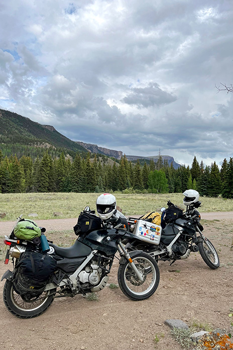
Similar in pace and temperament and always ready for a quick laugh, we were compatible travelers, like the Three Amigos. We were all of German descent and riding BMWs – Paul on an R 1200 GS, Marten on a G 650 Xchallenge, and me on an F 800 GS Adventure – so Drei Freunde is more accurate, but it doesn’t exactly roll off the tongue.
We had to cross the high desert through Christmas Valley to get from the mountains of Fremont National Forest to the mountains of Malheur National Forest.
Departing from Ventura on California’s southern coast, our first 750 miles were on pavement as we made our way up to the northeastern corner of the state. A half-mile before the Oregon border on the afternoon of our second day, we turned from U.S. Route 395 onto the unpaved County Road 2 and entered Modoc National Forest as we climbed into the Warner Mountains. We had to shift our brains from the grip and monotony of wide-open pavement to the delicate balance of riding top-heavy adventure bikes on loose, uneven dirt and gravel. The road leveled out within a few miles, and we turned north, passing through the green meadows of the (not so) Dismal Swamp and crossing into Oregon.
River crossings are nerve-racking with an audience of forest service workers, but Marten made it through like a pro.
After riding a challenging spur road up to the top of 8,000-foot Crane Mountain for panoramic views and navigating through a herd of cows, we stopped at Willow Creek Campground, which was deserted. We crossed a cattle guard to get into the campground, and even though it was surrounded by a fence, we still had to pick our way through a minefield of cow patties to set up our tents. After bathing and rinsing out our sweaty clothes in the creek (but not drinking the water), we fortified ourselves with backpacker meals and relaxed around the campfire, swapping stories and sipping whiskey.
Cooling off in Delintment Lake in Malheur National Forest.
The OOHVA’s detailed, full-color ORBDR map booklets offer the following words of advice: “Your journey will be one of few contacts with others. One needs to plan for being self-sufficient. Travel with others is highly recommended. If one’s means of transport fails, it can be a really, really long hike, and it could be many days before someone comes along.”
The early bird gets to enjoy the sunrise.
Over the course of five days on the ORBDR, we saw only a handful of people – a few ranchers, a couple of 4×4 trucks, and the occasional hunter. We traveled as a group, each of us brought our own food, water, and gear, and we carried a SPOT satellite tracker/communicator. Gas was available every 100 miles or so, often in small towns or at convenience stores near the route, and we filled up our tanks and hydration backpacks at every opportunity.
Lunch stops at local cafes provided welcome relief from the hot, dusty trail.
“Much energy has been spent to provide you with maps that provide the information needed to successfully navigate without on-ground signs,” says the OOHVA. We saw only a few faded, old ORBDR signs over the entire 750-mile route.
“The development of route was financed by the Oregon ATV Allocation Funds,” said Leonard Kerns, president of the OOHVA, in a blog on Touratech-USA’s website. “On-the-ground signs were placed and the route was dedicated in the summer of 2000. Unfortunately, it did not take long for people opposed to the route to bring legal action. Support from the Forest Service and Bureau of Land Management was lost and all remaining funds were used to remove the signs. At that point, OOHVA stepped in and created the maps using GPS to navigate.”
Breakfast of champions.
The ORBDR is on public land, so anyone can travel the route using a street-legal vehicle, but much of it passes through areas used for grazing and logging. We crossed dozens of cattle guards and stopped often to open and close barbed-wire gates. Forest land in central and eastern Oregon is all but empty, yet it’s crisscrossed with so many access roads that without GPS tracks and paper maps, getting lost is all but assured.
Even with GPS tracks, sometimes we hit dead ends and had to find a way back to the correct trail.
One of several massive fallen trees we had to navigate around since going over wasn’t an option!
The OOHVA’s maps were created in 2002, and in the years since, some roads have been closed and new ones have been cut. Even following the purple line on Paul’s GPS, we still made wrong turns or hit dead-ends and had to figure out how to re-route ourselves. We also encountered the unexpected, such as fallen trees and man-made barricades. Therein lies the adventure. Riding a backcountry route is not like following the Yellow Brick Road; it requires not only preparation and riding skills but also teamwork, patience, and adaptability.
Being far from anywhere, we had campgrounds largely to ourselves and were fortunate to have either a stream or lake nearby.
We quickly established a routine: waking early to heat up water for coffee and oatmeal using portable stoves, breaking camp, riding for several hours, stopping for lunch and gas, riding for several more hours, then stopping early to set up camp and relax. Paul was always in the lead, which meant his gear stayed clean and we had someone to blame for wrong turns. I followed Paul and Marten followed me, and even with space between us the dust filled our noses and covered our gear, making zippers and buckles hard to open and close. We planned to camp every night, but it didn’t work out that way, to our surprise and benefit.
Lead rider Paul stayed clean; sweep rider Marten stayed dirty.
During our five days on the ORBDR, we experienced a steady stream of good luck. We enjoyed mostly warm, dry weather and had no flat tires, breakdowns, or injuries. Rather than eating jerky and energy bars for lunch, we usually found a cafe in a small town where we’d refresh ourselves with air conditioning, limitless iced tea, and other luxuries, and there was always a gas station nearby to fill up and resupply.
We smelled smoke but had no idea the 1,000-acre Vinegar Fire was burning in the area until we popped out of the trees and came upon this U.S. Forest Service fire security truck. Our route was supposed to go down that gravel road in the distance, but we were re-routed onto pavement to the town of Ukiah.
During the three nights we camped, there was either a cool stream or a lake we could swim in to wash off the dust and relax our creaky joints. On our second day on the ORBDR, after a challenging, tiring section with lots of sand and rocks, we ended up in the town of Christmas Valley, where the Lakeview Terrace motel/restaurant spoiled us with cheeseburgers, fries, cold beers, hot showers, and soft beds.
Antlers Inn in Ukiah has a room-size meat cooler to store your game.
Even when we had to leave the ORBDR to route around the 1,000-acre Vinegar Fire, we got to ride 50 miles on the freshly paved Blue Mountain Scenic Byway and ended up in Ukiah on a damp, foggy night. Instead of pitching tents and eating freeze-dried meals in the rain, we stayed warm and dry at the Antlers Inn and savored burgers and beers at the Thicket Cafe & Bar. We enjoy roughing it, but we’re not too proud to take advantage of good fortune when it lands in our laps.
Chris ran the Antlers Inn and served us at the Thicket Cafe & Bar, where she recommended an Oregon-distilled whiskey.
Our five days and three nights on the ORBDR provided us with as much adventure as we could hope for. We rode more than 700 miles on dirt and gravel roads through the backcountry of Oregon, through dense forests, across high-desert plains, along mountain ridges, away from cities and people and normal obligations. We rode through rock gardens and sand washes, forded rivers, and navigated over or around countless obstacles, challenging ourselves and having fun. We had campgrounds to ourselves, where we enjoyed star-filled nights and soul-warming campfires, and we stumbled upon cozy motels and restaurants, where we enjoyed creature comforts.
We were treated to some of the best scenery of the ORBDR, such as wide-ranging views from Kendall Skyline Road in Umatilla National Forest, on the final day.
Paul, Marten, and I – the Navigator, Fabricator, and Chronicler – bonded over the experience. When we reached Walla Walla, Washington, the northern terminus of the ORBDR, having ridden 1,500 miles together, we high-fived and celebrated our shared accomplishment. The next day we headed off in different directions, Paul to Seattle, Marten to Calgary, and me home to Ventura, completing an Iron Butt SaddleSore 1000 in the process, but that’s another story.
After five days and 750 long-and-dusty, not-so-straight south-to-north miles, we completed Route 5 of the ORBDR and arrived in Walla Walla, Washington.
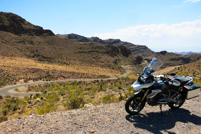
Riders enjoy the winding asphalt on this Route 66 motorcycle ride outside of Oatman.
Route 66, or the Mother Road, is indelibly stitched into the fabric of the American psyche. The iconic road once traced its way for 2,448 miles from Chicago, Illinois, to Santa Monica, California. But it was more than just a long stretch of tarmac. Route 66 became a cultural phenomenon that inspired and piqued the American obsession with travel and adventure. Songs were written about it, quirky and kitschy roadside attractions sprouted beside it, and Americans longed to traverse it. The Mother Road was a main artery crossing the torso of the U.S. through which dreams and possibilities pulsed warm and red.
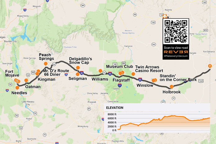
Yearning to rediscover the road, the towns, and the magic of Route 66’s path through Arizona, I packed up my BMW R 1200 GS and set out. Fittingly, my trek began Nov. 11, the date on which the Mother Road was designated a federal highway in 1926. Arizona claims the longest rideable portion of the original Route 66, and it has a significant number of attractions and bustling historic towns.
Riding from west to east, I began my Mother Road adventure on the Fort Mojave Indian Reservation where the Colorado River separates Arizona from Nevada. After a short climb toward the mountains on Boundary Cone Road, I came to an intersection indicating that I was transitioning onto the historic U.S. Route 66. The road became curvier and more interesting, and the jagged rock formations of Arizona’s Black Mountains became more immediate as the road coiled through the rugged terrain.
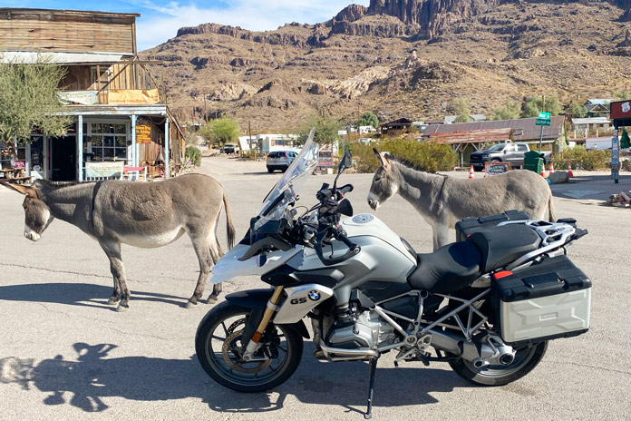
Friendly burros in Oatman weren’t impressed with my BMW beast of burden.
Within minutes, I entered the historic mining town of Oatman. In 1915, two miners struck a $10 million gold find. Within a year, the small mining camp grew to a population of 3,500. Recent census figures indicate there are now just over 100 human residents. If you include the dozens of semi-wild burros in the area, that population is much larger.
Oatman is a hotbed of activity during any motorcycle rally on the Colorado River or in Kingman. However, my BMW was one of only two motorcycles in town on this crisp November morning. I walked the street beneath the weathered wood facades of the various shops and watering holes.
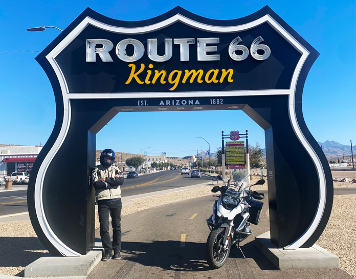
This ride-through photo stop in Kingman is located next to the Arizona Route 66 Museum.
Route 66 north and west of Oatman is a pure delight. The pavement is mostly smooth and intact, and it’s filled with sweeping turns and hairpins, many of which are nicely banked. There are several signs warning motorcyclists to stay aware, and these are best heeded. With the road gradually uncoiling, I made my way toward Kingman, passing several abandoned open-pit mines that dotted the rocky slopes and at least one small operating mine.
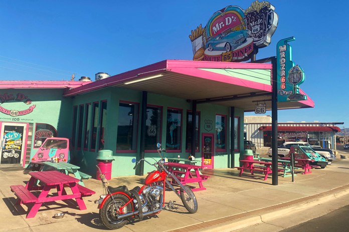
I was ready for a cup of coffee and some gas when I rolled into Kingman, where my father was an art teacher in the local school district before I was born. It is a clean and bustling small city fully embracing its Route 66 roots. I stopped at the colorfully adorned Mr. D’z Route 66 Diner and parked amidst historic cars, trucks, and motorcycles. As I chatted with my server over a hot cup of joe, she talked about the dual nature of the city. We were in the historic downtown district, but just a little ride up Interstate 40 is the modern district with chain hotels, restaurants, and thriving industry.
Across the street from the Route 66 Kingman sign is Mr. D’z Route 66 Diner, one of the many kitschy restaurants along the Mother Road that draw in curious, hungry travelers.
After rolling through the industrial zone in the Kingman outskirts, I headed northeast on the longest existing stretch of the Mother Road. Small roadside businesses dotted the path toward Peach Springs, each clearly embracing its Route 66 heritage with appropriate signage and vintage memorabilia. Historic gas stations were particularly interesting. While they no longer pumped fuel, they still oozed with the nostalgia of the road’s heyday.
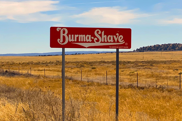
Between Peach Springs and Seligman: You can drive / A mile a minute / But there is no / Future in it / Burma-Shave.
After Peach Springs, I rode past three sets of Burma Shave signs with rhyming slogans, reminding me of childhood. As I rolled and swayed through the high grasslands, it was easy to imagine classic cars and motorcycles plying this portion of the route.
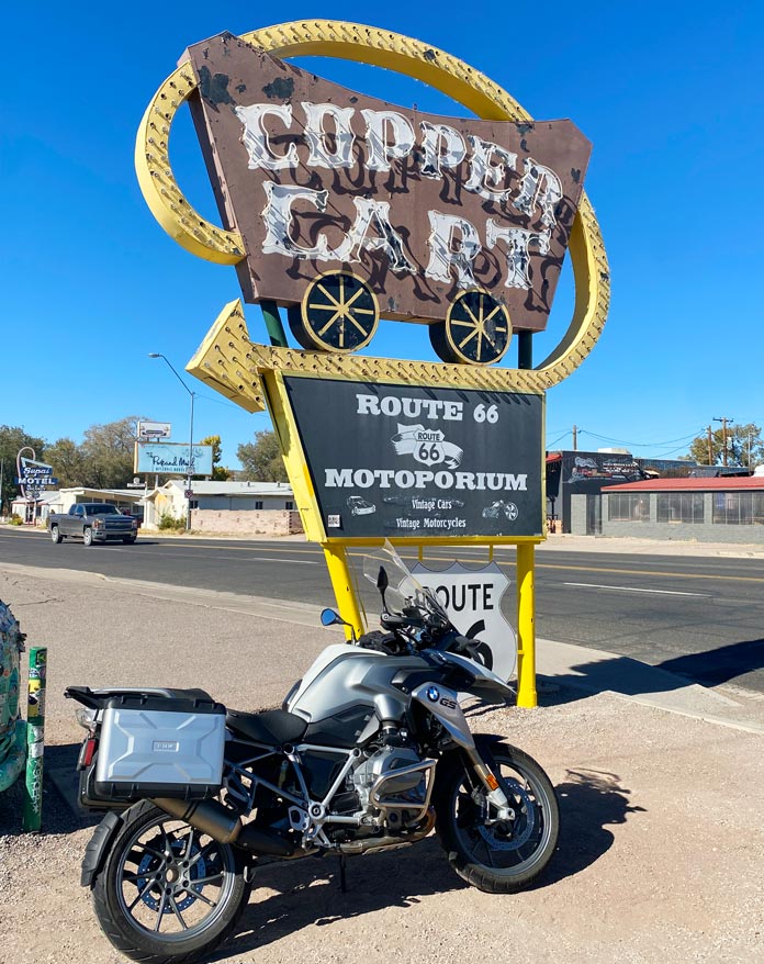
Formerly a restaurant that opened in 1952, the Copper Cart in Seligman is now a gift shop.
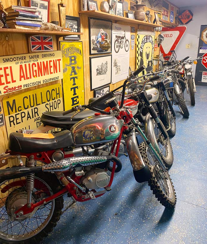
Entering Seligman was the most visually nostalgic part of my ride. This small town is a well-preserved tribute to its Route 66 heritage, with every shop, garage, and diner adorned with colorful signage and logos. Out of the corner of my eye, I saw a small sign for the Route 66 Motoporium. Not expecting much, I threw down my kickstand and walked into the Copper Cart to see what was inside. A bearded man said, “You look like a rider,” and pointed to a room in the back. It was filled with the motorcycles of my youth – both those that I rode and those that I ogled in the pages of motorcycle magazines of the 1960s and ’70s. Vintage Indians, Hondas, Hodakas, and Kawasakis, especially the 2-strokes, brought me back to the enchanting smell of premix laced with single-track dust that was a big part of my teenage life.
The Copper Cart in Seligman is home to the Route 66 Motoporium, a small museum full of vintage motorcycles and memorabilia.
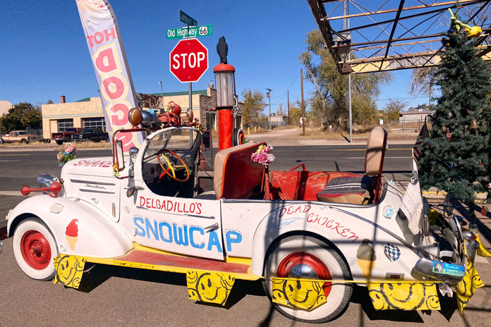
After a lengthy trip down moto-memory lane, it was time for lunch, and the legendary Delgadillo’s Snow Cap diner was just a block away. Juan Delgadillo and his wife, Mary, opened the Snow Cap in 1953, and Juan and his brother Angel formed the Historic Route 66 Association of Arizona. The Delgadillo family still owns and runs the historic diner, and I had a fantastic green chili burger and onion rings.
This 1936 Chevy is an eye-catching fixture in front of Delgadillo’s Snow Cap diner, a Route 66 institution in Seligman opened by Juan and Mary Delgadillo in 1953.
East of Seligman is a short stretch of the original Route 66 that runs into I-40 just before Ash Fork, and I noticed a few remnants of the Mother Road that are now spurs off the roadway. Beyond Ash Fork, much of Route 66 has been fully replaced with I-40, but there are still several towns that have embraced and preserved their historic Mother Road character.
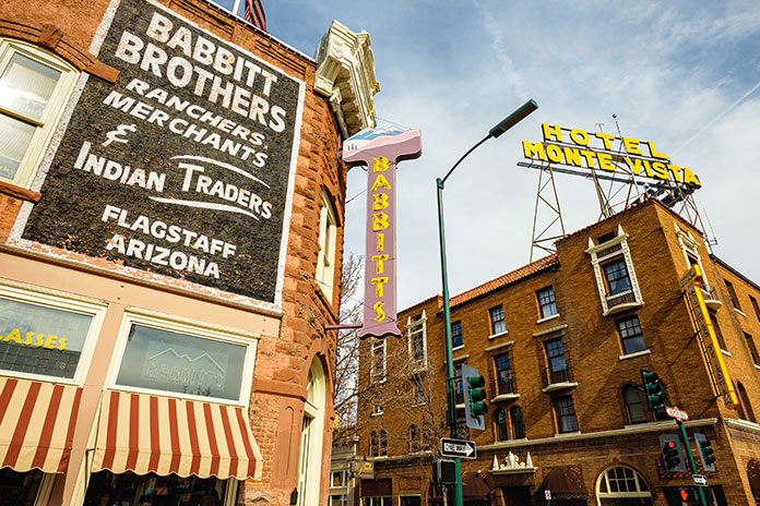
Route 66 runs through the heart of Flagstaff, a bustling city with great restaurants, bars, hotels, and nearby attractions like the Grand Canyon.
Williams, just off I-40, was the last town to be bypassed by the interstate, and it still teems with Route 66 charm. The main street is lined with historic stone buildings filled with antique stores, diners, and bars. I motored by one of the more famous watering holes, the Sultana Bar, which was opened in 1912, predating Route 66 by more than a decade.
After Williams, I-40 is as attractive as an interstate can be. Views of the San Francisco Peaks tower impressively to the north, and vibrant evergreens line the road. Flagstaff is the largest city on the Arizona portion of Route 66 and is home to my alma mater, Northern Arizona University. The original Route 66 skirted the beautiful campus just to the west and north.
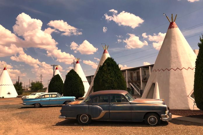
Built in 1950, the Wigwam Motel in Holbrook is a Route 66 icon.
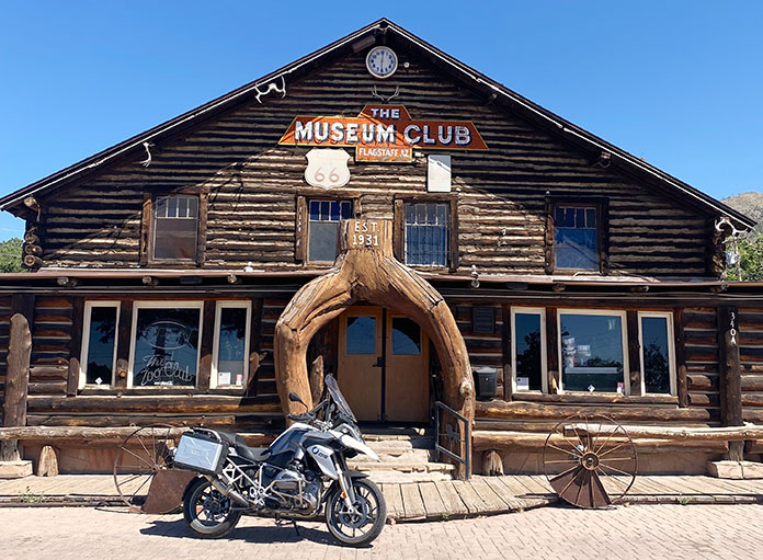
Flagstaff boasts several original Mother Road attractions, including the historic downtown train station that houses the Flagstaff Visitor Center. On the way out of the city, I rolled past several diners that boast the Route 66 name, but my favorite is Miz Zip’s Route 66 Cafe. Then I felt the magnetic pull toward the Museum Club, an iconic Route 66 watering hole and one of my favorite college hangouts.
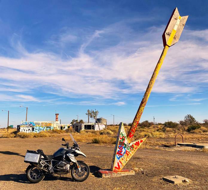
The majority of Route 66 east of Flagstaff has been replaced by I-40. While that is a shame, there is solace in the fact that many of the original attractions of the Mother Road era are still partially or fully intact on the way to the Arizona/New Mexico border. I took the short access road to the ruins of the Twin Arrows Trading Post. Up until very recently, both twin arrows still stood, but the ravages of weather and time toppled one. The trading post was a fixture on Route 66 since its opening in the late 1940s. Just across the freeway looms the new Twin Arrows Navajo Casino Resort.
Alas, only one arrow is still standing at the ruins of the Twin Arrows Trading Post between Flagstaff and Winslow.
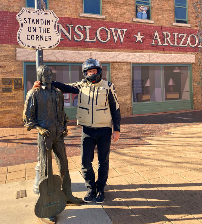
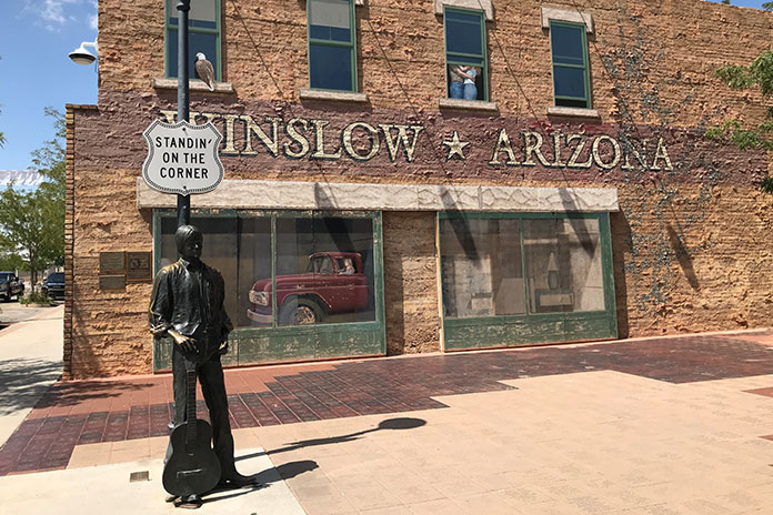
Riding another 30 minutes east on the interstate, I exited at Winslow, which sits on another existing stretch of Route 66. The loop into Winslow is festooned with various Route 66 advertisements. My first stop in town was to look at the impressive red sandstone St. Joseph’s Catholic Church. After snapping a photo at Standin’ on the Corner Park, I saddled up and headed to my lodging for the night, the beautifully restored La Pasada Hotel (see sidebar below).
At Standin’ on the Corner Park in Winslow, Arizona, the author stands with a bronze statue of a balladeer resembling Jackson Browne, who co-wrote the famous Eagles’ song “Take It Easy” with Glenn Frey.
After settling into my room, I walked the grounds of the beautiful rail-side resort before sitting with a post-ride cocktail and watching the trains roll by. Later that night, I strolled back into downtown Winslow for some shopping and a chili relleno dinner at the tiny Brown Mug Cafe. An unassuming photo on the wall beside my booth showed a youthful Harrison Ford sitting in the same spot many decades back (he’s an avid motorcyclist, by the way, and also owns a GS!).
Some motorcycles you’ll find on Route 66 have seen better days.
After a great night’s sleep, I had one last stretch to complete my Arizona Route 66 tour. I rode the few miles to Holbrook, which is the last of the original historic towns on my eastward stretch of Route 66 and home to the Wigwam Motel. From Holbrook, it’s another 74 miles on I-40 to the New Mexico border.
I highly recommend riding what you can of any portion of the Mother Road. This Arizona stretch of Route 66 is best ridden from late spring to early fall, as the winters in northern Arizona are cold and snowy. Pack for variable conditions, and enjoy your ride down memory lane.
La Posada in Winslow is a crown jewel of the historic Fred Harvey railroad hotel empire. Designed in the 1920s by renowned architect Mary Elizabeth Jane Colter, it’s currently a first-class hotel, art gallery, and museum in an expansive garden setting. There is a gourmet restaurant on-site, and downtown Winslow is a short stroll away. The rooms are comfortable and well-appointed in a warm Southwestern motif, and photos of the hundreds of legendary actors and public figures who stayed at La Posada line the hallways. There is even safe designated motorcycle parking in front of the property. For more info, visit the La Posada website.
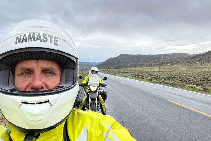
On the Dalton Highway, Sukakpak Mountain rises 4,390 feet and reflects in the Koyukuk River. Sukakpak is an Iñupiat word meaning “marten deadfall” because, seen from the north, the peak resembles a carefully balanced log used to trap marten. (Photos by the author)
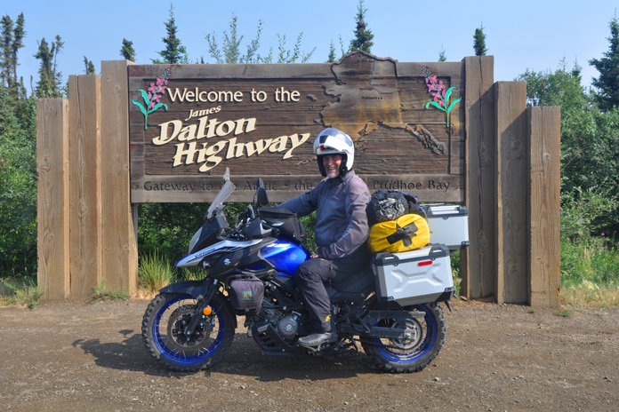
It wasn’t that she was a princess. She had lived and taught on a reservation in northern Ontario where she gutted geese, chopped down trees, and drove on the ice roads. But by her own admission, my partner, Steph, was a sun ‘n’ sand type of vacationer. Riding and wild camping with no electricity was not her idea of a good time. And a hostel? Forget it. So when the opportunity arose for an Alaska motorcycle ride – taking my Suzuki V‑Strom 650 from Niagara Falls to America’s last frontier – my suggestion that she fly to Anchorage and meet me…well, it wasn’t flying.
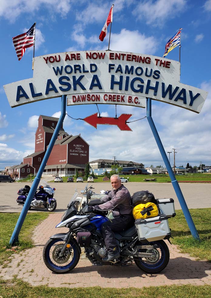
Built by the U.S. Army for defense from the Japanese in WWII, the Alaska Highway opened the secluded northwest to travel and trade. In the background, the only wooden grain elevator remaining in Dawson Creek, British Columbia, reopened in 1983 as an art gallery.
But over the weeks – and from over my shoulder – the more she saw of my reading and planning and YouTube videos, the more curious she became.
My late June ride across the Canadian prairies and into northern British Columbia had been an adventurous mix of wind and rain and heat so unbearable that I spent a full day in a rundown Saskatchewan hotel to recover in air‑conditioned bliss. But it wasn’t until I reached the Alaska Highway west of Haines Junction, Yukon, that I began to wonder if my riding skills would be up to the task.
The entire 200 miles to the Alaskan border was a constantly changing mix of gravel, chipseal, and potholes, with just enough pavement to inspire complacency. Most disconcerting were the unannounced depressions caused by permafrost. Without warning, the bike would simply drop away beneath me, only to come pounding back like an unbroken bronco. Twice I was certain I was going over the handlebars. Almost as unnerving were the lengthwise ridges that attempted to grab my tires and toss me off the road.
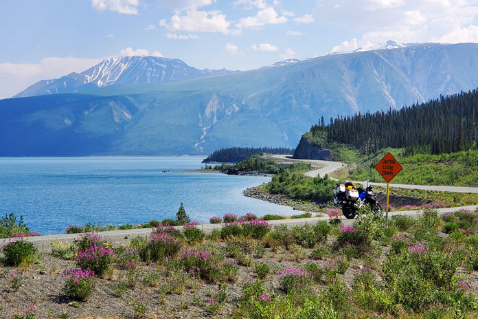
The Alaska Highway threads its way between Kluane Lake and the Kluane Mountains near Destruction Bay, Yukon. The entire 200 miles from Haines Junction to the Alaska border was an adventure in itself.
Between the irregular road surface and the wildlife, I was in no danger of nodding off. At one point, I was negotiating a corner on the loose surface when a large moose bolted into my path from the alders on my right. Brakes were almost useless in the gravel. She was so startled that she was still peeing as she charged in front of me, and I admit I checked myself for the same once she had disappeared into the brush. It wasn’t long before I encountered a grizzly and then a caribou on the shoulder, but they at least seemed content to stay put.
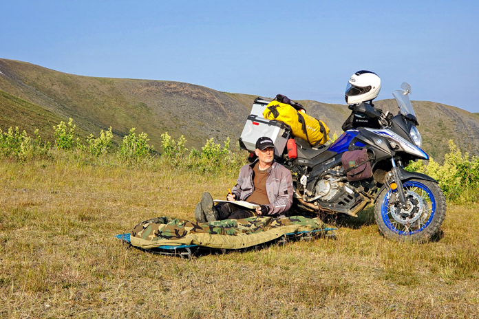
Wild camping on the Top of the World Highway near Poker Creek, Alaska.
The pavement improved measurably near Tok. In Yukon River Camp, where I fueled up for the long ride on the Dalton Highway to Prudhoe Bay – one of the “most dangerous roads in America” – I partnered up with another solo rider for mutual support should the trip go (quite literally) sideways. With no shoulder and with roadsides that often plummet 50 feet to the soggy tundra, one of the greatest dangers of the Dalton is unexpectedly becoming the focus of a search party. But the weather gods smiled on us. A sprinkling of rain the day before had dampened the notoriously blinding dust without creating the slippery, muddy mess I had feared. And I marveled at the midnight sun, which kept temperatures between 35 and 60 degrees.
While camping on the Top of the World Highway near Poker Creek, Alaska, the author was awakened by an enormous herd of Porcupine caribou passing by.
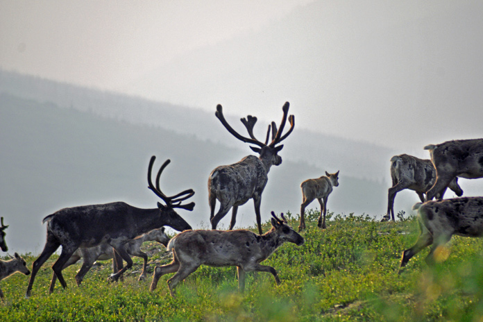
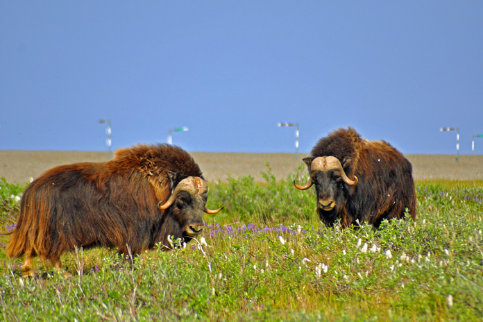
After a night of primitive camping – and a surprisingly good meal – in Coldfoot, my riding partner and I spent a full day navigating the dirt and ogling the views: from the omnipresent Trans Alaskan Pipeline to the enormity of the Brooks Mountain Range and Atigun Pass, to the endless sweep of tundra on the North Slope toward the Arctic Ocean. And of course, the muskoxen we encountered as they munched on moss and lichens. Needless to say, high‑fives and a toast were in order two days later when we successfully returned to Fairbanks. This was adventure on a new scale.
Just east of the Dalton Highway (aka the “Haul Road,” which runs from just north of Fairbanks to Prudhoe Bay), muskoxen roamed the windy tundra of the North Slope near the Sagavanirktok River. They live naturally only in the Canadian arctic tundra, Alaska, and Greenland. Members of the goat family, their underwool is eight times warmer than sheep’s wool yet surprisingly light.
Rolling into Anchorage, on the other hand, I was struck by how much the city was like any other. In fact, locals joke that the best part about Anchorage is that in under an hour, you can drive to Alaska. I searched out the House of Harley‑Davidson, which offers riders free camping (including restrooms and showers), and awaited Steph’s arrival.
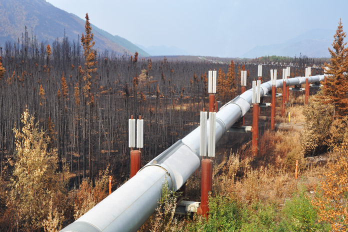
The Trans Alaska Pipeline runs 800 miles from Prudhoe Bay to Valdez, a port near the Gulf of Alaska, and was engineered to shift with the permafrost, withstand forest fires (as it has done here), and adapt to temperature changes of 180 degrees F (the pipeline lengthens by almost 6 feet in summer heat).
It was a little discouraging the next morning when her flight brought with it a cold front full of clouds and rain. But I was grateful she had come and determined to make the most of our 10 days together. On the way to Flat Top Mountain for a panorama of the city, we rolled along Cange Street, which doubled as an airport runway. Each home had its own attached hangar, and prop planes were parked on several front lawns. On another city corner, we encountered a moose that casually browsed a willow before sauntering across a driveway and into a backyard.
Staring down the Dalton: Is that a smile or grimace?
South of town, the Seward Highway hugged the narrow shore between the steep Chugach Mountains and the churning waters of Turnagain Arm. At Beluga Point, we paused to watch the tidal bore, a daily surge of seawater that can be over 3 feet high and sounds like a freight train. The tides themselves, rising to 35 feet, rival those of the East Coast’s Bay of Fundy. Naturally, we had to visit the nearby Alaska Wildlife Conservation Center where injured animals are rehabilitated. It was one place where we were guaranteed to see most of Alaska’s wildlife up close.
Seward Boat Harbor, on Resurrection Bay, is merely an introduction to the beauty in store on the Kenai Peninsula.
Believing that my intrepid partner deserved at least one nice hotel, I had booked a “glacier view” suite in the port of Whittier. This came with the bonus of riding through North America’s longest tunnel, a single‑lane route that runs 2.5 miles under an entire mountain. Besides a fish-processing plant, however, Whittier has only two large buildings, both of which are remnants of World War II: an abandoned military supply post and an apartment building that houses nearly the entire town’s population. Without even a pretense of renovations, the top floor now serves as a hotel.
Our apartment, while clean, was clad in 1960s paneling, and the bathroom was adorned floor‑to‑ceiling in pink tile. Most bizarre was the multitude of safety bars (I counted 10) fastened to the wall in the shower. Steph had started calling it the “Bates Motel,” and I suggested the handles were for grabbing when Norman dropped by. On top of that, not only was the rain incessant and obscured the view of the harbor from our window, but when we asked about the glacier, we were told we’d have to sail 6 miles out of port and around a mountain to get a glimpse. Alaskans also joke that “Everything is sh*ttier in Whittier,” and we just had to laugh.
Wading into the icy waters of Prudhoe Bay on the Arctic Ocean.
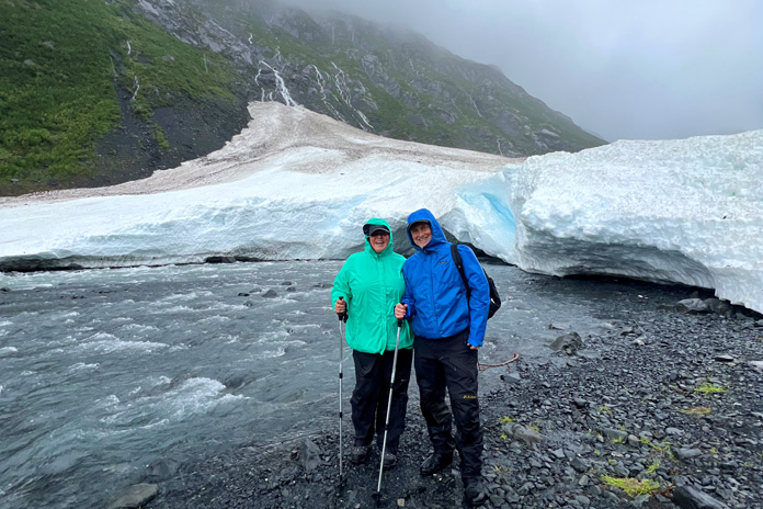
However, if our night had been a low point, the next morning was a decided high. Wearing our raingear and carrying a set of hiking poles, we set out to explore Byron Glacier. Dense forests gave way to alder thickets that soon opened to lichen‑dotted boulders. Under a steady rain, we climbed the rugged upper valley where ice lay covered in black silt. Towering high above, the jagged peaks were trimmed in white fondant while sinuous waterfalls tumbled from the sheer cliffs. Ahead, shining and motionless, the bright blue glacier stood before us, a frozen river imperceptibly carving out the valley floor. Dwarfed in this vast, timeless amphitheater, we seemed no more than fleeting specks, and tears welled up in Steph’s eyes. This was travel on a new scale.
After a cozy night in a warm log cabin, we continued to Seward where we joined a day‑long boat tour of Kenai Fjords National Park and Resurrection Bay, a rich marine ecosystem with craggy coves, deep fjords, and tiny treed islands. Every wildlife sighting brought a new gasp: Sea lions, otters, puffins, murres, and mountain goats were but a prelude to the humpbacks, fin whales, and orcas. Bald eagles watched us from branches along the shore.
Approaching Atigun Pass from the north on the Dalton Highway, the author pauses beside the Sagavanirktok River.
Most stunning of all was Northwestern Glacier at the head of the fjord. As a million tiny ice chunks bobbed around our boat like warning buoys, we drew ever closer and were overwhelmed by its size and the thunderous calving. The splitting columns sent booming explosions reverberating off the cliffs, followed by great walls of ice crashing into the frigid water. We stood gripped in a hallowed silence.
Arriving in Palmer the following day, we explored the Matanuska Valley, a region with a surprising claim to fame. Particularly fertile soils and summer days with 22 hours of sunlight produce record‑setting vegetables: cabbages bigger than beach balls, carrots the size of small logs, and pumpkins that must be lifted by crane. As one resident told me, “We get just as much sunlight as anywhere else – we just get it all at once.”
The author and his partner, Steph, hiking Byron Glacier.
Along the Knik River, we were introduced to glamping in a huge canvas tent with a queen‑sized bed, an upholstered chair, and more pillows than a palace. It was a far cry from my bivy sack – and just what Steph had wanted.
Morning was a little brighter as we set off for Homer, a small town on the southwest side of the Kenai Peninsula. Twisting through wooded Cooper Landing and Soldotna, the Sterling Highway turned south and followed the coast along Cook Inlet. From Clam Gulch, we skirted the edge of the cliffs all the way to our destination. When keeping my eyes on the road became impossible, we pulled over and tramped through a field to the precipice, where we could see Sadie Peak across sparkling Kachemak Bay standing in snow‑covered glory high in the equally glorious Chugach Mountains.
Northwestern Glacier is one of many photo ops at every turn in Kenai Fjords National Park.
The only thing I knew about Homer was that the Salty Dawg Saloon was perched on the end of a spit. As old as the town itself, the diminutive building has served as a school, post office, railway station, and grocery store. In 1957, it became a saloon, and shortly thereafter, as the story goes, a patron who’d grown tired of waiting for his friend stuck a dollar bill to the wall for him to buy a drink if he ever showed up. The ensuing tradition has resulted in every surface being completely papered in dollar bills. Unable to find room for my own bill, I wedged a Loonie (a Canadian dollar coin) into a picture frame and apologized (equally Canadian) to the bartender for my 76‑cent contribution.
Thirty minutes east of Homer, we bounced down a rutted dirt road to our accommodations on the Kilcher Family Homestead. In the early 1940s, professor Yule Kilcher left war‑torn Switzerland to find peace in the wilds of Alaska, where he and his wife built a log cabin and raised eight children. Living a subsistence lifestyle and clearing fields, the family eventually acquired 600 acres, where they continue to live off the land.
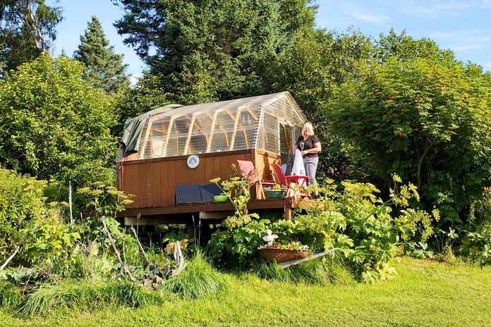
Stellavera’s garden-shed-turned-lodging on the Kilcher Family Homestead.
You have undoubtedly heard the music of Jewel, one of the Kilcher grandchildren, and may even have seen episodes of their Discovery Channel series, Alaska: The Last Frontier. One daughter, Stellavera, lives off‑grid in a yurt near the cliffs and converted a garden shed into a surprisingly enchanting Airbnb. Enclosed in clear corrugated roof panels and furnished with a queen bed, heater, and lots of books, the structure – and the outdoor shower – gave us stellar views of Kachemak Bay and the ice‑glazed mountains beyond. It was spectacular.
Before we knew it, we had to return to Anchorage, where I needed to do some scheduled bike maintenance and Steph caught a flight home. The weather had deteriorated the day she arrived, and although it never kept us from the many activities we had planned, we joked that the sun would return the day she left. That is exactly what happened. Under a clear blue sky, I rolled out my bivy again, anticipating the next leg of the journey and happy to have spent 10 days with Steph in a land unlike anything we had ever known. She still loves the beach, of course, but now all she can talk about is when we can go back to Alaska, where wonder is on a new scale.
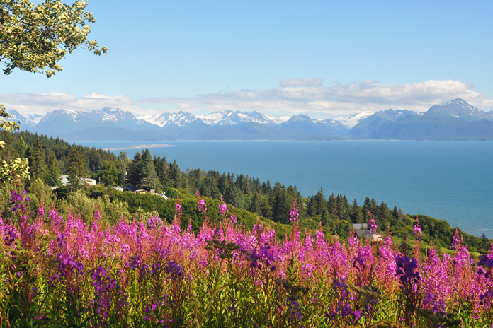
Fireweed adds vibrant color to the cliffs facing Sadie Peak on the far side of Kachemak Bay near Homer.
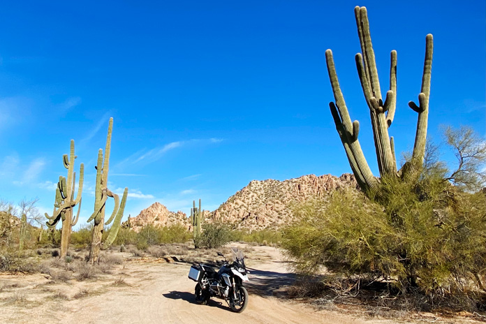
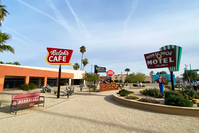
Nothing says “Arizona” like tall saguaros. These thorny towers are in the Sonoran Desert National Monument.
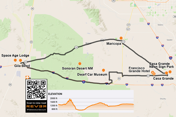
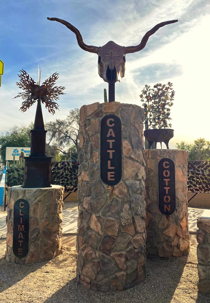
Arizona is known for its five Cs – copper, cattle, cotton, citrus, and climate – all of which are represented on the state’s great seal. I experienced three of them in abundance on this scenic southern Arizona loop, rolling past harvest-ready cotton fields and large dairy farms and enjoying spectacular weather. Two more Cs – cactus and cars – were also highlights of this entertaining ride.
Before you get the wrong impression from the title, I did not get locked up on this trip. “Big house” is the English translation of the Spanish “Casa Grande,” the starting and ending point of this loop ride. My trip began with a walk around the city’s downtown, which includes a tidy and interesting neon sign park, a nicely curated museum, a city park, and an impressive city square. Every January, the annual Historic Downtown Street Fair/Car and Bike Show draws upwards of 40,000 visitors to Casa Grande.
A roadside display in Casa Grande highlights some of the state’s foundational Cs.
After the stroll, I mounted my BMW R 1200 GS for the short ride to the Francisco Grande Hotel and Golf Resort. Tall palm trees stood sentinel as I rolled onto the resort’s beautiful property, which was established in the early 1960s as the spring training home of the San Francisco Giants. It was also a favorite haunt of John Wayne. After settling into my room and enjoying the incredible view, I had a delectable burger in the Duke’s Lounge and admired photos of Wayne, Willie Mays, Pat Boone, and other legendary visitors.
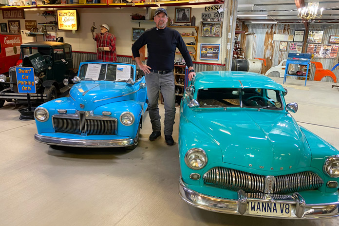
After a great night’s sleep, I mounted my GS and rode west through cotton fields and dairy farms to my first stop, the Dwarf Car Museum. The unassuming cluster of buildings belies the treasures displayed within. I paid my $5 entry fee and walked inside. At first glance, I could have been in any cool classic car museum, but as I got closer, the cars seemed to shrink.
The stunning and diminutive creations in the Dwarf Car Museum sit waist-high to the 6-foot-3 author. In addition to small cars, the museum also has an interesting collection of automotive memorabilia.
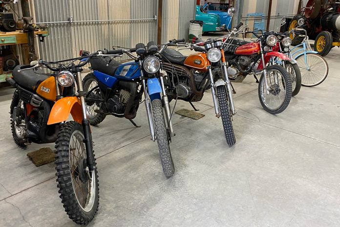
After scanning the whimsical, barn-like interior of the museum, I spotted a gentleman warming himself by a fire in the perfect man cave. Ernie Adams, the master builder of this eclectic and fascinating collection of diminutive classics, invited me to have a seat, and we had a nice chat about his life and his cars. Adams built his first dwarf car in the early ’60s, and they are about 11/16th scale. He bases every creation on a wheel size of 12 inches and miniaturizes everything else to that scale. Adams does not do much of the work anymore, but his son, daughter-in-law, and a friend carry on the tradition. He even has a tidy collection of vintage enduro bikes in a backroom.
What gearhead doesn’t have a soft spot for vintage Japanese dirtbikes?
Back on the GS, it was time to head to another C: the cactus-rich majesty of the Sonoran Desert National Monument, one of the most biologically diverse deserts in North America. Saguaros tower over the sand, each striking their own unique pose. With the rugged South Maricopa Mountains serving as the perfect backdrop, I explored a few established dirt roads off State Route 84.
On Interstate 8, I opened the throttle and made my westward ride through more of this desert grandeur. Interstates have never been my choice of roads, but this stretch of I-8 is as beautiful as they come. Various cactus varieties dot the rolling hills in the foreground, and distant mountain ranges create texture in the background.
The Casa Grande Neon Sign Park in the city’s downtown area preserves vintage neon signs from historic local establishments.
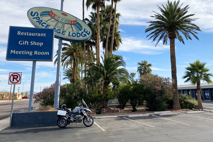
The ride west was relaxed and beautiful on the way to the final landmark on my list: the Space Age Lodge in Gila Bend. I have always been a fan of the rock band Rush, especially Neil Peart, who was arguably one of the greatest drummers in rock ‘n’ roll history. After tragically losing both his daughter and wife within a span of months, Peart rode his BMW GS more than 55,000 miles through North America, Mexico, and Belize, which he chronicled in his memoir, Ghost Rider: Travels on the Healing Road. One stop on Peart’s journey was the quirky, seemingly out-of-place Space Age Lodge, and I had to see it.
The music-loving author had to make a stop in Gila Bend to check out the Space Age Lodge, which was mentioned in Ghost Rider, Rush drummer Neil Peart’s amazing moto-centric memoir.
As I rolled out of town, one last incongruity caught my eye. Twin fighter jets crouched in front of a tiny airport on the outskirts of town. The pair of RF-101 Voodoos flew reconnaissance missions in Vietnam and now have a permanent home in Gila Bend.
It was time to head back to Casa Grande. Besides I-8, the other road that crosses the Sonoran Desert National Monument is State Route 238. This more northern road doesn’t have the towering saguaros of the interstate, but it is a relaxed desert ride with much less traffic.
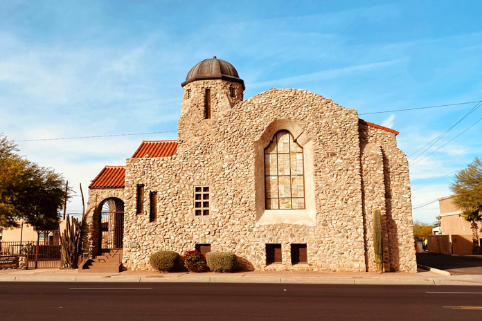
The Museum of Casa Grande is housed in a beautiful Southwestern mission-style stone building. More than 40 buildings in the city are listed on historic registers.
This southern Arizona loop is best navigated from fall to early spring, as the desert temperatures are toasty in the summer. What it lacks in curves, it makes up for with a full plate of other entertaining Cs.
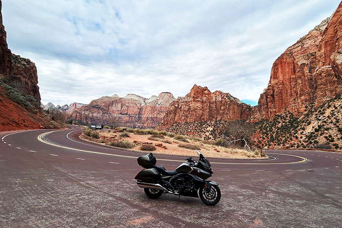
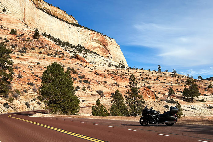
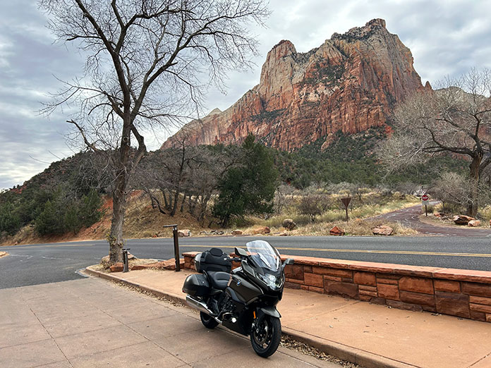
There are several hairpins just west of the 1.1‑mile Zion‑Mt. Carmel Tunnel, which separates distinctly different parts of Zion National Park in southern Utah.
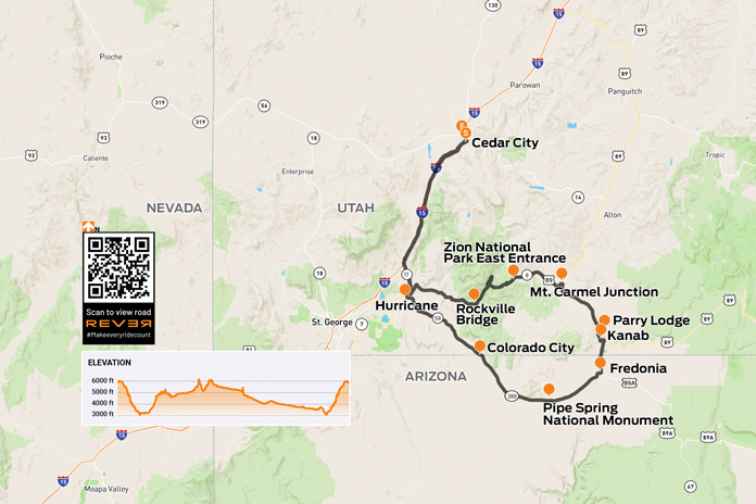
Living at 6,000 feet in Cedar City, Utah, most of my winter riding involves heading south, which offers a quick drop in elevation and less chance of the falling white stuff. So that’s what I did a week before Christmas, giving myself a gift of a one‑day ride through some southern Utah and Arizona history.
The day promised unseasonably warm temperatures…eventually. Just after the sun peeked over the mountains, the ambient temperature was in the upper 20s, but doing 80 mph on the interstate meant I was closer to single digits. Thankfully, the BMW R 1600 GTL Grand America I was riding offers great wind protection, and with my California Heat heated apparel (see California Heat gear review here), I didn’t need to use the bike’s seat or grip warmers.
Utah is one of the few states where even interstate riding offers great views. Descending the Black Ridge south of Cedar City, the mountain terrain changes from gray and sage green and reveals distant red rock mesas. Exiting Interstate 15, I took State Route 17 to Hurricane and connected with State Route 59.
After a quick climb out of Hurricane, SR‑59 flattens out and heads south. Just a few miles outside of town, jagged peaks painted in rust, deeper reds, and oranges rise in the distance. Much of this area is managed by the Bureau of Land Management, and numerous dirt roads meander from the highway.
If you keep your eyes open on the east side of Zion National Park, you’re likely to see a mountain goat…and much less tourist traffic. Plus, the curvy road is open to motorcycles all year.
Within an hour, the temperature had risen nearly 20 degrees as I rolled into the small twin cities of Hildale, Utah, and Colorado City, Arizona, an area locally known as Short Creek. Much has already been written about this area that is both the last U.S. stronghold of the FLDS church (read: polygamists) and the non‑FLDS members struggling against that stigma, so I’ll just say they have a beautiful place to live.
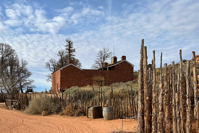
Continuing on, the road isn’t especially exciting, but the scenery remains impressive. Crossing into the Kaibab Indian Reservation, the road heads east, paralleling red cliffs to the north. To the south, on a clear day, you can see as far as 60 miles into the Arizona Strip – a wedge of that state between the north side of the Grand Canyon and the Utah border – without any signs of humanity. The desolation makes it easy to imagine life a couple centuries ago. However, not far onto the reservation is a sign for Pipe Spring National Monument, an oasis in the desert where Mormon pioneers erected a fort in 1872 for protection against some of the very people whose land they had settled on. Located a half mile off the highway, the museum and fort are worth a visit.
The fort at Pipe Spring National Monument was built as both a ranch house and protection for settlers during the Black Hawk War. It later served as a refuge for polygamist wives.
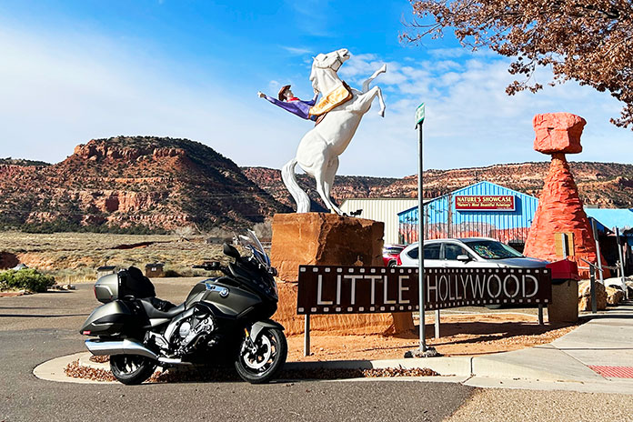
Farther east, I picked up U.S. Route 89 in Fredonia, and 7 miles later, I rode into Kanab, Utah, known as “Little Hollywood” for its filmmaking history, particularly old Westerns. My family likes to come here in February for the annual Balloons & Tunes Roundup hot air balloon festival. The historic Parry Lodge is a fun place to stay, and there’s a good mix of dining options.
Outside of town, the road cuts into the red rock, climbing and then dropping again into Mt. Carmel Junction, with the landscape colors changing from red to white to yellow.
The only thing missing from this photo taken in Kanab, Utah, (aka “Little Hollywood”) is a locomotive.
Taking State Route 9, this diversity of landscape continues with almost every twist and turn, both in tones and textures, leading to the east entrance of Zion National Park. For most of the year, you can only get up the road into Zion’s main canyon via shuttle, but as spectacular as the towering cliffs in the main canyon are, I much prefer riding on the east side, which is always open. It’s like an alien landscape, and with the slower speeds, you get to enjoy both the views and the numerous curves.
The Zion Canyon Scenic Drive is closed to personal vehicles most of the year.
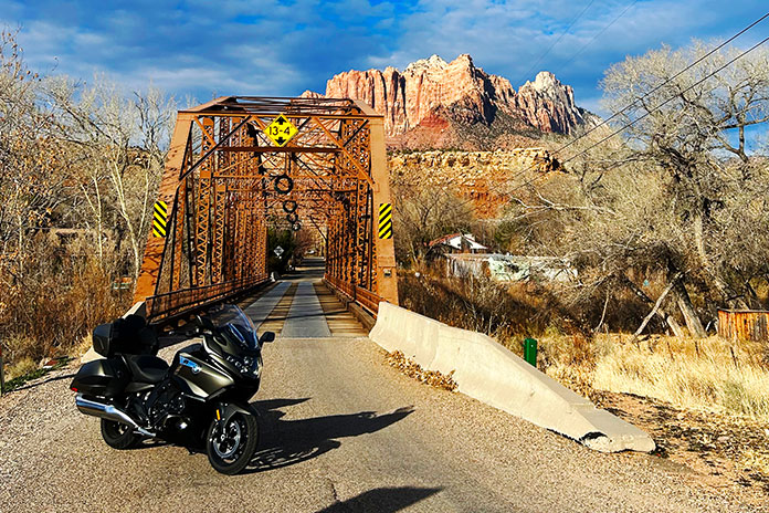
On the west side of Zion is Springdale, a typical national park gateway community with lots of lodging and dining options (depending on the season), as well as art galleries and novelty shops. Just a few miles past Springdale is Rockville, where you can detour on Bridge Road to cross over the Virgin River on the last surviving Parker‑through‑truss bridge in Utah. Continuing 3.5 miles on this road, which turns to dirt about halfway, takes you to Grafton Ghost Town, where parts of Butch Cassidy and the Sundance Kid were filmed.
The Rockville Bridge is listed on the National Register of Historic Places. Built in 1924, it enabled the first direct link from the Grand Canyon North Rim to Zion National Park.
Staying on SR‑9, it’s about 16 miles from Rockville to close the loop at SR‑17 in La Verkin, where I made my way north and back home. Like the places I’ve ridden through, this Favorite Ride is now in the history books.
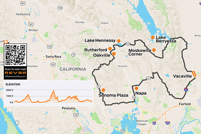
Lake Hennessy and Lake Berryessa highlight the northern arc of this spectacular loop ride through Sonoma’s hill and wine country.
This is a tale of two amazing rides. One threads its way through some of Northern California’s beautiful wine, lake, and hill country. The other winds its way through my very being to the center of my heart.
Recently, my wife and I traveled to California’s Sonoma wine country to attend a ceremony in which our son‑in‑law, Lt. Col. Joffre Lander, assumed command of a squadron at Travis Air Force Base. Since I don’t like to be far from a motorcycle when traveling, I took my BMW G 650 X‑Country along for the trip.
Sonoma’s backroads trace beautiful paths through rolling hills.
A Wine Country Loop
During a lull in the military and familial activities, I snuck the BMW out for a loop ride through the golden hills and grapevine‑lined terrain in the Sonoma region. I rolled out of Vacaville on Interstate 80 to reach the sweeping corners of narrow, scenic Wooden Valley Road, which is lined by trees and passes through rolling grasslands and vineyards.
The turn onto State Route 121 provided even more varied terrain as rock outcroppings added texture to the ride. Various wineries staked their claims with stone archways and beckoning signage. As SR-121 morphed into State Route 12 on my approach to the town of Sonoma, the density of wineries increased.
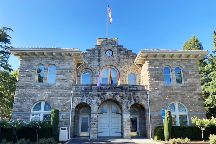
When I threw down my kickstand at Sonoma Plaza, I had no idea of the historical significance of the town of just over 10,000 souls. Across the street from the beautiful centerpiece park rests the Sonoma State Historic Park, which is a cluster of historic sites. It’s an open and easy stroll through locations like the Mission San Francisco Solano, Sonoma Barracks, Toscano Hotel & Kitchen, and other fascinating buildings.
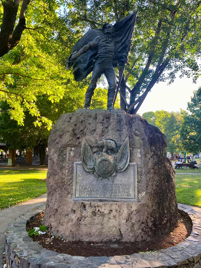
After walking back to the vibrant green shade of the 8‑acre Sonoma Plaza, I stood in the shadow of the impressive Bear Flag Monument, which commemorates the spot where the Bear Flag Party raised the Bear Flag and declared California free from Mexican rule in 1846. After a walk around Sonoma City Hall in the center of the plaza, I continued my clockwise loop ride.
The Bear Flag Monument honors a significant moment in California history.
SR‑12 led me to Trinity Road and other narrow, winding byways that are thoroughly entertaining, curvaceous rolls beneath trees, beside cliffs, and over hills, often with panoramic views.
After passing through Oakville and Rutherford, I headed farther east on State Route 128. This stretch was arguably the most beautiful part of an already spectacular ride. I rolled past Lake Hennessy, Lake Berryessa, and several family wineries. Finally, I headed south back to Vacaville and to my daughter’s home. Would this be the end of my tale? Hardly.
Sonoma City Hall is the centerpiece of Sonoma Plaza.
A First Long Ride
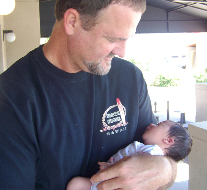
In 2011, I welcomed my first granddaughter into this world. I vividly remember the overwhelming love I felt when I held little Skya for the first time. The tiny black‑haired treasure in my arms was so perfect and so lovely that I was instantly and indelibly smitten.
Over the dozen years since she was born, I have taken Skya on many short motorcycle rides around the yard or the block with her planted securely in front of me on the saddle. She has grown from a fragile cherub to a vibrant, smart, lovely pre‑teen, and motorcycle rides have been a vital part of our deep and loving connection.
The author’s granddaughter captured his heart from the first moment he held her.
On this occasion, Skya was waiting when I rolled into my daughter’s garage. As we sat and talked, it became clear she was ready for her first longer motorcycle ride. Parental permission was secured, and I fitted Skya in my wife’s riding gear. We discussed what it takes to be a safe and secure passenger on the back of a motorcycle.
With a wave to her mother and grandmother, Skya and I headed north for a loop ride. Almost instantly, she found the groove and became a settled “sack of potatoes” on the back of the BMW. The repeated portion of my earlier route took on a new significance as I could feel the wonder Skya was experiencing. She would occasionally tap me to point things out, and as we flipped up our faceshields to talk, I could see the joy in her green eyes.
Full-face helmets can’t hide the joy on those two faces. A “favorite ride” indeed!
We stopped often to decide on routes, take in views, and just chat. At one stop, I pointed out the smooth, pale hills on the horizon. I mentioned that they reminded me of Hills Like White Elephants, a short story by Ernest Hemingway, and I recommended that she read it someday. Back on the motorcycle, Skya chose the routes, including a long road to a dead end that gave us both a laugh.
I have ridden thousands of miles in my lifetime, and the miles that Skya and I shared that day are some of the most significant. We agreed that when she gets a few more years under her belt, we will reconvene for an extended ride. We can’t wait.
The nimble BMW G 650 X-Country was the perfect mount for the curvy sections of the route.
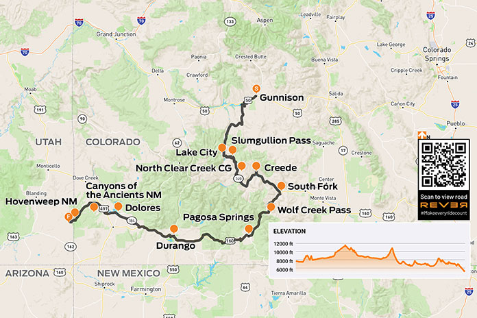
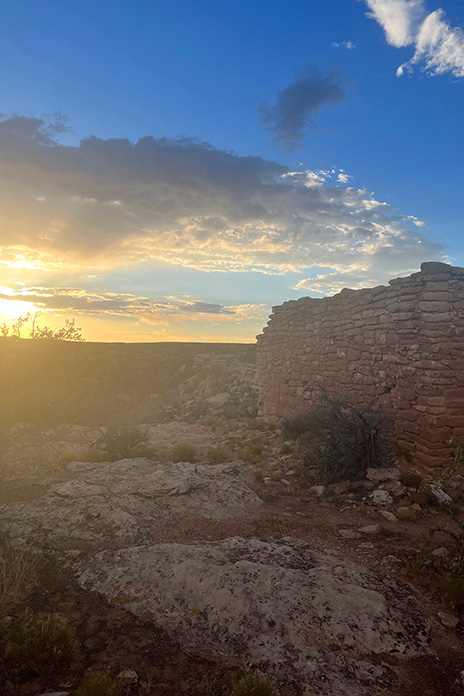
C. Jane Taylor’s moto memoir Spirit Traffic was published in 2022. That summer, she and her husband embarked on a 97‑day cross‑country book tour on their BMW F 650s. She said her book tour was characterized by deeply rewarding and completely exhausting work. It also featured great roads. During her vacation from what some might already consider a vacation, she enjoyed many memorable rides. The leg from Gunnison, Colorado, to Hovenweep National Monument in Utah was a favorite. –Ed.
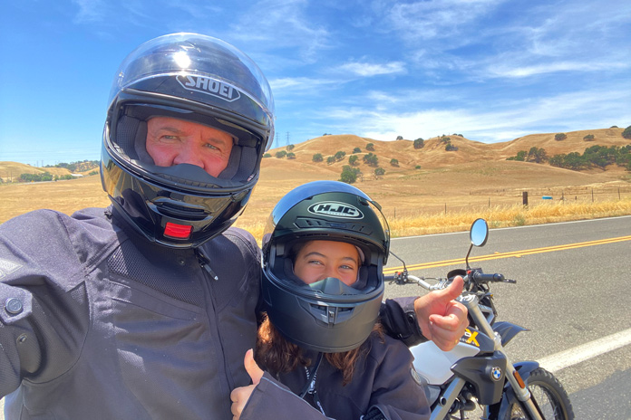
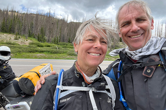
My husband, John, and I rode for 97 days – from Maine to California and back to Vermont – on a national book tour in the summer of 2022. We snapped this selfie at 10,856-foot Wolf Creek Pass in Colorado.
West of Gunnison, Colorodo, U.S. Route 50 was closed. We’d seen signs about the closure for at least 100 miles. Those signs were for other people, right? We’d planned to stay on the famous Colorado byway through the Grand Mesa, Uncompahgre and Gunnison National Forests as long as we could. But as we approached Gunnison, our shoulders slumped with the reality that the signs were for us. We’d have to rethink our whole route. And the weather was starting to look iffy.
At the Gunnison County Chamber of Commerce, a note taped to the door underscored the closure. We went inside, paper roadmap in hand. At the desk, the clerk proffered her own map, opening it in front of us. She and John pored over it like kids seeking clues to lost treasure.
She confirmed that U.S. 50 was closed and suggested State Route 149 instead. It had less traffic and was more beautiful, she assured us. We compared her map to the Butler map for the region. (Butler Motorcycle Maps highlight the best roads, rating them on twisties, traffic, road surface, etc.) SR‑149 was G1 (gold), Butler’s highest rating – perfect!
After filling our water bottles, we headed to the gas station. SR‑149 is quite rural, so we wanted to be prepared. As John filled our tanks and I surveyed the darkening skies, a bolt of lightning ripped through the clouds. Thunder crackled. A guy next to us gassing up his pickup was watching too.
“Hope you’re not going that way,” he said, nodding toward the storm.
“Not anymore,” I said.
We paid for our gas as the storm clouds gathered closer and closer. Thunder rumbled, and lightning struck from cloud to ground in the near distance. We sped back to the park next to the Chamber and ran for the cover of a gazebo. Just as we stepped under, buckets of rain dumped from the sky, and lightning dashed all around us. The thunder was so loud that we ducked our heads each time it clapped.
John snaps another selfie on SR-149 along the Lake Fork River. As two cross-country-and-back trips have taught us, body temperature management in variable conditions demands a good rainsuit – and a good attitude.
Celebrating our excellent timing, we stretched out to nap on top of the picnic tables just as two vans arrived and disgorged two dozen kids. It was the local mountain‑biking camp escaping the weather. We were instantly surrounded by kids eating popsicles and playing a raucous game of tag. Now each thunderclap was accompanied by the ear‑piercing screams of prepubescent mountain bikers. One of the camp counselors checked in on our welfare, asked about the bikes, and offered popsicles, which we accepted.
The lightning eventually abated, though the rain drizzled on. The camp counselors packed their charges and drove away. We wrestled into rainsuits and got back on the road.
SR‑149 was as wonderful as described: a narrow, almost abandoned two‑lane road snaking seductively through the San Juan Mountains and the Rio Grande National Forest. The weather was cold and drizzling, but the road was curvy, and the air smelled like earth and springtime in New England. We were in motorcycle heaven.
Ten miles down the road, oncoming cars flashed their headlights, gesturing to slow down. Thinking they were trying to warn us about a cop, I laughed. It had taken me five years to get up to the speed limit. We continued with caution until a mudslide stopped us in our tracks. If we hadn’t been wearing helmets, we would have scratched our heads in a “Now what?” gesture. Like U.S. 50, it seemed SR‑149 would soon be closed too, but we gingerly traversed the shallow edge of the slide at the far‑left side of the road. Alert to the changes in road surface and rambunctious streams in the gullies flanking the road, we pushed forward like children anticipating candy at Halloween.
SR-149 near Powderhorn, Colorado.
Instead of candy, we sought groceries as we rolled into Lake City and its tiny country store whose proprietors seemed to be a badly mismatched couple. The woman in long braids glared at us as if we’d tracked mud onto her freshly mopped floor, while the man – handsome in a Willie Nelson kind of way, if Willie Nelson could be considered handsome – happily greeted us, teasing about our florescent green rainsuits. “We are not men, we are Devo,” he joked in a robotic voice referencing the ’70s New Wave band famous for their quirky spaceman costumes. We bought vegetables, tortillas, and cheese for quesadillas we would cook once we found a campsite for the night.
Lake City is an eye‑blink of an old mining town with the down‑at‑heel aspect of a climate-change ski resort in shoulder season. The cold, damp weather did not bring any charm to the Grizzly Adams cabins lining the road.
I attributed the town’s creepiness to its horror‑movie sepia tones and bad weather, but I later learned that Lake City gained notoriety in 1875 when Alferd Packer, the “Colorado Cannibal,” was charged with killing and eating the prospectors he’d been hired to guide through the San Juan Mountains after the group had become snowbound. In the spring, five bodies with human teeth marks were found at the foot of Slumgullion Pass. Lake City’s Hinsdale County Museum has an extensive collection of Packer memorabilia, including a skull fragment from one of his victims and several buttons from the clothes of the five men he ate. The area where the bodies were discovered is now known as Cannibal Plateau. Odder still, the area hosts an annual Alferd Packer Jeep Tour and Barbecue.
As we approached the peak of Slumgullion Pass near Lake City, Colorado, the rain abated, and the skies cleared.
My unease was supplanted by the fear and exhilaration of climbing out of town along steep, wet switchbacks to Windy Point Observation Site and Slumgullion Pass. As we climbed, I chimed into the headset, “Don’t look right, Johnny.” The narrow two‑lane highway had no guardrail, and the drop-off induced a vertigo that made me tighten my grip on my handlebar and tank. At Windy Point, we stopped to look back at the long narrow valley thousands of feet below us.
Evening was approaching, and we were still in the middle of a sheer climb on our way to North Clear Creek Campground, a destination we were not sure even existed, but the sky finally opened, and the tight switchbacks loosened as we topped 11,530‑foot Slumgullion Pass.
The map we consulted – and re‑consulted – showed the campground within 50 miles. Trying to keep from being swept up in the National Geographic beauty of the broadening landscape, I kept my eyes peeled for a Forest Service campground sign. We were hungry and cold, and it was getting late. We’d passed so little traffic, I was game to pitch the tent at the side of the road, but John persisted.
North Clear Creek Campground in Colorado’s Rio Grande National Forest was our home for the night after an eventful ride.
We finally turned off SR‑149 and crossed a cattle guard onto Forest Road 510, which fell away to vertiginous Class‑IV switchbacks. I groaned but also laughed. It was the “dropping hour.” We have a joke that on extended motorcycle trips, we often face the most challenging miles of the day right before arriving at our destination exhausted and hungry. The road toyed with us. I inched down its sharp gravel turns, determined but cautious given the hour. As I eased down one hill, a young woman on a dirtbike blasted up it. Encouraged that there might be an actual campground ahead and inspired by another woman on a bike, I sped all the way up to 2nd gear!
Pink sunglasses reflect the expansive valley near Creede.
After almost missing the 70‑degree turn into the campground at the bottom of the hill and duck‑walking the bikes back over sandy gravel ruts, we casually rolled into the nearly vacant campground and found a suitable spot with a picnic table, breathtaking panoramic views, and a glorious sunset reflected off the peaks of the Rio Grande National Forest.
The next morning was cold and clear. With visions of coffee and pastries dancing in our helmets, we headed toward Creede, home to an underground mining museum, the Mineral County Landfill, a cemetery, a chapel, and an excellent little food truck/coffee shop that appeared to be set up during the pandemic like a one‑way street, with one entrance and one exit. The pastry case was filled with buttery French confections, the air with the scent of espresso. Bon appétit! We took our pastries to a table outside where we lounged, sipping cappuccinos in the sun.
The population of Creede, Colorado, swells from 300 to 10,000 on July 4th. After a cold, wet, challenging ride the day before, it was an oasis. We found a mobile coffee shop where we enjoyed the company of locals, pain au chocolat, and cappuccinos in the sun.
The road along the Rio Grande – which far downstream serves as the border between Texas and Mexico – was as good as the croissants. At South Fork, we headed south on U.S. Route 160 and climbed to 10,856‑foot Wolf Creek Pass. It was cold at elevation, and we encountered traffic and threatening weather, but the road was smooth, wide, and curvy through Pagosa Springs and Chimney Rock. We lunched in Durango after a torrential downpour trapped us under a busy highway underpass.
U.S. 160 through the mountains near Hesperus Ski Area was fabulous despite the cold and wet. Things got warmer as we descended out of the mountains, and by the time we got to Mancos, we were sweltering in the heat of the desert. We took off as much as we could and poured cold water down the backs of our armored jackets. Body temperature management was a challenge we had improved at over time.
South of Creede, the Rio Grande snakes along SR-149 on the way to South Fork.
In the blazing heat, we headed west on State Route 184 toward Dolores, then north on U.S. Route 491 past Yellow Jacket and into Canyons of the Ancients National Monument, administered by the Bureau of Land Management and inhabited almost solely by spirits. The road narrowed and then narrowed again. There is something gritty and fundamental about these small roads, something secret and unspoken like the second indents of an outline of one’s life or the dark side of the moon.
The heat kept building. As we crossed into Utah, the landscape gave way to a barren, flat emptiness without trees or buildings. We traveled in silent awe, feeling exposed in the heat but excited about the ruins of Hovenweep National Monument.
Our day took us from cold rain and high passes to sweltering heat and desert valleys. The sunset at Hovenweep was a just reward.
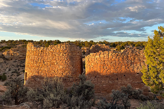
Known for six groups of Ancestral Puebloan villages, Hovenweep contains evidence of occupation by hunter‑gatherers from 8,000 B.C. until AD 200. We were finally going to visit the spirits we’d been sensing on this hot road.
We turned into what seemed the middle of nowhere, but John assured me this was the way. I saw only shrubs, grasses, and sage until I glimpsed a sign the size of a sheet of paper with an arrow proving him right: Hovenweep National Monument. We traversed a lunar landscape of sand, craters, dead volcanoes, and lava flows until we happened upon a herd of wild horses in the middle of the road. We stopped to gape. Shy and beautiful, they paused in their grazing to examine us. Though I wanted to join these beasts on a romanticized journey out of a dream, we had to keep moving. Standing still in the late afternoon heat was a torture neither of us wanted to endure – magical, wild horses notwithstanding.
Sunset on the ruins at Hovenweep National Monument in Utah.
Reminiscent of Death Valley with its lethal sun, long straightaways, and distant bluffs, Hovenweep Road also reminded me of the song by America “A Horse with No Name.” I started to understand the line “In the desert, you can’t remember your name.” In the heat and arid sameness of the landscape, time seemed to stop. I could tell we were moving, if only for the visual cue of the scenery receding in my mirror. I became flooded with the eerie sensation of being watched. It felt as if the ghosts of millennia were hovering just above the heat waves upwelling from the macadam.
“Hovenweep” is a Paiute/Ute word meaning “deserted valley.” As we rode into the scorched campground, I sensed that the ancestors were still there. A clan of attentive ravens seemed to be protectors – or just eager to see what food they could liberate from us.
Hovenweep is a special place, and we had the distinct feeling that the ancestors were still there.
After pouring rationed water onto our heads and down our backs, we hiked off to see the ruins, following a faint path between rock walls leading to a dry creek bed. Walking fast to beat the setting sun, we climbed down into the creek bed then up the other side until we saw what looked like a crumbling brick silo. Hovenweep at last! As we gazed in silence at the majestic ruins of a once‑lively community, a rainbow broke through distant storm clouds. Back at our campsite, we cooked dinner in the waning light as a million stars began to wink.
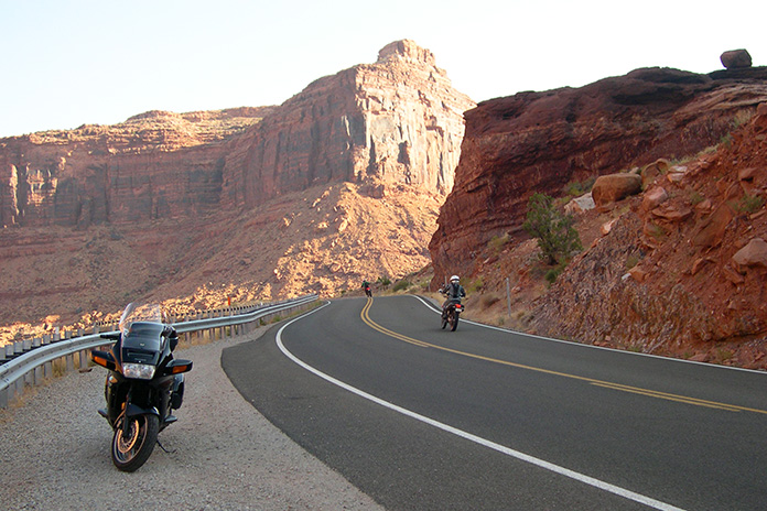
Utah State Route 128 is a scenic byway on the way to Moab, Utah, that winds through a canyon carved by the Colorado River.
Moab, Utah, is an ideal destination for a motorcycle trip. Where else can you find sandstone arches, red‑walled canyons, snow‑capped mountains, scenic byways, two national parks, and a fun, adventure‑ready town? The best time to visit is in the spring or fall because it’s often too hot in the summer and roads can get icy in the winter.
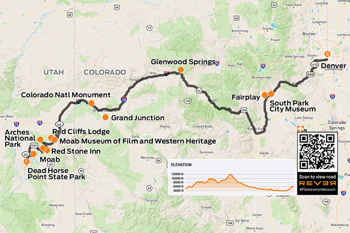
Since I live in Denver, on the other side of the Rockies, part of the fun of visiting Moab is simply getting there. Heading west out of the city, U.S. Route 285 climbs the Front Range before passing through mountain towns like Conifer (8,277 feet), Bailey (7,740 feet), and Fairplay (9,954 feet).
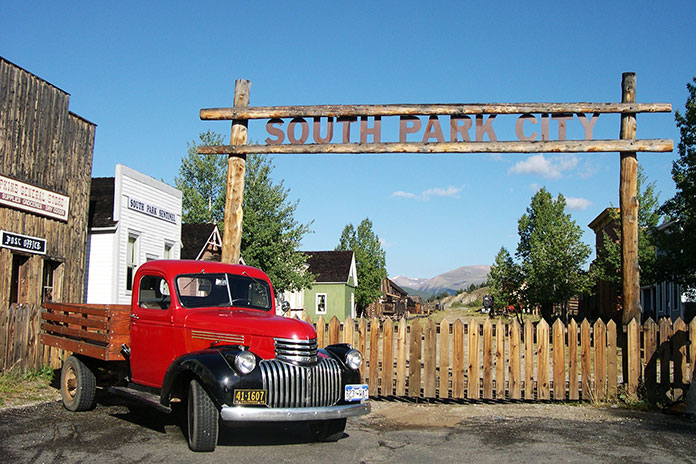
Riding through the Rockies means going over mountain passes, and on the way to Fairplay, you’ll cruise over Kenosha Pass (9,997 feet) and Red Hill Pass (9,993 feet) before descending into a broad valley. Such grand vistas across open range show the true beauty of Colorado. Fairplay is an old mining town named after the notion that all miners should have an equal chance to stake a claim. It’s home to South Park City, an open‑air museum preserving a 19th century mining town, including over 40 original buildings and thousands of artifacts from the boomtown days.
South Park City in Fairplay, Colorado, is an open‑air museum that preserves a 19th century mining town.
Continuing south on U.S. 285, the road becomes U.S. Route 24 at Antero Junction and goes south and then north through Buena Vista (7,925 feet) and Granite (9,012 feet). At Twin Lakes, turning west on State Route 82 takes you across the Continental Divide at Independence Pass (12,095 feet), where the air is thin and always chilly.
The author and his Yamaha V Star 1300 Tourer at the high point of his ride from Denver to Moab.
The long, winding descent to the ski town of Aspen is pure pleasure. SR‑82 ends at Glenwood Springs, and the next 134 westward miles follow a curving section of Interstate 70. If you have the time, I recommend the scenic Rim Rock Drive through the Colorado National Monument among the high cliffs above Grand Junction.
After crossing into Utah, take the first Moab exit for State Route 128, which is a scenic byway that winds through a majestic red rock canyon carved by the Colorado River. Highlights include the stunning Fisher Tower and Castle Rock, a finger‑like spiral to the southwest that’s been seen in many films and commercials.
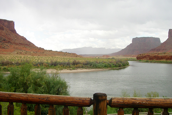
At milepost 14 on SR‑128 is the Red Cliffs Lodge, built on the old George White Ranch, another location used in many Western films. If you’re a cowboy fan like me, visit the lodge’s Moab Museum of Film and Western Heritage to see production stills, movie posters, autographed scripts, props from movies filmed nearby, and displays about Western heritage. Lunch or dinner at The Cowboy Grill is highly recommended.
View of the Colorado River from the deck at Red Cliffs Lodge, which has dining, lodging, and a museum dedicated to Western films and heritage.
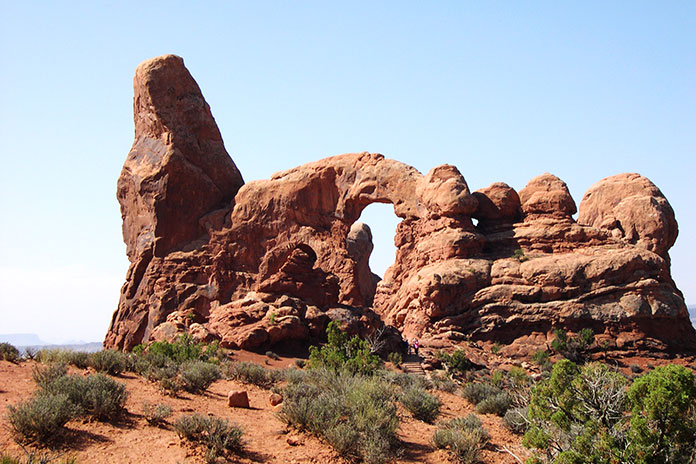
The key attractions in Moab are Arches and Canyonlands national parks. Arches, located just a few miles north of town, is the more popular of the two, and the nearly 20‑mile paved road through the park takes you past a stunning array of sandstone arches, petrified dunes, and red rock formations.
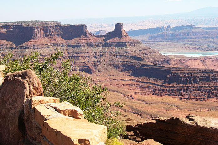
Canyonlands is the largest national park in Utah, and its diversity staggers the imagination. The park is 32 miles from Moab and has 20 miles of paved roads with many pullouts offering spectacular views. The Island in the Sky sits atop a massive 1,500‑foot‑high mesa, and on a clear day you can see over 100 miles in any direction. Sunrise and sunset are particularly beautiful times of day to enjoy these panoramic views of canyon country.
Arches National Park is a wonderland of sandstone arches, pinnacles, and other rock formations. The park gets busy, so it pays to go early.
Scenic State Route 313 leads to both Canyonlands and Dead Horse Point State Park, which offers unforgettable views of deep canyons and cliffs overlooking the Colorado River. I recommend taking time to explore side trails to see different viewpoints in this one‑of‑a‑kind area.
The La Sal Mountain Loop, a 36‑mile scenic road that starts at SR‑128 near Red Cliffs Lodge and goes through Castle Valley, up into the La Sal Mountains, and then back down to Moab near Spanish Valley, is another great local ride.
One of the many awe-inspiring vistas at Dead Horse Point State Park.
Moab is an ideal base camp for lodging, dining, and other adventures such as whitewater rafting, hiking, mountain biking, and off‑road riding and driving (you can rent Jeeps, ATVs, and side‑by‑sides). One of my favorite places to stay is the Red Stone Inn, a rustic but clean and affordable motel with a communal hot tub and picnic area and rooms with a TV, free wi‑fi, and a mini kitchen.
Whether you travel across the Colorado Rockies, through the red‑rock canyons of southern Utah, or take some other route to get there, put Moab on your “must visit” list. I promise you won’t be disappointed.
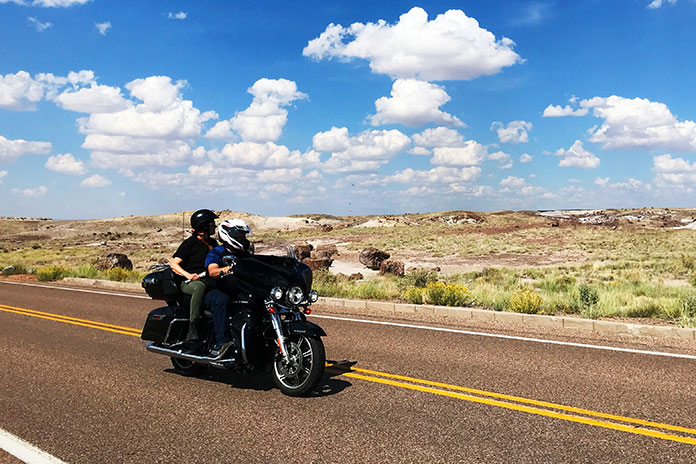
Fellow riders take in the otherworldly landscape of Arizona’s Petrified Forest National Park along the author’s Flagstaff to Albuquerque motorcycle ride.
If you blindly follow your GPS, a Flagstaff to Albuquerque motorcycle ride is a 320‑mile drone on Interstate 40. That’s fine if Point A to Point B is your only plan. However, most motorcyclists are suckers for interesting byways and intriguing places, and I am no exception.
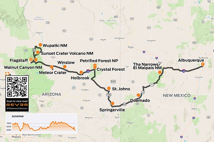
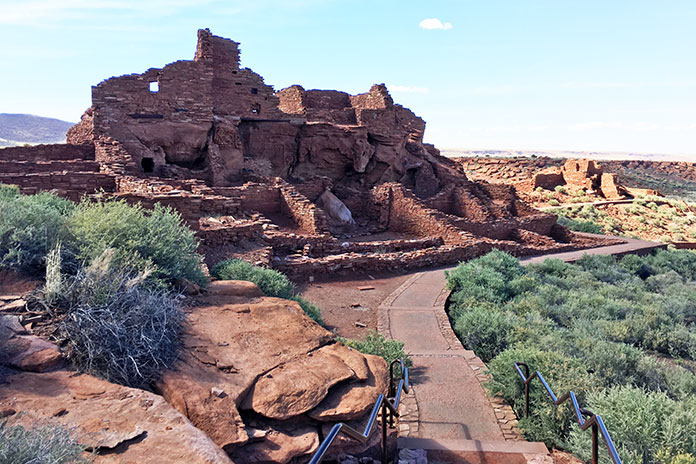
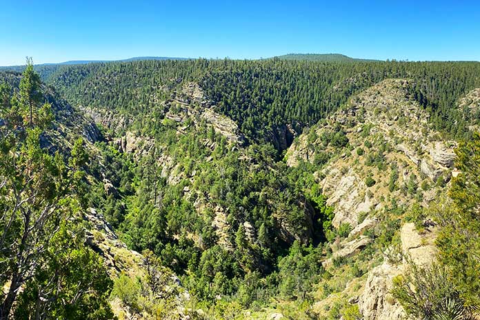
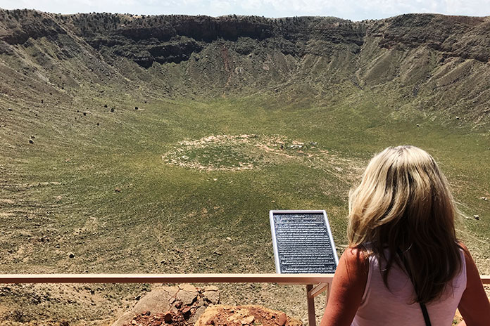
Embracing that character trait, I planned a convoluted ride that would add about 180 miles and several hours to this trip. I was not just adding saddle time; I was also adding several historically and culturally significant landmarks. Instead of simply slaloming through long‑haul trucks on the freeway, I would make a loop through three national monuments near Flagstaff: Wupatki, Sunset Crater Volcano, and Walnut Canyon. Continuing east, I’d visit Meteor Crater, Standin’ on the Corner Park, Petrified Forest National Park, and in New Mexico, El Malpais National Monument.
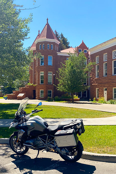
Before that roundabout route, I needed to spend some time in my all‑time favorite small city, Flagstaff. I lived some of my most memorable years in these mountains. I am a graduate of Northern Arizona University in Flagstaff, and any time I’m in the sky‑high city is a personal joy.
As I rolled through the campus for some serious reminiscing, many of the buildings brought back indelible memories. There is one location that is uniquely special. I spent my sophomore year in the school’s stately Old Main building when it was still a dormitory. Decades before I was a gleam in anyone’s eye, my parents took a photo on its iconic steps. The historic red Moenkopi sandstone building was constructed in the late 1800s and is the centerpiece of both the beautiful campus and my love for Flagstaff.
The author stops to reminisce at Northern Arizona University’s Old Main building in Flagstaff.
After leaving the campus, I rode through Flagstaff’s charming downtown area. Iconic hotels in the area like the Hotel Monte Vista and the Weatherford cast a historic shade over the lively, rejuvenated entertainment and shopping district.
Downtown Flagstaff, Arizona.
There is no shortage of things to do downtown, including the Orpheum Theater, many dining options, and unique specialty shops. The area is much more polished and refined than when I was in college.
Flagstaff’s revitalized downtown area, which sits at nearly 7,000 feet on the Colorado Plateau, is a hotbed of activity in both the cool summer months and when blanketed in snow.
As an undergraduate, I spent a fair amount of time “studying” in various Flagstaff watering holes, like the venerable Museum Club. This time around, as I dropped the kickstand in front of the log‑built establishment dating back to 1931, visions of live bands and lukewarm beer flooded my memories. Some of Flagstaff’s history was lost on me while matriculating, but the slightly more mature “me” appreciates the vintage, mountain‑chic nature of the city that lies on historic Route 66.
The historic Museum Club has been a fixture in the mountain city since the Great Depression era, and it was one of the author’s favorite haunts during his college days.
After leaving Flagstaff, I headed north on U.S. Route 89 toward the scenic loop through the first two national monuments slated for my ride. This first little spur of my wandering route to Albuquerque was more of a flyby, as I have visited both Wupatki and Sunset Crater Volcano in the past.
Near the northernmost point of what is fittingly called the Sunset Crater‑Wupatki Loop Road is a significant archeological site. In the early 1100s, Pueblo communities built Wupatki, a bustling center of trade and culture. The site is well worth a walkabout. After looping farther through the otherworldly landscape of this part of northern Arizona, I came to Sunset Crater Volcano. You can see virtually the entirety of the park from the saddle along the loop road. Peering directly into the mouth of the cinder cone is no longer permitted due to foot traffic erosion; however, a long view of the nationally protected volcanic field is still a wonder to experience.
Sunset Crater Volcano, formed during an eruption in 1085, rises more than 1,000 feet above the surrounding landscape and is visible from most of the scenic loop road.
After completing the loop road, I headed east on I‑40 for a skinny minute to the access road for a national monument I had not visited previously. Walnut Canyon is just a short jog off the interstate through pines, oaks, and junipers. The endgame is a visually stunning canyon environment rich in rugged natural beauty and early human history. I did not walk the park’s Island Trail, a strenuous one‑hour hike past the early cliff dwellings; however, I took in the big‑picture experience of the park’s rim trail, which offers great views of the dwellings and the rugged topography.
Wupatki National Monument sits as a visually stunning reminder of past civilizations.
At this point in my Flagstaff to Albuquerque motorcycle ride, I had been in the saddle or exploring for well over an hour, and I was only 8 miles outside of my original launching point. I did say I was not taking the most direct route to Albuquerque! My eastward trek resumed on I‑40 and was exactly what freeway travel is designed to be: fast, efficient, and boring. My speedometer needle was pinned resolutely at 75 mph as I rolled through the tall pines of northern Arizona, which melted into junipers and then grasslands as I made my way toward the next attraction.
Walnut Canyon, a short hop off Interstate 40, is easily accessible even in motorcycle boots.
About 40 miles out of Flagstaff, I came to the exit ramp for Meteor Crater. There are numerous “teaser” signs along the access route that are intended to build anticipation for the natural wonder at the road’s terminus. As I approached, I saw the ultimate teaser: an enormous raised, round “lip” that is evidence of the cosmic collision that occurred thousands of years ago.
I rolled into the parking lot and secured my pass to see the crater. On my way to the viewing areas, I enjoyed a series of museums and displays that cover the history of space travel, hypothetical (corny?) representations of aliens, and the scientific nature of the meteor that found its way to earth some 50,000 years prior to my visit.
The author’s wife takes in the view at Meteor Crater, which is located between Flagstaff and Winslow, Arizona. The site offers several fascinating observational perspectives.
As I finally made my way outside the facility to the viewpoints along the rim of the crater, the massive bowl did not disappoint. One cannot help but stand in awe of the impact that created the earthen wound. There are several vantage points from which to view the crater, as well as preset telescopes for a closer look at its interesting features. Well worth the visit.
With the cosmic pockmark fading in the rear views, I was back on the interstate for a quick jaunt. Most of this ride was a survey in ancient places, but there was a little musical interlude singing its siren song in downtown Winslow. I pulled up to the intersection of Route 66 and North Kinsley Avenue, now designated as Standin’ on the Corner Park, where a flatbed Ford was conspicuously parked.
Sure, it’s kitschy, but for anyone who has crooned along with the 1972 Eagles song “Take It Easy,” it’s a must stop. I took the requisite photo with a bronze Glenn Frey and searched in vain for the girl in that flatbed Ford. Winslow is also home to the historic La Posada Hotel, the Old Trails Museum, and Homolovi State Park.
No Route 66 ride would be complete without stopping at the “corner” in Winslow, Arizona.
Again heading east, the next town of note into which I rolled was another Route 66 remnant. Just off Holbrook’s main drag rests an iconic mid‑century attraction. Over a dozen large, conical teepees make up the historic Wigwam Motel. Those structures and the classic cars staged around the property beg for a visit and photos.
The Wigwam Motel, a Route 66 fixture in Holbrook, Arizona, is worth a stop for a dose of 1950s Americana.
Just 30 miles east of Holbrook is the exit for Petrified Forest National Park. I rode due south on what would be an extended departure from any interstate highway. After paying my entry fee, I rolled into a lunar‑esque landscape rich in pastel hues and forever views. The road through the heart of the park is 26 miles of intrigue.
I stopped at Newspaper Rock, which features hundreds of ancient petroglyphs of animals, weapons, and humans. The etched figurines tell a fascinating story, including how the exaggerated endowment on the male stick figures speaks to the fact that men never change.
The author pulled off his riding gear for a walk through the Petrified Forest, which preserves fossilized logs from trees that lived 225 million years ago.
At my next stop, the park’s Crystal Forest, I pulled off my gear for a walk among the massive petrified logs that lay strewn throughout the undulations of the walking path. The path is a sojourn into a prehistoric wonderland. Logs lay as massive, independent rounds as well as segmented pieces where they fell millions of years ago.
Entry into New Mexico brings with it a unique Southwestern feel.
Geared up again, I exited the park to the south and continued on the longest side leg of this elongated ride to Albuquerque. I rode through the remote eastern Arizona towns of St. Johns and Springerville before heading due east on U.S. Route 60 into New Mexico. The grasslands and high chaparral landscape are wide‑open and beautiful, making for a fun Southwestern riding experience.
At the small New Mexican town of Quemado, I stopped for a quick look at the tiny Catholic mission on the outskirts of the hamlet, one of many such historic missions in New Mexico, before heading north on State Route 36. The high‑desert riding continued on State Route 117 until I came to the last of my planned stops.
Historic missions and other religious landmarks dot New Mexico’s beautiful landscape.
The Narrows is a striking rock rim feature within the El Malpais National Monument. The road follows that sheer rim for a nice stretch before the ledge eases and separates from the tarmac. The next notable feature is a picturesque natural rock bridge to the north of The Narrows. A short walk reveals the grandeur of the La Ventana Natural Arch. After a visit, my route rejoined the freeway for the final stretch to Albuquerque.
The Narrows in El Malpais National Monument is a hidden treasure in western New Mexico.
Nope, this was certainly not the quickest Flagstaff to Albuquerque motorcycle ride, but it was infinitely more memorable.
Bringing you the Best Motorcycle News from Around the Web!
We use cookies to ensure that we give you the best experience on our website. If you continue to use this site we will assume that you are happy with it.Ok