The Big Bend BDR-X 600-mile loop premiers in a live YouTube broadcast on Oct. 26.
The latest off-road route by the nonprofit Backcountry Discovery Routes will be unveiled Oct. 26 in a special YouTube broadcast. The Big Bend BDR-X in west Texas will become the 19th BDR route and the fifth BDR-X, which are shorter, loop-style routes.
The broadcast will feature a 40-minute documentary film screening and the release of GPS tracks, a waterproof route map, and route resources. Also included will be exclusive behind-the-scenes looks at the route’s development and its first expedition. It’ll be hosted from the TouraTexas Rally, and members of the expedition film team will join the broadcast.
The Big Bend BDR-X is 600 miles in length and travels through the rugged terrain of Big Bend national Park, Big Bend Ranch State Park, and surrounding areas. Enjoy desert landscapes, natural beauty, hidden-gem historical sites, and an optional foot crossing into Mexico at the Rio Grande.
“We’re excited to bring this route to life in West Texas,” says Michael Bielecki, BDR routes manager and route co-architect. “Big Bend is one of the most remote and iconic regions in the U.S. The blend of the expansive Chihuahuan Desert, the lush banks of the Rio Grande, and the majesty of the Chisos Mountains offers a perfect backdrop for riders seeking a real desert adventure.”
The Big Bend BDR-X will be open immediately after the release, and all information about the route will be available on the BDR website.
We got the chance to sit down with members of Backcountry Discover Routes for a chat about the organization and the 940-mile Northern California route for Episode 70 of the Rider Magazine Insider Podcast. Listen to the episode to learn more, and check out our other podcast episodes for more conversations with important and inspiring people within the world of motorcycling.
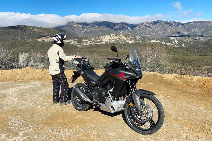
Early morning clouds hug Pine Mountain Ridge, which provides a scenic backdrop along the best part of SR-33. (Photos by the author.)
The charming and eclectic coastal city of Ventura is the launch and landing pad for this diverse 340-mile loop that crosses parts of four California counties along the Central Coast. For this California motorcycle ride, Get an early start with a breakfast burrito at one of the auténtico taquerias on Ventura Avenue, then check out the scenic views of the city, curving shoreline, and distant Channel Islands from Grant Park high above. From here we head north on State Route 33 (Ojai Freeway) toward some of the finest mountain, canyon, rural, and coastal riding in the state.
A little waterfall spills from the cliff onto this gentle curve on State Route 33 in Wheeler Gorge. It’s just north of two tunnels in the background that were blasted through the solid rock in 1931.
The 2024 Honda XL750 Transalp I chose for this ride has ample suspension travel, and its dirt-worthy 21-inch front and 18-inch rear spoked, tube-type wheels were shod with aggressive (and noisy) Metzeler Karoo Street tires. Out of the box, the Transalp can tackle many levels of dirt, but California had just experienced yet another atmospheric river of rain, so I kept the tires on the tarmac during this trip.
Ventura County | California Motorcycle Ride
In Ojai, a left turn onto Maricopa Highway keeps you on SR-33 past the last gas station (and bathroom, burrito lovers!) for 50 miles, and quite soon it traces the curves of the Ventura River and north fork of Matilija Creek past gated ranches and orchards. After crossing over the creek at the rock quarry, the road climbs and tightens up, and within a few minutes I was flinging the Transalp around some of California’s best curves.
Though nicknamed the “Half-rica” Twin, the Transalp offers more than 75% of the power and torque of its big brother, a weight savings of more than 50 lb, and a lower center of gravity. With a light load and solo rider, it’s surprisingly quick and rips smoothly through its 6-speed transmission with an up/down quickshifter. There’s enough power on tap to make quick work of hills and passes, with a deep velvety noise from the exhaust and just enough pulse feel from the 755cc parallel-Twin’s counterbalanced 270-degree crankshaft.
Four preset ride modes plus a customizable User mode deliver full power at varying rates and alter engine braking, traction control, and ABS accordingly. My 2018 CRF1000L Africa Twin labors at times riding two-up with a full load, so I wouldn’t choose the smaller Transalp for that, but a solo rider will rarely wish for more power.
From Ojai, SR-33 ascends the sunny side of Pine Mountain to its 5,160-foot summit pass, rounding dozens of exciting bends, threading passes and canyons, and skirting towering peaks on either side before winding down the mountain’s piney backside into Cuyama Valley.
SR-33 cuts through part of Pine Mountain in the foreground before twisting down to the rugged Cuyama Badlands.
On this day, the summit was enveloped in fog and mist, and slowing the pace for the wet road, I appreciated the Honda’s comfort, with an upright seating position and a plush saddle. Legroom is plentiful, vibration from the engine is almost nil, and the fairing and windscreen keep most of the cold blast off your lower body and chest. Optional heated grips get quite hot and greatly enhance the Transalp’s adventure-touring competency.
Although we’re still at 2,900 feet, once down in the wide Cuyama Valley, SR-33 straightens as if pulled taut, passing bucolic farms, horse ranches, and the community of Ventucopa. In the summer, the mountain behind us and the Pacific coast ahead can be the only respites from scorching heat on most of this ride. On this chilly winter day, though, I was happy to be in the lower, warmer valley.
Santa Barbara and San Luis Obispo Counties, Stage 1 | California Motorcycle Ride
Just before reaching State Route 166, SR-33 nips off the extreme northeast and southeast corners of Santa Barbara and San Luis Obispo counties, which are so large that we’re nowhere near their namesake cities on the coast. A reliable pitstop on this stretch is the Santa Barbara Pistachio Company, which has bathrooms, snacks, and gas. The company’s organic pistachios that it grows, roasts, and sells here on its 420-acre farm are delicious, so I always bring home a couple of bags.
Santa Barbara Pistachio Company, on SR-33 in Ventucopa, has gas, bathrooms, and delicious roasted nuts.
At the T-intersection with SR-166, you can significantly shorten the loop and still enjoy a great ride by turning left toward the town of Cuyama, and New Cuyama five miles farther on, which has gas, a market, and the Burger Barn and Cuyama Buckhorn restaurants, popular landmarks in this historic town.
This former filling station and its sunbaked relics are just west of Cuyama on State Route 166.
When oil was discovered in this valley of homesteads and ranches in the late 1940s, Richfield Oil built the town of New Cuyama to house its workforce. When the oil boom played out, the ranches and farms returned, blanketing the river valley floor with gold and green where Chumash Indians once harvested “Kuyam,” or freshwater clams.
After New Cuyama, SR-166 west is a beautiful but well-patrolled and mostly straight shot to Highway 101 at Santa Maria, cutting off the entire top half of the full route and shortening the ride to 215 miles. Pick up the latter part of the full loop by turning left on Tepusquet Road.
History buffs will appreciate passing near two oilfields (Elk Hills and Buena Vista) south of Taft on SR-33 that were involved in the 1922 Teapot Dome Scandal.
Kern County | California Motorcycle Ride
Continuing east on SR-33/166 to complete the full loop, the road winds down more than 2,000 feet into Kern County and the hardscrabble town of Maricopa. This is the Tulare Basin of California’s vast Central Valley, aka the “toolies.” Between Maricopa and McKittrick where we catch State Route 58, there isn’t much to excite the eyeballs except sandy hills and oilwells.
Mostly unpaved Soda Lake Road provides a more scenic alternative to the oilfields on SR-33 around Taft by cutting through the Carrizo Plain National Monument.
If it hasn’t rained lately and you like unpaved roads, consider turning left onto Soda Lake Road, which crosses the Carrizo Plain National Monument into California Valley, a remnant of the Central Valley 300 years ago when it was mostly grassland and deer and antelope roamed among the wildflowers. Visibly traversed by the San Andreas Fault and rimmed by low mountains, the plain after a wet winter can be carpeted with a super bloom, which looks like a scene from the Wizard of Oz. Soda Lake Road beats the heck out of SR-33’s oilfields when it’s dry but is best avoided when wet and muddy.
San Luis Obispo County, Stage 2 | California Motorcycle Ride
Soda Lake Road eventually rejoins our paved loop at SR-58, though you shouldn’t miss the section of 58 to the east that you bypassed by taking Soda Lake Road. From the left turn at McKittrick from SR-33, SR-58’s first 18 miles serve up a variety of fast straights and tight turns that rise and fall on a whim – after riding it regularly for 40 years, I still haven’t memorized them all.
A highlight of this loop is State Route 58 between McKittrick and Wilson Corner, 54 rural rollercoaster miles of fast, slow, hairpin, and decreasing-radius corners, with a long, deserted straight section in the middle flanked by solar farms.
By this point I had dismissed any concerns about the Transalp’s dirt-skinny 21-inch front hoop slowing its handling. Thanks to its wide handlebar, low center of gravity, and ample cornering clearance, the bike leans, turns, and transitions quickly and predictably. If there’s a weak spot, it’s the suspension, which is only adjustable for spring preload in back. Though fluid, comfortable, and well-damped enough for lighter riders or a moderate pace, the bike is too softly sprung and underdamped for aggressive on-road and rougher off-road riding.
When the twisties end on SR-58 west, the view stretches to the mountains on the far side of California Valley, and the straight road reaches to the horizon. For miles it’s only interrupted by the occasional 90-degree bend around a ranch boundary and several steep hillcrests, one or two of which will loft your front wheel (or both!) if you’re really moving. Don’t say I didn’t warn you….
Be sure to fill up in Taft (if coming from the east) or Santa Margarita (west), because there’s nothing but ranches for 70 miles.
After its sweeping grasslands and enormous solar panel fields, SR-58 transitions into forested hills and the curves return. Detour north on La Panza Road to Creston for one of the highlights of this route: State Route 229/Webster Road, justifiably nicknamed Rossi’s Driveway after the MotoGP champion. Jumping very briefly on State Route 41 west from La Panza, make an immediate left into Creston on SR-229. Both the Longbranch Saloon and the Loading Chute have great food, but there’s no gas in town.
SR-229, a playfully undulating, narrow byway just off SR-58, is known as Rossi’s Driveway.
Heading south from Creston, soon the centerline disappears, and the road begins to undulate madly between the white lines on either side like a very long driveway designed purely for two-wheel entertainment. A bonus is the beautiful canopy of trees and green hills that surround the road. Reaching SR-58 again after just six miles, I often ride Rossi’s Driveway several times before heading home.
After playtime on SR-229, turn west on SR-58 toward Santa Margarita, which offers food and gas, and then jump on U.S. Route 101 south.
Santa Barbara County, Stage 2 | California Motorcycle Ride
Take the exit for SR-166 east. After the big Cuyama River Bridge, turn right onto Tepusquet Road, which twists its way up and over a pass and winds through lovely countryside in dappled sunlight. Stay left at the fork and then cross the Tepusquet Creek bridge. Turn left on Foxen Canyon Road, the unofficial wine route of Santa Barbara County, and enjoy a curvy ride through vineyards, majestic oaks, and endlessly green fields. Foxen eventually reaches State Route 154, which heading south passes Cachuma Lake on the way to Santa Barbara. Then it’s down U.S. 101 with spectacular views of the coast at sunset, and then finally Ventura once again. Taco time!
Chasing the sunset on Tepusquet Road in Santa Barbara County.
Four County Rewind | California Motorcycle Ride
There is an argument to be made for running this loop in reverse, but I would rather be on the coast at sunset than on Pine Mountain and SR-33 in the dark. Whichever direction or detour you choose, there really aren’t any bad roads on this route…just don’t count on having a cell signal. Bring a flat kit, keep your tank full, and watch out for wildlife.
One last stop at a vista point on State Route 154, with its stunning view of the San Rafael Mountains north of Santa Barbara, before closing the loop.
Most of the ride is through remote areas for which the Honda XL750 Transalp was bred (and during the 1,004 miles I lived with the bike, it averaged 53 mpg, good for 238 miles from its 4.5-gallon tank). Beef up that rear shock if needed, and maybe add the optional heated grips, centerstand, handguards, and skid plate. Then enjoy the Four County Loop!
Mark Tuttle was the Editor-in-Chief of Rider for several decades before stepping down in 2020 to spend more time with family, riding motorcycles, camping, fishing, and looking for his reading glasses. He has road tested hundreds of motorcycles and ridden in 28 countries (so far) and every U.S. state except Nebraska, but only because he lost the directions.
Scott A. Williams rides through Connecticut in the off-season in search of crowd-free clam chowder. (Photos by the author.)
In places where the four seasons are distinct, “off-season” is a familiar term. That’s especially true in my native New England. When the off-season begins, many businesses shut down. Vacation rental prices plummet. Parking is easy to find.
For your humble scribe, the best part of any off-season is the absence of crowds. On a cool Sunday late last year, I knew the beach would be empty, so I pointed my BMW F 750 GS east and south. My destination was Misquamicut Beach State Park in Westerly, Rhode Island, about 100 miles from my home in western Massachusetts. Since I’d be arriving around lunchtime, I envisioned eating some New England clam chowder, which always tastes better with an ocean view.
Because the ride mattered as much as the destination, I headed for some favorite secondary roads through eastern Connecticut. At Union, I picked up curvy State Route 197 east, then at SR-169, I turned south toward Woodstock. I rolled past Roseland Cottage (c. 1864) instantly recognizable for its exquisite pink gingerbread exterior. Continuing south to Pomfret, I passed The Vanilla Bean Cafe, a popular gathering spot for motorcyclists, no matter the season.
Along Connecticut’s Pendleton Hill Road (State Route 49), the road seems higher than everything else around.
I stayed on SR-169 through Brooklyn and Canterbury, where a left put me on SR-14A. Then at Ekonk Hill Road (SR-49), I turned south for the highlight of the ride. This southeastern sliver of Connecticut is hilly and rural, with smooth asphalt and sparse traffic that inspires a brisk pace.
Past the village of Voluntown, Pendleton Hill Road (SR-49) continues south, curving agreeably past farms and through forests. While the overall elevation isn’t that high, the road is often higher than anything else around. This, combined with open stretches of harvested farmland, results in occasional “big sky” vistas atypical of Connecticut.
A haybale snowman reminded me that winter would arrive soon in Moosup, Connecticut. But not today.
Pendleton Hill Road ends in Stonington, and two left turns sent me over the Pawcatuck River into Rhode Island. On a Sunday in summertime, traffic here would be crawling. Eventually I’d make it to Misquamicut where, if lucky, I’d find a $20 parking space. The beach would be teeming: families with little kids playing in sand and waves, young adults preening and showing off, older folks relaxing as life-long beachgoers do, and even a goodly number of people who came to the beach on motorcycles.
During the off-season, parking at Misquamicut State Beach Park is easy to find – and free! But my plans for enjoying clam chowder with an ocean view would have to wait.
But the week of Thanksgiving was off-season. The markets, T-shirt shops, and restaurants were closed. Toll booths at the state beach parking lot were unmanned. Seagulls, at rest and pointing windward, greatly outnumbered vehicles. Exactly three cars were parked in the vast lot, and then one motorcycle.
I walked between the fences through the dunes and drew in the sensory delights of an empty beach. Soon I heard the jingle of dog tags and was greeted by a friendly one-eyed Cockapoo named Jasper. Hey, buddy! His chatty owner said they come here regularly to walk the beach and make friends. Mission accomplished. Continuing my walk along the high-water line, I spied a small rock shaped like a heart and pocketed it for my wife.
A short walk through the dunes opened onto an empty beach, where I met Jasper the Cockapoo.
The sky was blue with wispy clouds, and the breeze was fresh. If you weren’t planning to don bathing attire and play in those crashing waves, it was a great beach day. In many ways it was ideal, but my plan to enjoy chowder with a view of the ocean required modification.
Long ago, a more experienced rider taught me that a route reversed is a different ride, and this sage insight guided me again. I crossed the Pawcatuck River back into Connecticut and turned north, curving past the same farms and forests and through the same small towns but with a different perspective.
As I came to the four-way stop in Pomfret, I noticed two motorcycles parked at The Vanilla Bean. While there is no view of the ocean, this establishment serves pretty good chowder. Bowl, spoon, and crackers in hand, I went outside and sat at a table near the only other folks eating. They had arrived on motorcycles. As we rehashed how our rides led us here, more riders arrived – on Gold Wings and an assortment of sportbikes, standards, and sport-tourers.
For about an hour, I made new friends and ran into an old one, Mark “Biker’s Gotta Eat” Coffman, who was riding in search of cookies. Mark and I first met several years ago right here at The Vanilla Bean on a clear afternoon in late winter when ours were the only bikes there.
In lieu of an ocean view, I got to enjoy New England-style clam chowder in the company of other motorcyclists out on a cold day. Good eatin’ and good times.
As riders began going our separate ways, I continued north, up into Massachusetts, and toward home. With the sun about to set, I pulled into my local gas station.
“Putting her away for the season?” the pickup driver at the next pump asked.
“No,” I replied, “just filling up for the next ride.”
“Huh. I put my bike away weeks ago.”
“This one stays on the road year-round,” I explained. “You never know when there will be a good day to ride.”
Scott “Bones” Williams engages readers on motorcycle touring, gear, and culture. His writing conveys his love of speed and motion, preference for roads less taken, and role as goodwill ambassador.
One of the stops on Bullitt County’s Whiskey, Wine, and Ale Trail is the Four Roses Distillery near Lawrenceburg, Kentucky.
As a Kentucky native, I was long overdue for a visit to Bullitt County, home to two famous whiskey distilleries – Jim Beam and Four Roses – and beautiful rolling countryside. Less than two hours from my house, I explored curvy backroads and followed the famous Wine, Whiskey, and Ale Trail, enjoying the history and culture of these beloved beverages along this Bullitt County, Kentucky motorcycle ride.
Scan QR codes above or click Day 1 or Day 2 to view routes on REVER
Shepherdsville, located half an hour south of Louisville, is the trailhead of the WWAT, which also includes four wineries and a brewery. The trail allows you to sip, taste, and experience the history of the spirits of Kentucky, especially bourbon.
Bourbon whiskey has been distilled since the 1700s as a distinctive American product, and it is most associated with Kentucky, where it was first distilled. Legends abound about the early production of bourbon, and one can hear about that history and more on the WWAT tours.
Bullitt County recommends two days to fully experience everything the self-guided WWAT has to offer. If I had planned to partake in any of the samplers or tastings, I would have found a designated driver or used one of the available guided tour or transportation services, which are listed on the Shepherdsville travel website, where you can also download a digital passport.
Since my trip by motorcycle didn’t allow me to imbibe, I focused on the highlights and skipped the tastings. On my first day, I enjoyed a scenic ride east, mostly on U.S. Route 62, to the headquarters of Four Roses, one of the world’s most sought-after Kentucky bourbons. Having distilled fine bourbon since 1888, Four Roses has a romantic and fascinating history. With year-round tours, a tasting bar, an outdoor patio, and a gift shop, there is plenty for bourbon lovers to sample. I was particularly impressed by the property’s beautiful architecture and ambiance.
While exploring Bullitt County, I enjoyed riding on bucolic backroads.
For my return to Shepherdsville, I rode north to Lawrenceburg and then west on State Route 44, the sort of road that makes Kentucky such a wonderful place to ride. SR-44 is a rural two-lane that curves its way through peaceful countryside, including farmland, forest, and residential areas. The homes in Bullitt County are beautiful and well-maintained, providing picturesque scenery.
On SR-44, I enjoyed a few blissful instances where the road wound its way over hills above the surrounding countryside. With a rock face on one side and a drop off on the other, the road swept through a few switchbacks that kept me on my toes. The state route continues all the way to Shepherdsville and a little farther west, ending at the Ohio River.
Bernheim Forest and Arboretum, located a few miles south of Shepherdsville, encompasses more than 16,000 acres and includes a visitor center with a cafe, hiking trails, and the Canopy Tree Walk. It’s home to several art installations, including Thomas Dambo’s Forest Giants.
It was well into the evening when I arrived at my hotel, Spark by Hilton (see sidebar below). A sign nearby marked the entrance to Kart Kountry, said to be the country’s longest go-kart track, and it was open for another hour. I bought tickets for their fastest karts, and I was thrilled by the challenge and skill required to maneuver the kart around the well-maintained 1.5-mile track. With a wide grin on my face, I ran inside and bought more tickets. What a fun and exhilarating way to end my day.
On the next day of this Kentucky motorcycle ride, I rode to the Bernheim Forest and Arboretum, where I noticed a large wooden figure across the lake. Intrigued, I entered the visitor center, and a kind woman explained how to get to the sculpture, which is one of three known as the Forest Giants. After enjoying a cold brew coffee and sweet pastry at the visitor center’s cafe, I set out to view the Giants.
Another one of Thomas Dambo’s Forest Giants.
A two-mile round-trip loop connects these larger-than-life wooden sculptures, and parking is available at each Forest Giant for accessibility. I opted to hike the loop to see all three, and while I came back tired and hot from trekking in boots and motorcycle pants, the trail is a flat and easy hike for people of all ages and abilities.
A nationally renowned recycling artist, Thomas Dambo, created the sculptures, which were inspired by the nature and landscape of the area. They are unique and impressive works of art that complement the other points of interest in the park. After seeing the Forest Giants, I cruised around the rest of the arboretum on Bernheim Forest Road, a lovely tree-lined loop, enjoying the cool, fresh air of the shaded forest.
This Kentucky motorcycle ride would be incomplete without a visit to the James B. Beam distillery.
Continuing on the WWAT, I rode to the nearby James B. Beam distillery, where America’s No. 1 bourbon has been produced since 1795. Not only is there a wealth of history, but there are also generations of experience perfecting the bourbon-making process – both of which you can learn about in the American Outpost building and the tours and tastings offered there.
Famished, I found a seat at the large, well-lit bar in the on-site restaurant, The Kitchen Table. I ordered a starter with two cheese spreads and slices of a unique and tasty seasoned-and-fried bread. Above me was a sign proclaiming “Any damn way you please.” The bartender explained that one of the Beam distillers famously answers people with that statement when they ask about the proper way to drink Jim Beam. I love the freedom and self-expression that it implies. And I will certainly put this restaurant on my list of favorites for my next trip to Bullitt County.
Jim Beam, the world’s top-selling whiskey, has been produced for nearly 230 years.
My next stop on the WWAT was the Wight-Meyer Vineyards and Winery. I followed country roads and a well-maintained gravel lane to the owner-operated winery. Located on 16 acres, Wight-Meyer was the first commercial vineyard in Bullitt County and produces its wines from Kentucky grapes.
Jim Beam’s well-appointed distillery near Shepherdsville showcases the brand’s rich history with tours, tastings, and more.
I was greeted by a friendly owner, Sandy Wight, and her even friendlier dog, Charlie. She suggested a tasting from their selection of 25-plus wines, many of which are award-winning, but I had to take a raincheck since I was on a motorcycle. She graciously showed me around the cozy tasting room, covered patio, and serene vineyard. It was a beautiful day, and the puffy white clouds across the blue sky framed the rows of tendrilled grape vines that stretched off into the distance. I enjoyed the peace and tranquility before setting out.
In addition to the Four Roses and Beam distilleries, the Whiskey, Wine, and Ale Trail includes Wight-Meyer Vineyards and Winery (above), MillaNova Winery, Forest Edge Winery, Brooks Hill Winery, and Gallant Fox Brewing. For those who want to enjoy tastings, Bullitt County provides a list of guides and transportation companies.
Everyone in Kentucky loves steakhouses, so for dinner I chose a new one for me – Cattleman’s Roadhouse in Shepherdsville. It’s a family-style restaurant boasting a plentiful salad bar that was substantial enough for a meal, especially when combined with the complimentary melt-in-your-mouth rolls slathered with cinnamon butter.
Before heading home, I visited the Awesome Flea Market in Shepherdsville. A short ride from the hotel, this enormous building contains indoor and outdoor sellers. When I stepped out back, I was greeted by an impressively large painted sign – the kind that makes you feel small – proclaiming The Most Awesome Flea Market in the World. Inside, I found a climate-controlled market with a food court and countless shops with varied, eclectic wares and friendly customer service.
Awesome Flea Market in Shepherdsville
This short, local Kentucky motorcycle ride was a satisfying scratch to the itch one experiences when two-wheeled travel is a passion. Even though I was relatively close to home, I still rode new routes, met new people, and saw new sights – the makings of a successful motorcycle trip, indeed.
SIDEBAR: Spark by Hilton Shepherdsville Louisville South
The Spark by Hilton is only a half mile off I-65 at exit 117. It’s a short ride from a variety of restaurants, and some are within walking distance. It’s also near Kart Kountry, the world’s longest go-kart track. The clean, recently renovated hotel includes a variety of amenities that are great for a motorcycle trip, such as free wi-fi, an in-room mini-fridge, free hot breakfast, and an indoor pool. For more information, visit the Spark by Hilton website.
Carly Becker lives to ride. If she’s not on her bike, she can be found at her desk, writing about her motorcycle tours and moto camping trips. She lives in northern Kentucky with her husband, her dog, and her Kawasaki Versys-X 300.
Off-roading among Joshua trees in the Mojave Desert.
EagleRider, the world’s largest motorcycle rental and tour company, in partnership with Yamaha, announces a new and exclusive 3-Day Mojave Desert Adventure tour this October.
This limited-availability adventure invites riders to “Conquer the Mojave” riding Yamaha Ténéré 700 motorcycles and Yamaha UTVs. Taking place from October 27-29, 2024, this quick escape offers both an unparalleled taste of freedom and group excitement just beyond the neon lights of Las Vegas.
Yamaha Ténéré 700 (Photo by Joseph Agustin)
The Perfect Blend of Thrill and Accessibility
This carefully curated tour is designed to showcase the wild side of Sin City, combining the allure of Las Vegas with the raw beauty of the Nevada desert. It’s ideal for:
Adventurers eager to experience the thrill of multi-day motorcycle and UTV adventures
Riders seeking a quick escape to conquer the Mojave Desert’s rugged terrain
Anyone looking to bond with fellow adventure-seekers in an epic group ride
Enthusiasts wanting to test the limits of Yamaha’s cutting-edge ADV bikes and UTVs
“We’ve crafted this EagleRider Exclusive to deliver an adrenaline-pumping tour experience that reveals the untamed beauty surrounding Las Vegas,” says EagleRider CEO Sebastian Schoepe. “Riders will conquer the Mojave on the latest Yamaha Ténéré 700, experiencing the perfect mix of on-road touring and off-road thrills. On Day 3 they will have the opportunity to cross the desert in state-of-the-art Yamaha UTVs – an unforgettable fun ride checking off the bucket list.”
Tour Highlights:
Riders will cover 450-500 total miles, including approximately 100 miles of exhilarating dirt trails:
Day 1: Venture into the heart of the Mojave, exploring enigmatic sites like Devils Hole and the Area 51 Alien Center before resting at The Ranch Death Valley
Day 2: Push your limits through the otherworldly landscapes of Artists Palette and Dante’s Peak, ending in Pahrump.
Day 3: Cap off your conquest with an adrenaline-fueled UTV tour starting at the historic Pioneer Saloon, possibly followed by visits to the surreal Seven Magic Mountains and the iconic Las Vegas Welcome Sign.
Exclusive Off-Road UTV Experience:
The adventure culminates with an off-road UTV experience that lets riders:
Master the latest Yamaha side-by-side UTVs
Communicate with their team using high-tech helmet systems featuring fresh air supply
Encounter the wildlife of the Mojave Desert up close
Booking Information
Spaces for this wild desert conquest are limited to 15.
Cost: $1,676 plus taxes per person for 1 Yamaha Ténéré 700 rental and 1 hotel room for 2 nights.
Tour Map
Can’t join our exclusive Yamaha tour? No problem!
EagleRider provides year-round off-road side-by-side UTV experiences, allowing adventure seekers to explore the stunning Mojave Desert on their own schedule. Ideal for those who can’t join the 3-day tour or don’t hold a motorcycle license, these UTV rides offer a thrilling way to discover the desert’s rugged beauty. Visit this UTV Tour booking link to learn more.
For more information please reach out to the EagleRider Press Team:
Kudzu Curve on Back of the Dragon (Virginia Route 16). (Photo above courtesy Back of the Dragon; other photos by the author and Dan McPhee).
Dan and I met nearly 20 years ago while playing on a recreational ice hockey team in our hometown of Ottawa, Ontario. When we weren’t talking about how bad our team was, we discussed our shared love of motorcycles. Our first motorcycle trip together was a long weekend exploring New Hampshire’s White Mountains.
For our next trip, we spent a week riding in the Appalachians of western North Carolina. We enjoyed it so much that we returned the following year. Dan and I became regular riding partners, and we’ve done tours throughout the U.S. and Canada. Recently, we returned to the Appalachians to celebrate the 15th anniversary of our first ride there.
Dan made a new friend at the Back of the Dragon store in Tazewell, Virginia.
After a long day and a half riding south on Interstate 81 from Ottawa, we kicked off our backroads bonanza near Wytheville, Virginia, which is in the heart of a half-dozen excellent loop rides known collectively as Claw of the Dragon. We exited I-81 at Marion and rode north on State Route 16, a road known as Back of the Dragon that winds its way through the mountains to Tazewell, a nice Appalachian town that’s a perfect place to rest and recharge. It has a variety of restaurants, shops, and motorcycle-friendly lodging options, including The Traveler on Main, which offers vacation suites with full kitchens. The Back of the Dragon welcome center is a hub for riders, offering artisan pizza, self-pouring beer taps, local insights, and souvenirs.
Dan and I on our first ride together to the Appalachians in 2008. Younger, stronger, and better looking, but probably not as wise?
SR-16 runs north-south over three mountains – Big Walker, Brushy, and Clinch – which gives the road its rolling humpbacked character, and its 32 miles have more than 400 curves. It weaves through lush, green forest and includes open valleys and scenic views. Changes in elevation are accompanied by changes in temperature that enhance the experience. It was easy to get into the rhythm of the ride and become one with our motorcycles, savoring each curve before moving to the next one.
Same guy, same horse, 15 years apart, at the Shady Valley Country Store on The Snake (U.S. Route 421) in Tennessee.
We enjoyed Back of the Dragon so much that after visiting Tazewell, we turned around and rode it in reverse, doubling our fun. Just north of Marion is Hungry Mother State Park, which surrounds a lake of the same name. At the park’s Royal Oak Campground, we pitched our tents on a wooden platform extended over the side of a hill like a backyard deck, allowing us to relax while nestled among bucolic trees.
Our campsite with the tent platform at Hungry Mother State Park, just off Virginia Route 16.
The next day we followed backroads south to Damascus and crossed into Johnson County, Tennessee, on State Route 133. We stopped at the Shady Valley Country Store, located at the crossroads of SR-133, SR-91, and U.S. Route 421. It’s a popular waypoint for motorcyclists, and we recreated a photo we’d taken 15 years ago: Dan riding a coin-operated horse made for kids.
After having a few laughs, we rode west on U.S. 421, another famous backroad known as The Snake, which slithers its way for 33 miles through Cherokee National Forest, goes over three mountains, and includes nearly 500 curves. Since Shady Valley is near the middle of The Snake, we rode to the western end in Holsten Valley and then turned around and rode to the eastern end in Mountain City.
Taking a break while riding Appalachian backroads in North Carolina.
As we continued heading south on backroads in western North Carolina, we experienced an unforgettable moment. I was leading as we rode on a straight stretch of road with a river just below us. Through our helmet communicators, Dan told me to look to my right. Flying over the river alongside us, at eye level and the same speed, was a bald eagle scanning the water below. It seemed like we were flying together. The vivid display of nature’s beauty ended all too quickly as the road and river veered in different directions.
After crossing state lines several times, we ended our day in Tennessee, ascending the winding State Route 143 to Roan Mountain State Park. We enjoyed a hearty dinner of sausage and potatoes cooked over the campfire and a quiet night under the stars.
Mountains as far as the eye can see on the Foothills Parkway in Tennessee’s Great Smoky Mountains National Park.
The next morning, we continued our southern trajectory on SR-143 back into North Carolina, and then we rode State Route 261 to Bakersville. We took a convoluted, curvy route to Hot Springs, where we turned south on State Route 209, another serpentine backroad known as The Rattler that claims 290 curves in 24 miles.
After riding through the Pigeon River Gorge on Interstate 40, we crossed into Tennessee again and took another winding backroad (State Route 32) along the northern edge of Great Smoky Mountains National Park and then U.S. Route 321. We passed through Gatlinburg, where a boy named Sue once stopped at an old saloon to have himself a brew and met his long-lost father. We didn’t find an old saloon on the heavily trafficked, tourist-friendly streets, so we made our way to Elkmont Campground in the park and settled in for another quiet night.
Dan and I with the Tail of the Dragon store’s namesake at Deals Gap.
Prior to meeting Dan, most of my motorcycle rides were of the solo variety. I was a “dawn to dusk” rider, all business, putting in the miles, with riding great roads my solitary goal. Riding with Dan has taught me to slow down and smell the roses. He enjoys talking to strangers, meeting people, and experiencing things other than riding. We’ve helped each other expand our horizons. I’ve shared the joys of riding long miles, and Dan encourages me to enjoy the parts of a trip that are off the bike.
Over the years, we’ve become great friends. Dan is like a brother to me. Our families have gotten close, and we know we can count on each other for the important things in life. Our friendship seems to be a rarity in today’s highly polarized world. We have different political views, but I don’t hold it against him that he’s usually wrong in every political discussion, nor does he hold it against me. We agree to disagree, yet we still respect each other.
Wilson Creek Valley overlook on the Blue Ridge Parkway in North Carolina.
Sunrise brought us another beautiful day, and we headed south into the heart of Great Smoky Mountains National Park on Newfound Gap Road (U.S. Route 441). The park gets upwards of 13 million visitors per year, so it’s hard to find a time when U.S. 441 doesn’t have a lot of traffic, but it’s still a beautiful ride. Our favorite part is The Loop, where the road curves around 360 degrees and crosses over itself.
At the Newfound Gap overlook on the Tennessee-North Carolina state line, we admired the views of the road, the lush forest, and the blue-tinged ridges of the Smokies. Rather than continue south to Cherokee, we turned around and headed north to Pigeon Forge, where we picked up U.S. 321 again and then Foothills Parkway, a relaxing ride with spectacular views that got us in the right frame of mind for what would come next.
Dan and his Yamaha Super Ténéré enjoying some curves in northern Georgia.
At Chilhowee Lake, we turned east on U.S. Route 129, which runs along the edge of the lake for a few miles before climbing up to the Calderwood Dam overlook. This is the northern tip of Tail of the Dragon, the most famous backroad on our Appalachian greatest-hits tour. With 318 curves in 11 miles, it’s one of the tightest, twistiest sections of road in a region full of tight, twisty roads.
Dan was especially excited, exclaiming “I think I touched a peg!” in our helmet communicators. He rides a tall Yamaha Super Ténéré adventure bike, and it was a first for him. The beauty of Tail of the Dragon is the endless supply of curves, many of them nicely banked, and the lack of cross traffic. The downside is that motorcycle and car traffic can be heavy, especially on the weekends.
Carving my Gold Wing through curves in northern Georgia.
After crossing back into North Carolina near Deals Gap, we headed east on State Route 28, aka Moonshiner 28, and stopped to visit the impressive Fontana Dam. We followed SR-28 for its entire 81-mile length, which includes the Waterfall Byway (Bridal Veil Falls is a must-stop spot) and Indian Lake Scenic Byway, to the Georgia state line, where SR-28 continues south. Northern Georgia roads are fantastic, with wide curves, perfect pavement, and little traffic, which made it easy to get into a good flow.
We made our way west to Two Wheels of Suches, a motorcycle-only lodge and campground located on the Georgia Triangle, an excellent loop that connects U.S. Route 19, State Route 60, and Wolf Pen Gap Road (State Route 180). At the campground, we met a young man on a ’70s-era Harley hardtail chopper that he built himself. Hearing about his cross-country trips on that bike with its 2-gallon gas tank and leather-covered steel seat made Dan and I embarrassed for complaining that our heated grips don’t get quite hot enough.
Our campsite at the Two Wheels of Suches motorcycle-only resort in northern Georgia.
Having hit our southernmost point, it was time to start heading north. We followed backroads through Georgia and South Carolina before returning to North Carolina, eventually picking up the Blue Ridge Parkway for a relaxing cruise to Maggie Valley, where a hotel room and a barbecue meal awaited us.
The next day, we visited Wheels Through Time. Unlike most museums that are static and filled with signs that read “Do Not Touch,” WTT lets you get close to over 300 motorcycles on display. Staff members circulate and tell stories about various bikes, and they often start bikes to let visitors hear how they run.
During our visit to Wheels Through Time in Maggie Valley, North Carolina, Matt Walksler gave us a tour of the restoration shop.
During our visit, Matt Walksler, who now runs the museum after his father, Dale Walksler, passed away in 2021, invited a small group of us to join him for a behind-the-scenes tour of the shop where bikes are restored. Seeing the vintage engines, gas tanks, wheels, and parts along with several motorcycles in various states of restoration was incredible.
The next day, we left Maggie Valley and headed for Rider’s Roost, a motorcycle resort and campground in Ferguson, North Carolina. When we arrived, we discovered a lively scene and a band playing on the Friday of Memorial Day weekend. We set up our tents and went to join the party. It was different from the quiet campgrounds we were used to, but the “everybody is a friend” atmosphere made for a great evening of country rock music, darts, and beers.
Our campsite at Rider’s Roost Motorcycle Resort and Campground in Ferguson, North Carolina. A live band was playing about 300 yards away.
It was a long, two-day interstate slog back to Ottawa, which gave us plenty of time to reflect on our fantastic week exploring the best backroads in the Appalachians. The memories will last forever, another chapter in the book of experiences that Dan and I have written together. Hockey brought us together, but long motorcycle journeys have been the secret to our long-lasting friendship.
Trevor Denis has been addicted to motorcycling since he learned to ride and twisted the forks on a Honda XL80 with an accidental jump when he was 11. His thoughts and garage are mostly full of motorcycles. He lives in Ottawa, Ontario, Canada, with his understanding wife, two great kids, a cat, and a lazy dog.
Our Triumphs – my Sprint GT and Dad’s Tiger 1050 – await more curves while we enjoy a scenic overlook on U.S. Route 220 near Falling Spring Falls. (Photos by the author)
After a 400-mile ride from Louisville, Kentucky, to Clifton Forge, Virginia, relaxing on the wraparound porch at Ridgely Bed, Breakfast, and Historic Gardens was just what Dad and I needed. Perched above the town and built in 1902, Ridgely served as our homebase for two days of riding through the hollows, over the ridges, and under the canopies of trees in the Alleghany Highlands of Virginia’s Mountain Region during this Virginia motorcycle ride.
Re-entering Virginia on the Historic Masonic Theatre-Falling Spring Falls scenic loop.
When we got hungry, Dad and I walked down the hill and into town for a well-earned meal at Jack Mason’s Tavern and Brewery, where I had a delicious New York strip and a Log Hopper Tavern Kolsch. Afterwards we settled into our comfortable rooms to get some rest for the next day’s riding and exploring.
West Ridgeway Street in Clifton Forge.
Day 1: Lake Moomaw-Humpback Bridge Loop
With our kickstands up early the next morning, we rode one of the scenic routes recommended by the Alleghany Highlands Chamber of Commerce and Tourism, which has a visitor center in nearby Covington (the routes are also available on the Chamber’s website). We began with the Lake Moomaw-Humpback Bridge loop.
Humpback Bridge spans Dunlap Creek. It’s the last remaining single-span humpback covered bridge in the United States and a #UniquelyAlleghany site.
Just west of Covington, we checked out the Humpback Bridge, the last covered humpback bridge in the U.S. Built in 1857 from wood cut by broad axe, it’s 110 feet long and four feet higher in the center than on the ends. It’s hard to imagine that the tranquil Dunlap Creek flowing below could ever threaten to wash away the bridge, but that possibility was the reason for the hump in the middle. Once a part of the Midland Trail (U.S. Route 60), the bridge stopped carrying vehicular traffic in 1929. The National Historic Landmark is now the centerpiece of a delightful five-acre park.
Scan QR codes above or click Day 1 or Day 2 to view routes on REVER
Next, we turned north on Indian Draft Road (State Route 600), a pleasantly remote stretch of road that eventually loses its yellow centerlines. Following natural hollows created by Cove Run and Indiandraft Creek, the road weaves its way through dense foliage shrouding both sides of the road. It was about this time that I realized the Google Map of the route I pulled up using a QR code at the visitor center was no longer tracking because I was out of cell range. Being able to digitally disconnect is one of the great things about riding in remote areas, but I recommend downloading maps to your phone for offline use (the REVER app allows you to do this; see map above) or bringing a paper map as a backup.
We stopped to admire Smith Creek on a tree-canopied road on the Historic Masonic Theatre-Falling Spring Falls loop.
From Indian Draft Road, we wound our way to East Morris Hill Road (SR-666) and then Coles Mountain Road (SR-605) to Gathright Dam. Named after the man whose land was overtaken by the reservoir, the dam was authorized in 1946 but not completed until 1976. Needed to protect life and commerce along the flood-prone James and Jackson rivers, it created 2,530-acre Lake Moomaw, which is stocked with trout and bass and ringed with campgrounds.
A view of Gathright Dam from the Lake Moomaw visitor center.
The Lake Moomaw visitor center provided a nice spot to stretch our legs and check the route to Falling Spring Falls, another truly unique wonder. To get to the falls, we backtracked on Coles Mountain Road to Natural Well Road (SR-638). Just before turning right onto Jackson River Road (SR-637), we saw a sign for the Jackson River Scenic Trail, a 16-mile rails-to-trails multiuse pathway. We turned left onto Falls Road followed by a left on Hot Springs Road (U.S. 220).
The waters of Falling Spring Creek tumble down 80 feet to the rocks below in a postcard-perfect location, with the cascade framed in green foliage and a view of the Allegheny Mountains to the left. On the side of the road, there is a pull-off for parking and an overlook with a picnic area, but there is no trail to the falls, so they must be enjoyed from a distance.
There’s no such thing as a bad picture of Falling Spring Falls. U.S. 220’s curves are addictive, so make sure you don’t miss the pull-off.
With our morning ride complete, we headed back to Clifton Forge to check out the C&O Railway Heritage Center, a must-visit attraction for those who love trains and railroads. The museum occupies what was once a freight depot built in the late 1800s, and the exhibits illustrate the intertwined history of the Chesapeake & Ohio Railway and the town of Clifton Forge. C&O was once the world’s largest hauler of bituminous coal, but it was also known for luxurious passenger service. The museum’s collection includes old C&O uniforms, fine china and silverware, model trains, and displays about the railway’s evolution. It was fascinating to see a photo of fully loaded railway cars parked on a bridge during a flood to keep the bridge from washing away, as well as instructions given to an engineer for the arrival of Franklin Roosevelt’s funeral train on April 15, 1945. Outside are massive coal-fired steam engines, cabooses, and dining cars that are open to visitors.
Without Dad posing next to the #614’s 6-foot driving wheel, it’s hard to explain the size of the 4-8-4 locomotives of the Chesapeake and Ohio railway.
Next, we walked to the nearby Alleghany Highlands Arts and Crafts Center and saw an exhibit of art created by a former railroad worker. Dad and I dined next door at Michael’s New York Style Pizza, where the aroma of baked dough, ’80s music, and wood-paneled booths and tables took me back to the pizzerias of my childhood. All that was missing was a Ms. Pac-Man tabletop arcade game.
After our late lunch, we mounted up again to try and make it to North Mountain Overlook for a sunset view of the valley and Allegheny Mountains. Paralleling I-64 East, we took Longdale Furnace Road (SR-269) to Collierstown Road (SR-770), another narrow, paintless road. However, about a half mile on the ascent, the road switched to gravel. With sunset coming in the next hour, we decided to bail on the endeavor. Dad was on his Triumph Tiger, but I was on my Triumph Sprint GT sport-tourer. Had we started earlier in the day or been on true adventure bikes, we would have gone on. But with dusk upon us, we called it a day.
Michael’s New York Style Pizza in Clifton Forge is a perfect spot to eat and reflect on the local area’s fantastic riding.
Day 2: Historic Masonic Theatre-Falling Spring Falls Loop
If you only have one day for riding in the Alleghany Highlands, the Chamber of Commerce and Tourism’s Historic Masonic Theatre-Falling Spring Falls scenic loop is the ride for you. Starting at the Masonic Theatre in downtown Clifton Forge, the route north out of town on Rose and Sioux streets becomes Sulfur Spring Road (SR-606). The climb up and over the ridge was especially twisty at the top, where 1st and 2nd gears were needed for the tighter switchbacks. While we only had intermittent glances over our shoulder of the valley below, the view was stunning. It was a nice clear, dry spring day, making this part of the ride a motorcyclist’s chef’s kiss.
After the climb, Sulfur Spring Road flattens a little and even gains a median line after passing Airport Drive. At the intersection with Hot Springs Road (U.S. 220), we turned left and headed south towards Covington, passing Falling Spring Falls again on our right.
Dad and I had a great trip, and we enjoyed the hospitality and comfort of the Ridgley Bed, Breakfast, and Historic Gardens.
In Covington, we turned right on East Riverside Street and hopped on the Midland Trail (U.S. 60). Where U.S. 60 merges with I-64, we took Dunlap Creek Road (SR-159). Again, I recommend saving maps to your phone for offline use as well as writing down the general waypoints and route numbers since cell coverage is spotty along the route. Who needs cell service anyway when you can enjoy light traffic, bucolic scenery, the fragrance of fresh-cut grass, and the hum of the bike? We cruised along at no more than 45 mph for the next 25 miles, crossing Dunlap Creek over and over.
At Crows, SR-159 merges with the Kanawha Trail (SR-311) and passes briefly through West Virginia. In Sweet Springs, West Virginia, we stopped for a map check and to read three roadside markers. One informed us our present location was once part of Virginia; another told us that John Floyd, governor of Virginia from 1831-1834, was buried nearby; and the last told us that the Rowan Memorial Home, which was once a resort, includes a building from 1833 designed by Thomas Jefferson.
Ridgley Bed, Breakfast, and Historic Gardens
Back in Virginia and just before Paint Bank, we made a hard left onto Potts Creek Road (SR-18) and started heading north again. Our return to Clifton Forge, which included Blue Spring Run Road and Rich Patch Road (both designated SR-616), was a delightful ride along creeks and was full of curves, dips and rises, and a mix of open countryside and dense forest.
Back at the Ridgely, Dad and I enjoyed another relaxing sit on the sweeping porch and discussed highlights of the last two days. We had a fantastic time in the Alleghany Highlands, and we’ll be back. In the fall, I’m sure sitting on the porch and watching colorful leaves fall from the 100-year-old oak tree would lift nature’s veil to reveal even more of the valley below.
Nathan Cuvelier’s first motorcycle ride was after a primer on his dad’s Honda Shadow Spirit in a parking lot. The next day the two embarked on a ride through the White Mountains of Arizona. He’s been hooked ever since and relishes escaping northern Virginia traffic on two wheels whenever he can.
Plan your perfect West Virginia motorcycle trip with our list of the Top 5 Motorcycle Roads in West Virginia.
Visitors to Rider’s Touring page regularly search for rides in West Virginia, and it’s easy to see why. Known as the Mountain State and nestled in the heart of the Appalachians, West Virginia offers superb riding, great scenery, and rich history. Our list of the Top 5 motorcycle roads in West Virginia includes must-ride routes in the state, with details, photos, and links to tour stories to help you make the most of your trip. Ride over mountains and into valleys, along babbling creeks and through dense forests, and take in everything West Virginia has to offer.
Seneca Rocks is one of the highlights of a ride on U.S. Route 33 in West Virginia. Photo by Nathan Cuvelier.
U.S. Route 33 is one of the highest-rated motorcycle roads in West Virginia. Start from Elkins and continue east 80 miles toward the Virginia border, passing through Monongahela National Forest along the way. This route includes lots of steep elevation changes and peg-scraping twists. This road also passes by Seneca Rocks, a must-see rock formation that rises 900 feet above the North Fork River. Hop off the bike here to stretch your legs and admire the area’s natural beauty along hiking trails.
The Germany Valley scenic overlook on U.S. Route 33 provides a nice view of the area. Photo by Scott A. Williams.
Continuing on U.S. 33 into Virginia takes you through the George Washington National Forest and Shenandoah Valley toward Harrisburg, with more thrilling riding along the way.
A bird’s eye view of the Midland Trail National Scenic Byway near the Gauley River and Hawks Nest State Park. (Photo courtesy Adobe Stock)
The Midland Trail is a National Scenic Byway that crosses the state from Kentucky in the west to Virginia in the east, covering 117 miles. The state’s capital of Charleston is a great starting location for this ride, with plenty to do in the city before hitting the road. Just south of Charleston is Kanawha State Park, a nice place for camping for those who prefer sleeping under the stars.
Heading east from Charleston, the road follows the Kanawha River with a particularly thrilling section of twisties around Chimney Corner. Just past this section is Hawks Nest State Park. From here, the road continues with a few more twisty sections to Rainelle, home of the Old Stone House historical marker, and on toward Lewisburg, where riders can fuel up, grab a bite to eat, and refresh.
U.S. Route 250 travels through the Monongahela National Forest. Photo by Nathan Cuvelier.
This road begins in Elkins, West Virginia, and continues southeast to the Virginia border after passing through the Monongahela National Forest. From Elkins to the border, the road traverses 50 miles. Much of this road follows large creeks and flowing streams, offering good variety with technical sections through the mountains and easy riding in valleys.
Through the Monongahela National Forest, several scenic pull-offs allow riders to stretch their legs and enjoy the scenery. From U.S. 250, a short trip south on State Route 92 will take riders to Green Bank, home of the world’s largest steerable telescope.
From the northern end of the Coal Heritage Trail, take a quick jaunt east on U.S. Route 19 to ride over the New River Gorge Bridge. Photo by Steve Shaluta.
The Coal Heritage Trail is a National Scenic Byway that starts in the town of Bluefield in southeastern West Virginia and continues north to Fayetteville. As the name implies, this route takes riders through coal towns and sites of industrial enterprises in the region – perfect for riders with a passion for history. Starting in Bluefield, U.S. Route 52 to Welch follows railroad tracks along Elkhorn Creek through the valley. As the road continues north of Welch as State Route 16, it varies from twisty sections up and over ridges, easy valley riding, and quaint small towns.
Along this road are historical stops like the World War Memorial Building to African American Veterans, the Coal Heritage Mural, the Helen Coal Miners Memorial, and more. From Fayetteville, riders can continue east on U.S. Route 19 over the New River Gorge Bridge, the longest steel single-span arch bridge in the Western Hemisphere and a not-to-be-missed feature of any West Virginia trip.
Part of West Virginia Route 20 follows the New River with beautiful views along the way. Photo by Scott A. Williams.
WV Route 20 is the longest state route in West Virginia at 256 miles. On the southern end, it starts in Bluewell and heads north, passing through small towns and following rivers, streams, and creeks. The route is mostly through heavily wooded areas, proving shade during hotter months.
The section of SR-20 from Buckhannon to Webster Springs is an ideal 55-mile route for motorcyclists, with plenty of curvy sections of road. It passes through Holly River State Park, which is surrounded by densely wooded mountains and offers campsites and cabins. Traffic is light in this section of SR-20, but the small towns the route passes through will have lower speed limits. The part of road closest to Webster Springs in the south is the most thrilling. SR-20 is an excellent choice for riders wanting to enjoy West Virginia’s small-town charm coupled with less crowded pavement and natural beauty.
Riding BMW’s R 18 Transcontinental on this Pennsylvania motorcycle ride was a world away from the first bike I owned, a Kawasaki Ninja 750 (below). My choice to ride for a living worried and impressed my father in equal measure. (Photos by the author)
I’ve ridden Pennsylvania many times, and always in the presence of ghosts. Back in the early 1700s, my father’s family came from England to settle in the Keystone State. It wasn’t an easy life. The men in the family fought in the Revolutionary War and then the Civil War. And before my dad was born, his own father, a marine, fought in France during World War I.
Like so many veterans, my grandfather returned broken, and after a long struggle he died by his own hand. Just a few years later, on my father’s 16th birthday, his mother was taken by cancer.
My father and I with my first bike: a Kawasaki Ninja 750
More than once, I’d rolled up to the modest brick duplex where my father spent his early years. I’d hoped to see him there as a child, happy, before the hardening of loss left him so guarded. I’d ridden by his elementary school and a playground he’d talked about in old age. To me, it only felt somber. More like a visit to one of the state’s famous battlefields than a child’s happy place.
A tidy Amish farm.
There was one spot I had yet to try, an area called the Allegheny Plateau where my father had spent time camping as a boy, specifically in the hills south of Coudersport. Also known as the Pennsylvania Wilds, this region covers the north-central part of the state. My ride for the journey would be a luxurious BMW R 18 Transcontinental. Plenty of room to pack clothes, gear, camping equipment, and the heaviest of baggage: expectations.
The Starrucca Viaduct.
Grit and Grandeur | Pennsylvania Motorcycle Ride
I drop into Pennsylvania from the north via State Route 92, a quiet two-lane that sweeps along with the flow of the Susquehanna, which at 444 miles is the longest river in the eastern U.S., yet this midsummer it’s slow moving and choked with beautiful water lilies.
In Lanesboro I seek out the Starrucca Viaduct, a still-in-use Romanesque stone rail bridge that towers over the landscape for two-tenths of a mile. These are the strong shapes I expect from America’s backbone states, where I know from my own family history, the people are just as stoic and hard-working as this bridge that’s been shouldering heavy freight since 1848.
The BMW’s aesthetic fit well with Pennsylvania’s iron bridges and retired fuel pumps, yet underneath the bike bristles with new technology.
I’ve been on the BMW for about two weeks now and love the plush touring amenities, but today the space behind the huge windscreen feels like a mini sweat lodge as I trace slow backroads. I pick up the pace but want to stick to the smaller roads. Near the Marie Antoinette overlook, which affords sweeping views of the Susquehanna, I turn onto PA Route 6 (U.S. Route 6), which traces its crooked finger across the northern tier of Pennsylvania. This is how you learn a place: riding the commutes, filling up at the mom-and-pop stations, and asking those guys where to eat. A spot-hitting chicken cheesesteak at The Central On 6 in Burlington proves my point.
As I arrive at the Sherwood Motel in Wellsboro, I know I’m in the right place when I see all the bikes in the parking lot. There’s a pair of Yamaha Ténérés, a Harley Ultra Glide, a Gold Wing, and a mess of plated dirtbikes. It’s obvious I’ve made it to the edge of some kind of riding paradise, and the mood at the motel is Let’s Party. During an impromptu pizza fest at the pool, I pick up some route and site recommendations that leave me feeling like a kid on Christmas Eve when I finally hit the sack.
Grand Canyon East | Pennsylvania Motorcycle Ride
The first thing I want to check out is the Pine Creek Gorge, aka Pennsylvania’s Grand Canyon. I get my first glimpse of the 47-mile-long canyon at an overlook in Colton Point State Park. It’s impressive, but what’s interesting to me is that in my father’s youth the gorge area would have been clear-cut to meet the country’s demand for lumber. It’s hard to imagine this lush landscape as the man-made desert it was just a century ago.
Most of my motorcycle riding in Pennsylvania has involved investigating battlefields and chasing family history. On this occasion I paid more attention to the fertile landscapes and the people at work and play within these scenes.
It’s here I set the BMW Motorrad Connected app, the only means of navigation on the Transcontinental, to the “winding roads” preference, with my destination as Waterville, where I know I can connect with State Route 44, a road REVER rates as Epic. I’ve had a love/hate thing with this system so far, but it’s tough to be mad when it leads me to Painter Leetonia Road, scenic and gravel, just one strand of a massive spider web of unpaved routes in this region.
In the crux of a hairpin, I stop to chat with a couple on dual-sports and find out this road is part of the Pennsylvania Wilds BDR-X, which makes me laugh. The Transcontinental is about as far from an adventure bike as you can get, yet thanks to its slow steering and low center of gravity, it handles these groomed gravel roads like it was made for them. I pop back onto the pavement at Blackwell and follow State Route 414 to Upper Pine Bottom State Park.
The look of the R 18 Transcontinental’s cockpit is one part nostalgic round analog gauges, one part futuristic map screen.
Highway to the Stars | Pennsylvania Motorcycle Ride
Finally on SR-44, I sink into the BMW’s plush saddle and let it glide along as intended, feeling I’m inhabiting a kind of throne-like magic carpet. The road sweeps in step with the same Pine Creek that, for the last 350 million years, has been etching the famous gorge I viewed earlier in the day. I stop to watch folks in rafts floating beneath rusty rail bridges that fasten the green grassy shores like lacing on a corset.
It’s these relics that make me wonder if the eyes of the boy who became my father had once seen the same views. He was a Boy Scout, I know that. He loved trains and the Adventures of Huckleberry Finn. Did he camp in these hills? Did he road-trip here when his family was still intact? If so, I picture him in the backseat of some bubble-fendered car that would look fine next to my retro-scaped BMW.
Pennsylvania’s SR-44 is called Highway to the Stars because it lances an International Dark Sky Preserve that culminates in Cherry Springs State Park. This area within the sprawling Susquehannock State Forest is one of the best places in the eastern U.S. for stargazing, and although I’ve missed the park’s two annual star parties, I’m lucky enough to snag a campsite for the night.
As I looped-de-looped recommended roads on the Allegheny Plateau, I kept seeing signs for the Ice Mine. Was it a snow cone shop? What I found was far more refreshing.
I pitch my tent in the lawn-style area that’s not ideal for hanging out, so I decide to ride some more, heading south to the junction of SR-44 and SR-144 so I can make a loop up to Galeton, across U.S. Route 6, and back down to Cherry Springs from the top of SR-44 near Coudersport.
In the town of Germania, I see for the third time today a guy roaming around on a blue Harley Pan America with a mountain bike attached on the back. His bike is impossible to miss, and I wave dutifully, knowing my rig is likewise recognizable. I’ve lost count of the people who’ve popped a thumb my way, and I will say it is a pretty thing. In fact, this R 18 configuration is my favorite, with the stylish bags, trunk, and fairing balancing the visual heft of the outsized boxer Twin.
The way motorcycles turn complete strangers into fast friends is one of my favorite things about riding. Chatting with Brad outside the Ice Mine was a perfect example.
The Heart of an Ice Mine | Pennsylvania Motorcycle Ride
It’s National Ice Cream Day, or almost, so I decide it’s okay to have my second scoop for the day at The Brown Bull on Main Street in Galeton. I like the place immediately when I see the rack of custom kickstand pads welcoming bikers. I like it even more when the owner, Jim Bull, comes over to shoot the breeze about bikes. It’s a sweet spot where you can enjoy homestyle cooking with or without the ice cream course.
The ice mine.
I want to see Coudersport, a name my father had once mentioned, but the town’s closed off for an annual Eliot Ness Fest. Yup, that Eliot Ness, the Al Capone-chasing federal agent made so famous by The Untouchables movie and series. Evidently, he spent his last years here on the Allegheny Plateau, and that’s enough reason to throw a massive party each year. There’s also an Eliot Ness Museum in Coudersport.
Back on SR-44, I see a sign with an arrow that says Coudersport Ice Mine. I’m not sure what an “ice mine” is, but it sounds the opposite of hot, so I investigate. A steep gravel road takes me to what looks like a tiny chalet, and who’s parked there? My pal on the Pan America: “Brad Pitt without the Pitt,” I soon learn. It’s a fun chat, the kind that’s only possible between riders.
The Ice Mine, it turns out, is actually an ice cave and one of the wildest things I’ve come across in all my travels. At the chalet, you pay five bucks and are regaled with the history of the site before being led into the small stone-lined space where the ice cave is concealed. It’s staggering to feel the temperature shift from sweltering to icy cool in the single step it takes to go through the heavy door.
My favorite photo of Herbert Elvidge, a happy boy untouched by hardship.
To this day, no one fully understands why the ice wells up in the cave during the warm months then recedes when it’s cold. It couldn’t even be explained by the National Geographic Society when they studied it in the 1930s. That would have been in the days when my dad was a boy, full of energy and wonder and still safe from the tragic events that would shape his future. Had he peered into this wonderous cave, wide-eyed, as I am?
I’ll never know, of course, but I do know that for the short time I’m in the tiny, otherworldly space, I feel closer to that boy than ever before. And when I ride off into Pennsylvania’s darkest space, I am aglow with love for the man he became.
Jamie Elvidge has been a motorcycle journalist since beginning her career at Rider in 1986. In addition to testing the entire range of bikes for the major print magazines, she specializes in travel stories, receiving two prestigious Lowell Thomas Society of American Travel Writers Awards along the way.
Crossing Anthony Creek near Blue Bend, West Virginia, as we make our way toward the Virginia border on this Virginia-West Virginia Motorcycle Ride. (Photos by the author)
Riding challenging curves through beautiful mountain scenery spikes my happy gauge, and the border region of eastern West Virginia and western Virginia is ripe with options. Great roads curve along rivers, wind through national forests, and roll through small towns, with interesting sights along the way.
The historic small city of Lewisburg, West Virginia, offers good restaurants and lodgings, providing a convenient base of operations. I connected there with my long-time riding partner Steve Efthyvoulou for two day-ride loops that took us over (and over) the border between the Virginias.
Day 1: Into the Alleghany Highlands
After breakfast, we pointed our bikes north on U.S. Route 219 to Anthony Road, where a right turn put us on an entertaining and frequently narrow road that parallels Anthony Creek. Recent deer strikes on this road involving riders we know had us on heightened alert for creatures aptly named Odocoileus virginianus. We continued deer-free through the village of Anthony and past Blue Bend. A right onto State Route 92 (Pocahontas Trail) took us south through Alvon and to the outskirts of White Sulphur Springs.
Scan QR codes above or click Day 1 or Day 2 to view routes on REVER
A one-exit run on Interstate 64 east delivered us to State Route 311 (Kanawha Trail). We crossed into Virginia and entered George Washington National Forest. A few miles on, we encountered a curious double tunnel under a railroad. The original passageway was built of stone; the metal culvert must have come later.
SR-311 hugs Tygers Creek southeast toward Crows, where we went right to follow Dunlap Creek. We crossed back into West Virginia, and south of Sweet Springs, SR-311 continues left as Peters Mountain Road, curving in spectacular fashion to a ridge. There it returns to Virginia and cuts through a patchwork of green including wilderness and recreation areas, campgrounds, and trails for hikers and off-roaders.
On the outskirts of Paint Bank, where SR-311 crosses Potts Creek, the Lemon Hotel proudly flaunts its vivid yellow exterior. This historic mountain home, dating from 1909 and now operating as a bed-and-breakfast, continues the yellow theme to the garage, chicken coop, deck chairs, guest bicycles, and likely other accoutrements. Green trim mimics the leaves of a lemon tree. I’d wager the yellow lodgings are fabulous, but I was more interested in following yellow lines painted on smooth, black asphalt.
The very yellow Lemon Hotel is in Paint Bank, Virginia, along State Route 311 in the Jefferson National Forest.
Paint Bank Road continues switching back and forth down Potts Mountain, with several scenic views signposted. At New Castle, we turned left onto State Route 615 (Craig Creek Road). The road meanders less than its namesake waterway, but it’s still engaging. To our right, we noticed suspension-style bridges across the creek that look like scaled-down Golden Gate Bridges. Where Craig Creek makes its final sweep right to join the James River, we turned left onto State Route 621 (Roaring Run Road), which slices along Karnes Creek.
At Low Moor, we turned left onto U.S. Route 220, cut north through Covington, and continued on Hot Springs Road, gaining elevation through curves into the Alleghany Highlands. Beyond the junction with State Route 684, we stopped at Falling Spring Falls.
In his 1781 book, Notes on the State of Virginia, native son and future U.S. President Thomas Jefferson wrote, “The only remarkable cascade in this country is that of the Falling Spring in Augusta. It falls over a rock about 200 feet to the valley below.” These days the drop is just 80 feet because mining operations from 1927 to 1941 rerouted the stream to the current falls. It’s still beautiful, but I wonder how the original 200-foot cascade looked.
Passing through the village of Anthony, West Virginia.
Continuing on U.S. 220, we encountered arcs and hairpins climbing to a ridge, then curved down to the center of Clifton Forge, which offers multiple choices for lunch. Steve selected 42 Deli, where we ordered BLT subs overflowing with bacon. (There’s no such thing as too much bacon.)
After lunch, we continued north on Douthat Road to State Route 39 then turned left for more curves to the West Virginia border. Down in Marlinton, we turned left onto U.S. 219 through Buckeye and Hillsboro. In Pocahontas, we visited Droop Mountain Battlefield State Park, site of an 1863 Civil War battle that ended organized Southern resistance in the still-new state of West Virginia. A walk up the observation tower rewarded us with a panoramic view of the Greenbrier River Valley. Continuing south on U.S. 219, a combination of sweepers and twisties returned us to Lewisburg to complete the day’s loop.
Day 2: West Virginia High
The next morning, our second loop started east from Lewisburg on U.S. Route 60 then turned south at Cadwell onto State Route 63 (Monroe Draft). At Organ Cave, this road joins U.S. 219 (Seneca Trail), and at Pickaway we turned right onto State Route 3 toward Sinks Grove and Wolf Creek. At Alderson, SR-3 crosses the Greenbrier River and bends gently west and south for a relaxed run along this scenic river.
Twin peaks reflect off the New River in Sandstone, West Virginia.
At Bellepoint, the Greenbrier and New Rivers converge, and just past Hinton we encountered a fantastic section of State Route 20. With tight turns and elevation changes, it moves along Gwinn Ridge with practically perfect pavement. At Sandstone we parked at the general store and walked around back for a close-up look at the New River. It’s among the oldest rivers on Earth, flowing northward through West Virginia valleys and canyons. On a perfect June morning, it couldn’t be prettier.
Reversing course, we enjoyed SR-20’s curves in the opposite direction. At Hinton, SR-3 presents a curvy stretch of two-lane to Shady Spring. There, U.S. Route 19 south got us down to Odd Road, which given its continual curves, is anything but odd for West Virginia. In the village of Odd, we turned right. Then at Coal City Road, we turned left for more twisties. At Amigo we picked up State Route 16 and wound through Stephenson and Corinne to Mullens.
Riding north out of Mullens on State Route 54 led us to a succession of twisty backroads including State Routes 97 and 3, Mattsville Road, Lower Sandick Road, and Clear Creek Crossing Road. In the village of Clear Creek Crossing, the riding got even better when we turned right onto Clear Fork Road. The tight curves border on perilous, but wow, it was fun!
East of Bellepoint, West Virginia, SR-3 curves gently along the Greenbrier River.
Clear Fork Road ends (sigh) at Maple Fork Road, then we went left on State Route 16, right on 61, and left on 41. Farther on, we reached a highlight of the day, Babcock State Park, featuring Glade Creek Grist Mill and a series of streaming waterfalls.
Returning to SR-41, we continued to U.S. 60 and got exactly what we’ve come to expect from a great West Virginia road: smooth tar with elevation changes and thrilling curves. What a way to finish this ride. At the intersection of U.S. 219, we were back in Lewisburg.
Morning presented a 664-mile highway jaunt to get home. That’s a long way in a day but a small price to enjoy border hopping the Virginias.
Scott “Bones” Williams engages readers on motorcycle touring, gear, and culture. His writing conveys his love of speed and motion, preference for roads less taken, and role as goodwill ambassador.
Bringing you the Best Motorcycle News from Around the Web!
We use cookies to ensure that we give you the best experience on our website. If you continue to use this site we will assume that you are happy with it.Ok