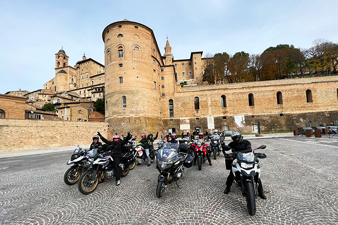
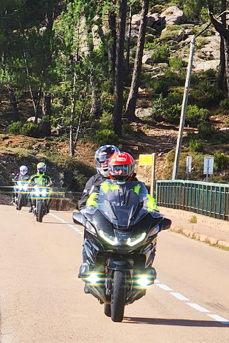
Edelweiss Bike Travel, a worldwide leader in motorcycle tours and travel since 1980, has organized an exclusive tour for Rider magazine. Join one of Rider’s editors on the Unknown Italy Tour, which reveals the secrets of the Appenines, the chain of mountains that runs down the spine of the boot-shaped country.
The 12-day vacation, which runs from Oct. 9-20, 2023, includes travel days on each end, seven riding days, and three rest days (which can also be spent riding!).
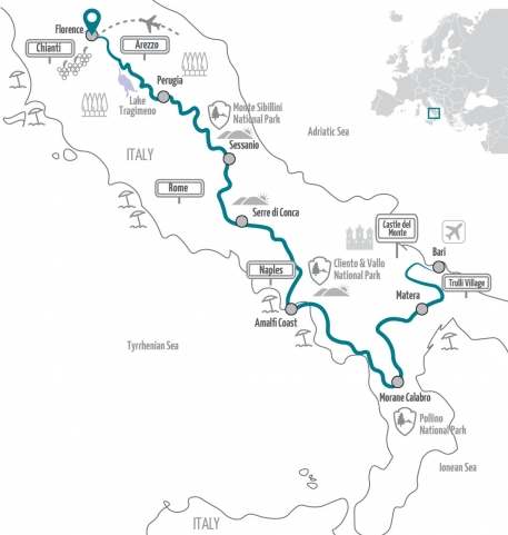
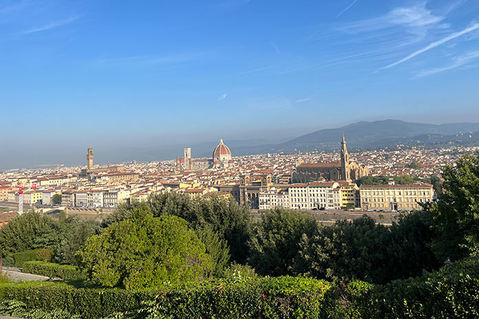
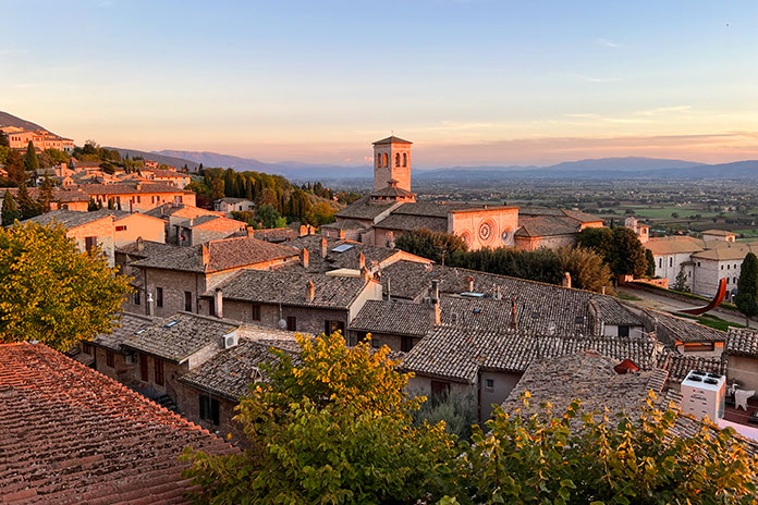
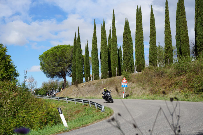
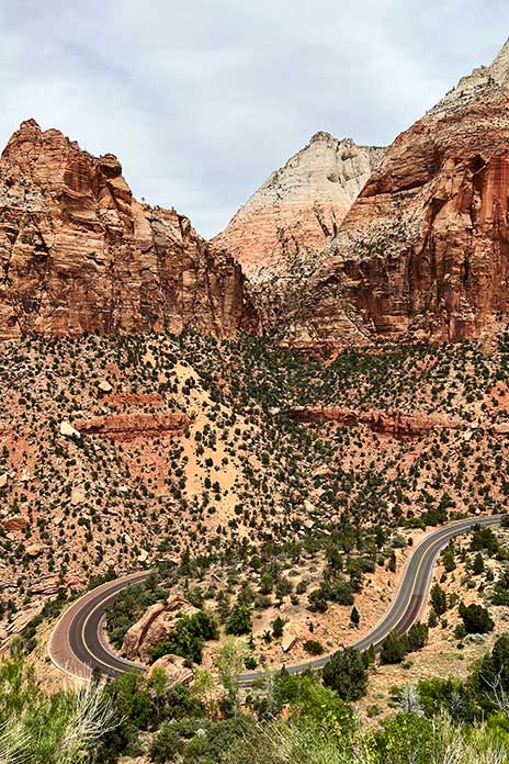
The tour begins in Florence, the capital city of the Tuscany region that’s world-renowned for its food, wine, and Renaissance art and architecture. Arrive a couple days early to allow time to visit the iconic Duomo, Michelangelo’s David sculpture, Botticelli’s “The Birth of Venus,” and da Vinci’s “Annunciation.” You’ll also want to stroll the historic streets and enjoy a gelato!
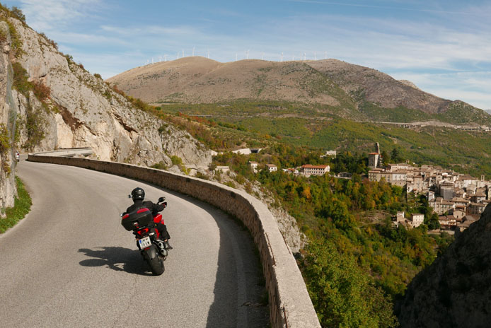
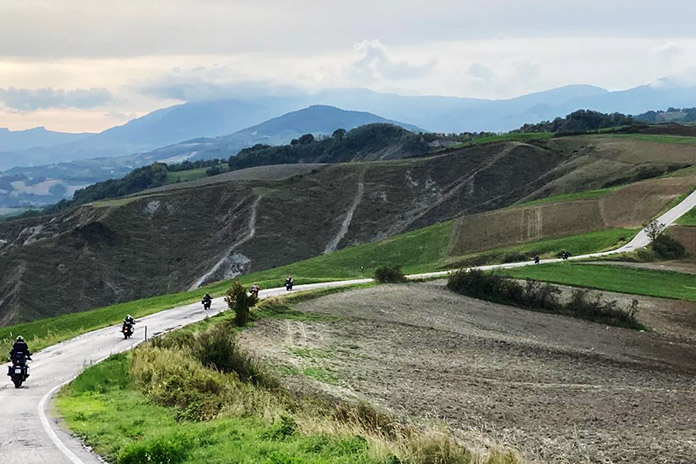
For the first two riding days, we’ll ride on twisty, lesser-known roads through the Appenines to Perugia, the capital city of Umbria that’s known for its defensive walls around a historic city center, and then it’s on to Santo Stefano di Sessanio, a medieval town located within the Gran Sasso e Monti della Laga National Park, where we’ll spend a rest day.
Next, we’ll continue riding south to spend a night in the small village of Serre di Conca, and then we’ll make our way to the legendary Amalfi Coast that overlooks the Tyrrhenian Sea and the Gulf of Salerno. A popular holiday destination, the Amalfi Coast is known for sheer cliffs, secluded beaches, and pastel-colored fishing villages.
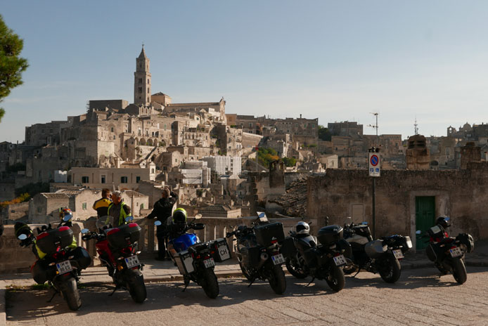
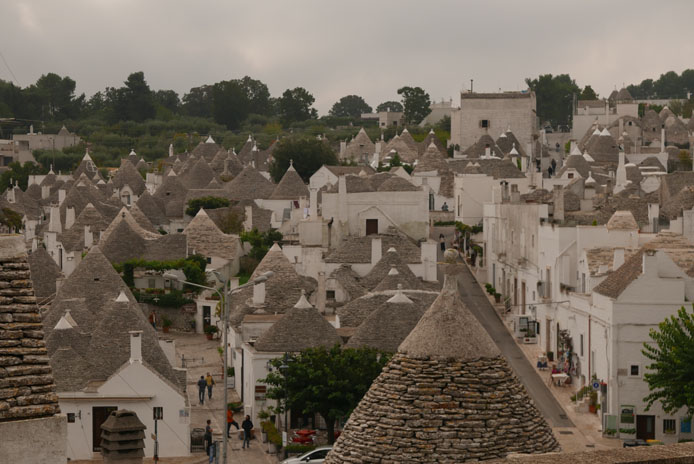
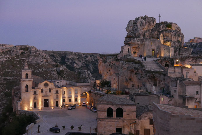
From the Amalfi Coast, we’ll explore more backroads on our way to the mountain village of Morano Calabro, which is located near a 3,600-foot pass. For the third and final rest day, we’ll ride to Matera, the European Capital of Culture for 2019. The city is perched on a rocky outcrop in the region of Basilicata, and nearby is the Sassi area, a complex of cave dwellings carved into the mountainside.
The tour concludes in Bari, a port city on the Adriatic Sea that’s the capital of Italy’s Puglia region. Bari’s mazelike old town, known as Barivecchia, occupies a headland between two harbors.
Day 6: Serre di Conca – Costiera Amalfitana (Amalfi Coast)
Day 7: Costiera Amalfitana (Amalfi Coast) (rest day)
Day 8: Costiera Amalfitana (Amalfi Coast) – Morano Calabro
Day 9: Morano Calabro – Matera
Day 10: Matera (rest day)
Day 11: Matera – Bari
Day 12: Departure from Bari
Pricing starts at $6,250 per person, including motorcycle rental for a rider in a double room (see below for what’s included in the price). See the tour webpage for tiered pricing for different motorcycle models as well as pricing for a passenger and a single room supplement.
Join one of Rider’s editors on this unique, once-in-a-lifetime motorcycle adventure. Space is limited, so make your reservation today!
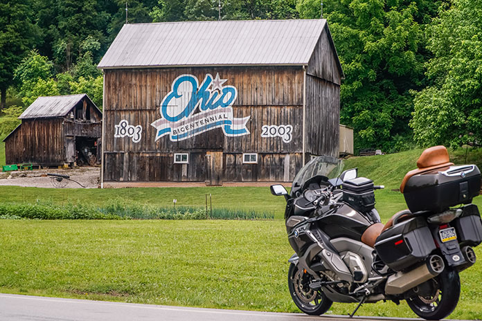
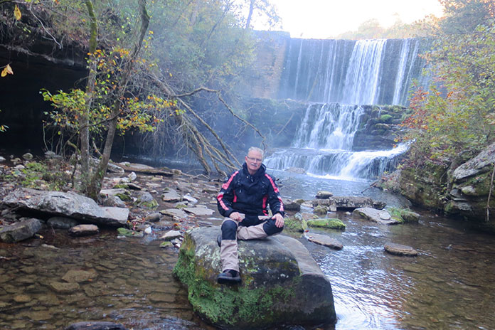
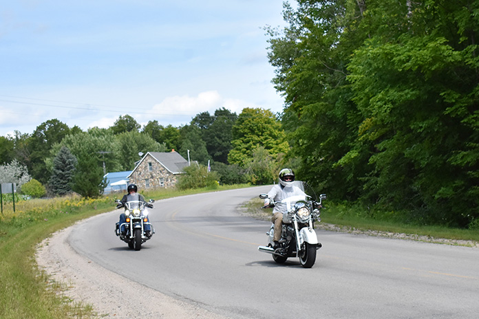
Contributor Scott A. Williams’ 2-day southeast Ohio motorcycle tour highlights some of the best Ohio motorcycle roads and includes a stay in the historic town of Marietta along the Ohio River. (Photos by the author and Greg Nebbia)
This Southeast Ohio motorcycle tour story, which highlights some of the best Ohio motorcycle roads and a stay in the historic town of Marietta on the Ohio River, first appeared in the March 2023 issue of Rider.
For riders who want to carve continual curves through forests, along rivers, and past farms, you won’t find better roads in so focused an area than in the southeast corner of Ohio. The landscape of constantly rising and falling hills results in roller coaster roads that will have you laughing with joy. The rush from blind rises, off-camber curves, and decreasing-radius corners is never-ending. Add abundant wildlife, farm vehicles, and the occasional Amish buggy to the equation and you quickly realize how crucial it is to stay laser-focused on the task at hand.
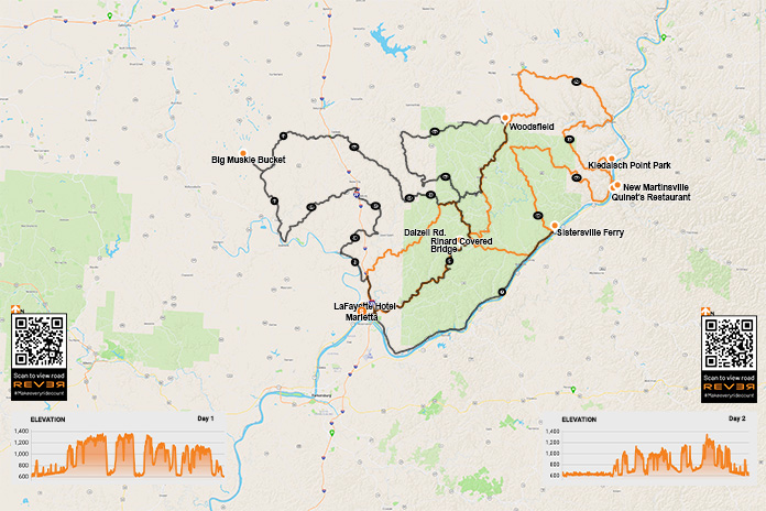
Scan the QR codes above or click here for Day 1 or here for Day 2
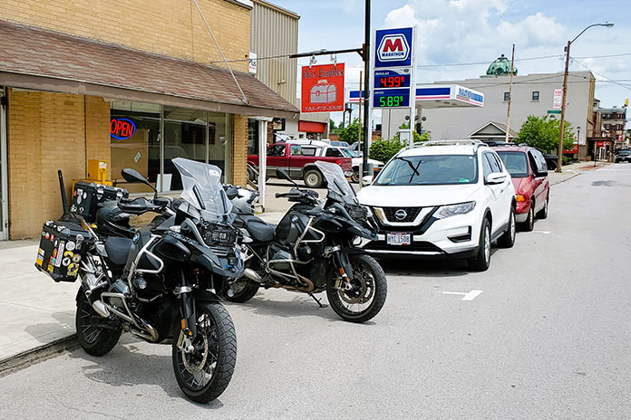
With the benefit of routes created and inspired by Ed Conde of New England Riders, many riders from the Northeast and Canada make the trek south to savor these roads. The small, historic city of Marietta on the bank of the Ohio River is an ideal base of operations for a tour of this region. We found multiple options for lodging, a lively downtown with a variety of great restaurants and pubs, and even a motorcycle shop that will come in handy if your tires lose tread faster than expected.
Our group of experienced sport-touring riders, including my good friends Steve Efthyvoulou, Randy Palmer, and Bob Holahan, confirmed a plan over breakfast and then began our day heading north and east of Marietta on Ohio State Route 821. Beyond Whipple, a right on Dalzell Road had us winding through forested hills. The constant elevation changes could be a cartographer’s worst nightmare, but they’re a motorcyclist’s dream come true. Our group was connected via bike-to-bike intercom, which enabled the lead rider to offer helpful warnings:
Wow, this curve tightens fast!
Watch for gravel in that right hander.
The road drops left after that blind rise … weeee!
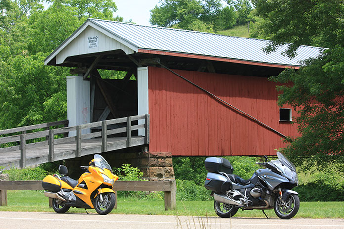
Rinard Covered Bridge along Ohio State Route 26 in Wayne National Forest is the third covered bridge built at this location, the original dating to 1875.
At State Route 565, we turned right, curved past Zwick Park, then headed south on State Route 260 through Quarry and to New Matamoras. The curves were incredible! At State Route 7, we turned left toward the township of Fly, then left on State Route 800 back up into the hills. Beyond Jackson Ridge Church, we turned right on State Route 255 to Laings, then stayed on 255 back to Sardis and Route 7.
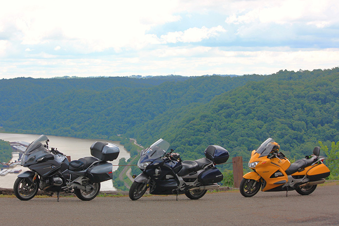
Route 7 is designated the Ohio River Scenic Byway. Scenic, yes, but it’s mostly flat and lacks challenging curves. However, it was useful for taking us to the next incredibly curvy road up into the hills: State Route 536 in Hannibal. A short diversion onto Long Ridge Road and Short Ridge Road brought us up to Kiedaisch Point Park. From there we enjoyed the vista overlooking the Hannibal Locks and the bridge crossing the Ohio River to New Martinsville, West Virginia.
Hannibal Locks and the bridge over the Ohio River to New Martinsville, West Virginia, viewed from Kiedaisch Point Park in Clarington, Ohio.
With our stomachs signaling lunch, we decided to cross that bridge and found Quinet’s Restaurant. The buffet is extensive, and an impressive display of local history covers the walls of this New Martinsville institution. Appetites satisfied, we crossed back into Ohio and picked up State Route 536 all the way to State Route 78, where turning right put us on a parallel track with Sunfish Creek, which meanders and then widens before emptying into the Ohio River at Clarington. Route 7 sent us to State Route 556 where we turned to enjoy more curves all the way to Beallsville and State Route 145.
Morning breaks on the Ohio River in Marietta, Ohio.
At Jerusalem, a left pointed us south on State Route 26, the National Forest Covered Bridge Scenic Byway. For most of its length, the byway parallels the Little Muskingum River, and we happened upon Rinard Covered Bridge. It’s the third covered bridge to be constructed on this location, the original dating to 1875. On these winding southeastern Ohio roads, shoulders vary from narrow to nonexistent, so this stop was noteworthy because it was a chance to pull safely off the road to shoot photographs. Continuing on Route 26 provided us miles of smiles back to Marietta.
With constant curves and limited sight distances, places to stop safely along the roadside are few and far between in southeastern Ohio. One solution – just keep riding!
The mental focus required to follow all these curves, coupled with the physical demands of countersteering and shifting body position on heavy sport-tourers, had us feeling tired at the end of the day. After returning to Marietta, we walked to Tampico Mexican Restaurant and rehashed a fantastic day over a relaxed meal and a pitcher of margaritas.
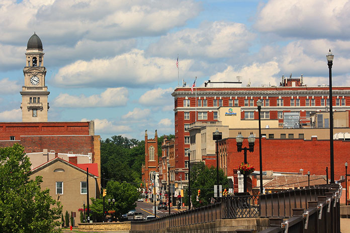
A beautiful June afternoon finds downtown Marietta looking its best. The charming little town served as an ideal base for our two days of sport-touring in the hills of southeastern Ohio.
Your humble scribe is an early riser, so the next morning as the sky began to lighten, I set out to explore more of downtown Marietta. Reading the many historical signs, I learned that pioneers established the town in 1788 as the first permanent white settlement of the United States Territory Northwest of the River Ohio. Many original settlers were Revolutionary War officers who were offered land grants as compensation for military service. Artisans from my native New England also settled here, bringing with them skills that helped Marietta quickly become a center for shipbuilding. Between 1800 and 1812, nearly 30 ocean-going vessels were built here in eight shipyards.
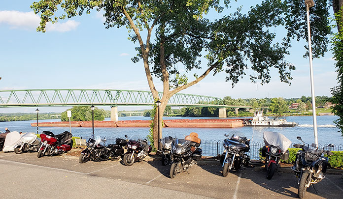
Commercial barge traffic is ubiquitous on the Ohio.
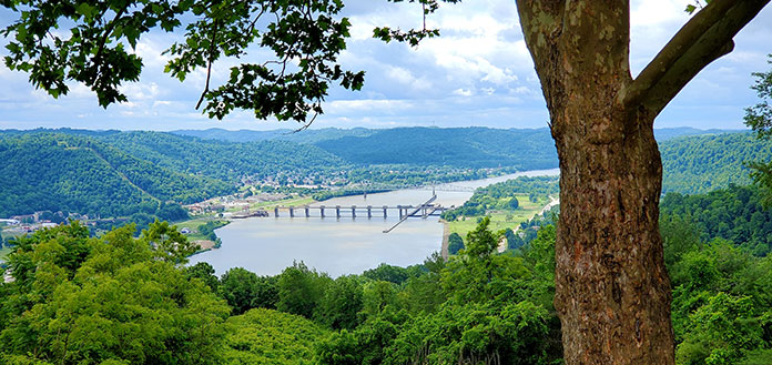
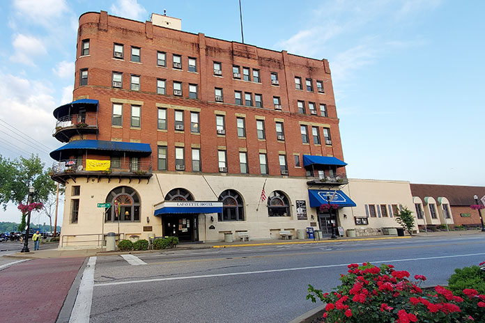
Another piece of riverfront history is the place where we stayed, the Lafayette Hotel (c. 1918). Inside, the hotel’s lobby feels like a formal parlor. Realtors might describe the rooms as “quaint” and “cozy,” with the period furnishings and fixtures including styles long forgotten by interior designers. Our tidy room overlooked the Ohio River, the Highland Avenue Bridge, and lovely riverside homes on the opposite riverbank in Williamstown, West Virginia. Even the parking area for our bikes overlooked the river. Modern-day riverboats still dock at that very spot, as one did during our stay, so it’s fitting that this lodging retains the feel of the riverboat era.
The historic Lafayette Hotel in Marietta overlooks the confluence of the Muskingum and Ohio rivers.
After breakfast at the hotel, our group was ready for another day behind the handlebars. Since any road is different in the opposite direction, we began by reversing course on one of our favorites from the day before, Route 26. The weather was perfect, and we enjoyed glimpses of the scenery when we could divert our attention briefly from the curvaceous road. In Woodsfield, we found Ida’s Lunchbox, which other riders had recommended, and enjoyed a light lunch and conversation, while a farmer at the next table listened attentively to the agriculture report on TV.
Ida’s Lunchbox in Woodsfield is a popular spot with riders. These BMWs were part of another group exploring the curve-rich environment.
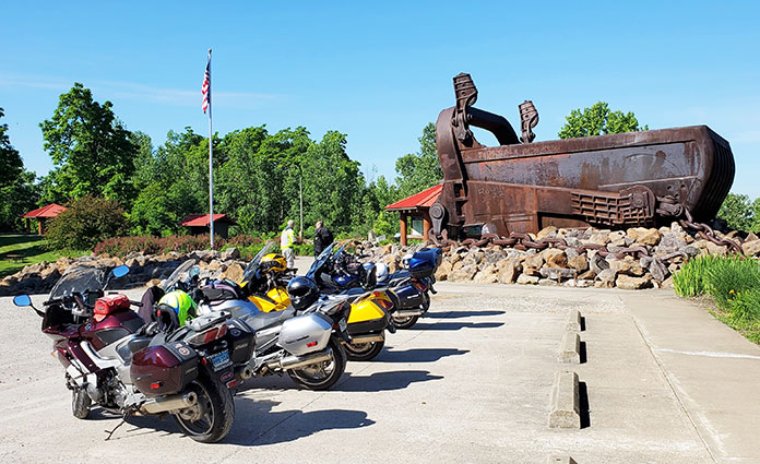
We continued on 26 to Jerusalem, turned west on State Route 145, kept twisting southwesterly along Duck Creek to Lewisville, and then took State Route 724 west to Carlisle. A different stretch of Route 260 wound us south along East Fork Duck Creek to Harriettsville. Just past town, we turned right on State Route 564 and began to follow Middle Fork Duck Creek to Caldwell. State Route 78 took us out of town and curved to a highlight of the day: Big Muskie Bucket, the business end of one of the largest machines ever to move on land.
Big Muskie was a walking dragline designed to remove earth and uncover a coal seam that lay 180 feet below the surface. This colossal machine was electric, powered by a 13,000-volt “extension cord,” and so enormous it’s hard to wrap your brain around the scale. It was 1.5 times longer than a football field, more than 222 feet tall, and weighed 12,000 tons. The bucket, which weighs 210 tons when empty, could grab 325 tons of earth in a single “bite” and hold 220 cubic yards. In 1969, the entire Morgan High School Marching Band, nearly 50 members strong, played inside the bucket at Big Muskie’s inaugural ceremonies. By 1991, more efficient mining methods and increasingly stringent environmental regulations sidelined Big Muskie. Now the bucket is all that remains, rusting away in a park on Route 78 near Bristol.
Pedestrians and a flagpole hint at the scale of the Big Muskie Bucket. It’s HUGE.
We briefly reversed course on 78 to State Route 83 and headed south for gentler curves down to Beverly. There, a left on State Route 339 moved us into farm country and past Crooked Tree. A right on State Route 821 had us paralleling Duck Creek through Macksburg, Elba, and Warner. A right on State Route 530 delivered the day’s last dose of twisties down to Lowell, where leisurely State Route 60 returned us to Marietta.
Bikes have an even better view of the Ohio River than we had from our hotel room.
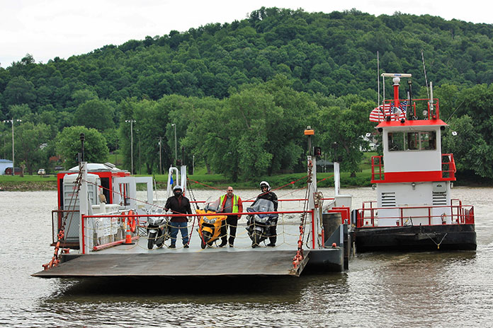
One thing we had missed thus far was a ferry ride, so we made a quick run up Route 7 to the Sistersville Ferry, which has carried people across the Ohio River between Fly, Ohio, and Sistersville, West Virginia, for over two centuries. Several types of ferry have been used throughout the company’s history, and the one currently in use is a type none of us had seen before. Vehicles drive onto a ferry barge, which is propelled through the water by a tug. The barge is double-ended so it doesn’t have to change direction with each river crossing, but the tug needs to turn around after each landing. The tug’s bow is attached to the barge’s side via a pivoting mechanism that resembles an automotive trailer hitch. When the ferry reaches the other side, the captain simply pivots the tug 180 degrees to cross the other way. Pretty slick.
Bob, Randy, and Steve patiently await their arrival in Fly aboard the tug-driven Sistersville Ferry.
After the ferry, we made our way back to Marietta, where our dinner spot was a short stroll through Ohio Riverfront Park to Levee House Bistro for, of all things, lobster – prepared by a chef from Boston no less!
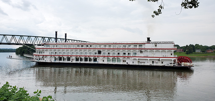
The riverboat American Countess prepares to dock by the Lafayette Hotel in Marietta.
Commitments back home had us heading east the next morning, but we plan to return to this region for more great riding. To the north is State Route 555, the renowned “Triple Nickel” (see Ken Frick’s story “Riding Ohio’s Triple Nickel”). To the west are gentler curves leading to Hocking Hills State Park, where riders can enjoy some of Ohio’s best scenery and stretch their legs on short hikes. The hilly landscape is much the same on the West Virginia side of the Ohio River, with roads such as West Virginia State Route 20 from New Martinsville to Mannington and U.S. Route 250 from Mannington to Moundsville, keeping riders on their toes and making joyful noises.
If you prefer roller coaster rides that you control, a motorcyclist’s amusement park awaits you in southeastern Ohio.
Our big Singles on a one-lane bridge over Little Piney Creek near Highway 123.
As the saying goes, it’s the journey and not the destination that makes the trip. But how does one describe a destination that is as good as it gets and an even better ride? With autumn upon us, it was the best time – and maybe our last chance – for riding the Ozarks before winter.
Big Singles are a great way to travel, especially if you’re not in a hurry. That made them perfect for our trip because the route I chose demands backing off the throttle to see the sights and make the corners.
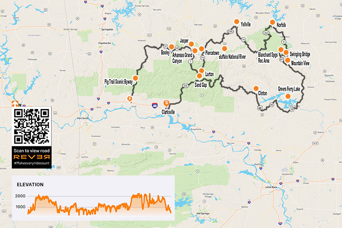
Our counterclockwise route began in Clarksville, Arkansas, riding northbound briefly on Highway 21 and then turning east on Highway 292 to connect with Highway 123, a great road that climbs into the mountains through the Ozark-St. Francis National Forest. Highway 123 follows Little Piney Creek and then Hew Creek, and there are scenic waterfalls along the way.
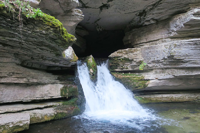
Water pouring out of Blanchard Springs Caverns near Mountain View, Arkansas, in the Ozark-St. Francis National Forest.
At Sand Gap, Highway 123 connects with Highways 7 and 16. We continued east on Highway 16, which is a pleasure to ride, with the kind of tarmac that offers confidence-inspiring traction in its many curves, even with our dual-sport tires.
At Clinton, we rode south on U.S. Route 65 and then followed Highways 92 and 16 around the south side of Greers Ferry Lake, turning north on Highway 5 near Heber Springs.
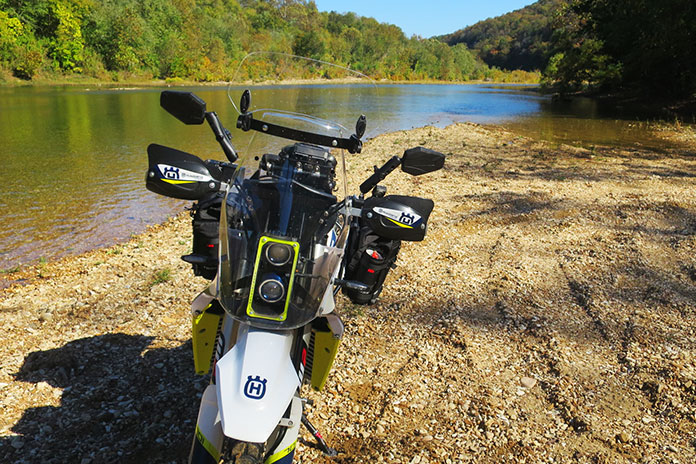
My adventure-kitted Husqvarna 701 Enduro near South Sylamore Creek, which is a popular trout-fishing stream.
Our first day’s destination was Mountain View, a small town of 2,900 people that’s surrounded by the Ozark Mountains and close to the gorgeous White River. It’s also known as the “Folk Music Capital of the World.” During the summer months, folk and country music groups gather in the city park, providing family entertainment well into the night, especially on Saturdays. In the spring and fall, when the nights are too cool for the musicians’ fingers to pluck their stringed instruments, they play in the afternoons. It’s a popular attraction, so make your hotel reservation well in advance. As you might expect, there’s not much pickin’ and grinnin’ in the winter.
From Mountain View, we rode north on Highway 5, and just before the junction with Highways 9 and 14, we turned left on Swinging Bridge Road, named after the cable-suspended wooden bridge over the crystal-clear South Sylamore Creek. Just west of the bridge, mountainous Highway 14 took us to the Blanchard Springs Recreation Area with its springs, caverns, and cliffside hiking trails. Mirror Lake, popular for its rainbow trout, is fed by the cold water from Blanchard Springs. Near the lake, one can hike a wooden walkway and down stone steps to where the spring comes out of the caverns. Pretty cool. Below the Mirror Lake dam, another trail takes you to the remains of a corn mill built in the early 1900s and the bottom of Mirror Lake Falls.
Mist rises off Mirror Lake at sunrise.
On the map, Highway 87 looked like it would be fun, so we rode it back to Mountain View. It was a good choice!
From Mountain View, we again rode north on Highway 5 along the lovely White River and through charming places like Calico Rock, Old Joe, and Norfork. A short hop west on Highway 201 took us to the sweeping curves of Highway 341 (Push Mountain Road) into the Leatherwood Wilderness area.
Swinging a leg over the tall Husky on the cable-suspended wooden Swinging Bridge, which spans South Sylamore Creek just north of Mountain View.
At Highway 14, we turned west again and crossed Big Creek and the Buffalo River. If you ride through here during hot weather, the Buffalo is a great place to cool off, with parking and access at Dillard’s Ferry.
Just south of Yellville (if you cross Crooked Creek, you’ve gone too far), we turned west on Highway 235 and rode south until it ended at U.S. Route 65. We continued west, turning onto Highway 123 again near Western Grove and riding south. We crossed the Buffalo River again just before we got to Piercetown.
Located in the Blanchard Springs Recreation Area, Mirror Lake Waterfall pours over a dam built by the Civilian Conservation Corps in the 1930s.
Rather than ride a short 10 miles west on Highway 74 to Jasper, we continued south on Highway 123 through what’s known as the Arkansas Grand Canyon, taking the long way to Jasper via Highway 7. After only a few miles on Highway 123, my Husky’s low-fuel light lit up, but we were still some 45 miles from “good” gas in Jasper. I asked myself, Should I stop at the one gas station on 123 and put low octane in my thumper or chance it and go for the good stuff? I chose the latter – and ran out of gas just 7 miles south of Jasper. Next time I’ll know: A gallon of cheap gas is better than none at all! Bill’s KLR had just enough fuel left to get him to Jasper, and after a short roadside nap, we were off again.
Jasper is a lovely little town, and just north of it, after crossing the Buffalo again, is Highway 74, an often overlooked but fantastic motorcycling route. We rode it west to Highway 43 – famous for elk sightings – and then west on Highway 21 and south on 74 again.
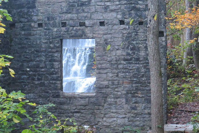
What looks like a portrait on a stone wall is Mirror Lake Waterfall as seen through a window.
Highway 74 connected us to the famous Pig Trail Scenic Byway (Highway 23). Feeling bolder than I should have, I tried to use the Husky’s superior power to pull away from Bill’s KLR, but he stretched the KLR’s throttle cable and hung with me. As fast as we dared go, some guy on a multi-cylinder crotch rocket blew by us and out of sight. One good thing about riding a thumper is that you feel like you’re going fast when you really aren’t.
The Buffalo River and an adventure bike go together nicely, don’t ya think?
Highway 23 dropped us down out of the Ozarks onto Interstate 40 and then back home to Oklahoma.
Riding big Singles for 650 miles in two days wasn’t bad at all. In fact, in the mountains of Arkansas, it was big fun.
It doesn’t get much better than a scenic ride with friends on a bluebird day. (Photos by Kathleen Currie and Corey Aultman)
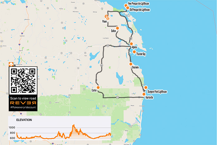
At first glance the small farming town of Posen, which is situated along State Route 65 in northeastern Michigan and hosts an annual Potato Festival, doesn’t appear to be a logical meet-up spot to kick off a daylong motorcycle tour. But the Route 65 Diner offers up classic breakfast and lunch fare, the nearby Posen EZ Mart is a convenient place to fill up, and the village is near Lake Huron, the second largest of the Great Lakes, so it’s perfect starting point for a Lake Huron lighthouses loop.
This scenic route through the northeast corner of Michigan’s Lower Peninsula is about 180 miles and provides a leisurely day of riding with stops for sightseeing and food. It offers unique historical sites, lighthouses, shipwrecks, wildlife sanctuaries, parks and beaches on Lake Huron, and paved roads through deep timber forests.
The ride is best done between Memorial Day and Labor Day but could be done earlier in the spring or later in the fall depending on the weather. We took our ride in September.
About 5 miles north of Posen, Route 65 dead-ends at U.S. Route 23, which runs along the edge of Lake Huron’s Michigan shore from Mackinaw City to Saginaw. We headed east on Route 23 and soon entered Thompson’s Harbor State Park. We turned onto Old State Road, followed it to the end, and went north on East Grand Lake Road, which took us onto a narrow peninsula that juts into Lake Huron between North Bay and Presque Isle Bay.
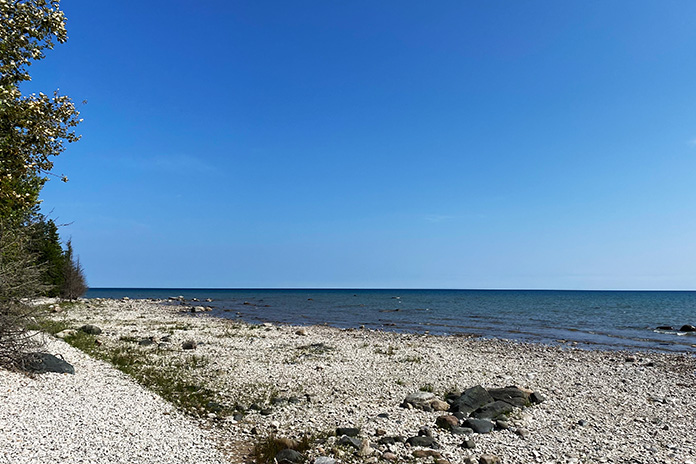
Covering just over 23,000 square miles, Lake Huron is the third largest freshwater lake in the world. Somewhere out in the distance is Canada.
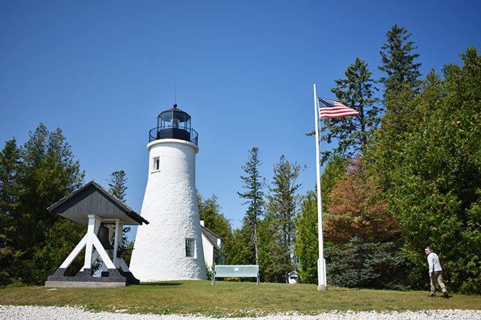
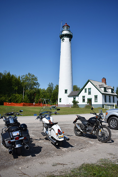
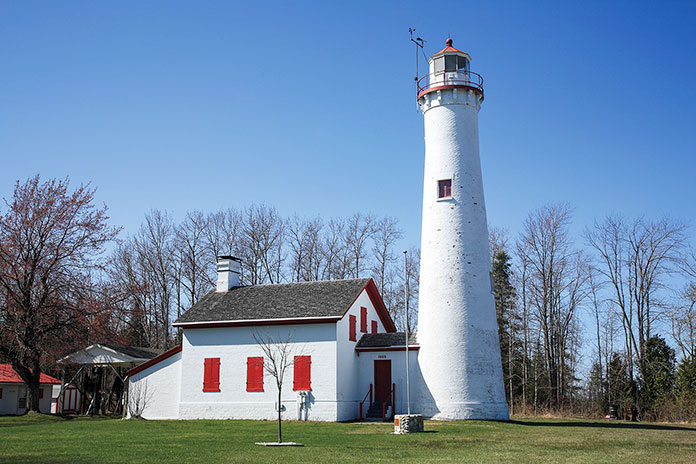
On the right, we saw the Old Presque Isle Lighthouse, which was built in 1840. Due to the harsh weather on Lake Huron, the original lighthouse deteriorated, and the New Presque Isle Lighthouse was built in 1870 farther north near the end of the peninsula. Standing 113.5 feet tall, it is one of the tallest lighthouses on the Great Lakes. Both lighthouses have been restored and are part of a 99-acre park that includes a playground, picnic area, pavilion, gift shop, museum, and nature trails.
The New Presque Isle Lighthouse and keeper’s house.
Adjacent to the New Presque Isle Lighthouse is a keeper’s house that was built in 1905 and is now a museum. Admission is free, but we paid $5 to climb the 130 steps to the top of the lighthouse for excellent views of Lake Huron and the Presque Isle area. The buildings and grounds are open to the public daily from mid-May through mid-October.
We returned to U.S. Route 23 and rode south, finding a few curves along the edges of Grand Lake and Long Lake, which are just inland from Lake Huron. We made our way to Alpena, a town of about 10,000 residents that sits on the northern shore of Thunder Bay. Nearby are two lighthouses, but they are out in the lake on islands and only accessible by boat.
The Harley and Indian riders in our group searching for a lumberjack breakfast.
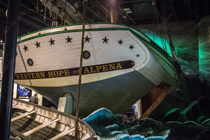
The Thunder Bay National Marine Sanctuary protects an area of Lake Huron known as “Shipwreck Alley” where there have been more than 100 historically significant shipwrecks. Some of the wrecks are close enough to the surface for sightseeing, which we did on a two-hour shipwreck tour on a glass-bottom boat called the Lady Michigan. We also visited the Great Lakes Maritime Heritage Center, a museum with exhibits and pieces of boats that washed ashore.
The Great Lakes Maritime Heritage Center in Alpena is a large museum that includes a shipwreck gallery, a theater, and an archeological lab. (Photo by ehrlif – stock.adobe.com)
When we left the museum, the Royal Enfield and Triumph riders in our group insisted we check out a British tavern in downtown Alpena called the Black Sheep Pub. It is decorated with British flags and memorabilia, and the menu includes rich and tasty pub grub like fish and chips, a pork burger drizzled with vinegar, Scotch eggs, and pickled chips.
After lunch, we continued south on Route 23 through parts of Thunder Bay River State Forest, Au Sable State Forest, and Huron National Forest. This is chainsaw country. In Ossineke, we passed colorful concrete statues of Paul Bunyan and Babe the Blue Ox built in the 1940s by Paul Domke, who also built the creatures in the nearby Dinosaur Gardens Prehistoric Zoo.
Cruising through some gentle curves in Huron National Forest.
South of Alcona, we visited Sturgeon Point Lighthouse, which was built in 1870. The 70-foot lighthouse is maintained by the U.S. Coast Guard and is open to the public. The keeper’s house is a maritime museum open from Memorial Day to mid-September.
At Harrisville, the Harley and Indian riders in our group made it known that it was time for some American food. We rode west on State Route 72 into the heart of Huron National Forest and then turned north on State Route 65 to Curran. Just north of town, we stopped at the Lunch Block and had a proper lumberjack breakfast.
Full from our hearty meal, we further compressed the suspension of our motorcycles and continued north on Route 65 through a section of forest so dense that no paved roads cross to the east. Werth Road finally appeared and provided a paved route with a few curves back to Alpena. Alternatively, you can continue north on 65 and turn east on State Route 32.
Just north of Alpena, past the wildlife sanctuary, we picked up Long Rapids Road, which meanders along the Thunder Bay River heading northwest to the town of Bolton. We continued north on Bolton Road, then west on Long Lake Highway, and finally back onto Route 65 for our return to Posen.
If Michigan is in your motorcycle travel plans, check out the northeastern part of the state near the Lake Huron shore. The roads provide scenic views of the lake and some mellow curves and hills, and the lighthouses and historic sites are a nice diversion when it’s time to stretch your legs.
Following the success of the first partnership between BMW Motorrad USA and Backcountry Discovery Routes in 2022 with the Wyoming BDR, the two groups have announced a second partnership for a route in Oregon. The new route will be officially launched Saturday, Feb. 4, at the premiere screening of the ORBDR Expedition documentary in Portland and other select locations around the nation. For more information, read the press release below from BMW Motorrad USA.
BMW Motorrad USA is excited to announce its second partnership with adventure motorcycling nonprofit, Backcountry Discovery Routes (BDR) on their newest route – Oregon. This is the second BDR route on which BMW Motorrad has collaborated, the first being the Wyoming BDR, released in 2022.
The ORBDR represents the organization’s 12th route for adventure and dual-sport motorcycle travel, with free GPS tracks, travel resources, and a Butler Motorcycle Map scheduled to accompany the film’s debut.
Luciana Francisco, BMW Motorrad USA head of brand and marketing, said BMW Motorrad is proud to partner with Backcountry Discovery Routes for the second time in two years.
“In 2023, BMW Motorrad celebrates its 100th year anniversary and also marks 43 years of BMW GS motorcycles,” Francisco said. “This is the perfect time to share our passion for the adventure and dual-sport riding communities and show our continued support for the BDR organization and what they stand for. We look forward to both new and experienced off-road enthusiasts being inspired by the scenic routes of the ORBDR.”
To launch of the new Oregon route, Backcountry Discovery Routes and BMW Motorrad will kick-off with a film premiere event in Portland, Oregon, and selected BMW Motorrad dealer events on Saturday, Feb. 4. Additionally, over 70 film screenings are planned through spring 2023, hosted by dealers and clubs around the country. More information on the film screening locations is available at the Backcountry Discovery Routes events webpage.
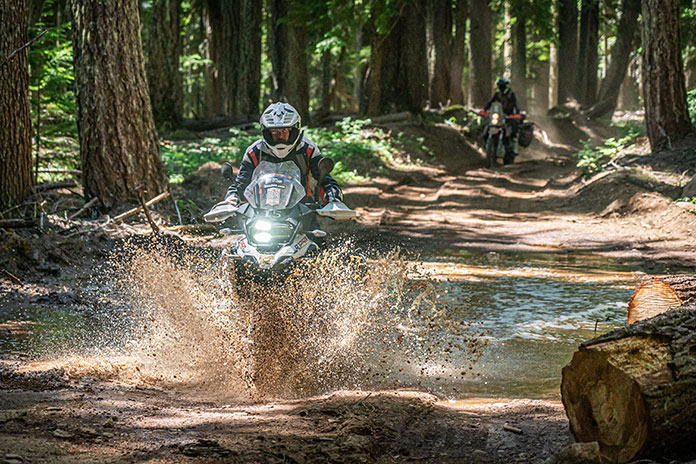
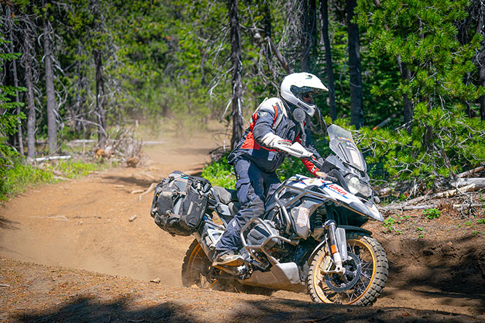
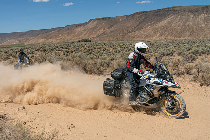
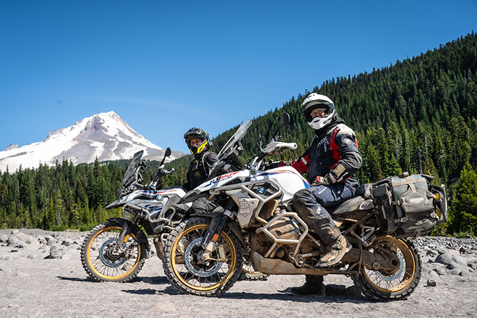
The ORBDR expedition film features members of the BDR team and special guests from BMW Motorrad USA, Mosko Moto, and Edelweiss Bike Travel as they take a first run on the all-new ORBDR. Starting in the high desert landscapes of Southeastern Oregon and exploring North into the Cascade Range, the crew tests their endurance, riding cross-state through 750 miles of lava rock, silt, sand, and steep mountain roads. Highlighting the state’s many natural wonders including hot springs, pyroducts, caverns, buttes, and glaciated volcanoes, the route and film showcases why traveling by motorcycle is one of the best ways to discover the backcountry of Oregon.
Story continues below trailer for ORBDR Expedition
Bryce Stevens, Oregon Route architect & BDR co-founder grew up in the Pacific Northwest and said he has “always been fascinated by volcanoes.”
“The ORBDR is a route filled with natural wonders of the volcanic kind. We designed the ORBDR to show off different regions of the state and keep the route ever-changing,” Stevens said. “Oregon has vast high desert in the southeast, sparse pine forests in the central part of the state, and densely forested mountains in the Cascade Range. It almost feels like three BDRs packed into one.”
Joining the expedition team in Oregon was Ricardo Rodriguez, lead motorcycle instructor at BMW’s U.S. Rider Academy in Greer, South Carolina. Ricardo is a graduate of BMW’s rigorous International Instructor’s Academy and has been teaching on-road street survival, adventure off-road, and authority riding skills since 2010.
“The BDR Team has set out on a fantastic mission, helping keep public lands accessible to the adventure community,” he said. “I am very proud and excited about the relationship between BDR, BMW Motorrad, and the BMW U.S. Rider Academy. Having the opportunity to be a part of the Oregon BDR has helped build my experience as a rider and a coach. Overcoming the challenges along the ORBDR reinforced to me the value of the skills we teach daily at the US Rider Academy.”
Rodriguez continued to say that Backcountry Discovery Routes offers properly trained riders an opportunity to put their skills to the test.
“The Oregon BDR is a challenge and reward riding adventure.”
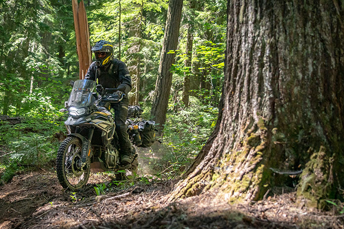
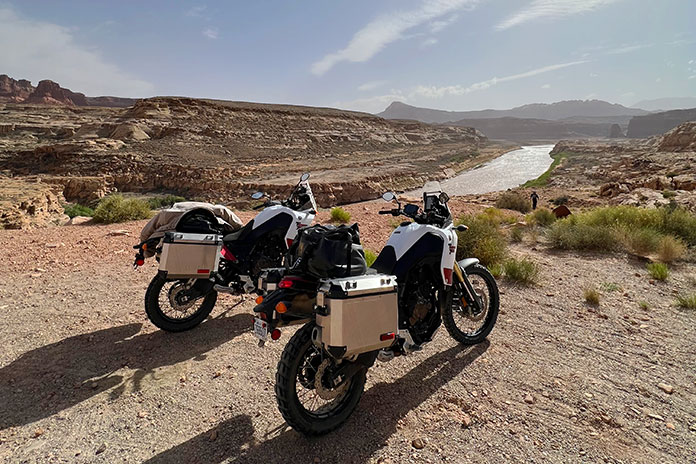
Taking a rehydration break along the Colorado River while our Yamaha Ténéré 700s waited patiently.
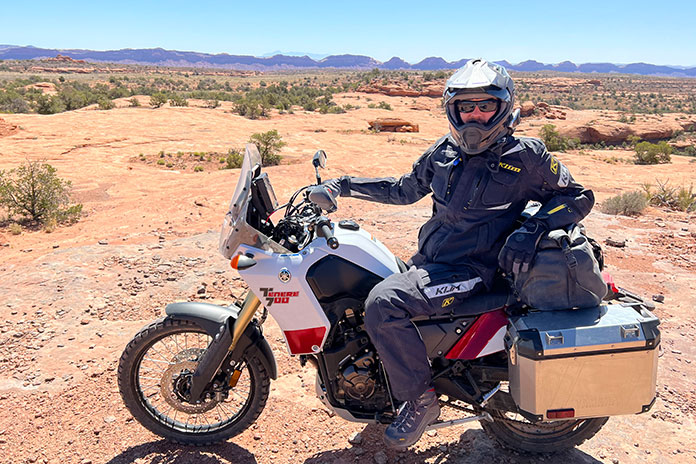
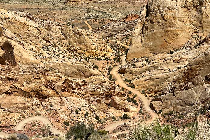
During the long, dark winter in Minnesota, when the ground is covered in snow and ice and our motorcycles are mothballed for months, dreaming about riding in a warm, dry place gives us hope. That’s when my friend Craig and I started planning an adventure ride out West. We sketched out a route that included a mix of backroads, parts of the Arizona and Utah Backcountry Discovery Routes, other off-road tracks, and interesting sights along the way.
In May, we flew into Phoenix and headed to EagleRider in nearby Mesa, where we were greeted by a friendly guy named Bob. After a quick paperwork checkout procedure, we packed our gear on two rented Yamaha Ténéré 700s and headed north on Interstate 17.
With temperatures in the triple digits, the frigid days of winter seemed like a distant memory, so we busted north to gain some elevation.
Even in full riding gear, we started to cool off as we rode farther north. Our bikes were unfamiliar to us, and they were stuffed to the gunwales with camping gear and other essentials. We soon grew accustomed to their added weight as we passed over the “Carefree Highway,” a 30-mile stretch of road made famous by Canadian singer Gordon Lightfoot that runs between I-17 and U.S. Route 60.
I have a lot of street miles under my belt, but this was my first adventure bike trip, so I wasn’t entirely prepared for the primitive roads where the gravel feels like marbles under your wheels. However, it didn’t take long for the combination of my ancient dirtbike experience and a few unplanned rear-wheel kickouts to provide a quick education on keeping the Ténéré upright. Enthusiasm tempered with caution was the order of the day.
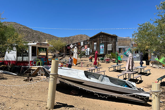
We took County Road 59/Bumble Bee Road off I-17 to check out the Cleator Bar and Yacht Club. The name of this welcoming 4×4 oasis run by Tina Barnhart is a bit tongue-in-cheek, as it is located hundreds of miles from open water. Barnhart is also in the vehicle delivery business to such faraway places as Africa and is active in the Global Rescue Project based in Scottsdale, Arizona, which works to end child slavery and reunite children with their families.
Boats in the Yacht Club’s “marina.”
The Cleator Bar is a must-stop location, complete with boats in the “marina” out back and a stage for live music. Interestingly, the entire town of Cleator, comprising 40 acres, a bar, a general store, a few other structures, and mineral rights, was put on the market by descendants of James P. Cleator in 2020 for $1.25 million, and it was sold at the bargain price of $956,000.
Hanging out with Tina Barnhart while we cooled off at the Cleator Bar and Yacht Club.
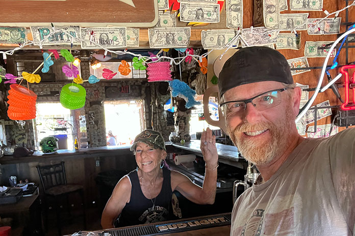
Our next stop was Crown King, located another 13 miles along CR 59 at an elevation of 5,771 feet. A high-clearance four-wheel-drive vehicle is recommended on the deteriorated roads. The Ténérés managed well, and we soon found ourselves taking a load off in the Crown King Saloon & Eatery, one of the oldest continuously operated saloons in the state. We enjoyed a cold drink and a hearty lunch, and the $5 bottle of scotch we bought there (on sale courtesy of Mother’s Day) served us well during the rest of the trip.
We were surprised to see so much green in the Bradshaw Mountains.
Like a lot of small towns in the Bradshaw Mountains of Arizona, Crown King used to be a thriving mining community. In 1904, a railroad was built to help mining operations, but due to a lack of water and high transportation costs to process the ore, it was abandoned in 1926. The old railroad bed is still used today as the main access road to Crown King.
While there, we met Chuck Hall, who is a great ambassador for the area – and a talented guitar picker to boot. He told us he’d lived there for over 30 years and recommended we check out the Senator Highway, on which he’d lost many an exhaust pipe from his old Dodge Neon. A former stagecoach route, the rutted road snakes 37 miles from Crown King to Prescott with many blind switchbacks, eroded surfaces, several water crossings, and spectacular scenery.
Craig takes a breather on part of the Utah Backcountry Discovery Route.
Hall recommended we visit Palace Station, a stage stop built in 1878 midway between Crown King and Prescott. Back in the day, the station had a bar and was a social meeting center for the miners who worked in the area.
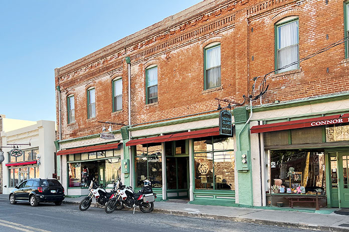
We targeted the town of Jerome for the night. This old copper mining town earned its nickname, “Wickedest Town in the West,” during its heyday in the early 20th century. After the mining bust, the town descended into desperation, greed, and crime. It was revived in the 1960s as a tourist destination, and many of its historic buildings are now filled with restaurants, shops, and hotels. Jerome is said to be a hotbed of paranormal activity, and we stayed at the Connor Hotel, which is reportedly haunted by the “Lady in Red.” We didn’t see any ghosts, so maybe she had the night off.
Downtown Jerome, the “Wickedest Town in the West.”
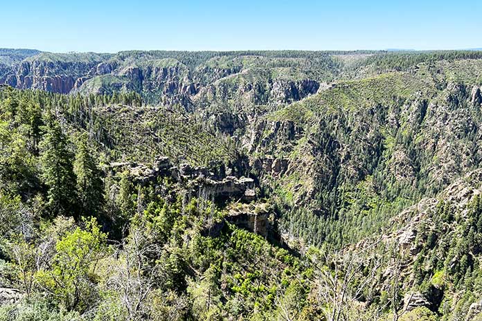
With a long day of off-roading ahead, we left Jerome and headed north toward the Grand Canyon on a series of unpaved national forest roads. We wound our way around the contours of Woodchute Mountain, crossed the Verde River, and ascended to the Colorado Plateau at more than 6,000 feet. We could see the volcanic San Francisco Peaks rising above the plateau to the east.
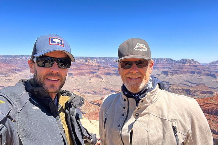
We crossed Interstate 40 near Williams, and after a few miles on State Route 64, we turned onto a national forest road to take an unpaved “back door” route into Grand Canyon National Park. We hooked up with Route 64 again where it’s known as East Rim Drive and enjoyed scenic views from the Grand Canyon’s South Rim.
Craig (on left) and me at the South Rim of the Grand Canyon – a million miles away from our home in Minnesota.
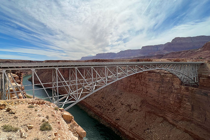
After leaving the park, we connected with U.S. Route 89 and refueled at Cameron, where the highway crosses the Little Colorado River. At Bitter Springs, U.S. 89 splits to the east toward Page, but we continued north on U.S. Route 89A, crossing the Colorado River at Marble Canyon via the Navajo Bridge and following 89A west into an area known as the Arizona Strip. We rode with the majestic Vermilion Cliffs to our right, crossed House Rock Valley, and then climbed out of the desert and into the evergreens of the Kaibab Plateau.
The Navajo Bridge crosses the Colorado River at Marble Canyon, and in the background is Vermilion Cliffs National Monument.
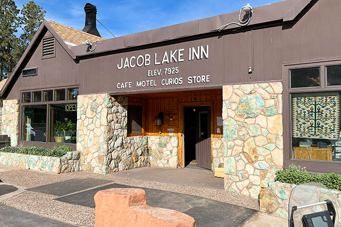
We stopped at Jacob Lake, a small crossroads that sits at 7,925 feet, and it was noticeably cooler at the higher elevation. Known as the gateway to the North Rim of the Grand Canyon, Jacob Lake has a gas station and a hotel with a restaurant and gift shop. The town was named after Jacob Hamblin, an early Mormon pioneer who was shown the location in the mid-1800s by the Kaibab band of Southern Paiutes. And according to the hotel staff, the lake is more of a pond.
Jacob Lake, Arizona, is near the North Rim of the Grand Canyon.
We continued west through Fredonia and crossed into Utah near Kanab, known locally as “Little Hollywood” because of its rich history in filmmaking – most notably Westerns, with more than 100 movies and television shows being filmed there.
Thus far we had stayed at motels, so we weren’t exactly roughing it. We decided we needed to get some use out of the camping gear we’d been lugging around. After riding through Zion National Park, where we were blown away by the majesty of the cliff faces and rock formations, we traversed the Dixie National Forest through Duck Creek Village to Hatch, where we found suitable dispersed camping.
Utah State Route 9 winds through incomparable scenery in Zion National Park.
It had been about 20 years since my last camping experience. I narrowly avoided putting an eye out with the tent poles, and after the camp was set and the fire built, it felt good to relax with that $5 bottle of scotch. It was a clear night, and the 7,000-foot elevation yielded cool temperatures. With the fire all but gone, it was time to turn in for the night. I live in Minnesota and am no stranger to the cold, but I clocked 19 degrees overnight in that campsite and don’t think I have ever been so happy to see the sun start to rise. Note to self: Next time bring a sleeping bag rated below 30 degrees.
Around the campfire, we sampled the $5 bottle of scotch we bought at the Crown King Saloon. To paraphrase Mark Twain, the coldest night I ever spent camping was during May in Utah.
Once packed up, we put Hatch in the rear view and were soon heading east on Utah’s stunning State Route 12, known as one of the most scenic highways in the nation. We visited Bryce Canyon National Park and its many rock spires and hoodoos and rode through the vastness of Grand Staircase-Escalante National Monument.
At Boulder, we left the pavement and took the Burr Trail, a well-known backcountry route that passes through Capitol Reef National Park on its way to the Bullfrog Basin in the Glen Canyon National Recreation Area. The trail was named for John Burr, a cattle rancher who developed the route to move his cattle between winter and summer ranges. The country was nearly impassable then and continues to be challenging to this day, with RVs and trailers “not recommended.” Southern Utah is one amazing vista after another, and this stretch featured outstanding scenery as well as many switchbacks on loose gravel that kept us on our toes.
Switchbacks and elevation changes as far as the eye can see on the Burr Trail in Utah.
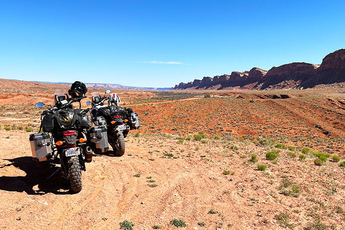
Throughout the trip, we’d been battered by winds that were contributing to fire restrictions in Arizona and Utah. At this point, the wind was howling, with 50-mph gusts giving us a good sand blasting. After a quick stop in Bullfrog, we headed north on State Route 276 and then south on State Route 95 to Hite Crossing over the Colorado River.
We had violated our “never pass gas” top-off policy in Bullfrog, expecting to find a place to refuel in Fry Canyon. Given the time of year and possibly other reasons unknown, the gas pumps were closed in Fry, so we pushed on through some gorgeous country that might’ve been easier to appreciate if we weren’t worried about our dwindling fuel.
At one point, we pulled over to assess the situation. Craig had been smart enough to fill his reserve bottle, which he poured into his tank. My bike was still showing a couple bars of fuel left. I tip my cap to the Yamaha Ténéré 700. Even though my fuel gauge was blinking “empty” and both of us were expecting the pullover of shame, we made it all the way to Blanding. The Arch Canyon Inn was a welcome stop, but being informed that it’s a dry town put the “bland” in Blanding.
Travelers in a strange land. Parts of Utah felt like being on another planet.
Leaving Blanding and getting on the Utah BDR was like visiting another planet. The Butler and Comb washes, the Moki Dugway, and Valley of the Gods were some of our favorite parts of this trip. With all the distinct rock formations, it was a challenge to stay focused on the trail and not get distracted by the scenery. In most cases, one blown turn can mean disaster, but the rewards are more than worth the risks. Again, caution saved the day.
The southern terminus of the Utah BDR is in the town of Mexican Hat, which I assumed was named after a mountain resembling a sombrero. Turns out, it is a distinctive disc-shaped rock about 60 feet in diameter that’s perched atop a smaller base at the top of a mesa. I’ll always remember it as the site of my first involuntary dismount from the Yamaha during a charge up a softer-than-expected mound of sand.
At the southern terminus of the Utah BDR in Mexican Hat. Behind me is the town’s namesake rock and below me is softer-than-expected sand.
The area around Mexican Hat borders the northern section of the Navajo Nation into Monument Valley. This area is considered the sacred heart of Navajo country, and you can’t help but marvel at how iconic the straight-line stretch of road is as it leads into the horizon, framed with towering sandstone rock formations. Hiking in the park is highly restricted, with only one path that can be hiked without a guide. Monument Valley Trail Park had been previously closed after a movie crew was caught filming without a permit. It is now reopened at a reduced occupancy limit, but no motorcycles are permitted on the 17-mile loop due to deep sand dunes in the area.
Dispersed camping near Hatch, Utah.
Back in Arizona, we cruised paved highways to Flagstaff and then down into Sedona. Determined to camp at a lower (read: warmer) elevation, we found the Lo Lo Mai Springs Outdoor Resort. Lo lo mai is a Hopi Indian word that represents a greeting with many meanings, similar to the Hawaiian aloha. It also means “beautiful,” which the owners of Lo Lo Mai Springs say is where the resort’s name originated. The area borders spring-fed Oak Creek, which is a valuable and rare natural water source in this part of Arizona. The campground had some welcome amenities and was a lot warmer than the prior camping stop.
Monument Valley.
We spent our last day exploring some of the Arizona BDR tracks in the Coconino National Forest near Sedona and Flagstaff. With time running out, we finally hopped on State Route 87 and burned the final miles to Scottsdale, where the town was alive with nightlife.
Returning the bikes was bittersweet. Bob welcomed us back, relieved that the Ténérés had only a layer of dust and a bit less rubber on their tires after 1,591 on- and off-road miles. As we grabbed an Uber to the airport, I could not help but realize the vast additional riding world that adventure motorcycling opens up. Soon after getting home, I put one of my streetbikes up for sale, and an adventure bike could be in my future.
The seeds of this West Texas motorcycle ride were planted in December 2019 when my buddy Reed and I joined the EagleRider Club. Members pay monthly subscription fees for credits toward motorcycle rentals, which roll over month to month and offer significant discounts versus standalone rentals.
In addition to the discounts, being club members allows us to fly into a new area and rent motorcycles that are different from what we ride back home. We live in Connecticut, so flying into Dallas saved us a 3,200-mile roundtrip that would have taken several days on each end. Instead of grinding out miles just to get to Texas and back home, we spent that time leisurely exploring roads and sights.
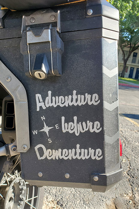
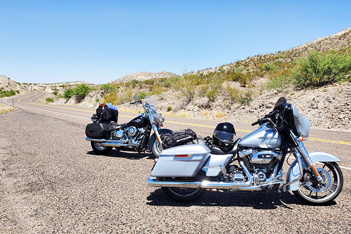
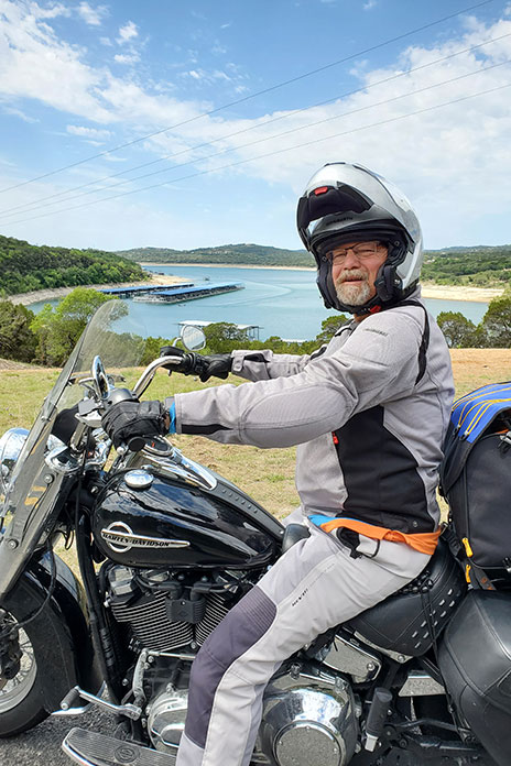
To beat the heat of the Texas summer, we planned our trip for mid-April. Reed and I are BMW riders, but for this trip we rented two late-model Harley-Davidsons: a Street Glide for me and a Heritage Softail Classic for him. There’s something special about riding the open road on a big American V-Twin. We’re older guys who were decked out in textile riding gear and modular helmets, so we’re hardly Easy Rider rebels. When we saw a BMW GS in a hotel parking lot with “Adventure Before Dementure” on one of its panniers, we could relate.
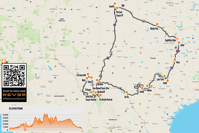
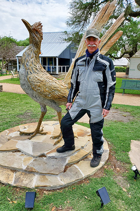
We did a clockwise loop of roughly 2,300 miles over nine days. From Dallas, we headed south to Texas’ funky state capital, Austin. The Harleys were stable and comfortable, the torque was intoxicating, and the horns were good and loud, but the transmissions were a bit clunky. After visiting the Texas Capitol, we rode east to Round Top, a small tourist town known for antiques. We were disappointed to find the antique markets closed when we got there, but I managed to get a photo with a roadrunner as tall as I am – things really are bigger in Texas!
West Texas is wide open.
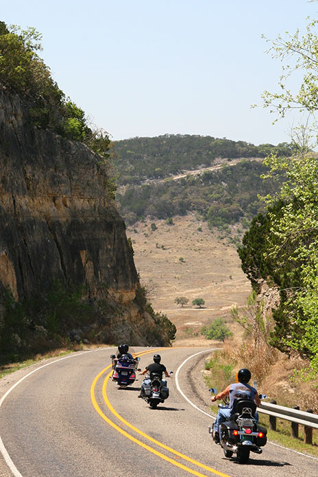
The riding improved west of Austin when we entered the legendary Texas Hill Country, an area well-known among motorcyclists. Endless hills turn the many rural FM (Farm-to-Market) and RM (Ranch-to-Market) roads into paved rollercoasters. We enjoyed nice twisties, light traffic, and pretty views along the shore of Lake Travis and through Inks Lake State Park. After riding through Llano, we dropped the sidestands and stretched our legs at Enchanted Rock State Natural Area. In Fredericksburg, a charming historic town surrounded by vineyards, we ate sausages and enjoyed live music during a courtyard dinner at a German restaurant.
Less than an hour from Fredericksburg and west of Medina, we rode the renowned Twisted Sisters. The three RM roads (335, 336, and 337) are full of fun curves and whoop-de-doos and are worthy of their reputation. The Twisted Sisters are so popular among motorcyclists that there are two-wheeled tourist stops in the area, like the Lone Star Motorcycle Museum in Vanderpool and the Frio Canyon Motorcycle Stop and The Hog Pen in Leakey. We passed many ranches; two of my favorite names were Big Bucks Ranch and Middle Age Spread.
Enjoying rolling curves through Texas Hill Country, home of the famous Twisted Sisters.
After a night in Del Rio, we followed U.S. Route 90 west along the southwestern border of the Texas Pecos Trail region and within a stone’s throw of the Rio Grande. Although our bikes had the same 107 engines, the Softail’s tank holds 5 gallons while the Street Glide’s holds 6 gallons. That 1-gallon difference became evident when we hit an 86-mile stretch with no services thinking we had enough gas. We were wrong.
Reed enjoyed riding his rented Harley-Davidson Heritage Classic.
Reducing speed and tucking in behind the windshield for the last 20 miles did the trick, but headwinds meant the Softail was running on fumes when we pulled into Sanderson. At the gas station, a lady with a ’50s-style bouffant told us that pickle juice is good for combating dehydration. We were intrigued, but we wondered if she was having fun at the expense of us Yankees.
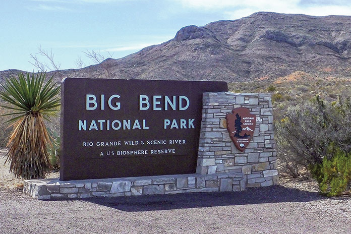
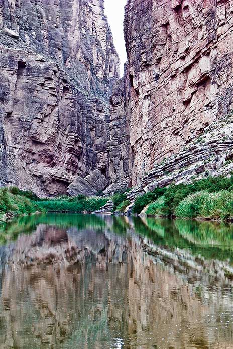
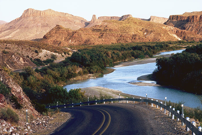
At Marathon, we turned south toward our next destination: Big Bend National Park. Situated in a pocket of West Texas where the Rio Grande’s southeasterly course makes a sharp bend to the north, Big Bend is enormous, covering more than 801,163 acres (1,252 square miles), making it the seventh largest national park outside of Alaska. In 1976, Big Bend was designated a UNESCO Biosphere Reserve. It contains the largest intact portion of the Chihuahuan Desert, one of the most biologically rich and diverse desert ecosystems in the world.
Located in West Texas where the Rio Grande turns sharply to the north, Big Bend National Park protects part of the Chihuahuan Desert.
Because Big Bend is far from major cities and the 118 miles of the Rio Grande along its southern boundary serves as the border between the U.S. and Mexico, it receives relatively few visitors compared to other national parks. That makes it the perfect destination for those who love wide-open spaces and don’t care for crowds.
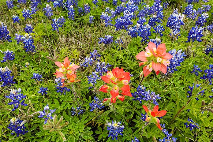
Wildflowers were blooming during our April ride.
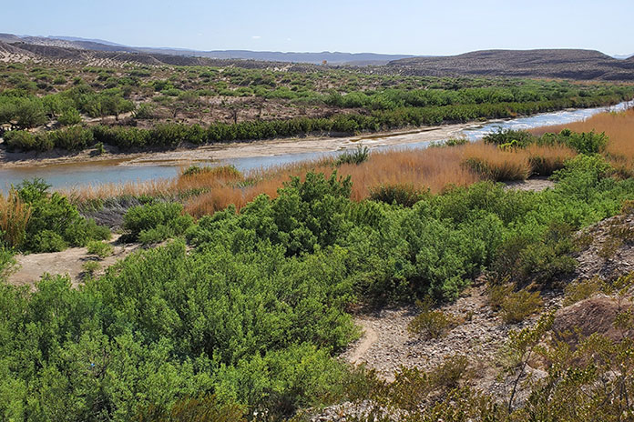
That afternoon we enjoyed Big Bend in all its glory. Mountain peaks topping 7,000 feet competed with colorful desert blooms for beautiful scenery. In Rio Grande Village, we learned of a tramway system that transported lead and silver from Mexico across the Rio Grande to eventually connect with the railroad in Marathon. For migrants, crossing the Rio Grande would have been a matter of simply wading the low waters, but passing the Border Patrol checkpoint some miles inland (in open desert) is another story.
The U.S.-Mexico border.
Highlights of Big Bend National Park include the winding road up to Chisos Basin, the Rio Grande Overlook, and Ross Maxwell Scenic Drive, which passes through Tuff Canyon on its way to Santa Elena Canyon Overlook. Of the 304 miles of roads in the park, 123 miles are paved, 45 miles are unpaved but improved, and 136 miles are unpaved and primitive, so there are plenty of miles to explore regardless of your preferred surface – or bike. That said, at our hotel in Alpine, located about 80 miles north of the park via State Route 118, another guest recounted how two Honda Africa Twins struggled in Big Bend’s sandy unpaved tracks, going down so often they gave up and had their bikes towed out.
The Rio Grande’s Santa Elena Canyon.
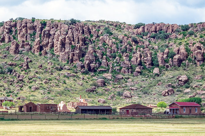
After spending the morning at Fort Davis, a national historic site north of Alpine with a well-preserved complex of buildings and visitor center, we embarked on our most challenging ride of the trip. We headed south on State Route 17 to Marfa and then took U.S. Route 67 to Presidio. From there, we rode east on FM 170, known as River Road. The 64 miles to Study Butte-Terlingua wind along the Rio Grande through Big Bend Ranch State Park. Except for the low water crossings, the road surface is generally good – and the views are fantastic – but riders need to stay frosty because there are sudden elevation changes, decreasing radius and off-camber blind curves, and sometimes wildlife on the road.
Fort Davis was a frontier military post from 1854-1891.
After getting our fill of mountains, canyons, rivers, and memorable Rio Grande scenery, we headed north through empty high desert to Fort Stockton, Odessa, Midland, and Lubbock, an area of Texas notable for the Permian Basin, an 86,000-square-mile area that’s home to some of the nation’s largest oil reserves. We rode for hours with oil wells scattered across the landscape in every direction. To our surprise, we also saw dozens of large wind turbines towering above some of the oil rigs, so some Texans are clearly hedging their bets.
Just south of Amarillo, we visited Palo Duro Canyon State Park, where we took in expansive views of America’s second largest canyon, which is 120 miles long, an average of 6 miles wide, and up to 1,000 feet deep. The sprawling canyon was the subject of paintings by Georgia O’Keefe, who lived nearby, and the site of a battle between Texas Rangers and Chief Kicking Wolf in Larry McMurtry’s novel Comanche Moon.
Located near Amarillo, Palo Duro Canyon is the second largest canyon in America.
Having completed much of our loop, we headed southeast toward Dallas. We took secondary roads through towns such as Turkey and Matador, the latter being the home of Bob’s Oil Well, a vestige of the days when bold roadside architecture attracted customers – in this case a wooden oil derrick towering above a gas station.
Everything is bigger in Texas. Words to live by.
The skies darkened as we rode east, and in Crowell, a lady pulled over to tell us there were tornados touching down near our next waypoint in Vernon. When an EMT reiterated the warning, we stayed put until the coast was clear. When we finally hit the road again that evening, it was a wet ride, but there was so much lightning arcing across the clouds in the distance that we had plenty of light to guide us. When we checked into our hotel in Wichita Falls, we learned they’d had heavy rain, wind, and golf ball-sized hail – one guest had a broken windshield to prove it.
FM 170, known as River Road, winds its way along the northern side of the Rio Grande between Presidio and Terlingua and forms the southern boundary of Big Bend Ranch State Park.
On our last day, we blasted along state highways to Dallas, and for long stretches, we enjoyed explosions of color from roadside wildflowers. Bluebonnet and Indian paintbrush were abundant, and mid-April was the perfect time to see them. We know better than to mess with Texas, but we sure do appreciate all the wonderful roads, sights, and beauty we experienced in the Lone Star State. And thanks, EagleRider, for renting us the Harleys – they were the perfect steeds for our journey.
On Day 1, riding the “Goat Road” (A-4050) through Sierras de Tejeda, Almijara y Alhama Natural Park on our way to Granada.
Every international motorcycle tour is special, but none is as memorable as your first one. For my wife, Carrie, and me, our first international tour was in 2010 – a two-week tour of Spain and Portugal with IMTBike, a motorcycle tour and rental company based in Spain with office locations in Madrid, Barcelona, Bilbao, Málaga, and Lisbon, Portugal.
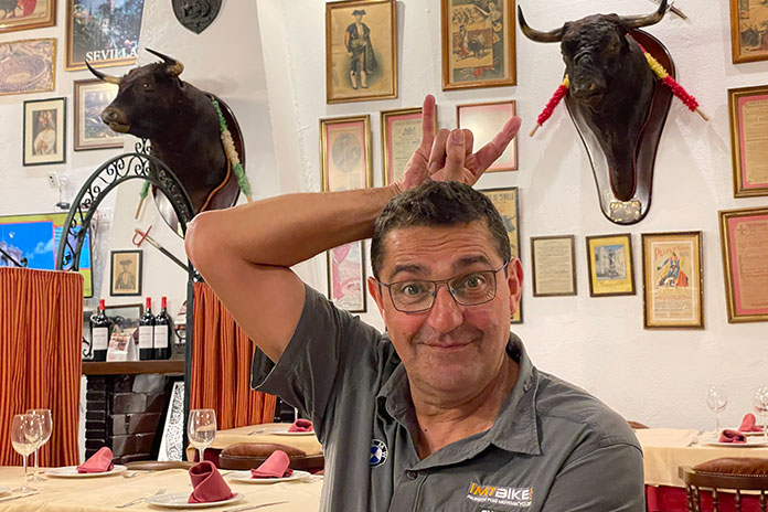
Carrie and I have had the good fortune to go on many international motorcycle tours together. Riding two-up, mostly on a big BMW GS, we’ve explored a dozen countries in Europe, as well as Canada and Ecuador. We got engaged at the top of Stelvio Pass in the Alps and spent our honeymoon on a tour in Norway. But for that first tour, our guides were Scott Moreno, IMTBike’s founder and CEO, and “Super” Chano Lorenzo, IMTBike’s longest serving guide, who’s been with the company since 1998.
Like old friends, Scott and Chano shared their unabashed love and deep knowledge of Spain and Portugal with everyone in our group, treating each one of us as special and taking time to get to know us so they could tailor the tour experience to our particular needs or desires.
Chano is part toro.
Wake-Up Call
Of all the tours Carrie and I have been on, our most embarrassing moment happened on Day 1 of that first tour in 2010 – before we had even gotten on the bike. While enjoying ourselves at the festive welcome dinner the night before, we imbibed a bit too much vino tinto. When we got back to the hotel, feeling the effects of jetlag and the wine, we decided to wake up early to pack and get ready for the tour. I set my alarm, and we went to bed.
With the curtains drawn to block out the city lights of Madrid, I was jolted awake by the phone. It was Chano. “Buenos dias, Greg! It’s nine o’ clock, and everyone is on the bus, waiting to go. Are you ready?”
Mierda! I had gotten the a.m./p.m. mixed up on my phone’s alarm.
“I’m soooooo sorry! We overslept!”
“Don’t worry, that means you were relaxed! Scott will head over on the bus with the others and start the bike handover. I’m downstairs with everyone’s luggage in the van. I’ll wait for you.”
Hungover with throbbing headaches, our pulses racing, we threw everything into our luggage and suited up in our riding gear as fast as we could. Carrie and I are both fastidious Type A people, and we hate being late. We did the walk of shame out to the van, only to find Chano with a big smile on his face as he reassured us, “Is no problem!”
And it wasn’t. As embarrassed as we were, Chano and Scott just rolled with the situation. Our blunder was the source of playful ribbing throughout the tour, an inside joke we still share to this day. And we learned our lesson – in nearly 100 days we’ve spent on overseas motorcycle tours since that first morning, we have not been late once, and we’re often the first people on the bikes in the morning, ready to go.
A Very Good Year
The rolling hills in the Andalusia region are covered with millions of olive trees. (Photo by Carrie Drevenstedt)
Like all motorcycle tour companies, the pandemic was a gut punch to IMTBike. Covid restrictions meant the company couldn’t run tours for more than a year, but Moreno kept his team on the payroll, and they used the downtime to refresh, refine, and expand their tour offerings. IMTBike specializes in tours of the Iberian Peninsula (Spain and Portugal), but it also offers tours in France, Italy, the Alps, and Morocco, as well as MotoGP tours (Catalunya, Jerez, and Valencia) and tours in Turkey, Thailand, Japan, and New Zealand.
IMTBike resumed its tours in 2021, the same year it earned a coveted Tripadvisor Travelers’ Choice Best of the Best award. In 2022, IMTBike celebrated its 25th anniversary, and Scott personally invited Carrie and me to join him and Chano on the Southern Spain Andalusia tour.
As much as we were looking forward to getting the band back together for a reunion tour, a family emergency precluded Scott from joining us. Chano served as head guide, and our consolation prize was Paolo Pezzoli, a young, energetic Italian who was new to the IMTBike team.
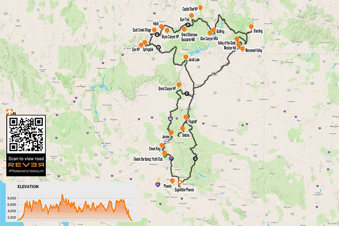
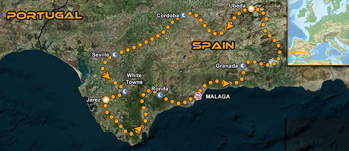
The Southern Spain Andalusia tour hits the sweet spot – not too short or too long, not too easy or too challenging, and just right in terms of daily mileage, choice of roads, scenery, sightseeing, and accommodations. The tour is nine days, with six riding days, one rest day, and travel days on each end. It starts and ends in Málaga, a city on Spain’s Mediterranean Costa Del Sol (Sun Coast), and includes stops in Granada, Córdoba, Seville (rest day), Arcos de la Frontera, and Ronda.
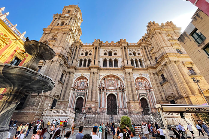
Carrie and I arrived a day early to shake off our jetlag and spend a day exploring Málaga, which was founded in 770 B.C. and is one of the oldest continuously inhabited cities in the world. IMTBike booked a modern, stylish hotel that’s a short walk to the heart of the city. We visited the 19th-century Atarazanas Market, the 14th-century Cathedral of Málaga, and the 11th-century Alcazaba, a Moorish palatial fortress perched on a hill overlooking the city and coast.
The Renaissance-style Cathedral of Málaga was built between 1528 and 1782 but is technically unfinished since the tower on the right is incomplete.
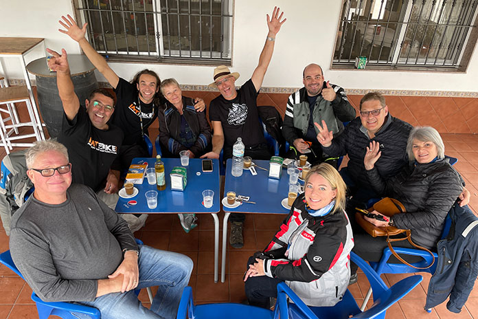
After our walking tour – which included a stop at a busy sidewalk cafe for tapas, sangria, and people-watching – we met the tour group in the hotel’s bar. Over beers and wine, we met Lonny and Linda, a couple from Idaho; Kobus and Magda, a couple from South Africa; Bernard, a solo rider from Canada; and Oliver, a solo rider from Dominican Republic. Each of us took turns telling the group a little about ourselves, and Chano gave us an overview of the tour and rules of the road in Spain.
To keep us connected, IMTBike set up a group on WhatsApp so we could send text messages, live locations, photos, and more via Wi-Fi. We also received links to the tour’s daily routes on Google Maps and to a Google Drive folder so we could upload and share our photos.
Following the briefing, we walked to dinner. Spain is known for its afternoon siestas and late-night dinners, and in the evenings, the streets of cities we visited were bustling with locals and tourists, young and old and everything in between. Our tour was in October, with mild days and cool nights – ideal for strolling on cobblestoned and tiled sidewalks that are hundreds of years old, their surfaces worn smooth by millions of footsteps. Our welcome dinner was at a restaurant handpicked by IMTBike, and Chano got us started by ordering Iberian ham, cheese, and wine for the table. Everyone was in good spirits as we broke bread and got to know each other.
Up, Up, and Away
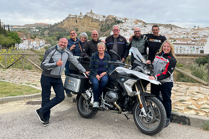
Our crew (plus Paolo behind the lens) enjoying a short break overlooking Arcos de la Frontera. We stayed in a historic Parador situated on the edge of the cliff in the background. (Photo by Paolo Pezzoli)
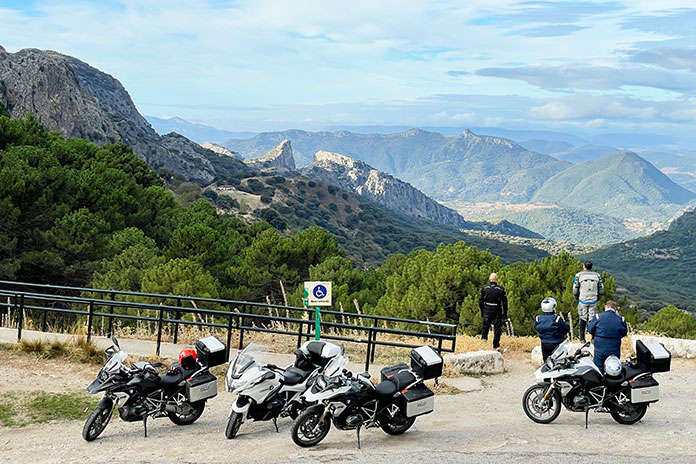
Carrie and I woke up early, enjoyed a decadent breakfast at the hotel, brought our luggage down, and walked outside to find two R 1250 RTs, three R 1250 GSs, and an F 850 GS lined up on the sidewalk. IMTBike is an official partner of BMW Motorrad, and it owns the world’s largest fleet of BMW motorcycles (more than 200 at last count). Bikes available to rent range from the G 310 R to the K 1600 GT, and all are outfitted with a top case and side cases; a GPS unit is optional. Our group was followed by a support van that carried luggage and a spare bike.
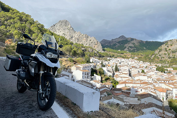
Grazalema is one of the many Pueblos Blancos (White Towns) tucked into the mountains of Andalusia.
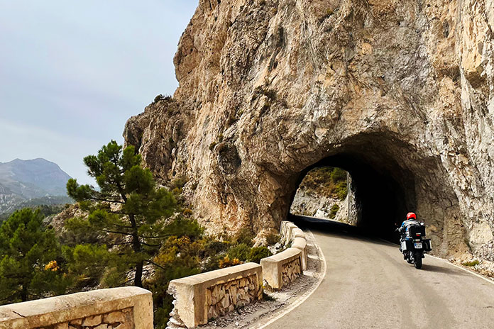
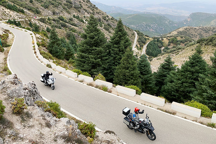
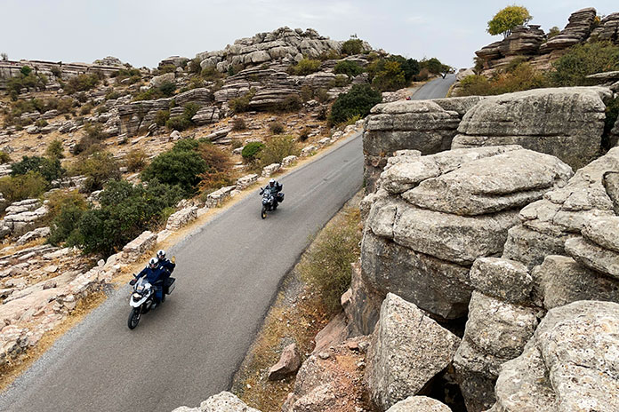
On our first tour in 2010, Carrie and I described Spain as “California with castles.” The coastal areas of Southern Spain and Southern California have mild Mediterranean climates as well as rugged mountains that rise dramatically from the sea. Within minutes of leaving Málaga, we climbed up, up, up into the mountains on a tight, steep, endlessly curving road that kept us on our toes. After a midmorning coffee stop, we rode back down to the coast to have delicious paella right next to the beach. We ascended into the mountains again on a narrow lane carved into the rock known as the “Goat Road,” arriving in Granada in time to explore the city’s old quarter before meeting up for a gourmet dinner at one of the best restaurants in the city.
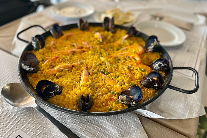
Paella, made with rice, saffron, seafood, and chicken, is one of Spain’s most emblematic dishes.
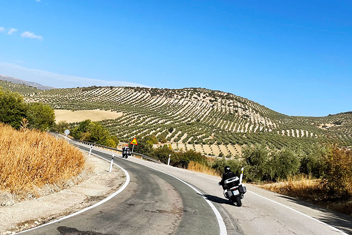
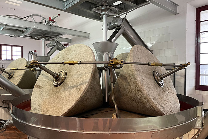
From Granada, we got full use of our tires and leaned deeply through the curves of a shaded canyon before popping out into the high plains, where we got a bird’s eye view of the village of La Peza from an overlook. We rode through endless olive groves and visited the Núñez de Prado organic olive oil factory in Baena, where the olives are crushed by enormous stone mills to extract the “flower” and first cold pressing of extra virgin olive oil.
Large cone-shaped stones are used to crush olives at the Núñez de Prado olive oil factory in Baena.
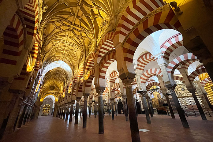
After lunch in the Baena town square, we rode to Córdoba, home to more UNESCO World Heritage Sites than any other city. It was a hot afternoon, so we cooled off in the rooftop pool overlooking the Guadalquivir River and the city. We explored the narrow, cobblestoned streets and visited the stunning Mosque-Cathedral of Córdoba. At an outdoor cafe, Carrie and I joined Lonny and Linda for sangria, and then we enjoyed a family-style dinner with the group at a local restaurant.
Inside the incomparable Mosque-Cathedral of Córdoba, a UNESCO World Heritage Site that blends Moorish and Renaissance architectural styles.
On our third day, we rode from Córdoba to Seville on a series of backroads that seemed tailor-made for motorcyclists. Spain is a motorcycle-mad country, and you can’t help but think that civil engineers said to themselves, “Let’s make these curves flow with a nice rhythm. We’ll give them a consistent radius, good banking, and smooth pavement. Riders will love it!”
After winding through farmland with rolling hills filled with oak and cork trees, herds of sheep, and black Iberian pigs (the source of highly prized jamón pata negra), we rode over the Sierra Morena mountains and back down into the Guadalquivir River valley and the magnificent city of Seville.
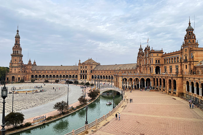
Plaza de España in Seville.
We arrived with a few hours to unwind, relax, and explore before dinner. We walked from the hotel to an old restaurant decorated with bullfighting memorabilia, and we enjoyed vino tinto and plates of jamón, queso, ensalada mixta, and other delicacies, all topped off with a variety of diet-busting sweets and little glasses of house-made liqueur.
Caves, Coffee, and Cava … IMTBike Style
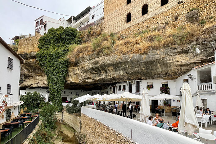
After a rest day exploring the wonderful city of Seville and a mesmerizing flamenco show, we continued our meandering lap around Andalusia. We rode through rolling hills of olive trees and passed several of the region’s iconic Pueblos Blancos (White Towns), where all the houses and buildings have whitewashed walls and terra cotta tile roofs. We stopped for lunch in Setenil de las Bodegas, a town built along a small canyon with houses and shops built into the hollowed out limestone caves on both sides of the river.
Houses and shops in Setenil de las Bodegas are built into limestone caves along the river.
Next up was the most impressive road of the trip, an Alps-like climb from the valley to 4,452-foot Palomas Pass. We descended an equally winding and scenic road and made our way to Arcos de la Frontera, an old town built high on a limestone promontory. De la Frontera means “on the frontier,” so named because Arcos was on the frontlines of Spain’s 13th-century battle with the Moors. Perched on the edge of the cliff overlooking the Guadalete River, our hotel was a Parador, one of roughly 100 hotels managed by Spain that are in buildings of historical, artistic, or cultural interest.
The winding road up to Palomas Pass reminded us of the Alps.
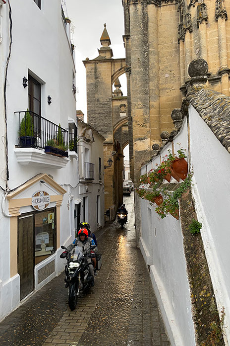
Leaving Arcos de la Frontera, we rode under the flying buttresses of the cathedral and descended steep, narrow cobblestone streets made damp by overnight rains. We continued our ride along La Ruta de los Pueblos Blancos (Route of the White Towns) where whitewashed villages on the mountainsides stand out like large polka dots on the green landscape. We rode into Sierra de Grazalema Natural Park and wound our way up to El Boyar Pass on our way to our morning coffee stop in a bustling town square.
In Arcos de la Frontera, we stayed in a Parador across from the 15th-century Basílica de Santa María de la Asunción. Its flying buttresses tower over the narrow road that leads into the town’s old quarter.
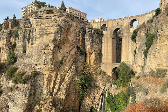
Every day, we rode up and down on small mountain roads and through idyllic agricultural plains. Traffic was minimal, and the rugged, old-world scenery was enchanting. On our fifth riding day, we enjoyed more fast and fun roads in the afternoon as we made our way to Ronda, a city perched high on both sides of the Tajo gorge carved by the Guadelevin River. We stayed in a Parador on the edge of a cliff overlooking the “new” 300-year-old bridge over the gorge (the old bridge was built during the Roman Empire).
Our second clifftop Parador of the tour was in Ronda, overlooking the “new” bridge and the Tajo gorge.
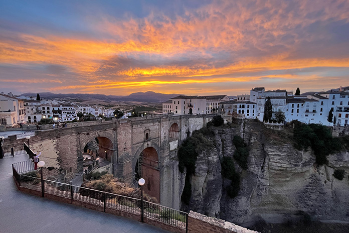
We started our last day of the tour with a beautiful sunrise over Ronda. We rode east into the rugged granite mountains of Sierra de las Nieves Natural Park, winding our way through canyons and over passes toward El Burgo.
Sunrise over Ronda.
It was Saturday, and we stopped for coffee at a popular meet-up spot for motorcyclists, its tables abuzz with riders and its parking lot full of bikes. The final highlight of the tour was a ride up to El Torcal de Antequera, a mountain ridge covered in unusual karst rock formations that reminded us of Joshua Tree National Park seen through the eyes of surrealist painter Salvador Dalí.
Having fun during a coffee stop.
We descended more narrow, twisty roads back to Málaga, where we turned in our BMWs at IMTBike’s warehouse and toasted a celebratory glass of cava. After drinks and laughs on the hotel’s patio, we enjoyed a festive farewell dinner at another wonderful restaurant.
Admiring the view from El Boyar Pass in Sierra de Grazalema Natural Park. The Mediterranean Sea is visible on a clear day.
The week went by fast, a sure sign of how much fun we had. Chano and Paolo were a constant source of charm and good humor, and they did a lot of work behind the scenes to keep everything running smoothly. Our small group bonded quickly, and even months after the tour, we still send messages via WhatsApp to stay in touch.
Lonny and Linda, a delightful couple from Idaho, enjoy a scenic ride through Sierra de Grazalema Natural Park.
If you love good roads, good food and wine, and nice accommodations, as well as history, architecture, and rugged mountain scenery, this tour is for you. Just try not to oversleep.
On the last day of the tour, we rode through El Torcal de Antequera, a natural reserve that protects a mountaintop covered in unusual rock formations.
The 2023 Southern Spain Andalusia tours run March 11-19, April 15-23, and Oct. 14-22. Visit the IMTBike website for more info.
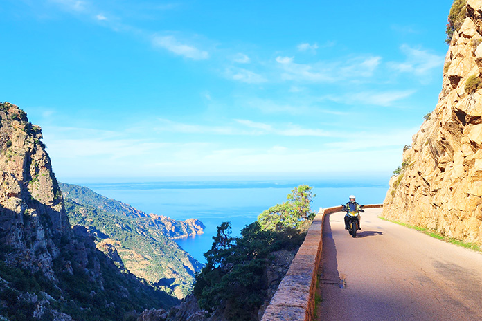
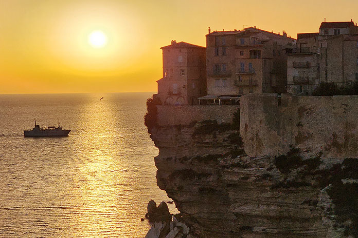
This winding road hugs the sides of colorful peaks rising from the sea at Calanques de Piana, Corsica.
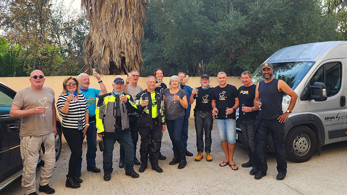
The Sardinia & Corsica – Riders’ Heaven tour was my first guided motorcycle tour. It won’t be my last. For nine days in mid-October, I rode with 10 experienced riders from six countries on intensely winding roads through spectacular scenery. We toured the Mediterranean islands of Sardinia (an autonomous region of Italy) and Corsica (an autonomous region of France). Adriatic Moto Tours made it easy: Just show up with your gear and ride.
Adriatic Moto Tours Riders’ Heaven Day 1: Olbia, Sardinia
After exploring Olbia’s old town on foot, I returned to the hotel to find 10 motorcycles lined up like soldiers awaiting inspection. I recognized a smiling face from the Adriatic Moto Tours website and said hello to Anže Colja, our guide for the Sardinia & Corsica – Riders’ Heaven tour. Six riders in our group had taken an AMT tour before, and one was taking his fifth.
Later, at the introductory briefing, Anže offered insights about riding these Mediterranean islands. “The roads are fantastic,” he said, “the best in Europe. Every day we will ride narrow, twisty, technical roads, but you’re not on a racetrack, you’re on vacation. Can you see far enough to pass? Wait until it’s safe, then commit and go! Take care of each other, and have fun.”
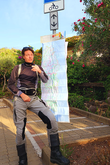
Each morning, Anže briefed us on the day’s ride.
Born and raised in Ljubljana, the capital of Slovenia, Anže is an economist by training and an affable soul by nature. He speaks Slovenian, English, German, and Croatian, plus enough Italian and French to help us order meals in restaurants that cater to locals rather than tourists. And, as we discovered, he’s one talented rider.
Anže explained that our group would stay united, though not always together, using the system of Static Corner Marking. Anže would always lead, one rider would bring up the rear, and riders in between would alternate “marking” where the route turns by remaining at the junction until the next rider arrives. Each rider also had a GPS with daily routes pre-programmed, so it was hard to get lost. And if we wanted to go on our own, we simply let Anže know.
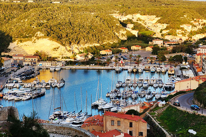
The coasts of the Mediterranean islands of Sardinia and Corsica are dotted with small ports and harbors full of fishing boats, sailboats, and yachts.
We also met Peter Cvelbar, who drove the support van and managed tour logistics. Peter is a staff sergeant in the Slovenian Army, and he used a portion of his leave to work this tour. Each morning, we found our bikes wiped down and positioned for a smooth departure, but he did much more. Our luggage was waiting for us in each new hotel room. Bike or equipment issues were quickly addressed. We were given information regarding travel, food, and culture. Both disciplined and easygoing, Peter worked his magic behind the scenes so all we needed to do was ride.
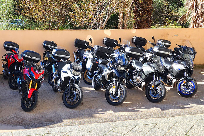
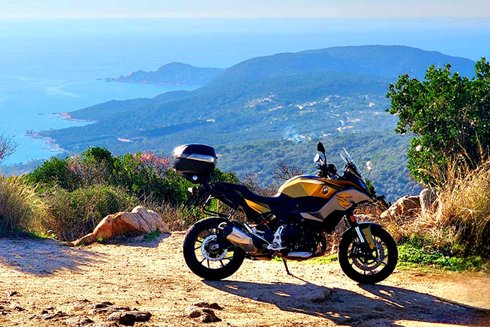
After being assigned bike keys, registration papers, and GPS units, we checked out our machines. I chose a BMW F 900 XR for its torquey twin-cylinder engine, flickable handling, and strong brakes. Its Galvanic Gold colorway certainly stood out too.
When we gathered for dinner, a guide’s principal value – local knowledge – was revealed. In Olbia’s old town, Anže led us off the main pedestrian way and along a succession of narrow cobblestone alleys, past a sign declaring “NO PIZZA,” and downstairs to an intimate restaurant. Staff were expecting us, and our table was waiting. After dessert, we returned to the hotel and traded stories on the portico, eagerly anticipating the next day’s ride. (Breakfast and dinner are included on this tour. Riders pay for their lunch, alcoholic drinks, and fuel.)
Adriatic Moto Tours Riders’ Heaven Day 2: Olbia – Ajaccio
Our first day riding took us north along the famous Costa Smeralda (Emerald Coast) and past the granite and basalt rock formations that form the two islands. The route was scenic and curvy, but Anže said we hadn’t seen anything yet.
In Santa Teresa, we caught a ferry to Bonifacio, Corsica, a historic city on a cliff, and then rode north toward Ajaccio, birthplace of Napoleon Bonaparte and the capital of Corsica. The roads to Ajaccio became tight and technical, with curves that just kept coming.
Along the coastal road in Coti-Chiavari, I spied an unpaved lay-by with a stellar view, so I pulled over. While shooting photos, I walked up to the highest rocky point. A man was sitting there, seemingly alone with his thoughts, but he gestured for me to join him. “Parlez-vous anglaise?” I asked, hoping he spoke English. He shook his head. “Non.” So instead of talking, we shared the dramatic vista in silence. After a while I said, “Au revoir,” and we shook hands genuinely, cementing a friendship of coincidence.
At dinner in Ajaccio, Anže asked the group which of the next day’s two route options we preferred. I was leaning toward the longer option (more riding), but he suggested the shorter option through the sparsely populated interior. “Less traffic,” Anže assured me. “And twistier.” Local knowledge proved its worth once again.
In Coti-Chiavari, Corsica, I shared a spectacular view of the Mediterranean with this coincidental friend.
Adriatic Moto Tours Riders’ Heaven Day 3: Ajaccio – Corte
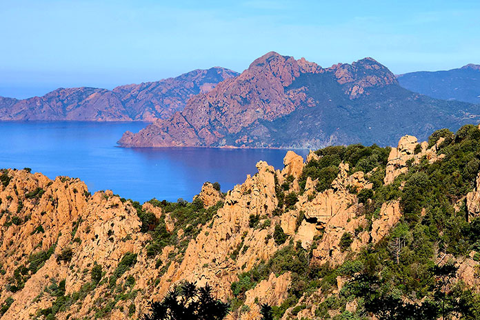
Corsica has more mountains and rivers than any Mediterranean island, and the roads hug the constantly changing landscape. After a mid-morning break for coffee, we rode to the Calanques de Piana, spiky granite formations that rise from the sea in shades of red, brown, and orange. The road is carved into their sides. Places to stop and safely enjoy the view are few, but Anže knew just the spot. I set up a group photo against a red rock backdrop; that one’s going in a frame.
Stone peaks in shades of red, brown, and orange jut from the sea at Calanques de Piana, Corsica. The island is an autonomous region of France.
Next, we turned inland for the mountain route. Flat land is rare on Corsica, so it’s common to see cows grazing along the road. They seemed accustomed to motorcycles passing by, but we slowed down and gave them space. I had to wait as two cows crossed a one-lane bridge at a leisurely cow pace. We also encountered large pigs foraging in the road on fallen chestnuts. Later, Anže explained that Napoleon had planted chestnut trees along roads in lands he controlled to provide his troops with shade and a source of food. The pigs appreciated that too.
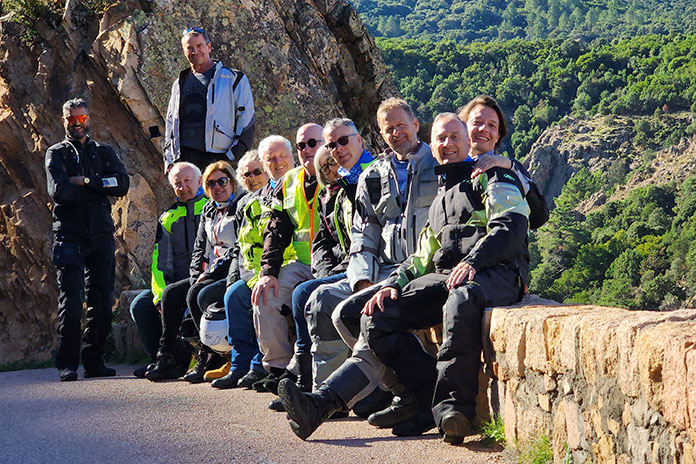
Happy riders from six countries mug for the camera at Calanques de Piana, Corsica.
We continued curving and gaining elevation. Our hotel in Corte overlooked the rugged landscape we rode through. The view from my room was stunning. For dinner, I chose local pork (chestnut fed?) roasted for six hours and served with cannellini beans. It was succulent – definitely not your mom’s pork-and-beans.
Adriatic Moto Tours Riders’ Heaven Day 4: Corte – Bonifacio
Anže mentioned at our first rider briefing that he’s an instructor at a high performance riding school. I rode behind him as we ascended mountains through one hairpin turn after another. I noticed he was looking back at me in his mirrors – always the instructor.
We built a fair distance between us and the next rider, so Anže pulled into a lay-by to regroup. While we waited, I asked how I was doing through the hairpins and what I could do better. He suggested looking even deeper into corners and modulating speed in turns using the rear brake instead of rolling off. On these roads, I practiced this technique over and over. When our group stopped in Cozzano, Anže and I continued the lesson over coffee.
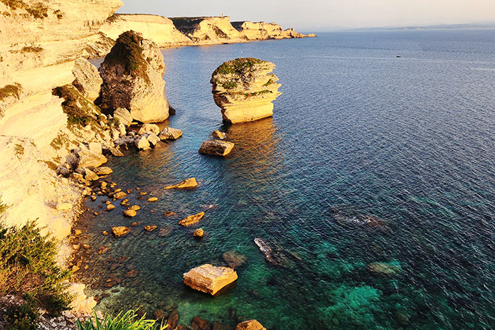
That evening, we caught a dazzling sunset from the limestone cliffs at Bouches de Bonifacio, a nature reserve. After some free time exploring the narrow, cobbled alleys of Bonifacio’s old town, Anže led us to a small restaurant that caters to Corsicans.
Views from the cliffs at Bonifacio, Corsica, did not disappoint.
Adriatic Moto Tours Riders’ Heaven Day 5: Bonifacio – Alghero
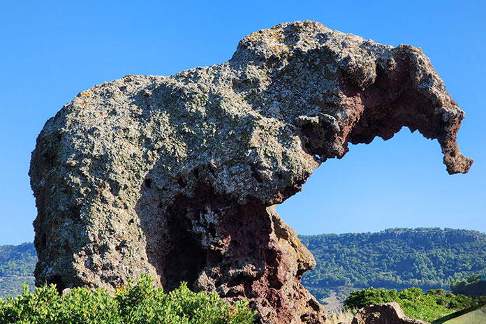
As we boarded the ferry that brought us there three days ago, we left behind the most intense, continuous twisties I’ve ever ridden. Anže assured me there would be more in Sardinia. Along the route in Località Multeddu, we visited Elephant Rock, which lives up to its name. Farther on, we stopped at the coastal town of Castelsardo, known for colorful homes built into the mountainside above the sea.
In Località Multeddu, Sardinia, Elephant Rock lives up to its name.
We savored more twisties and sparse traffic until we approached our destination of Alghero. In this historic and congested city, Static Corner Marking kept the group united. We all arrived safely at our hotel as the sun was setting over Rada di Alghero.
The Carlo V Hotel and Spa is rated five stars. It’s the fanciest hotel I’ve ever visited while riding a motorcycle. Throughout this tour, our accommodations exceeded my expectations. The dinners were impressive as well. Each evening, Anže ably selected starters for the table, then we all ordered a la carte from the menu.
At Castelsardo, Sardinia, colorful homes are built into the rocky hillside.
Adriatic Moto Tours Riders’ Heaven Day 6: Rest Day in Alghero
A day away from continuous, intense twisties afforded my mind and body a well-earned break. Fueled by a growing Italian vocabulary, a willingness to wander, and two scoops of mid-morning gelato, I explored the sprawling old town. After lunch, four of us enjoyed afternoon cocktails and a swim in the hotel pool, which wasn’t heated – brrrr!
We spent our rest day in Alghero on Sardinia’s western coast.
When my stomach signaled it was ready for dinner, I searched for cucina tipica Sarda (typical Sardinian cuisine) and chose pescata de giorno (catch of the day). The server took me to select the specific fish the chef would prepare for me. “You like grilled with patatas and pomodori, signore?” Sì, grazie. The chef served my dish tableside, and everything was delicious. A lemony concoction arrived for dessert, then I ordered a dram of 16-year-old scotch to complete the experience. Walking back to our hotel, I ran into tour members dining al fresco on the seaside promenade. We all had a good day off.
Refreshed and ready, we followed Anže along the winding coastal road south to Bosa. As we rolled through town, a smiling old woman stood on her stoop and waved to us. I blew her a kiss in return, and by the look of her reaction, I suspected it made her day.
Everyone enjoyed riding at their own pace, and we’d regroup at stops.
We kept twisting east on roads less traveled through Macomer and on to our first stop, the Nuraghe Losa of Abbasanta. It’s one of thousands of cyclopean stone monuments unique to Sardinia and built by a Bronze Age people called the Nuraghi between 1,600 BCE and 1,200 BCE. Anže arranged a private tour, and a delightful woman named Pina helped us appreciate the monuments and the people who built them.
Over lunch, Anže reminded us to embrace Sardinia’s offering to riders: roads with practically perfect grip and corners that seem to continue forever. AMT schedules the Riders’ Heaven tour twice a year: in spring (before tourist season begins) and in fall (after it’s over). That’s why these roads were largely ours.
Near Siniscola, Sardinia, this road curves along below the ridgeline.
For afternoon coffee, we stopped in Orgosolo, which has murals painted on buildings throughout the town. Most feature themes of social resistance, and many seem informed by the style of Picasso’s Guernica.
Next, we carved curves down the mountains to Cala Gonone. Our hotel was across the street from the Mediterranean Sea, and several of us enjoyed a swim before dinner. Thankfully, the water was warmer than the hotel pool in Alghero. After dinner and more conversation, I retired for the night to the sound of waves crashing ashore outside my window.
Rocky scenery surrounded us, such as here in Zérubia, Corsica.
After following closely behind Anže for several days, I volunteered to bring up the rear, which presented opportunities to enjoy scenery that wasn’t whooshing past in a blur. Beyond Lula, we gained elevation along a meandering road chiseled into the mountainside. Up to the east were bald peaks reaching skyward. Off to the west was a rolling valley of green forest interrupted occasionally by terraced farmland. A road was carved into the next distant mountain too, leading to a village perched on a rocky hillside. Farther west were multiple rows of rock-topped mountains fading into the horizon.
From Nuoro to Bitti, the roads zigged and zagged through cork plantations and over mountains. Eventually we reached Olbia and concluded this incredible journey at the same hotel where it started. Peter welcomed us with champagne, and we raised our glasses in celebration. What a trip it had been!
Bark has been harvested from this cork oak. The bark will grow back, making it a sustainable resource.
At our final dinner, Anže told me that Sardinia and Corsica are his favorite places to ride, without question. “Not for the sights or food, which are still good, but for the roads, which are insanely good. The grip is great, the curves have positive camber, and you just keep twisting through mountains, forests, and coastlines. And off-season, when the crowds are gone, you can just go.”
AMT’s Riders’ Heaven tour was a fantastic experience for me at every level: bike, roads, routes, scenery, sights, cities, towns, people, food, accommodations, leadership, logistics – the whole package. And leveraging a guide’s local knowledge brings it all together.
A champagne toast marks the end of the Riders’ Heaven tour. Salute!
In 2023, the Sardinia & Corsica – Riders’ Heaven tour runs May 13-21 and Oct. 14-22. Visit the Adriatic Moto Tours website for more information.
The roads in Nevada’s Valley of Fire State Park cut through some of the world’s most stunning red rock formations.
Johnny Cash sang about fire, murder, heartbreak, and sin, and I think he would have appreciated the symbolism of this ride, given its route. Northeast of Las Vegas is one of the most visually stunning state parks in the Southwest. The added bonus for motorcyclists is that the park’s roads trace through the crimson landscape like slithering black mambas. A ride through Valley of Fire State Park and Lake Mead National Recreation Area makes for a fantastic motorized respite from the neon bustle of Vegas.
The Las Vegas Strip, with its massive themed casinos, sidewalk solicitations, and congestion, is not my cup of tea. That’s why my staging point for this ride was Fremont Street. While still over-the-top, this area has the feel of an older, more genuine version of Vegas.
The night before my ride, I watched a cover band play classic rock tunes under the lights and video canopy that spans Fremont and enjoyed a variety of street performers. The next day, I put a couple bottles of water and lunch in the saddlebags of my BMW R 1200 GS and mounted up.
Fremont Street is well north of the traffic and congestion of the Strip, so getting out of the city was much more convenient than it would have been if I had opted for lodging at one of the mega-casinos. On my way out of town, I rode past the Mob Museum and the Neon Museum – Vegas-themed tributes that were added to my post-ride entertainment schedule.
The Las Vegas Wash runs as a tributary to Lake Mead, adding yet another unique visual element to this great ride.
The cruise northeast on the Las Vegas Freeway (Interstate 15) was a nice warm-up to this loop ride. The muted hues and desert views were expansive as I climbed out of the neon valley. There were a few floating cotton balls in the otherwise intense blue of the mid-morning Nevada sky. The line where the horizon meets the sky was as crisp and sharp as I have ever seen.
After 30 miles of motoring on the freeway, I diverted the GS eastward onto the Valley of Fire Highway. The two-lane tarmac starts as a gently curving and undulating climb into the gray stone mountains that were part of the striking delineation I enjoyed just miles before. However, the monochromatic gray soon gives way to vibrant blotches of crimson. Contemplating the name of the Valley of Fire State Park, I couldn’t help but imagine those red spots as flare-ups caused by the wind-carried embers of an approaching wildfire.
The various hues of the desert landscape in the Valley of Fire make for a ride with an almost cinematic feel.
My first stop in the park was at the aptly named Beehives. There is little doubt what all the buzz is about. Cringe-worthy puns aside, the Beehives are a spectacular object lesson on the artistic creativity of erosion. The hives are stratified tributes to the power of wind, water, and time.
The Beehives are whimsical sentinels that add to the region’s other-worldly feel.
By the time I got to the turnoff for the park’s visitor center, I was fully engulfed in the figurative flames of the Valley of Fire. I live near Sedona, Arizona, and I have ridden extensively through the red rocks of southern Utah, so I have a solid base of reference for the hue of red sandstone. Valley of Fire is something different. The terrain carries a deeper, more blood-like patina in this region. It is stunning.
The smooth and well-maintained winding roads through the Valley of Fire are tailor-made for motorcycling.
I bought a $10 park pass at a self-serve kiosk and rode up Mouse’s Tank Road. The endgame of this beautiful ride was a short hike on The White Domes Trail, where I enjoyed a drink of water and a snack and took in the majesty.
I am not usually a fan of out-and-back routes; however, this ride, carving through the curvaceous rock formations of the park, is fantastic in both directions. It’s only about 6 miles from the visitor center to the end of Mouse’s Tank Road, so the ride through the heart of the park is short but very scenic.
The mix of elevation changes and a smorgasbord of turns makes the ride through the Valley of Fire very entertaining.
Back on the Valley of Fire Highway, I was awed at the beauty around me. The road follows the undulations and sinews of the red rocks. I made a final stop at Elephant Rock and meandered up the trail in my Sidi boots. It was well worth the wear on the soles of those expensive kicks. Elephant Rock is yet another of the park’s formations that is stunningly indicative of nature’s wonders.
If this were a full daytrip rather than a through-ride, I would have stopped and hiked several more of the park’s features, like Arch Rock and Atlatl Rock with its Native American petroglyphs. The park is deserving of more exploration than I was able to give it.
A fellow biker gives the universal salute as he rolls through Lake Mead National Recreation Area.
Back on the BMW, I made my way to the end of the park’s highway at its intersection with North Shore Road (State Route 167). The referenced shore is the bank of Lake Mead. The “shore road” moniker is a bit of a misnomer. The Southwest’s unprecedented drought has drawn the reservoir down to a record low, so I was quite some distance from the lake. While not a waterside trek, the ride in the Lake Mead National Recreation Area is entertaining and beautiful. I was back in that fringe environment where red outcroppings dot the gray landscape. The fire was to my back this time.
The terrain within Lake Mead National Recreation Area is stark, barren, and beautiful.
Farther west on my return toward Vegas, the flatter, muted desert landscape returned. Cactus, desert brush, and the occasional dwarf palm dotted the horizon, and the final leg was relaxing as I traveled back from the Valley of Fire to the valley of neon. With proper gear choices, this is a ride that can be made virtually year-round, and I will certainly be back. From the City of Sin to the Valley of Fire, it’s a heavenly ride indeed. The Man in Black would approve.