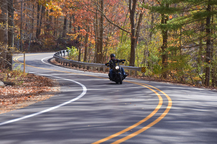
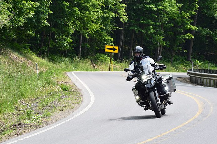
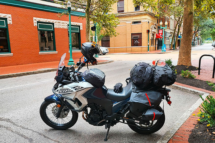
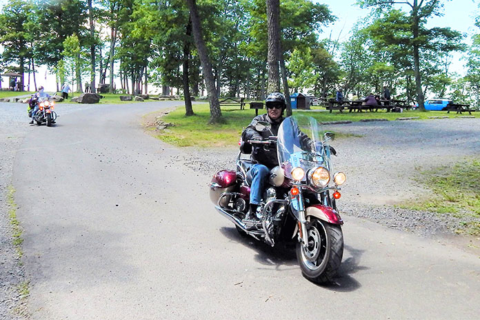
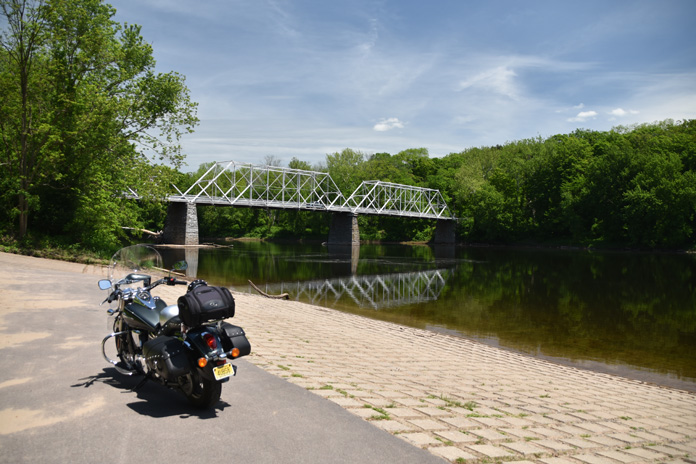
Rumbling through a kaleidoscope of woodland colors, a rider and his passenger on a New Jersey backroads motorcycle ride enjoy the curves of Clinton Road as it ambles through the Pequannock Watershed.
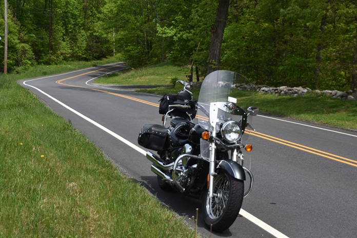
When the leaves tremble with their last days of color and the north winds begin to blow, I want to seize the day and take a ride before the snowflakes fly. I like to experience a variety of roads and sights all within the limited daylight of late fall. Northern New Jersey has great roads that ramble through state forests, around reservoirs and farms, and into small towns, making for a superb day ride.
I had plotted a route for this trip, but soon after my ride began, I saw a road sign that warned: APPLE SEASON HEAVY TRAFFIC. The last thing I wanted was to be stuck in the middle of a traffic jam surrounded by carloads of apple‑picking tourists slowly swarming toward orchards, so I threw out my itinerary and decided to go wherever the road and my gut told me.
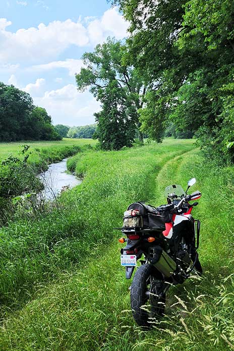
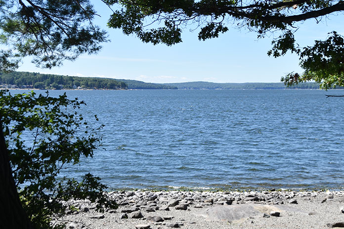
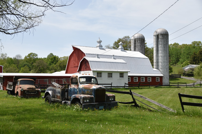
Rolling up Abram S. Hewitt State Forest’s Bearfort Ridge on the serpentine Warwick Turnpike, I avoided the congestion by taking the forest‑enveloped Clinton Road, which snakes through a large section of the 35,000‑acre Pequannock Watershed. There are four reservoirs open for public recreation, and the area is crisscrossed by mountain trails and home to all manner of wildlife.
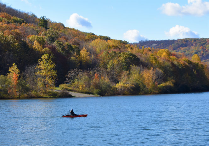
A fisherman enjoys some peaceful solitude on one of the Pequannock Watershed reservoirs.
Clinton Road and its surrounding wilderness have a somewhat creepy reputation for ghost sightings, witch gatherings, weird animal hybrids, and at least one infamous serial killer. I was attracted to this particular stretch on my New Jersey backroads motorcycle ride because it was recently repaved and weaves alongside the sun-kissed reservoirs and through colorful forests, but the area’s notoriety added to its allure.
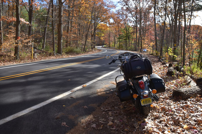
Among the fall colors, the author’s Vulcan stands ready to continue the cruise.
Several boat launches and parking areas provided opportunities to stretch my legs and drink in the scenery. Some riders are tempted to white‑knuckle it through the many twisties of Clinton Road, but I don’t recommend it. During the late fall rutting season, deer are hyperactive and as plentiful as flies on a cow patty. Besides, a slow cruise gives you time to appreciate the beauty.
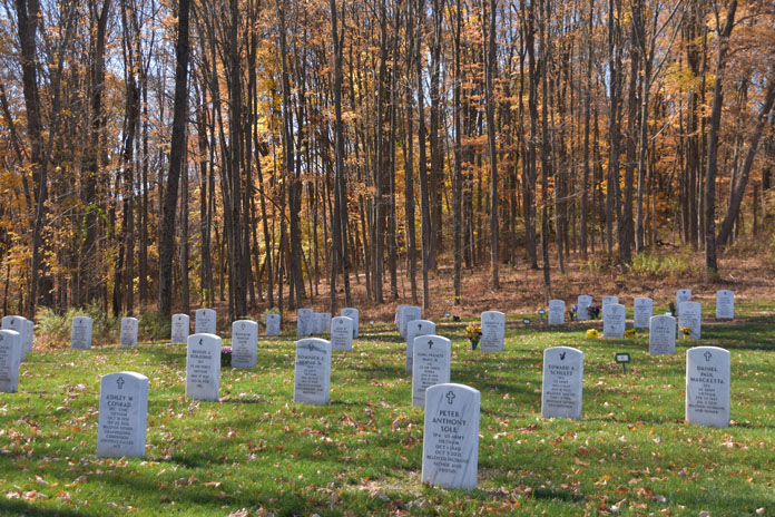
However, as I turned off Clinton Road and rode west on the mostly rural State Route 23, I ramped up the pace. The crisp, pure air caressing my face was invigorating. At Hamburg, I picked up State Route 94. Rumbling south, I spotted the Northern New Jersey Veterans Memorial Cemetery and stopped to pay my respects. Walking through the cemetery, you cannot help but be overwhelmed with emotion and appreciation for those who served our country and now rest in this hallowed ground.
Headstones at Northern New Jersey Veterans Memorial Cemetery honor fallen soldiers.
Continuing south, SR‑94 passes through Newton, a bustling small town, and then into lush farmland, with New Jersey’s western mountains rising on the horizon like a fortress wall.
County Road 521 rolls through picturesque New Jersey farmland.
In Blairstown, I stopped for lunch at the Blairstown Diner, which has been family owned and operated for over 70 years and has tasty food and authentic retro decor. The diner was featured in the original Friday the 13th film, and in the hills of nearby Hardwick, Boy Scout Camp No‑Be‑Bo‑Sco stood in for the film’s major setting, Camp Crystal Lake.
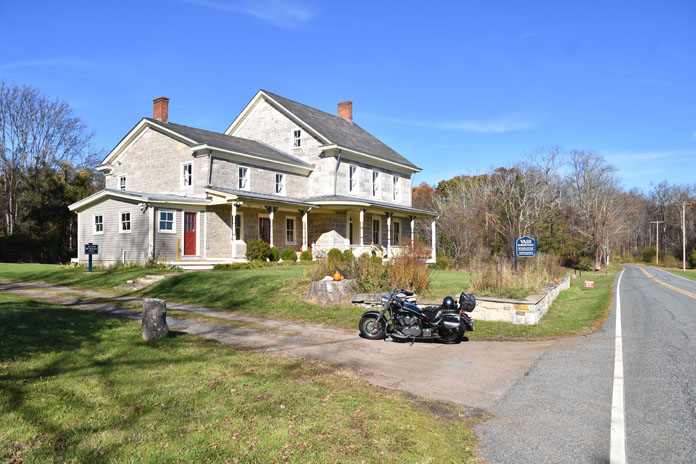
From Blairstown, I wound my way north on the rolling County Road 521, stopping briefly at the scenic White Lake Natural Resource Area and the historic Vass Farmstead. Built in 1812 and listed in the National Registry of Historic Places, it is worth a stop.
The restored 19th century Vass Farmstead, now co‑owned by the Ridge and Valley Conservancy and the state of New Jersey, overlooks the White Lake Natural Resource Area.
At Stillwater, I turned left onto County Road 617 and then followed a series of other rural roads. My Vulcan handled these wavy and weaving routes through farmland and forests with cool confidence. By the time I reached SR‑23 again, the sun was hanging low in the western sky. Heading south, I cracked the whip on my Vulcan and enjoyed its pulsating power as we rode down the highway.
Leaves on the ground means riding season in New Jersey is drawing to a close.
As I exited onto the tree‑lined County Road 513, my journey neared its end. Although my route was impromptu, the ride was perfect. Cruising on great roads through the beautiful countryside during the fall reminded me what riding is meant to be: unfettered by plans and going with the flow. There definitely will be more freewheeling rides in my future. As Peter Fonda’s sage old biker character Damien Blade said in Wild Hogs, “Lose the watches.”
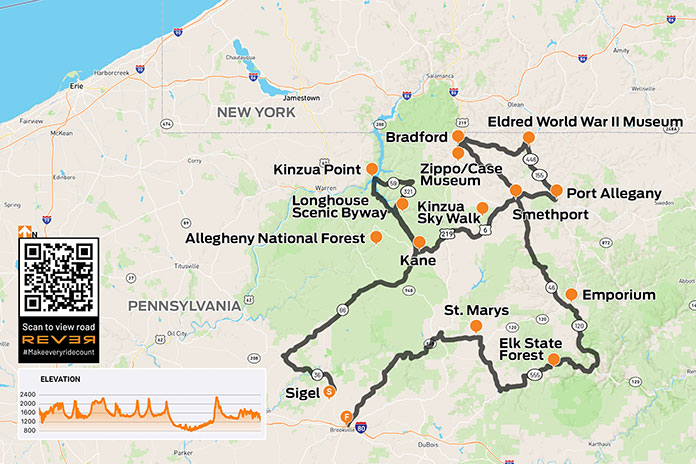
Getting there is half the fun, especially on this Allegheny National Forest motorcycle ride. Motorcyclists can find plenty of enjoyment riding the byways that wind through and around this lush region in Pennsylvania.
My father‑in‑law had a thing for the Allegheny National Forest in northwestern Pennsylvania. George would regularly leave his home in Jeannette, an industrial town east of Pittsburgh, and make the two‑hour trek to the family’s hunting camp nestled at the edge of the state’s only national forest.
Although he was raised a city boy, George longed for the quiet mountains. He loved to fish, canoe, and hike in the warmer months and hunt and cross‑country ski in the winter. He enjoyed meeting and talking with people year‑round.
Roads gently sweep through the forest, adding to the calming effect of the area.
George and I developed a friendship that went beyond the requisite in‑law geniality. We became close friends and confidants. As I began spending more time with George at camp, I discovered he not only loved the area but was also intimately familiar with nearly every small town, backroad, and beer garden across Clarion, Forest, Elk, and McKean counties. George seemed to know everyone, and everyone knew and loved George. As he introduced me to his old haunts and new friends, I became intrigued by what made this area so special to him.
Although my wife’s beloved father and my dear friend is now gone, Amy and I find ourselves driving the 100 miles north from the city nearly every weekend to work on the old camp property and take in the mystique of the region he held so dear. In the beginning, it was a way to stay connected and aid the healing process. Then we developed our own growing attachment to the area.
No longer having the benefit of the informative and entertaining car rides with George, I began going solo on a motorcycle (my own happy place) to explore more of “George’s Country.” Carving out a long weekend, I straddled my GS and headed north to investigate local attractions and, as George would, invest the time to talk with people and make new friends along the way.
(See RESOURCES at the end of the story for links to information about areas covered in this ride.)
George neither owned nor ever rode a motorcycle, although he did have a motorcycle endorsement. In Pennsylvania, there was a time when one could simply check boxes on the license renewal application to select endorsements. George chose car, motorcycle, commercial truck, and school bus. Fortunately, he stuck to cars. He said he thought he could make a motorcycle go but wasn’t confident he could get one to stop, which simply wouldn’t have fit his travel style since he enjoyed stopping often.
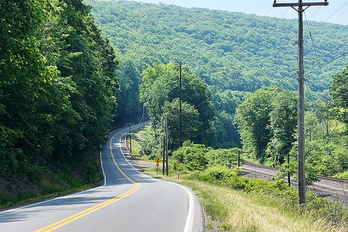
The farther into the forest I rode, the more my stress slipped away. The gently sweeping, rising, and falling roads pleasantly transitioned me to a calmer mind. A patchwork of idyllic farms and homesteads stretched across the valleys as folks offered friendly waves. Up here, life is simpler, less frenetic, and more down to earth.
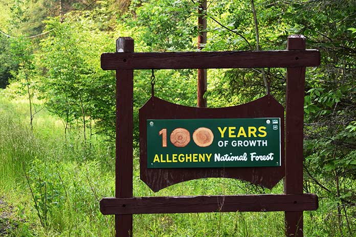
Along the road, I saw a sign proclaiming “100 Years of Growth.” The 514,000‑acre Allegheny National Forest celebrates its centennial in 2023, but unlike cities and suburbs, this is slow growth – unhurried evolution that builds strength and deep roots.
Established Sept. 24, 1923, Allegheny National Forest celebrates its 100th anniversary this year – although the roots run much deeper.
Towns and attractions in the area have powerful stories and deep histories that are easy to miss when one rides through a town or past an attraction without stopping. And here is where I must make a confession: I have a habit of allowing the momentum of a ride to urge me to keep rolling, and I convince myself I will revisit later when I have more time (I rarely do). Taking a cue from George, this ride would be about using the time I now have at my disposal.
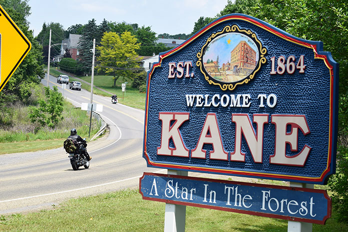
Traveling north on State Route 66, I saw a sign that proclaimed I had arrived at the gateway town of Kane, “A Star in the Forest.” This is also the junction with U.S. Route 6, known locally as PA Route 6, a favorite road among motorcyclists that stretches east/west across the length of the state.
The town of Kane is an ideal hub for exploring the Allegheny National Forest. With abundant route options and plenty of local attractions of its own, it’s a natural destination for riders.
At the entrance to Kane is a railroad crossing and historic rail station set against the skyline of 19th century buildings. Built around 1871, the Kane Depot is now a museum dedicated to preserving the town’s heritage, which includes the role a Kane citizen (not Citizen Kane) played in saving the Mexican wolf from extinction. Who knew? A stone outcropping hosts a sculpted wolf and cubs and a plaque that toplines the story so that people do know, and the museum tells the story with vivid exhibits.
I idled into town, and as I had committed to doing, I stopped, walked around the business district, and even picked up a tourist map of the area (available at nearly every establishment in the region and a great resource for finding “can’t miss” stops and favorite motorcycle routes; also see the Resources at the end of this article).
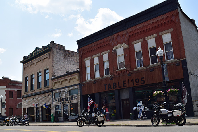
I love how these old towns are being revitalized with local businesses, restaurants, breweries, and shops – not the endless stretch of chains found near every city, suburb, and interstate exit. Here was Logyard Brewing, which specializes in sourcing ingredients native to the immediate Pensylvannia Wilds area. I was still on my ride so didn’t partake, but I did poke my head inside for a look. Very cool. Similarly cool is Table 105, located next door. I knew I had the right place for lunch when I spotted the ’72 Indian minibike hanging on the wall (I had one as a kid). The atmosphere was an ideal mix of vintage local architecture, modern brew pub, and northwestern PA kindness. Taking my server’s suggestion, I ordered a barbecue chicken pizza that was nothing short of amazing.
A throwback to a kinder, more social time. Connecting with the local folks and other travelers is what these small towns are (re)made for.
With a full belly and a few hours of sun left, I pointed the bike north for a loop up to Kinzua Point and back. A gentle ride along State Route 321 traced the western shore of the Allegheny River. At 321’s terminus, a left on State Route 59 took me deeper into the trees. Campsites, recreation areas, trails, and scenic overlooks abound, although one would never know if not for the signs since each is tucked away in the trees. Resisting my natural inclination to press on, I turned at the Rimrock Overlook sign. A narrow and winding well‑paved path through the trees is followed by a short, easy walk to a spot where the limited view dramatically opens to a majestic vista of forested mountains and the wide river below. I gave George a virtual high‑five.
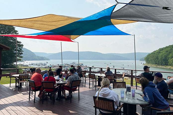
Back on Route 59 heading west, the forest opens to spectacular views of pristine water. This is the Allegheny River where its expanse forms the roughly 10,000‑acre Allegheny Reservoir thanks to the Kinzua Dam – one of the largest dams east of the Mississippi.
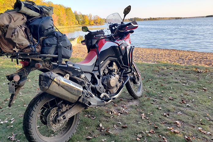
Created by the Kinzua Dam, the immense Allegheny Reservoir is inviting for boaters, diners, and sightseers.
As the sun began its downward journey, I began my own, turning south on the Longhouse National Scenic Byway, where I was met with more of the twisting, rising, and falling terrain that makes me glad to be on a motorcycle. The path teased me with periodic peeks at the water to my left as I traced the opposite side of the river.
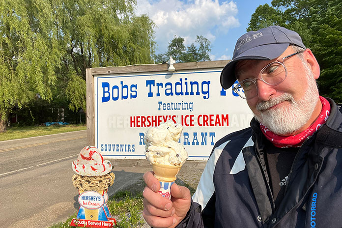
I made an obligatory stop for ice cream at Bob’s Trading Post. I ordered a small cone, but the kid behind the counter kept piling on scoops until I finally asked him to stop, reminding him that I ordered a small. He informed me that a “small” at Bob’s has three giant scoops of ice cream and said what I wanted was a “baby” cone. Sheepishly, I said to make it a baby cone then. With big baby cone in hand, I proceeded past the line of regular patrons who were clearly enjoying our exchange.
The author enjoys a “baby” cone at Bob’s Trading Post in Kane.
With the loop complete, I wheeled into the Kane Tourist Home & Motor Inn. It’s a throwback to old‑time travel when tourists would stay in converted old mansions (a “tourist home”) or later, in one of a row of private rooms with parking spots at each front door. It would be the motor inn for me. Built in 1952, it doesn’t seem to have changed much. The rooms have wood‑paneled walls and vintage framed pictures. Pink tile adorns the bathroom. As it was back then, there’s no television, but the new owners do provide wi‑fi in case a traveler can’t go a night without streaming something. I chose to sit on a chair outside my room, sip good bourbon, and watch neighborhood kids play outside (a rare sight where I live).
The Kane Tourist Home & Motor Inn gives motorcycle travelers a taste of old-time lodging, including affordability and parking just outside your room.
The motor inn was just off the main drag, so I walked to a quaint little winery called Twisted Vine where a delightful and bright young lady was behind the bar and a youngish couple were seated to my left. Surprisingly, folks weren’t absorbed by their mobile devices; they were engaged in conversation. I was welcomed into a pleasant chat with all of them, during which I learned more about the area, about how the town of Kane has been making a comeback, about local musicians, and more. Because I stopped, I made new friends. This is one of the things I enjoy so much about traveling by motorcycle. It gives me the opportunity to escape and, at the same time, reconnect with life in a more meaningful way. Nothing fake. No agendas. Just engagement with good people in an atmosphere that is relaxed enough to invite conversation. More and more, I came to understand George’s fascination with this area.
Hidden down narrow lanes are gems like this spectacular view from the Rimrock Overlook.
One Becomes Two
My friend and fellow motorcycle safety expert Hal Deily joined me the next day for the rest of my Allegheny National Forest motorcycle ride. It was fun to see how Hal, a guy who has lived within the city limits of Pittsburgh his entire life, was enjoying the vast ancient forests, the well‑preserved countryside, and the hospitality of small‑town communities. Being naturally social, Hal immediately struck up conversations with wait staff, shop owners, and patrons. He and I got into our typical back‑and‑forth banter that entertained the locals (we think), and as I did several times on this journey, I thought back to how George and his brother‑in‑law Billy would often be the center of attention anywhere they went as they shared stories and told old jokes to new audiences. They were never obnoxious, just good spirited and lighthearted people who were fun to be around.
The author plugs into the local heritage.
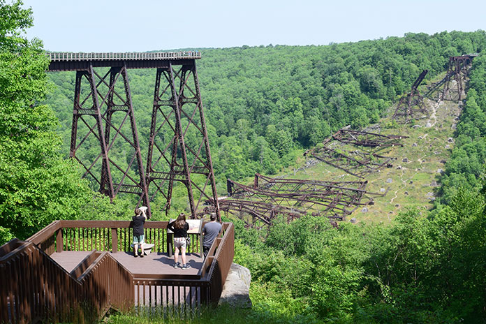
After breakfast on PA Route 6 at the Barrel House, we continued toward the Kinzua Sky Walk, rated “One of the Top 10 Most Beautiful Skywalks and Viewpoints in the World,” at Kinzua Bridge State Park. Once the highest and longest railroad viaduct in the world, a direct tornado strike in 2003 wiped out more than half of its span. The mangled wreckage of steel towers rests in perpetuity on the valley floor more than 200 feet below what is now a prime viewing area at the far end of the surviving structure. This is a must‑see destination for any ride in the area, evidenced by the volume of motorcycles in the parking lot.
A must-see, the Kinzua Sky Walk takes visitors to the edge of what was once the world’s highest railroad viaduct (before it took a direct tornado hit).
In addition to delightfully laid‑back two‑lane riding, PA Route 6 presents many rewarding sights and significant historical areas of interest. Magnificent Victorian mansions line the way through downtown Smethport, evidence of a game of architectural one‑upmanship played by the area’s lumber barons during the 19th‑century timber boom. There, Hal and I stumbled upon Old Town Smethport, the home of “America’s First Christmas Store.” It’s also an eclectic collection of historical displays that includes old‑fashioned toys, an original stagecoach, a vintage delivery truck, a rustic log cabin, and even a Civil War cannon and artillery. I can’t help but think George would have loved this place. And I’m glad Hal and I took the time to stop, even though it meant shedding all our riding gear once again.
Tree-lined streets and well-preserved Victorian-era mansions of the logging-baron days guide the way through Smethport.
Just west of Port Allegany is an eye‑catching structure along the road called Lynn Hall. Built in the Modernist style (think Frank Lloyd Wright), this stunning 1930s residence is an unexpected gem in the woods. But don’t blink or you’ll miss it!
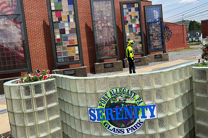
Port Allegany is surrounded by natural resources ideal for making glass. That’s what brought Pierce Glass to the town in 1917, followed later by Pittsburgh Corning, makers of architectural glass block distributed worldwide. That proud heritage is celebrated in the Serenity Glass Park, an art display in the heart of town. Murals and sculptures made of colored glass fill the garden. I wish we could have viewed it after dark when the garden is electrified by lights. It must be spectacular.
Hal checks out the impressive glass sculptures in Port Allegany’s Serenity Glass Park.
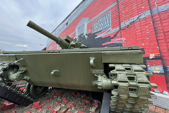
Following a tip, Hal and I turned north onto State Route 155 and then 446 toward the town of Eldred to visit the Eldred World War II Museum. This small community nestled in quiet hills was the site of a munitions plant during the war, producing millions of bombs, shells, and fuses in support of America’s war effort. The museum features a fascinating collection of period artifacts, photos, vehicles, uniforms, weapons, and models. There is a stunning amount of history housed here (just be ready for a curator who is anxious to provide abundant historical – and editorial – commentary).
The extensive World War II Museum in Eldridge draws visitors from near and far.
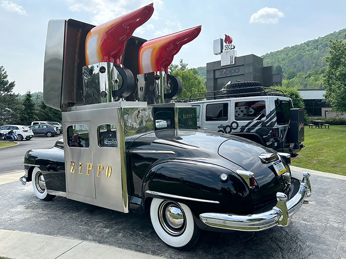
No Allegheny National Forest motorcycle ride is complete without a stop in Bradford and the Zippo/Case Museum. This world‑class museum wraps the visitor in living history as they walk through the back stories of Zippo windproof lighters and Case knives. Photos, videos, vintage advertising, promotional vehicles, and prototype products bring the stories to life, cleverly showcasing how the products have become part of the fabric of American (and world) culture. I was fascinated by a display of destroyed lighters that had been returned for repair or replacement. (Zippo’s guarantee has always been, “It works, or we fix it for free.”)
The Zippo windproof lighter and Case cutlery museum is world-class. There’s plenty to keep visitors entertained for hours. Seeing this Zippo promotional car was worth the trip!
Hal and I then took a ride through downtown past the Marilyn Horne Museum, but we were too late to catch this tribute to Bradford’s big opera star, who was once described as “probably the greatest singer in the world” by Opera News. Instead, we wound our way to Bradford Brew Station for a late, nonalcoholic lunch. The brewery has a great reputation, but we still had to ride to our hotel across town. In contrast to the prior night in Kane, we grabbed rooms in a modern Holiday Inn Express that was both affordable and perfectly comfortable. A brisk walk through town to the Papa Scoop’s ice cream stand near Zippo corporate headquarters was the perfect nightcap.
In the morning, Hal and I opted to ride from Bradford down through Emporium and into the Elk State Forest where we picked up the fabulous State Route 555 along Sinnemahoning Creek to Benezette. A little side loop on Winslow Hill Road rewarded us with fun two‑lane riding and spectacular elk viewing areas.
A quick sprint up to St. Marys (home of Straub Brewery) was followed by a jaunt to the quaint town of Ridgeway for lunch where Hal and I channeled George and Billy once more, telling polite jokes and laughing with the server and other guests. You just can’t help but be jovial here. And maybe, in the end, I guess that’s what makes the forest so special: It brings out the best in people. By George…I think I’ve got it!
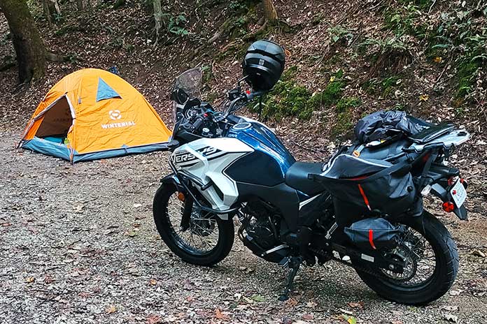
My campsite at Kanawha Falls State Park on my West Virginia motorcycle ride.
We all have beliefs about what’s expected of a motorcycle camper, and sometimes it takes a certain situation to bring those expectations to the surface. For me, it took heavy rain on a mountain road during a West Virginia motorcycle ride to point out my principles on motorcycle travel and what type of person I thought I needed to be to do it.
A Beautiful Beginning
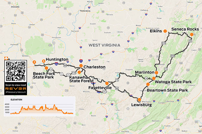
Everything was going according to plan. I was on a solo motorcycle camping trip across central West Virginia along the Midland Trail National Scenic Byway (U.S. Route 60), and I spent my first night at the Kanawha State Forest campground. My campsite was pleasantly remote and on top of a bridge that crossed a scenic running creek. Waking up to the sound of gently flowing water was an energizing start to what would be an amazing day – or so I thought.
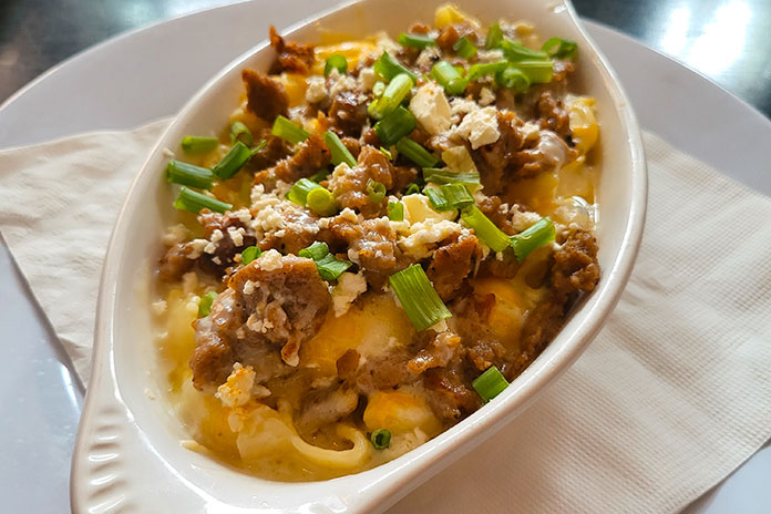
I packed up my gear and headed into Charleston for an early lunch. I chose Adelphia Sports Bar & Grille in the historic downtown area and enjoyed the best dish I’ve eaten on any of my dozen or so motorcycle camping trips to date: gyro macaroni and cheese, perfectly spiced gyro meat atop pasta shells and a creamy, cheesy sauce. I was in heaven.
I had never seen a gyro mac and cheese dish offered anywhere before I ordered it at Adelphia Sports Bar & Grille in Charleston, and it turned out to be one of the most comforting dishes I’ve had.
The First Rainstorm
Having thoroughly enjoyed my meal, I took off along the curvy Route 60 on my way to Lewisburg. Along the way, it started to drizzle, but my waterproof gear was doing its job. Then the rain intensified from a drizzle to a shower and eventually a torrential downpour. The road became curvier, with switchbacks and hairpins that would have been delightful on dry pavement but were treacherous when wet. Not trusting my tires as sheets of water ran across the corners, I was stiff and tense. Having nowhere to stop for cover, I had no choice but to press on.
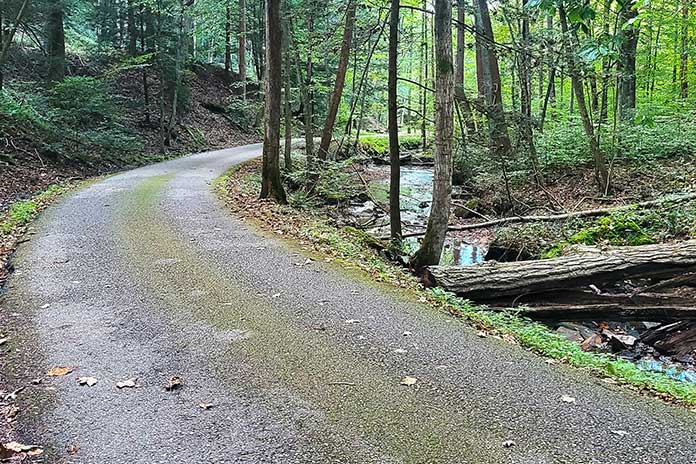
Kanawha Falls State Park has campsites in a serene landscape covered in soft moss, which muffled surrounding noises and created a feeling of complete solitude.
Seeking relief, I consulted the navigation app on my phone and found a shortcut. To my dismay, the shortcut turned out to be a one‑lane road with no shoulder – my least favorite type of road – and was no less treacherous in terms of cornering. I accidentally took a wrong turn onto a deserted side road, and then the navigation rerouted me to a sharp, steep downhill left turn that would lead to another side route. I froze, uncomfortable with such a tight turn on wet ground.
Deciding that I should go back to Route 60, which at least had lane lines and a shoulder, I suddenly noticed two giant German shepherds nearby, glaring and growling at me. As they both started running toward me, I quickly accelerated and turned down that steep incline to get out of there faster than they could run. That’s one way to initiate a turn you don’t want to take.
I continued on the narrow, curvy road. My nerves were frayed by this point, and I even had a desperate thought that I should pull over and call my husband to come get me – a ridiculous notion, given that I was nearly eight hours away from home.
I finally made it through the not‑so‑shortcut and back onto Route 60, bitter that I could have just stayed on it the whole time. I started seeing signs for Lewisburg and have never been so relieved as when I pulled into Hill & Holler, the pizza place I had programmed into my phone.
Carbohydrate Therapy
After taking off my soaking wet gear and ordering a 12‑inch pizza all for myself, I settled in and let my frazzled nerves relax. I wasn’t sure what to do next. My reserved campsite was still an hour away – also along mountain roads. This time, the roads were ones that I had never ridden before, and on the map, they looked as curvy as where I had just been.
Deep down, I wanted to get a hotel. The thought of riding another hour or two in unrelenting heavy rain and setting up a soggy campsite sounded downright miserable. I messaged my husband and some of my riding friends; he supported the hotel idea, but they encouraged me to press on. They said it would be worth it, that I could do it, that there was no giving up or turning back. I felt guilty for thinking about giving up and getting a hotel, even though I knew it was the safest thing to do.
Charleston, West Virginia’s capital that’s bisected by the Kanawha River, has a charming historic downtown district.
Never one to back down from a challenge, I decided to continue, leaving the pizza place after cleaning up the massive puddles my dripping gear had left on their floor. Once outside, I discovered it was raining even harder. I hopped on and rode to the nearest gas station to fill up, and as my visor fogged up completely, I decided enough was enough. I found a hotel less than half a mile down the street and checked in. After carrying my luggage up the stairs and stripping off my water‑logged gear, I collapsed onto the bed.
At this point, I felt terrible about myself and my decision. I had given up, taken the easy way out, let down myself and everyone who was cheering me on. I realized I had high expectations of myself as a motorcycle camper – that I should be tough and resilient, but instead I was a wuss. Other female moto campers I had seen on social media portrayed themselves as “hardcore” as they slept sitting up or spent the night under a bridge. Why couldn’t I make it through a little rain?
After a hot shower and some takeout, I started feeling better about my decision. Staying in a hotel allowed me to regroup and relax, and it was nice to drift off to sleep in a dry, comfortable bed.
Bears and Boulders on a West Virginia Motorcycle Ride
The next day, I awoke to sunny skies and headed north on U.S. Route 219, also known as the Seneca Trail and part of the Seneca Skyway loop route. The ride was thrilling. For a while, I forgot I was on my Kawasaki Versys‑X 300 adventure bike since it was handling the curves like my Ninja 400.
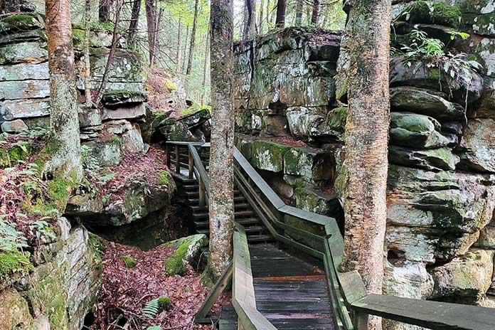
After a thoroughly enjoyable half‑hour of riding, I dropped my kickstand at Beartown State Park, a must‑stop for an avid hiker like me. Beartown has one of the most unique hiking trails I’ve ever experienced, a half‑mile stroll on wooden boardwalks that wind through imposing rock formations on all sides. I was one of the only people there, so walking through this “town” of large boulders was quiet, a little eerie, and the perfect reward after the trials I’d been through the previous day.
Beartown State Park was named because the pioneers thought it resembled a town for bears since the rocks are roughly the size and shape of buildings.
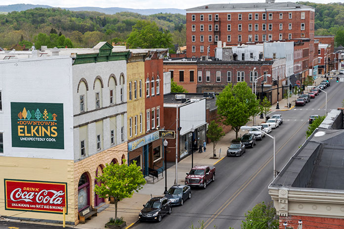
Route 219 took me all the way north to Elkins, a charming historic town that serves as the seat of Randolph County. Elkins was a coal and timber town in the late 19th and early 20th centuries. Its revitalized downtown has restaurants, bars, shops, lodging, and museums centered around the restored Elkins Depot, where you can take a scenic train ride on the Durban & Greenbrier Valley Railroad. Scottie’s of Elkins, full of locals and serving hearty, delicious comfort food, was the perfect place for lunch.
West Virginia certainly lives up to its nickname, The Mountain State. Tucked between the rolling Appalachian peaks are cozy burgs like Elkins, which are great places to stay, eat, and enjoy other off-bike activities.
Riding east out of Elkins, U.S. Route 33 follows a winding path up and over the Allegheny Mountains, crossing several rivers along the way to Seneca Rocks, a scenic rock formation that’s popular among climbers. I stayed on Route 33 to Judy Gap, where I continued south on State Route 28, enjoying curves and sunshine all the way to Watoga State Park.
After setting up my campsite, I walked to the bathhouse and was stopped by a man in his 70s who was in better shape than I am. He yelled out from across the yard, “Are you the biker lady?” I laughed and responded, “Yes sir, that’s me.”
He asked where I had come from and where I was going. When I mentioned I had planned to spend the previous night here but stayed in a hotel instead because of the rain, he exclaimed, “Oh, you sissy!” I was taken aback and momentarily hurt until he laughed and followed his insult with the remark, “Yea right. I’ve never even seen a female on a solo motorcycle trip here in 17 years of being a camp host.”
Point taken: I couldn’t possibly be a sissy given what I was out here doing. This realization and the external validation were a relief.
Elkins Depot has a welcome center with information about the area. You can also board a train for a different sort of scenic ride through the mountains.
Return to Route 39 and Motorcycle Camaraderie
Rain started again in the evening, and while it had stopped by morning, my tent and tarp were still wet when I packed them up. My final campground of the trip was at Beech Fork State Park, but I had a few stops I wanted to make along the way. Plus, I wanted to ride State Route 39, which was the other reason I had come to this area – a man on a previous trip had given me a coin and pin commemorating this road (see “Along the Midland Trail: A West Virginia Motorcycle Trip”), but I didn’t get a chance to ride it at that time.
The landscape of the Seneca Trail (U.S. Route 219) is a remarkable mixture of rolling hills and mountains.
For this trip, I had taken a laissez‑faire approach to planning: Pick a few destinations and the routes in between them and see what happens. This was different from my usual meticulous planning, and I ended up missing out on a few opportunities. I assumed that Route 39 would be a curvy road through towns and countryside like Route 60, but it runs through a national forest, isn’t particularly curvy, and has plenty of tourist stops along the way. Trying to beat the oncoming rain and knowing I had limited time to get to my next campsite, I didn’t stop at any of them, which I regret.
I continued south on U.S. Route 19 back to Route 60 when I got stuck in yet another rainstorm, this time on a four‑lane highway. Given the recent relinquishing of my harsh, self‑imposed rules about pressing on in misery, it was an easy decision to stop in Fayetteville at Water Stone Outdoors – a befitting name for my situation.
My Kawasaki Versys-X 300 handled well in the rain, but I still felt tense and nervous on steep, winding roads.
The store had a cafe inside, and my weather app said the rain would pass in about an hour, so I settled in with a warm and comforting chai latte while perusing their clothing options, again dripping puddles all over the floor.
A local woman approached me and said they didn’t see many motorcycle travelers around there. She asked if I was alone. When I replied that I was, she gave me a fist bump and said, “Wow, so you’re a badass!”
This woman didn’t know that I had stayed in a hotel to escape the rain nor did she care that I had ducked into a cafe to do it again. She just knew I was out here traveling on a bike, and that was enough in her book. It should be enough in my book as well.
As the sun peeked out of the clouds and the rain stopped, I headed to Beech Fork State Park. On previous trips, I had gone to one homebase campground and then branched out on day trips from there. This time, I had planned an actual tour where I stopped at a new place each night and packed up camp in the morning.
My campsite at Beech Fork Lake was a beautiful retreat.
I found this to be exhausting, even with my hotel stay in the middle of it. After packing up my kit at Watoga, I had thought briefly about pushing through and riding the eight hours home just so I wouldn’t have to set up camp again. But I reminded myself that camping was half the reason I was on the trip and I would enjoy it once I was there, feeling the weight of my beloved camp equipment in my hands as I unpacked it. And for once, the weather looked clear for the next two days.
I arrived at Beech Fork State Park and found a perfect campsite with a stunning view of a lake. I set up camp and enjoyed the quiet solitude until I heard the familiar sound of a motorcycle exhaust. A large BMW adventure bike loaded up with gear and piloted by a man in matching textile apparel pulled around the circle in front of my campsite.
“I heard there was another motorcyclist in the campground,” he said through his helmet. “I thought I might stop by and say hello.”
We chatted briefly about where we were from and where we were headed. “You’re the only other traveling motorcyclist I’ve talked to on one of my trips,” he told me, and I indicated that he was the same. I was reminded of my recent realizations thanks to the camp host at Watoga and the woman at Water Stone Outdoors. They had both taught me that being out on a bike was enough, regardless of whether you’re traveling across the world or just across a state, roughing it every night in the backcountry or sleeping in a campground with amenities, braving the elements or enjoying warm and safe shelter indoors.
Looking at this fellow adventurer, knowing we were both rare individuals among travelers, sealed the deal that my expectations of myself as a moto camper were unfair and unrealistic. I shrugged off the unnecessary emotional weight right there on the shore of Beech Fork Lake.
The sun rising above the mist on Beech Fork Lake was the perfect send-off on my final day in West Virginia.
If you need permission to ditch staunch expectations about what type of person you should be to travel on your motorcycle, take it from me: You are enough, just as you are.
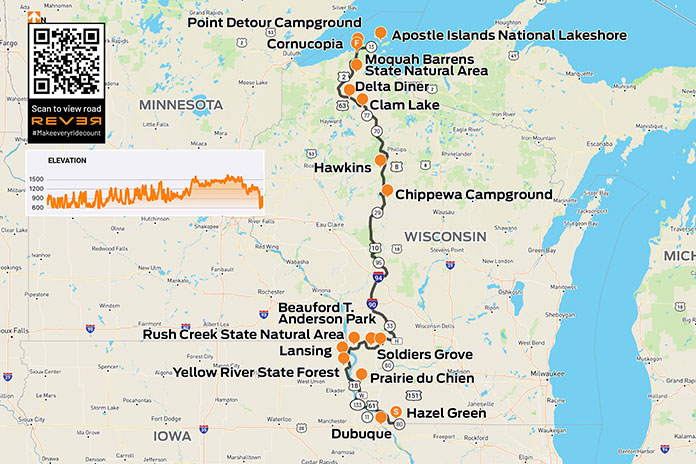
As I reached for the pump handle to fill up at the start of this trip, I suddenly realized my hydration pack wasn’t on my back. Doubt flooded in, and I wondered if this trip on the Trans Wisconsin Adventure Trail was a bad idea. After returning home to retrieve my pack, I scolded myself for failing right out of the gate.
The Trans Wisconsin Adventure Trail is also known as the TWAT, a term I use for “one who tweets” and the British use for an obnoxious person. Though not a term one hears in polite company, this TWAT is a 635-mile dual-sport and adventure motorcycle route that runs from the Illinois/Wisconsin border in the south to the shore of Lake Superior in the north. There are no maps of the route, but you can download a free GPX track at the Trans Wisconsin Trail website.
The TWAT was to be my first time riding off-road. What was I thinking?
To prepare myself, I binged hours of off-road riding instruction on YouTube by Bret Tkacs, Dusty Wessels, and Eric Lange. Their tips and techniques came back to me when I needed them most. YouTube was also my tutor for what to pack. I’d watch a video, hit pause, and click over to Amazon to load up my cart. I felt like a kid on Christmas opening boxes and setting up fake camp in my backyard to try out everything.
My Honda Africa Twin was the perfect bike for the 635-mile trek across Wisconsin.
The Trans Wisconsin Adventure Trail starts just south of Hazel Green, Wisconsin. I rode past the gravel road near “The Point of Beginning” historical marker on State Route 80 twice before realizing it was my starting point. There was no sign for the TWAT, but the route I had uploaded to the REVER app indicated I was in the right place. My adventure had begun!
The standard advice is to run knobbies on an adventure route, but after all the money I’d spent on gear, I figured replacing the perfectly good 90/10 tires on my Honda Africa Twin would tip Mrs. Trimble over the edge. Rather than make camping a permanent situation, I opted to use my existing rubber.
The trail is lush in spring and summer.
The first day had the most pavement of the three. Intermittent road stretches were a welcome break for a novice like me. The limited traction off-road was unnerving, so the grippy bits helped relieve the tension. Hour by hour, my confidence and skills improved.
The Midwest is renowned for its flat landscape and laser-straight roads, which results from most of the region being scraped clean by glaciers during the last ice age. But there’s a small territory where Wisconsin, Minnesota, Iowa, and Illinois meet that was not covered by ice and thus lacks glacial deposits known as drift. Known as the Driftless Area, this playground of hills, ridges, valleys, and rock formations was a highlight of Day 1.
Arriving at a campground like this makes a long day on the trail worthwhile.
The first day also took me over the Mississippi River for some riding in Iowa, which is a little odd for a route across Wisconsin, but the ride through the Yellow River State Forest made it worthwhile. After crossing back into Wisconsin, I rode through the Rush Creek State Natural Area.
I spent my first night camping in Soldiers Grove, right in town at Beauford T. Anderson Park. Stomach issues had me in and out of my tent all night, and dew made everything inside unpleasantly damp. As the sun rose, I hung my things up to dry. Drinking instant coffee from my Jet-Boil, I questioned my decision to camp, which led to more second-guessing about the entire adventure. I rolled out of town disgusted by how soft I had become.
The next day, I felt more comfortable riding off-road, and gratitude soon replaced despair. The trail meandered through hills covered in baby-head-sized rocks and water-filled bottoms that hid all sorts of bar-yanking surprises. Wrestling my Africa Twin along trails in the Chequamegon-Nicolet National Forest left me drenched with sweat.
When I poked out onto a paved road, the sun was getting low, and I worried about finding a hotel. A half-mile down the road, I passed a sign for Chippewa Campground, which was on my must-visit list. Rather than suffer self-flagellation in a hotel room, I opted to camp. Two days of riding had me so beat that I dropped my bike while trying to lower the kickstand.
Late afternoon sunlight shines on the lake and filters through the trees at Chippewa Campground.
The campground’s coin-operated shower revived me. For $2 in change, the sweat and dirt disappeared down the drain while the satisfaction of completing two days of off-road exploration lingered. I strolled to a gas station for a six-pack and a cup of ice that I filled with Jameson. That night by the campfire, I felt like a new man. A sense of accomplishment and a nice Irish whiskey buzz made for a more enjoyable night in the woods.
Day 3: Enter Sandman
The third day on the Trans Wisconsin Adventure Trail called for sand, which had seemed treacherous on the YouTube training videos. So far, I’d only taken a few dabs and no falls, so I expected this to be my day to eat humble pie. Not far in, I experienced my first tank slapper after putting too much weight on the front wheel. Rather than panic, I drew upon the wisdom of my YouTube tutors – Don’t cut the power abruptly; Lean back and give it gas; Ride it out until the bike stabilizes – and I recovered. Soon I was sitting back against my dry bag and flying through the sugary stuff without a care in the world.
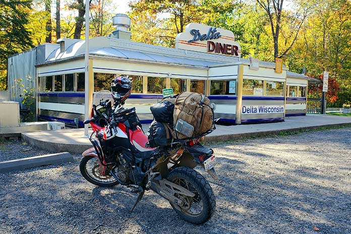
At a stop for gas, I asked the attendant how far it was to the Delta Diner. He said it was about an hour away, so I bought some beef jerky to hold me over. Because I was on the TWAT and not driving by car, it took three hours before I finlly pulled off the trail at the diner, a chrome-and-neon oasis in the middle of nowhere.
The parking lot was empty except for an older couple gearing up to climb back on their BMWs. After removing my sweaty gear and helmet, I nodded to them as I headed for the door. As I reached the top step, the lady said, “They’re closed.” What a gut punch. I was tired and hungry, and for hours I had been fantasizing about a juicy burger with a side of fries and an ice-cold Coke. Dry jerky and warm, plastic-tasting water from my hydration pack was a poor substitute.
As a big fan of classic diners, it broke my heart (and pained my stomach) to find the Delta Diner closed. I’ll be back.
North of Delta, I crossed U.S. Route 2 and entered the final stretch. After riding through the Moquah Barrens State Natural Area, I rolled through the town of Cornucopia. A few more county roads later, I arrived at a dirt cul-de-sac by the Point Detour Campground near Apostle Islands National Lakeshore. A faint trail led into the woods and came out at a dilapidated set of stairs down to Lake Superior, and I worked my way to the rocky shore.
As I sat smoking the cigar I saved for the occasion, I felt humbled by the setting and the moment. I had overcome self-doubt, completed my journey, and even learned to love sand.
At the end of the trail on Lake Superior, with views of the Apostle Islands.
The parking lot of the Bellvale Farms Creamery in Warwick, New York, provides scenic views of the surrounding valleys. The Appalachian Trail crosses State Route 17A nearby, so this is a popular stop for hikers hungry for ice cream.
A good ride doesn’t have to be a long one. With only $10’s worth of gas, I set out to see how much fun I could have cruising around close to home on a New Jersey and New York motorcycle ride, and I was not disappointed.
It was a beautiful spring day with low humidity and temperatures in the 70s. I went out to the garage to warm up my 1990 BMW K 75, a bike known as the “Flying Brick.” Adding a little throttle as it idled, the BMW sang its familiar run run run run. I’ve owned it for 32 years, and with 28,000 miles on the clock, it’s barely broken in.
With its 750cc inline-Triple, waterproof saddlebags, and a cafe windscreen, some motorcycle reviews called the K 75 the perfect bike. It can take you around the corner for a quart of milk or around the world. I gassed her up, getting only a couple gallons for my $10. The gas station attendant admired the BMW’s silver paint and blue pinstripes and asked if it was new. I told him it was almost twice as old as he was.
The days of the 1,000-mile weekend trip are over for me. Most of my motorcycle jaunts these days, whether alone or with friends, are designed around breakfast, lunch, and a late afternoon snack.
The Village Buzz Cafe in Greenwood Lake is one of my go-to spots for breakfast or lunch. If you drop in, tell Katie I sent you!
From my home in Ramsey, New Jersey, it was a quick ride north on State Route 17 to Auntie El’s Farm Market in Sloatsburg, New York. At one time just a small shack with plants in summer and Christmas trees in winter, it’s now half a block long and sells plants, garden art, and fresh fruit and vegetables. But for me, it’s all about Auntie El’s bakery, which serves up freshly baked pastries, pies, and cookies. I enjoyed a warm apple turnover with coffee.
Next, I veered west on Sterling Mine Road, curved my way back into New Jersey, and rode past Ringwood Manor, a 724-acre park with rolling hills and a babbling brook. A slow ride through the park is usually a nice diversion, but on this trip I kept going and turned onto Margaret King Avenue. A few miles later, I turned west onto Greenwood Lake Turnpike and crossed over the Monksville Reservoir, which provides water for northern New Jersey and recreation for kayakers, paddleboarders, and anglers.
It was not quite 9 a.m., and the lake shimmered in the morning light. Anglers were out trying their luck. I slipped into the parking lot with my K 75 making about as much noise as a sewing machine – even the geese on the shoreline were unperturbed. Walking out on the dock provided a taste of the natural beauty that’s so close to home.
Monksville Reservoir was created in the late ’80s by damming the Wanaque River. The idyllic lake is popular among boaters and anglers.
Continuing on Greenwood Lake Turnpike took me to its namesake body of water, which is a narrow 7-mile lake that straddles the border of New York and New Jersey. From the turnpike I could see boats bobbing in the water at South Shore Marina, where years ago I kept “Dumb Idea,” my 19-foot day sailer. Anyone who has owned a boat will understand the name. The road, which becomes Warwick Turnpike, was all mine as I curved a large arc around Upper Greenwood Lake.
My next stop was Wawayanda State Park, a wonderful 34,350-acre preserve with 60 miles of trails and a beautiful spring-fed lake with a wide swimming beach, a boat launch, and kayak rentals. It’s a great place to take a short break and enjoy the sun sparkling on the lake. I was only burning $10’s worth of gas, so there was no need to rush.
The black dirt and onion farms of Pine Island, New York.
I crossed back into New York, turned west onto Route 94, then north onto Sanfordville Road. Turning west on Pine Island Turnpike took me to Pine Island, an area famous for its onion farms and some of the blackest dirt you’ve ever seen. After a quick stop in town, where there’s a great restaurant called The Jolly Onion, I backtracked on the turnpike and turned north on Little York Road, a small country road with views of the fields and small tidy houses in dappled sunlight. I stopped at the Warwick Valley Winery & Distillery, which has a cafe, picnic tables, and acres of land. As I strolled the grounds, I admired the blooming roses and made a note to return for a longer visit.
Continuing east on Pine Island Turnpike, I turned east at West Street and rode into the heart of Warwick, a charming town full of cafes and restaurants. There’s free parking in a large public lot right off Main Street. I sought out a power outlet to recharge my phone and had a slice of pizza while I waited.
Farther down Main Street at the far end of town is a large public park with benches under towering oak trees, providing shade that complemented the spring breeze. On a little hill is the Old School Baptist Meeting House, a majestic white church built in 1810. It’s now maintained by the Warwick Historical Society, and I enjoyed a quick tour.
The Old School Baptist Meeting House in Warwick.
I left Warwick by riding south on Oakland Avenue (Route 94) and then turning east on Galloway Road (State Route 17A). A left turn on Kain Road took me to Bellvale Farms Creamery, which looks like a Norman Rockwell painting of a farmhouse and has an expansive view of a valley full of farms. It also serves delicious ice cream, but I didn’t want to spoil my appetite.
One of my favorite stops for breakfast or lunch is The Village Buzz Cafe, which is in the heart of the Village of Greenwood Lake on Windermere Avenue just off Route 17A. The cafe serves up hometown cooking with welcoming smiles all around, and its menu includes all-day breakfast, sandwiches, and sweets. Their handcut home-fried potatoes with onions alone are worth a stop. Out front there’s a chalkboard with positive affirmations written in different colors, and they reminded me of how lucky I was to be up on two wheels on a gorgeous day.
Nothing beats ice cream straight from the source.
By the time I returned home, I’d only ridden 89 miles, but the $10 I spent was a bargain for a great day of exploring hills, lakes, and curves.
Scenic U.S. Route 6 near Coudersport, Pennsylvania.
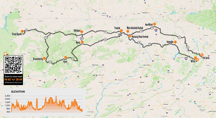
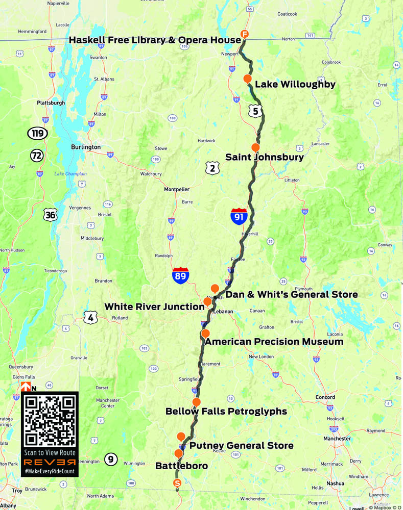
When I hear the first whispers of the siren’s call to hit the road, my desire to rumble off on a multiday trip slowly rises to a crescendo until I have no other choice but to pack my Kawasaki Vulcan 900 Classic LT and ride toward the horizon. On a motorcycle tour such as the one I recently took into the Pennsylvania Wilds on U.S. Route 6, the journey is as important as the destination, so I take time to explore along the way.
Regardless of the destination, the trip itself must satisfy my need for the pastoral – wild land, scenic roads, and the peaceful simplicity of small towns. Cruising U.S. Route 6 deep into the hinterlands of Pennsylvania fulfills all those criteria, making for a deeply enjoyable excursion.
Riding west on Pennsylvania’s famous Route 6, a designated scenic byway, takes you through the Endless Mountains region to the north-central part of the state, known as the Pennsylvania Wilds. This region is devoid of urban/suburban sprawl and comprises over 2 million acres of public land, 29 state parks, eight state forests, ample farmland, and hundreds of miles of rural roadways to ride.
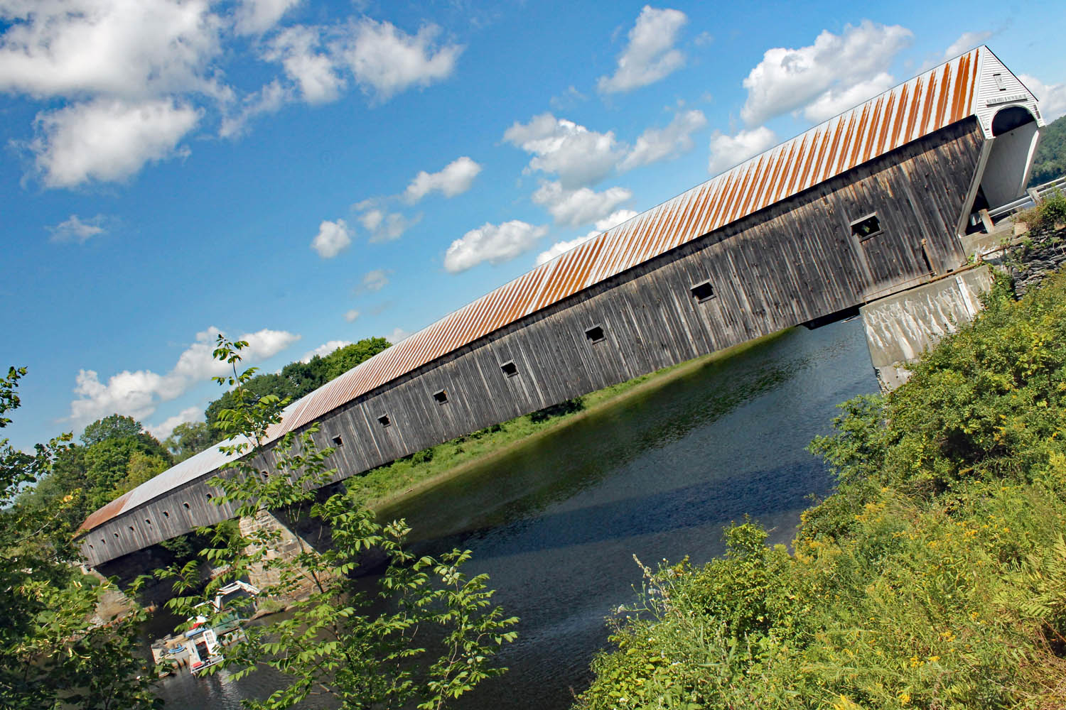
A covered bridge highlights the greenery that graces PA Route 706.
Route 6 provides a diverse and scenic ride through Pennsylvania, but it also traverses the entire country from Provincetown, Massachusetts, to Bishop, California. Construction began in 1926, and it is now the second longest road in the country at 3,227 miles. Route 6 through Pennsylvania is like a wilderness path leading modern-day explorers on steel steeds deep into the Keystone State’s hinterlands, home to bear, deer, coyote, rattlesnake, fox, bald eagle, and elk.
I began my journey by crossing into Pennsylvania from New Jersey on the Milford Bridge over the majestic Delaware River. From Milford, Route 6 begins a rolling, curving climb from the river to the highlands. Throttling on the power, I flew through forests and past ponds until reaching the big enchilada – or locally, the “Big Lake” – Lake Wallenpaupack. Thirteen miles in length, with 52 miles of shoreline and 5,700 acres of surface area, it is the second largest lake within Pennsylvania’s borders. There are six public recreations areas and a wide array of accommodations, outdoor activities, dining, and shopping.
The clear waters of Lake Wallenpaupack.
Wanting to savor this moment – and location – I turned south at PA Route 507 into a parking area and stretched my legs by walking along the shoreline of Lake Wallenpaupack and atop the dam. Route 6 passes the base of the dam as it continues to Hawley, one of the typical turn-of-the-century small towns along this route.
Mostly a two-lane rural highway, Route 6 does have a few congested areas along the way, such as in Honesdale, but Honesdale to Waymart is smooth sailing – or riding. The mountains around Waymart are capped with humongous wind turbines, which are an impressive sight, but I prefer my mountains au naturale.
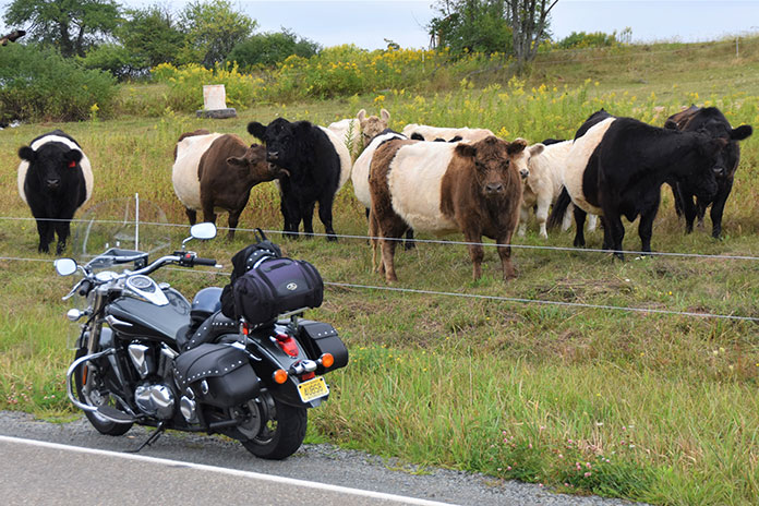
Scottish Belted Galloway cows are as tough as their native Scotland. They didn’t smile for the camera.
Past Mayfield, I left Route 6 and took PA Route 107 to avoid the major congestion around Clark Summit, reconnecting with Route 6 at Factoryville. From there I cruised through the countryside to Wyalusing, where my Vulcan climbed into the mountains with confidence.
At the summit, both Wyalusing Rocks and Marie Antoinette overlooks are must-stops. Wyalusing Rocks, located 500 feet above the Susquehanna River, was once used as a signaling point for the Iroquois Indians. The Marie Antoinette Overlook is named after the former Queen of France of “Let them eat cake” fame; supposedly she once planned to immigrate to this area.
The view from Marie Antoinette Overlook on Route 6.
The river, farmland, and hills unfolded before my eyes, embracing the blue horizon and making me think of Jimi Hendrix’s lyric “Excuse me while I kiss the sky.”
From Wyalusing Rocks, I weaved west with the sweet sound of the Vulcan pulsating in my ears and the cool, crisp air enveloping me. Mount Pisgah State Park is just 2 miles north of Route 6 at West Burlington. This 1,302-acre park has a lake, picnic area, swimming pool, and a scenic overlook of the Endless Mountains region. The park provides a nice stop for rest and a walkabout.
Continuing west on my asphalt “river of dreams” through small villages and the countryside, I eventually cruised into Wellsboro and the rider-friendly Sherwood Motel – my base for exploring more of the Wilds.
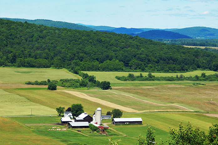
A lush farm along PA Route 706.
Wellsboro is a gateway to this rural region and a popular destination for riders exploring the area. It epitomizes small-town 19th-century America so much so that its streetlamps are still lit by gas. Settled in 1806, it was named in honor of Mary Wells, one of the original settlers. Restaurants, stores, and parks are within walking distance of motels. The first night, I had a tasty dinner at the Steak House Restaurant. Initially, I was a bit anxious about dining solo, but the staff was friendly and welcoming, which is typical of most hinterland Pennsylvanians.
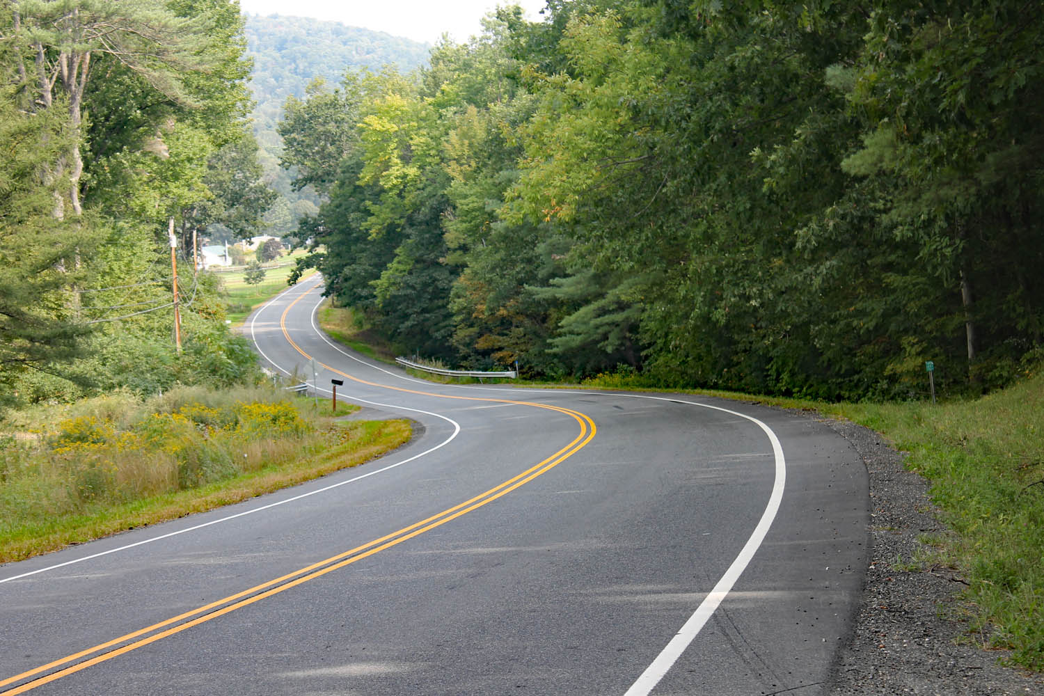
The morning greeted me with a cool but sunny day – perfect riding weather. Firing up my Vulcan, I rolled south on PA Route 287 to PA Route 414 west. Route 414 is one of the prettiest rides in the entire state. This section through part of the Pine Creek Gorge area is rustic, with a few small communities and scattered homes.
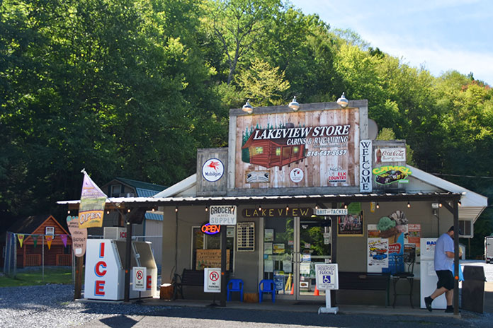
The Lakeview Store near Sinnemahoning State Park on PA Route 872 makes for a perfect snack stop.
Over thousands of years, Pine Creek carved the 47-mile gorge also known as the PA Grand Canyon. The 62-mile Pine Creek Rail Trail is used for hiking, river travel, bicycling, horseback riding, and cross-country skiing. Outside of the wilderness protected area, riders can cruise Route 414 as it slides along for miles next to Pine Creek.
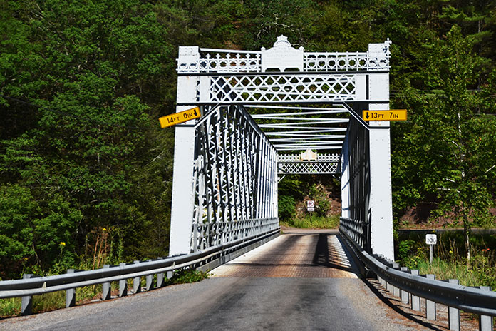
Route 414 through Pine Creek Gorge crosses a one-lane steel-truss bridge.
Parking areas with comfort stations offer river and rail trail access. At the Blackwell Access area, I met a young couple from Maryland who were going to backpack into the surrounding wilderness. We talked a bit, and then I wished them luck and warned them to watch out for the timber rattlesnakes that live in the area. Each June there is an annual rattlesnake roundup festival throughout the region.
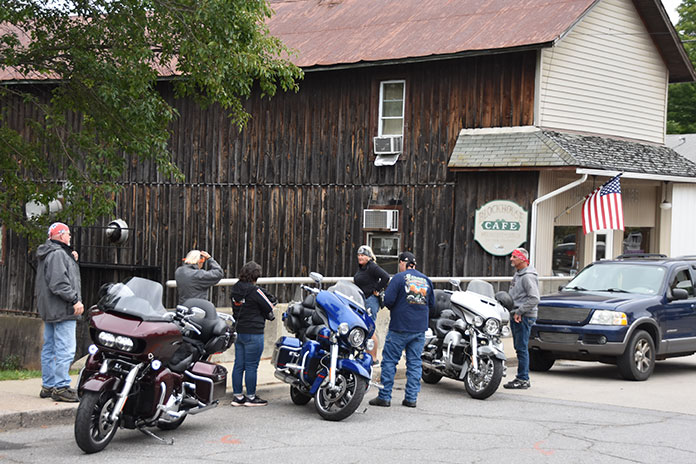
Riders stop at the Blockhouse Cafe.
Continuing my ride, I passed the quaint village of Cedar Run and weaved back and forth on bridges crossing Pine Creek. The roadway crawled up a mountainside presenting a great view. At the intersection with PA Route 44, I roared into the mountains of Tiadaghton State Forest. About 5 miles north of Haneyville, I turned west on Hyner Mountain Road heading toward Hyner Run and Hyner View state parks. With the sun on my face and the sweet mountain air filling my lungs, I was in rider heaven.
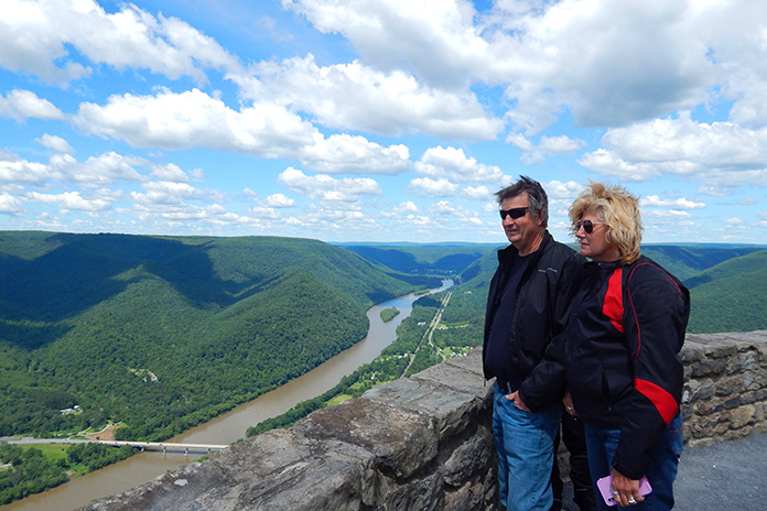
The narrow, winding road to the summit of Hyner View can be challenging, but the views are spectacular. Forested mountains roll toward the sky like a vast green sea, and below, PA Route 120 winds through the valley alongside the West Branch of the Susquehanna River.
Hyner View State Park overlooks the West Branch of the Susquehanna River.
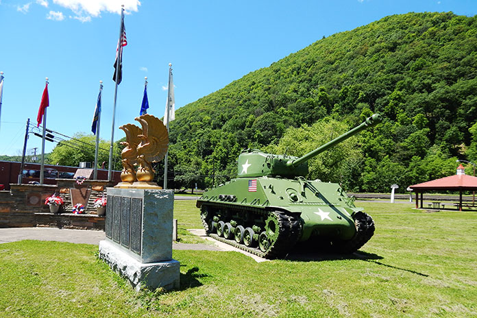
I connected with Route 120 and continued west toward Renovo, once a thriving railroad company town of more than 4,000 people that has dwindled to a population of 1,228. Entering Renovo on Route 120, I stopped at a moving memorial for the soldiers who gave their lives protecting our country. A green battle tank that matches the lush grass and surrounding forest guards the memorial.
A Sherman tank guards Memorial Park off PA Route 120 in Renovo.
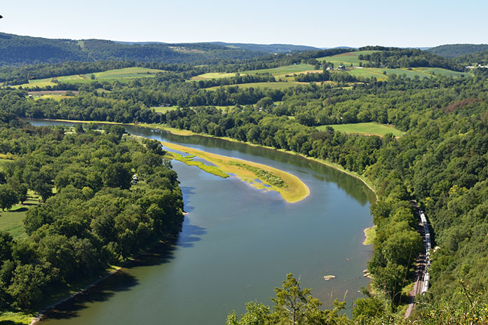
Route 120 heads west alongside the Susquehanna River and the railroad tracks enveloped by thousands of acres of state forests. This route west to Sinnemahoning is beautiful and one of most desolate areas I traveled through. I rode for miles without seeing another soul. It was the first time on the trip that I felt completely alone.
Wyalusing Rocks Overlook on U.S. Route 6 provides expansive views of the Susquehanna River.
People ask if I get lonely or nervous on solo trips, but I actually don’t. Whenever I pulled over for a photo or route check, people often stopped and asked me if I needed help. Sometimes they offered advice on the road conditions or suggested a scenic stop. It reminded me of Blanche Dubois’s line in A Streetcar Named Desire: “I’ve always relied on the kindness of strangers.”
At PA Route 872, I blasted north through Elk State Forest and stopped at George B. Stevenson Dam and Sinnemahong State Park’s wildlife viewing area. Unfortunately, I did not spot any elk. From there, I cruised north out of the mountainous area into lush hills and returned to Route 6 again at Lymansville.
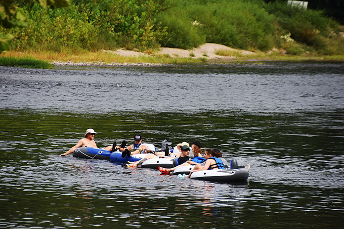
Tubers enjoy the pristine waters of the Delaware River, one of the few major U.S. rivers with no dams.
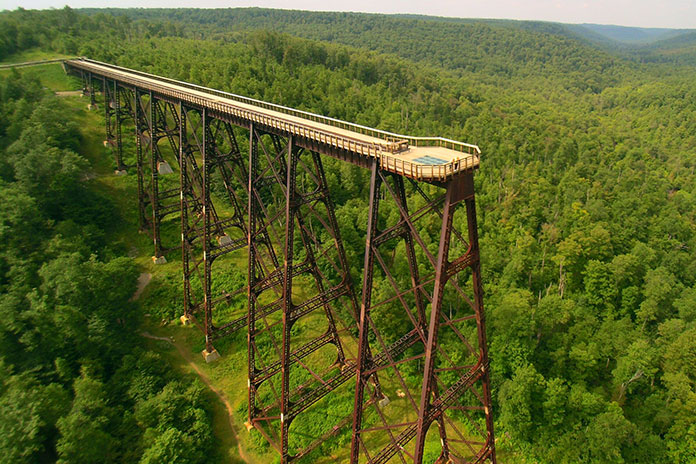
Turning west, I followed Route 6 to Smethport, PA Route 59 west to Ormsby, and then south to Kinzua Bridge State Park, home to the Kinzua Sky Walk. The park’s namesake bridge was once known as the Viaduct, a railroad structure that spanned 2,053 feet across – and 301 feet above – the Kinzua Gorge. Partially destroyed by a tornado in 2003, what remained of the bridge was converted into a pedestrian walkway.
Visitors can now walk 600 feet out on the remaining support towers to enjoy sweeping views of the gorge and surrounding mountains, as well as a glass platform at the end of the walkway for breathtaking views down below. The Kinzua Sky Walk is an especially impressive place to enjoy fall colors.
The 600-foot-long Kinzua Sky Walk at Kinzua Bridge State Park is a popular destination for riders. Alas, motorcycle parking on the bridge is not allowed.
Cruising along Route 6, I made my way back to Wellsboro. There are three recommended stops along the way: Larry’s Sport Center in Galeton, which sells Harley-Davidson, Kawasaki, Yamaha, and Suzuki motorcycles, and the Colton and Leonard Harrison state parks, both of which have impressive views of Pine Creek Canyon.
Back at the Sherwood Motel, I enjoyed a relaxing soak in the warm water of the pool. Afterwards, I had dinner in the lounge of the historic Penn-Wells Hotel, originally built in 1869. Conversing with the bartender and locals, I felt as comfortable as a regular.
The next day, I began my journey home heading south on Route 287 to Morris, but this time I went east on Route 414. And what a great ride it was – weaving and rolling through the countryside, passing farms and surrounded by the green hills on the horizon.
Riders leaving the summit of Hyner View State Park.
Rejoining Route 6 for a spell at Towanda, my Vulcan climbed back up the mountain by the Wyalusing Rocks Overlook, and then I rode PA Routes 409 and 706 through the Endless Mountains region to New Milford.
Somewhere along Route 706, I stopped on a downward sloped shoulder for a photo. As I dismounted, over the bike went. Within minutes, people stopped to help. We righted the bike, I thanked them, and then I continued my ride. I had once again relied on “the kindness of strangers,” and I will pay that kindness forward.
At New Milford, I took a series of pleasantly undulating state routes to Damascus, where I rested and watched Pennsylvanians enjoying the Delaware River. Crossing the bridge into New York, I rolled south on the Upper Delaware Scenic Byway (NY Route 97) toward Port Jervis, which offers expansive views of Pennsylvania and New York.
Along PA Route 872, the author’s Kawasaki Vulcan basks in the beauty of Mother Nature.
As I rumbled back home through New Jersey, I could not help but relive this great Route 6 ride through the Pennsylvania Wilds. I knew the region, its roads, and many other delights would soon be calling me back.
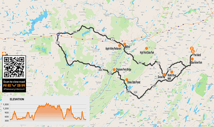
The empty expanses of the rolling, twisty New Jersey County Route 650 beckons riders from the tri-state area and beyond. (Photos by the author)
Greenery, blue skies, and sunshine were bursting forth upon the land like an invitation from Mother Nature to fire up my machine and go forth on a ride on some of my favorite northeastern backroads. I accepted her call and began my cruise a few miles north of the New Jersey border in Pine Island, New York.
Negative depictions of the state in film and television cause some people to think New Jersey is covered in urban sprawl, oil refineries, and clogged “highways jammed with broken heroes on a last chance power drive,” as Bruce Springsteen put it.
Although true for some parts of New Jersey close to the metropolises of New York City and Philadelphia, it’s called the Garden State for a reason. Northwestern New Jersey and northeastern Pennsylvania are blessed with farmland, forests, lakes, rivers, state parks, small towns, country churches, and most importantly, great roads to ride. Those blessings make this loop route a memorable favorite ride.
If you had to guess, would you think this scene was in New Jersey? With farms, forests, and few people, it lives up to the Garden State name.
With the sun warming my face and the sweet fragrance of greenery filling my lungs, I rumbled south on my Kawasaki Vulcan 900 Classic LT. I had sold my heavy Vulcan 1700 Voyager, and although I missed all its bells and whistles, I enjoyed the backroad nimbleness of the much lighter 900.
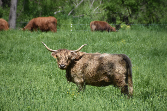
On Glenwood Road (County Road 26) just north of the New Jersey border, the Blue Arrow Farm has an impressive replica of a western Plains Indian village. In New Jersey, Glenwood Road splits, and I turned west onto the rolling, serpentine County Road 565 and stopped at the unique Farm at Glenwood Mountain. Encompassing 170 acres, it sells grass-fed, free-range beef from Scottish Highland cattle, free-range chicken, eggs, turkey, and pork, as well as local honey and organic fruits and vegetables. They also host private farm-to-table dinners and weddings.
A “wooly bully” at the Farm at Glenwood Mountain stares down the author.
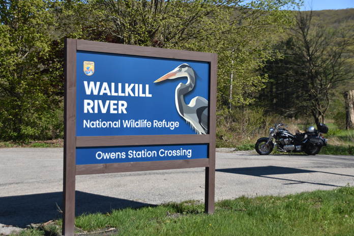
Rolling southwest toward Sussex takes you along the border of Wallkill River National Wildlife Refuge, which runs 9 miles along the Wallkill River (one of the few rivers in the U.S. that flows north) and protects 5,100 acres of land. Wildlife abounds in this area, including waterfowl, raptors, coyotes, deer, and bears. Throughout my years cruising through rural New Jersey, I have been lucky enough to spot several bears, as well as red foxes, a coyote, and numerous great blue herons.
Wallkill National Wildlife Refuge is an ideal place for quiet nature walks.
After crossing over State Route 23, I passed The Village Smith and Cycle Works, a motorcycle repair and blacksmith shop where you can get new tires for your motorcycle and new shoes for your horse. Naturalist writer and gadfly Henry David Thoreau said to “simplify, simplify” your life. In rural New Jersey, we say “diversify, diversify” your life to succeed.
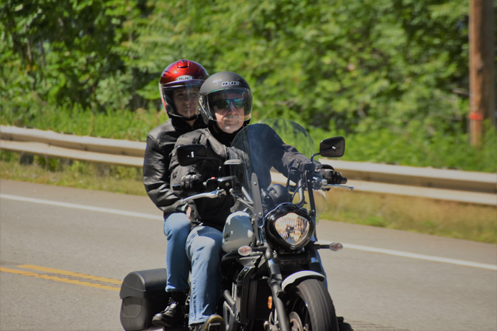
A rider and passenger cruising one of New Jersey’s empty country roads on a spring day.
Continuing on 565 to rustic Plains Road, I connected with U.S. Route 206. Cruising north toward Kittatinny Mountain, I saw some interestingly named eateries, such as Jumboland Diner and Firehouse Bagels, which has a real firetruck as part of its decor.
Passing through part of Stokes State Forest, which encompasses more than 16,000 acres, I turned onto County Route 560, sailing toward the Dingmans Ferry Bridge, one of the few remaining privately owned bridges in the United States.
The author’s Vulcan 900 soaks up some rays in Pennsylvania next to the pristine water of the Delaware River and the Dingmans Ferry Bridge.
Opened in 1900, the bridge is 530 feet long and crosses the Delaware River into Pennsylvania. Riding high above the river on a motorcycle over its wooden planks is quite the experience. This rustic bridge lies within the Delaware Water Gap National Recreation Area, which spans 70,000 acres in Pennsylvania and New Jersey. A boat-launching area next to the crossing has views of the bridge.
Two impressive waterfall areas are nearby: Dingmans Falls and Childs Park. Both are worth a stop. Dingmans Falls is reached by a short, flat stroll on a boardwalk through the forest and alongside the stream. Childs Park is more challenging, with stairs going both up and down and a rugged walkway.
The author’s Vulcan rests proudly on one of the many curving roads that grace this rural ramble through New Jersey and Pennsylvania.
After a brief respite by the river, I fired up my machine and took State Route 739 to Silver Lake Road – a winding, rolling traverse through state forest land, lakes, and hidden gated communities. With areas of huge trees and forests lining the road, you get the feeling of motorcycling through primeval times. Route 402 north is much the same but is a faster-paced ride.
Blooming Grove Road (County Road 4004) and Well Road (CR 434), meander past country stores, rural homes, and forests. I felt like I was riding through a simpler era in America. At U.S. Route 6, a scenic byway that traverses the northern part of Pennsylvania, I roared toward Milford, a touristy town with several good restaurants.
The stone edifice of the St. John Neumann/Good Shepherd Parish stands stoically in the aptly named Lords Valley, Pennsylvania.
After a late lunch at the Apple Valley Restaurant, I cruised across the modern Milford-Montague Toll Bridge with great views of the river back to Jersey. County Route 650 serpentines back through Stokes State Forest, which is a favorite of riders who love to challenge its rolling curves or just cruise along serenely. Traveling Routes 519 and 23 to Sussex, I headed northeast on State Route 284 to Bassetts Bridge Road, Lake Wallkill Road, and Glenwood Mountain Road.
Riders returning from the Pennsylvania/New Jersey hinterlands while appreciating the roadside scenery.
As my Vulcan weaved through the countryside to Routes 565/517 and back to Pine Island, I reflected on what an enjoyable ride it had been. It was one I was destined to repeat.
In early New England graveyards, such as Adams Cemetery in Wilbraham, Massachusetts, grave markers are irreplaceable historical documents that tell stories carved in stone. (Photos by the author)
“You’re riding your motorcycle to find graveyards – on purpose?” The conversation with a young police officer on a road construction detail in western Massachusetts was brief, but it motivated me to share why old graveyards are fascinating places to explore.
Rewind to the 1970s. My dad was a college professor whose academic interests included early New England graveyards. On weekends and summer vacations, he dragged my sisters and me along to find them. Long before GPS, such trips often became a quest since Dad’s approach to navigating involved dead reckoning. “I wonder where that road goes?” he’d say. “One way to find out.” It’s fair to say that Dad informed my interest in exploring on motorcycles.
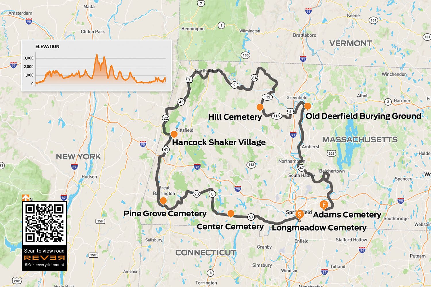
Since Massachusetts has some of America’s oldest communities settled by Europeans, it has some of the country’s oldest graveyards. Three of Dad’s favorites were in the towns of Longmeadow, Deerfield, and Wilbraham, all in the Connecticut River Valley of western Mass. I decide to revisit these graveyards with the benefit of an adult perspective. Since they’re not even 40 miles apart, I extend the ride a couple hundred miles using Dad’s “I wonder where that road goes” approach, and along the way I find other old graveyards to explore.
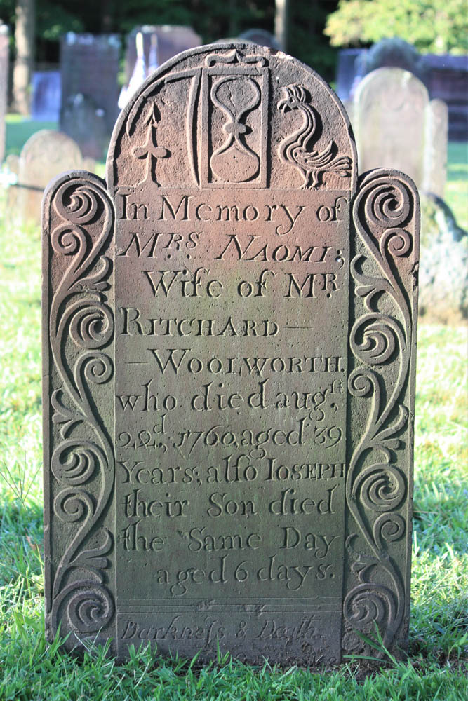
A cut flower signifies death, an hourglass shows time has run out, but a rooster suggests a new dawn.
With eyes looking up and wings, this effigy implies the soul’s flight to heaven.
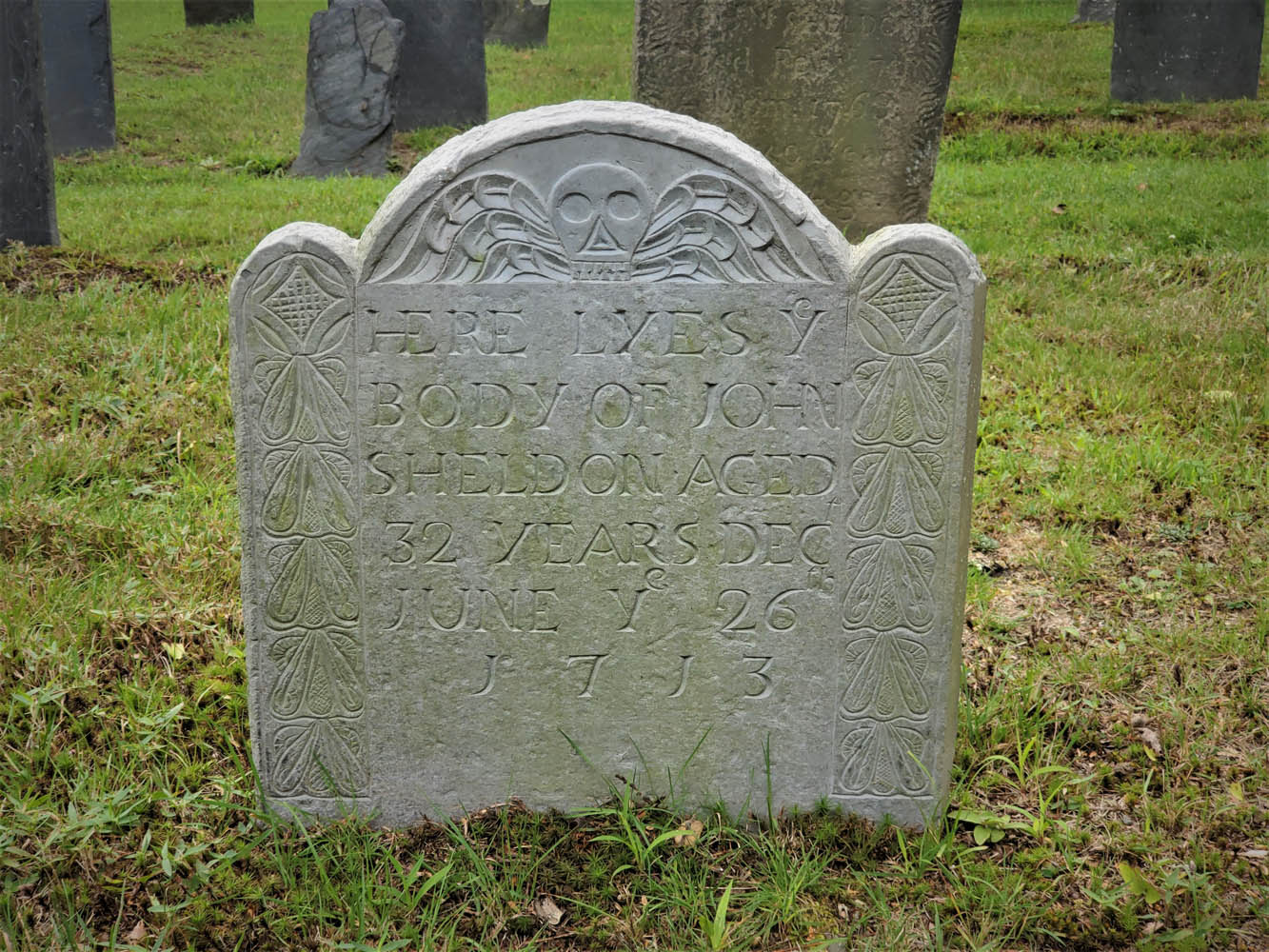
The ride begins in Longmeadow. Along Williams Street, behind historic First Church, is the Olde Burying Ground, c. 1718, a small section within Longmeadow Cemetery. In old graveyards like this, carvings in stone offer insights into family life, social status, occupations, religious beliefs, sickness, tragedy, and the ways people conceived of death.
The Olde Burying Ground, c. 1718, a section of Longmeadow Cemetery, is the town’s oldest burial ground.
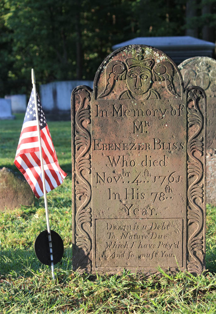
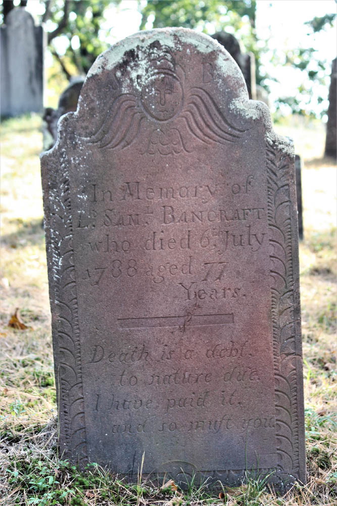
The stone of Ebenezer Bliss concludes with this stark epitaph: “Death is a Debt To Nature Due Which I have Pay’d And so must You.” The nature of one’s death is often explained, such as from smallpox, childbirth, or drowning, although Adjt. Jonathan Burt’s stone leaves us wondering, because he “departed this life in a sudden and surprising manner.”
From Longmeadow, I point my BMW F 750 GS north on U.S. Route 5 across the Connecticut River, then west on State Route 57. To avoid built-up sections of Agawam, I cut through Rising Corner and rejoin 57 past the Southwick fire station. The curves beyond Granville Gorge entice me to quicken the pace, though as I enter the village of Granville a flashing speed limit sign convinces me to roll off.
Center Cemetery, c. 1753, in Granville was located away from the church, a widespread practice at the time.
Up the hill beyond the town hall, I come upon Center Cemetery, c. 1753. As with many old graveyards that are no longer “active” (accepting new burials), one cannot drive into this graveyard, so I park just off the road. Also like many old graveyards, it isn’t next to a church. Some early settlers of New England, notably Puritans, located their dead away from the everyday lives of the living.
The headstone of Lt. Samuel Bancraft, Granville’s first settler, includes a slight variation of the epitaph I saw earlier in Longmeadow: “Death is a debt, to nature due. I have paid it, and so must you.”
This headstone in Center Cemetery includes a variation of an epitaph popular in the era.
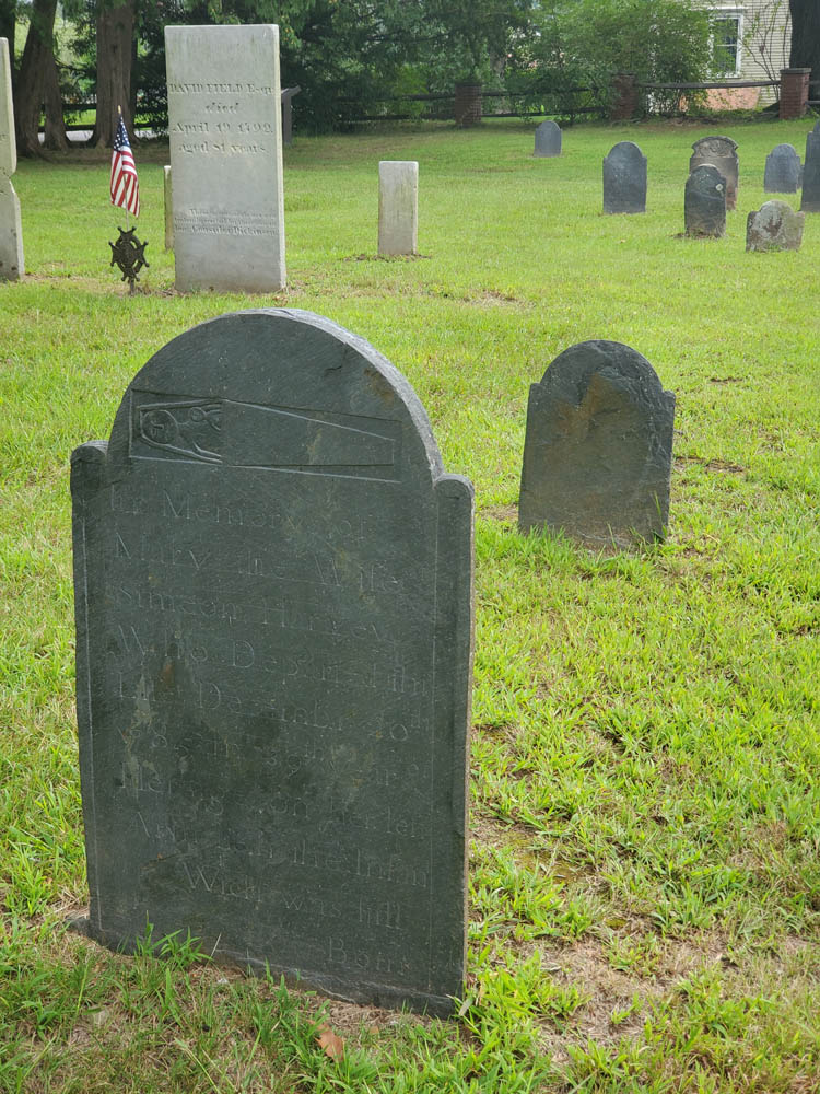
“…on her left Arm lieth the infant Wich was still Born.”
Continuing west, I enjoy several miles of new tar, but on the steep downhill curves to New Boston I am cursing the inventor of tar snakes. Beyond the village, I notice unpaved Beech Plain Road, and a right turn takes me along stands of trees dressed in vibrant yellow fall foliage. There’s not a tar snake in sight.
In Otis, I merge onto State Route 8 north and then lean west onto State Route 23, an entertaining two-lane that hugs the contours of the Berkshire Hills. Past the village of Monterey, I see a sign for River Road. Dad explained that roads of that name are usually curvy and rarely dead end. Right on both counts!
Any dog-loving rider needs to find out where this road goes!
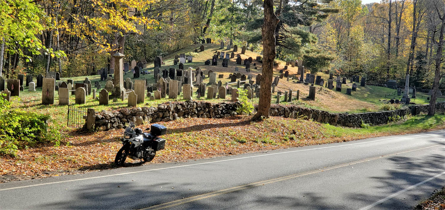
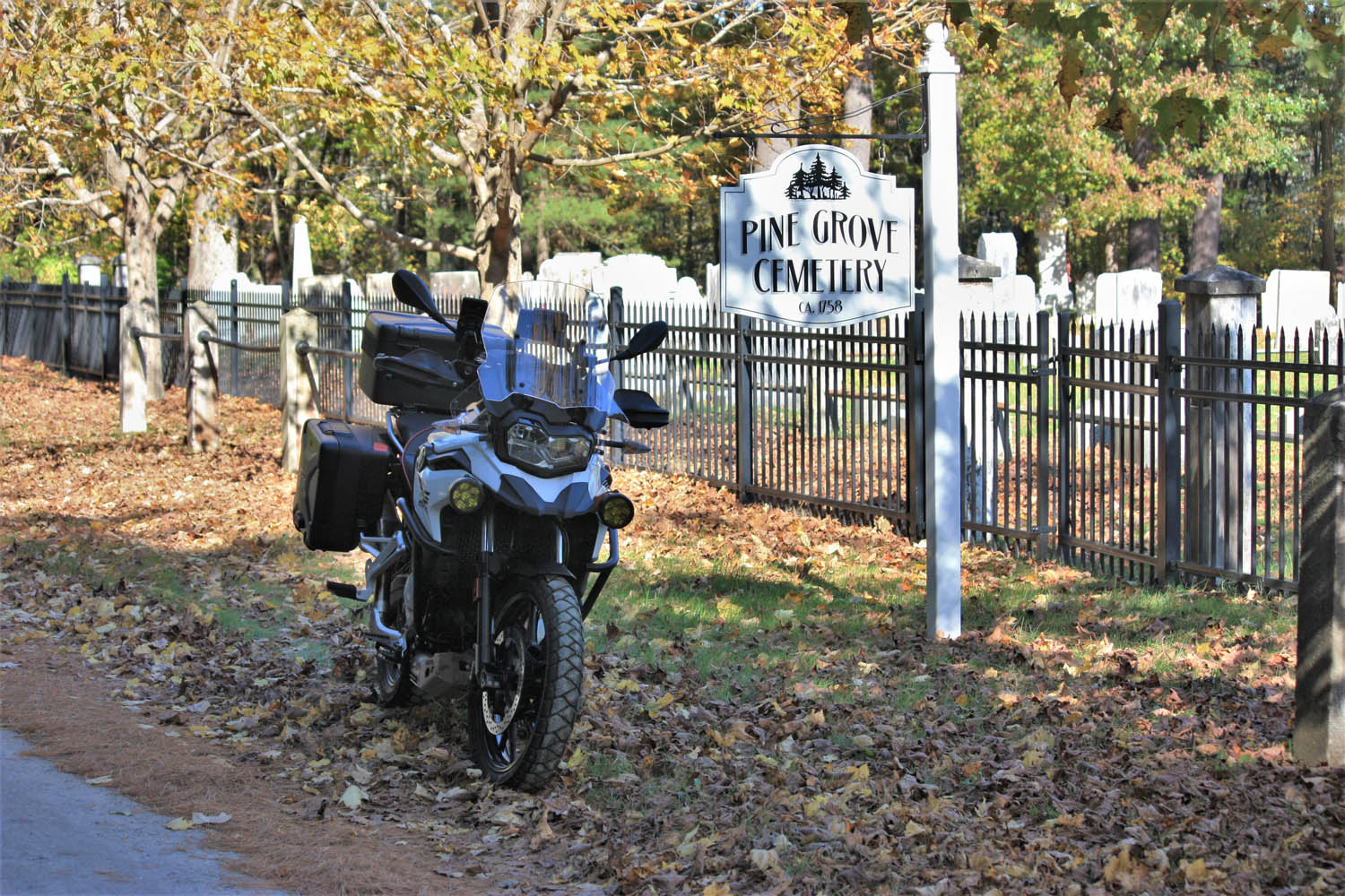
Following a bridge-out detour, I arrive in Sheffield. On the other side of U.S. Route 7 there’s a sign for Bow Wow Road, and being a dog lover, I need to see where it goes. A ways after it turns to dirt, I find Pine Grove Cemetery, c. 1758. I see family plots for Olds and Curtiss and wonder if these graves include ancestors of the automobile and aviation pioneers of those names.
I continue on North Undermountain Road and Pumpkin Hollow Road. At the village of Alford, Center Cemetery, c. 1780, warrants investigation. Among the finds is this pithy epitaph: “Gone not lost.”
Down the road a piece, Bow Wow Road turns to dirt and delivers your humble scribe to Pine Grove Cemetery in Sheffield.
Leaving the town center, West Road gets the nod over East Road, and after a couple turns I’m on State Route 41 riding north through Richmond to Hancock. History buffs can visit Hancock Shaker Village. Shakers were a religious community known for their elegantly functional barns and furniture, and for their devotion to celibacy. (The latter may account for their current lack of numbers.)
Heading west on U.S. Route 20 takes me over the New York border to State Route 22 north and Stephentown. A right on State Route 43 returns me to Massachusetts, having sidestepped Pittsfield’s population center. Another right on Brodie Mountain Road leads to U.S. 7 north. At the five-corners intersection, I turn right onto State Route 43 and follow the Green River to Williamstown, a quintessential New England college town. At the junction of State Route 2, a left leads to lively Spring Street and multiple options for eats and coffee.
In the 18th century, death’s heads began to soften with angel wings and carvings suggesting life everlasting.
Refreshed and re-caffeinated, I head west toward North Adams and know exactly where to go: up the Mount Greylock Scenic Byway. This technical twist-fest leads to the highest point in Massachusetts (3,491 ft). Rockwell Road winds me down the other side of the mountain, and at the Mount Greylock Visitor’s Center, I turn around to ride the route in reverse. This 30-mile round trip is too much fun to pass by.
East of North Adams, the scenic Mohawk Trail (Route 2) rises through the famous Hairpin Turn, on to the town of Florida, then back down through Mohawk Trail State Forest. Exciting curves and elevation changes are enhanced by the clear autumn day. At Charlemont, I go north on State Route 8A, another twisting gem, to Branch Road, which tracks the west branch of North River east to State Route 112. This two-lane path curves quick and easy south to Ashfield where a left on State Route 116 puts me on a favorite twisty two-lane. But first, I stop at Elmer’s, an eatery popular with locals as well as motorcyclists passing through.
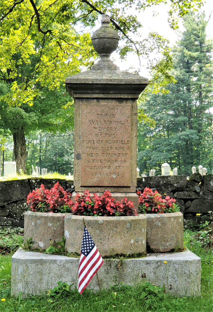
A monument for the War of Nationality, 1861-1865.
While jawing with some old-timers, I learn there’s a “really old” graveyard I should see on Norton Hill Road. As I pull up to Hill Cemetery, I can tell from the styles of gravestones that it’s no older than mid-19th century, but a war memorial right next to the road rewards the stop. Erected in 1867, it includes this wording: “TO THE EVER LIVING MEMORY OF THE SONS OF ASHFIELD WHO DIED FOR THEIR COUNTRY IN THE WAR OF NATIONALITY 1861-1865.” It’s the only place I have seen the U.S. Civil War described using this term.
At Creamery Road, I turn left toward South Ashfield then savor those curves on 116 to South Deerfield. It’s easy to bypass busy U.S. 5 via Lee Road and Mill Village Road to reach the Old Deerfield historic district. There, at the end of Albany Road, is another of Dad’s favorite graveyards, the Old Deerfield Burying Ground, c. 1690s (aka Old Albany Cemetery).
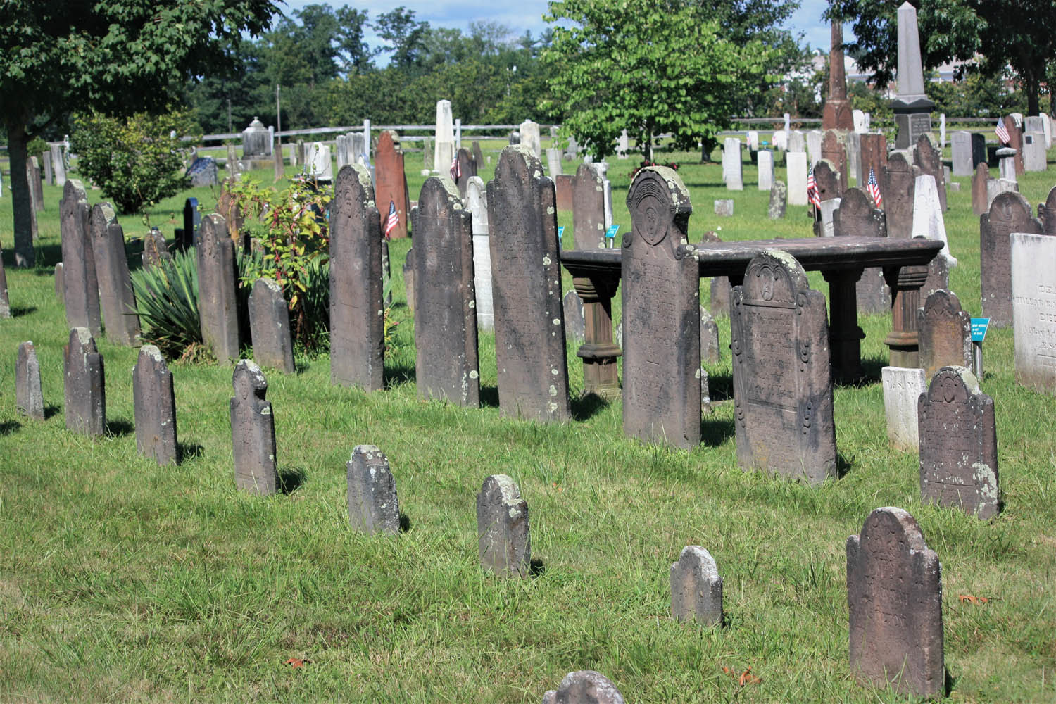
Some old graves, including these at Adams Cemetery in Wilbraham, are marked by both headstones and footstones, carved with complementary designs.
More than a dozen stones date back to the 1600s, the oldest one for Mary Blanchard, who had 10 children with her first husband, John Waite, and nine more with her second husband, John Blanchard. Notably, this graveyard includes a monument to 47 settlers killed during a raid on the town by native residents and their French military allies on February 29, 1704.
Walking the rows of stones, it’s intriguing to note how the styles have evolved over time. Early carvings with skulls gave way to skulls with wings, then winged angels, and then urns with weeping willows. Few parents still give their newborns names like these: Eleazer, Flavia, Zenas, Temperence, Dorcas, Ithamser, Arrethusa, and Thankfull Experience. Also here is a gravestone for a young woman whose name is hard to read without chuckling: Fanny Forward.
Leaving Deerfield, a short stretch north on U.S. 5 connects to another River Road, this one following the Connecticut River south to Mount Sugarloaf. Beyond the bridge, a right onto State Route 47 south follows the river’s other bank where harvested tobacco fields and the Mount Holyoke Range provide scenery.
It’s fitting that Dad is buried in one of the graveyards that so intrigued him.
Keeping to roads less traveled, I make my way through South Hadley, Belchertown, Ludlow, and Wilbraham, to Adams Cemetery, c. 1740. Gravestones here include dozens with epitaphs that speak to the difficulty of life and inevitability of death. Consider two:
“Friends and Physicians could not save, My mortal body from the grave.”
“Youth blooming learn your mortal state, How frail your life, how short the date.”
It’s fitting that Dad is buried here in one of the graveyards that so intrigued him – particularly one that is actively preserved and celebrated as a historical resource. Even if the graveyards in your neck of the woods aren’t as old, it’s likely they’re peaceful, beautiful, and interesting places to explore. When you’re enjoying a ride, take the opportunity to experience history in outdoor museums along the way. Explore old graveyards – on purpose.
Whether you’ve been riding together for years or share the road for just one day, the bond between riders always feels like family. (Photos by the author)
My obsession with the White Mountains and Kancamagus Highway in New Hampshire began nearly a year before I rode the famous route. I’d been testing BMW’s K 1600 B on a late-season ride on Vermont Route 100, just tootling along with all the Subarus, when I saw a guy on the side of the road standing atop an aged custom Harley, waving.
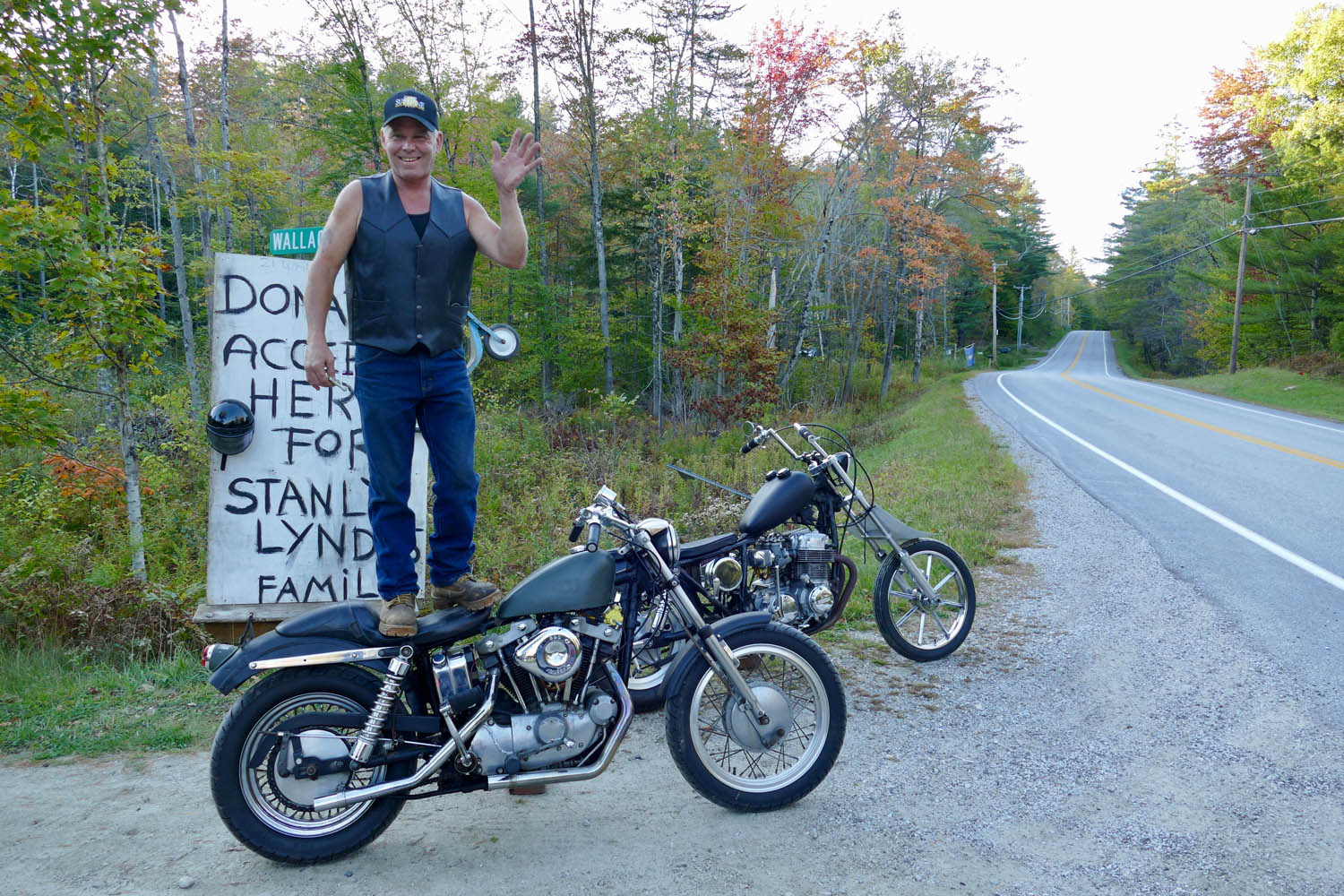
Curiosity got the best of me, so I swung the bagger around to meet Eric, a local mechanic, who said he was standing on his bike to get people to stop and make a donation for a friend and his wife who were in a motorcycle accident.
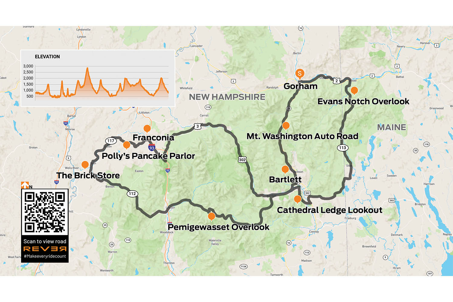
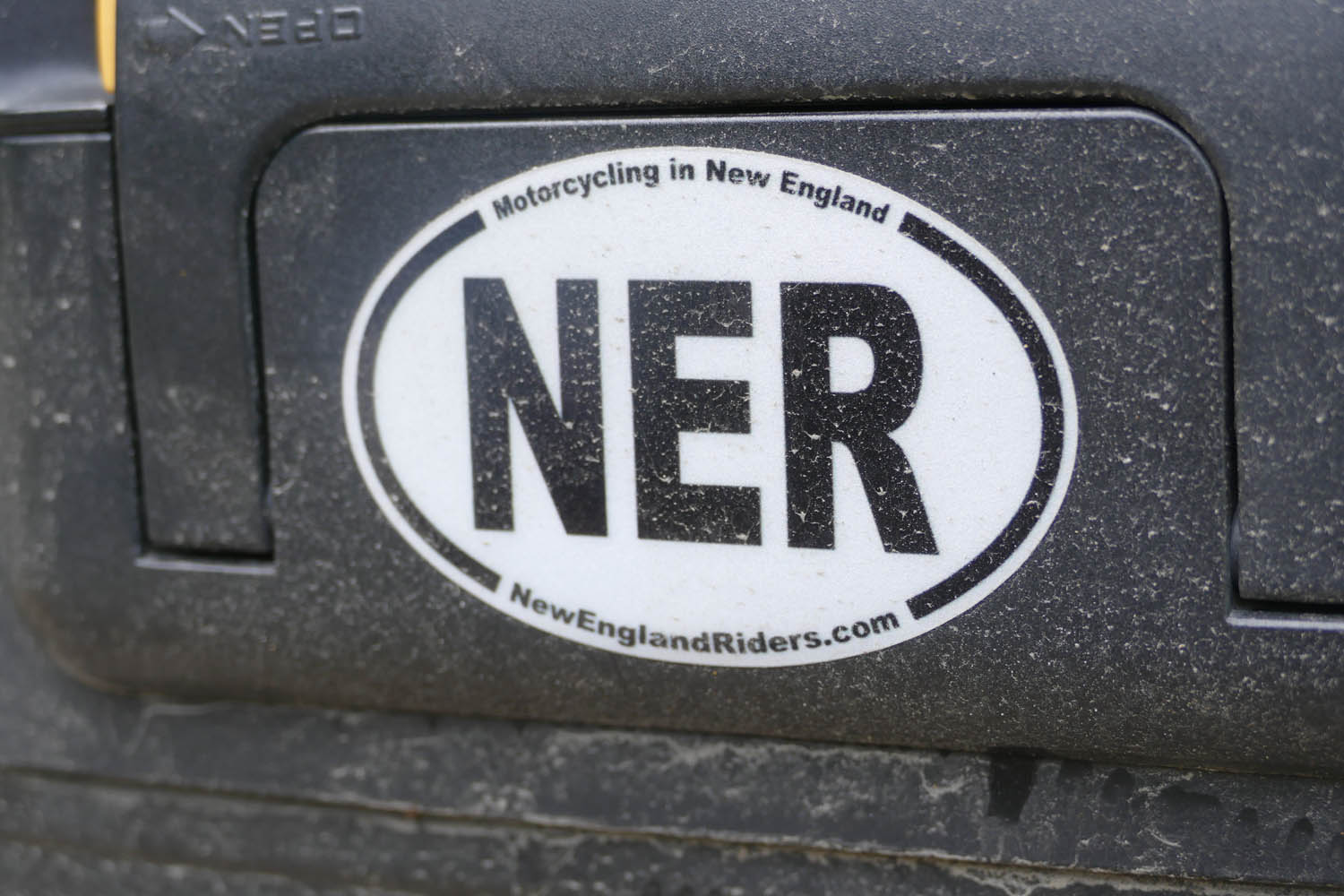
Route courtesy of New England Riders (NewEnglandRiders.org)
This would turn out to be Stanley Lynde and his wife, Laura, owners of Lynde Motorsports in Brattleboro, Vermont. There was an official GoFundMe webpage at the time, but Eric “didn’t do the internet.”
And his method seemed to work, with several people stopping by as we chatted, offering donations and well wishes. Eric, a veteran motorcyclist and builder who can no longer get out for big rides, was very emotional about the situation. When I asked him if there was something I could do beyond a donation, he promptly said yes, I could ride. Specifically, he requested I head up into the White Mountains and ride his favorite road, the Kancamagus Highway, in honor of the Lyndes.
And I tried. With all my heart. But a major storm blew in the next day, the only free day I had before returning the bike and flying home. Eric, his friends, and the road with the odd-sounding name were on my mind all winter long.
A COMMUNITY, NOT A CLUB
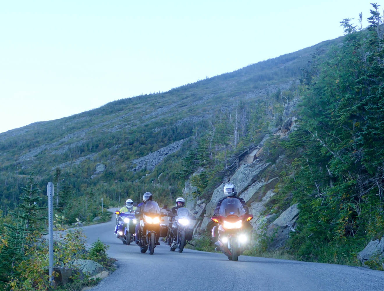
Late the next summer I was finally able to return to the Northeast, this time for a high-mileage test of BMW’s R 1200 RT. The Kancamagus, aka The Kanc (technically NH Route 112), topped my list of roads to explore.
I introduced myself to Eric as he stood on his Harley alongside Vermont’s Route 100. The chance meeting would teach me much about the fellowship of riders, including an induction into the New England Riders (NER) one year later.
I enlisted the help of Ed Conde, route master for New England Riders (NER, newenglandriders.org), an impressively large group (14,000+ strong on Facebook) that identifies as “a community of motorcyclists that self-organize to ride and have fun with other riders,” rather than a club, in which there would be things like dues and rules and officers.
Now, I’m a solo rider by nature, but after getting to know Ed and his wife, Debbie, online, I was excited to meet up with them and a small crew of NER riders to follow Ed’s “Best of the White Mountains” tracks, a 202-mile double loop that launches from Gorham, New Hampshire.
It was a Friday morning in September when I throttled out of Gorham with seven strangers, tracing the Androscoggin River eastward on U.S. Route 2, then crossing into Maine to head south on State Route 113. This rural highway is where the party started, with the road beginning to curve and roll as it swept its way up into the White Mountain National Forest.
Right away, it was clear this group could ride. On the way to the meeting point, I’d been thinking, “Okay, be patient, this could be a long day, be on your guard…” – all the things one should remember when joining an unknown group of riders. When we stopped at Evans Notch overlook for a breather, I learned these NER members are skilled because most had invested in training and trackdays, many under the tutelage of Ken Condon, author of Riding in the Zone.
THE MASTER PLANNER
My new buddies, from left: Ed Conde, Steve Bruning, Mike Woods, yours truly, Bob Blethen, Laura DeAngelis Heinlein, Steve Gallant, Lisa Cheney, and Debra Conde.
The White Mountains, a roughly 90-mile segment of the much larger Appalachian Range, was created by western movement of the North American Plate more than 100 million years ago, long before the glaciers of the Ice Age covered them, then receded, smoothing sharp edges into the rounded notches and dished valleys we see today.
Our group was too early for the region’s famous fall colors, which suited these passionate riders just fine since it meant light traffic as we flowed down State Route 113. At Fryeburg, we followed Ed on a few quick turns to reach Hurricane Mountain Road, a narrow goat path of a backroad that constantly rises and dives, splashing through the densely forested hills, twisting just enough to heighten the senses.
Evans Notch on ME 113 is the easternmost pass in the White Mountains.
I swear I didn’t tell Ed that I’m obsessed with road-trip pancakes; it just happened this group feels the same. Polly’s potential for addiction is real, and I’m happy I live thousands of miles away. Most of us went with pancake “samplers,” where you order three short stacks (yes, per person!), mixing and matching different batters and mix-ins.
It’s at this point I realize Ed Conde is more than just a nice guy with some ideas about good roads. Ed is a purveyor of truly fine roads, the kind of gems you simply wouldn’t find and connect on your own. And as I’ll learn over time, his skills aren’t limited to cataloging premium strands of tarmac; Ed sews in all the best views, bathroom stops, and restaurants, too.
You can see for miles from the Cathedral Ledge overlook, one of many scenic stops on our “Best of the White Mountains” day ride.
It’s the secret stash a local rider might know, but Ed’s not a local here in New Hampshire. He and Debbie live near Boston, and it’s become their shared passion to travel on bikes – he on a Honda ST1300 and she on a Suzuki V-Strom 650 – exploring new states and creating a database of the best motorcycle roads, many of them stitched into day rides. Ed shares these elaborate ride plans and GPX tracks, which span from Nova Scotia all the way down to Alabama and Georgia, on the NER website.
It’s their way of giving back to the community, he says, for all the joy and treasured memories motorcycling has brought to their lives.
TIES THAT BIND
After conquering Hurricane Mountain Road, we traveled west on U.S. Route 302, taking time for a photo stop at the beautiful Cathedral Ledge viewpoint in Echo Lake State Park, before continuing to Bear Notch Road, another curvy delight with three worthy overlooks.
Road-trip pancake eating is one of life’s greatest pleasures, so a stop at Polly’s Pancake Parlor was more than welcome. Polly’s started serving the tasty cakes in Sugar Hill, New Hampshire, back in 1938 as a way to highlight their maple products. The maple spread is insanely delicious. Photo by Ed Conde.
Then finally, up ahead, the road sign I’d been envisioning for almost a year: State Route 112, the famous Kancamagus.
While no one I was with that day knew the reason behind my request to ride this particular highway, I was sure they would feel equally compelled by Eric standing on his old Harley, feeling helpless about his friend’s fate.
Since that chance meeting, I’d learned Laura had survived her injuries, but sadly, Stanley had not. I carried his family in my heart as I rolled onto the Kanc.
PANCAKES FOR LUNCH
Just as Eric promised, the views from Route 112 were glorious. The highway is well-kept and curvaceous, chasing after the Swift River like a blackbird mobbing a hawk.
When we stopped at the Pemigewasset Overlook, everyone was in great spirits, laughing and telling stories. I didn’t even stop to wonder how it was these strangers I’d met only hours before now felt like old friends. We’ve all felt it, that current of shared experience that so instantly connects riders when and wherever we meet.
The NER group I rode with were on a variety of bikes, but the flavor du jour was definitely sport-tourer.
Unexpectedly, the ride only continued to get better as the day rolled on. Departing the Kanc, we reunited with Route 302 and headed east to Bath, where you’ll find The Brick Store, America’s oldest continuously run general store. The market is flanked by a popular ice cream shop, but we were headed for Polly’s Pancake Parlor on Route 117 for an afternoon feast of hotcakes and bacon.
From Polly’s we headed east to Franconia and followed U.S. Routes 3 and 302 to link together alpine lakes and waterfalls, crossing over our westbound route around Bartlett. There’s plenty to see and do on this section, but we kept an eager clip so we could start up the Mount Washington Auto Road, the capper of Ed’s “Best of the White Mountains” ride, well before the toll road’s cutoff entry time of 5 p.m.
A SLICE OF HEAVEN
Mount Washington (6,288 ft) is the most prominent peak west of the Mississippi and the highest mountain in the Northeast, but what’s really neat about it is the road that takes you to the summit. It’s just 7.6 miles long, but man, the views are forever. The drop-offs are too, which can rattle some, even though the mountain is well controlled by low speed limits and heavy traffic.
We arrived at the summit with just enough time to check out the museum and observation areas. This windy peak was also where I said goodbye to my new friends, since we’d head in different directions at the mountain’s base.
Those smiles on my and Lisa Cheney’s face sum up the feeling of riding up the Mount Washington Auto Road (photo by Steve Bruning). A sign at the bottom of the 7.6-mile road reads: “If you have a fear of heights, you may not appreciate this driving experience.” Riding makes it even more of a thrill.
After snapping an action shot or two of the group halfway down the now heavily shaded northeastern slope of the mountain, park trucks pulled up, urging stragglers like me toward the gates. On a whim I asked if I could ride back up – “super quick” – to get a photo of the empty road.
I was floored when the guys said sure, I could have the 20 minutes or so it would take them to usher the remaining tourists from the lower lookout points.
And so began one of the most striking experiences of my 36 years of riding. I had the top half of Mount Washington to myself. Its Auto Road, which had been clogged an hour before, was now empty.
And I’m proud to say I didn’t rip up and down the famous toll road as I would’ve in the past. Instead, I focused every bit of energy on soaking up a scene that looked and felt like a literal slice of heaven.
By this point, my White Mountains ride had become way more than a report about a day trip in New England. It reminded me that I’m part of a huge, ever-present family. Showed me that true friends can be old, or new, or only in your heart.
No matter how far we wander, there will be other riders to make us feel at home.
A few years ago, Rider published my article about riding Vermont Route 100 from south to north, ending at the Haskell Free Library and Opera House, which straddles the U.S./Canada border. Someone wrote a letter to the editor asking how I got back. U.S. Route 5 runs along the east side of Vermont, and it happens to be another one of my favorite rides. It has all the elements of a great motorcycle road: beautiful scenery, fine curves, light traffic, and nice places to stop along the way. For this ride, I am again starting at the Massachusetts border and heading north, but it can also be run in reverse.
I cross from Massachusetts into Vermont just south of Guilford, and the road almost immediately plunges into the woods, curling back and forth around the trees, a preview of what’s to come. First, I pass through Brattleboro. With 12,000 residents, it’s the largest town I’ll encounter today. Downtown consists of about three blocks of century-old brick buildings. It’s a little congested, but as soon as I clear the roundabout at the junction with State Route 9, everything eases up and I’m into rural Vermont in search of coffee.
Just one of the many wonderful curves on U.S. Route 5.
Putney General Store bills itself as Vermont’s oldest general store. It has creaky floors, good food, and – most importantly – good coffee. Properly caffeinated, I’m on my way, and U.S. 5 reveals its true character: rising, falling, and curving through the landscape. I lose myself in its rhythm.
These petroglyphs are believed to have been carved by the Abenaki hundreds of years ago.
In Bellows Falls, the falls don’t bellow anymore. The river was dammed in 1802 to aid with upstream navigation. Down near the river, a mysterious row of faces is carved into the rocks. The petroglyphs are believed to have been carved by the Abenaki hundreds of years ago. Curiously, a couple of the faces appear to have antennae. Evidence of an extraterrestrial visit? I ponder the question as I head out of town.
The Cornish-Windsor Covered Bridge is the longest two-span covered bridge in the world.
U.S. 5 resumes its swooping, twisting, and turning as it tunnels through the trees. Nothing is too tight or unexpected, just a wonderful ride, and I drink it all in. There is a zig and a zag in Springfield before the enjoyment continues to the American Precision Museum in Windsor. It’s housed in the Robbins and Lawrence Armory, where they developed the concept of interchangeable parts in the 1840s. One display in the museum is a belt-driven machine that turns gunstocks. As the blank for the stock spins, the cutters gracefully move in and out. The accompanying video is mesmerizing. In addition to many machine tools, they also have Bridgeport milling machine serial number 001 – if you’re a gearhead, you’ll understand its significance.
The American Precision Museum houses tools from the birthplace of modern manufacturing.
Past Windsor, the road resumes its rhythm as it carves up around a golf course. All along the way, I pass small farms with their quintessential red barns. Some have stands selling fresh veggies, and I pick up some tomatoes and sweet corn.
White River Junction, where the White River joins the Connecticut, has long been a transportation hub. The arrival of the railroad in the 19th century cemented its status. Today, it’s at the junction of Interstates 89 and 91 as well as U.S. Routes 4 and 5. All the amenities are near the highway interchange, and it’s easy to miss downtown, but with several restaurants to choose from, it’s a great spot for lunch.
One of the many small farms along U.S. 5.
A sign in the window at Dan & Whit’s General Store in Norwich declares, “If we don’t have it, you don’t need it!” Whether you are looking for an alarm clock or beer pong supplies, they have it. The paint department? It’s in a room behind the deli. Keep going and you’ll find a huge hardware section. The variety of stuff crammed into the space is remarkable, and it’s easy to get lost among the hams and hammers and hammocks.
Leaving Norwich, there is a change. The hurry is gone, and I glide effortlessly around the curves, passing by narrow valley farms and through the villages of Thetford, Fairlee, Bradford, Newbury, and Wells River. In Barnet, there is another perceptible change as U.S. 5 parts ways with the Connecticut River and starts following the smaller Passumpsic River. The curves are tighter, the hills are closer, and at one point, U.S. 5 slips between the northbound and southbound lanes of I-91 for a bit.
There is a “North Country” feel here close to the border.
In St. Johnsbury, State Route 5A splits off as it passes the St. Johnsbury Athenaeum and the Fairbanks Museum & Planetarium. Both 19th-century edifices were built by the Fairbanks family. Their Fairbanks Scales Company changed how commerce was done, and the family spent much of their fortune locally. Fine Victorian architecture lines both sides of the road here.
After Lyndonville, U.S. 5 cuts through the landscape to West Burke, where I follow State Route 5A toward Lake Willoughby. The lake is the crown jewel of this ride. Nestled between Mount Pisgah and Mount Hor, it resembles a Norwegian fjord. The road runs up the east side, perched precariously between lake and ledge.
With the border just ahead, it’s time to turn around.
Past Lake Willoughby, there is a “North Country” feel. The rivers flow north toward the St. Lawrence River, the landscape is more open, and the trees seem shorter. Route 5A reconnects with U.S. 5 in Derby Center and heads for the Canadian border at Derby Line. There, within sight of the Haskell Free Library and Opera House, not far from the border, is a sign that declares “End 5.” Just beyond is Quebec and a large sign that says “Bonjour.” It’s time to head back. Maybe I’ll take Route 100.