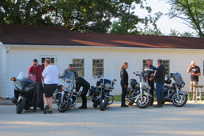
The Route 66 Interpretive Center, one of several interesting stops on this Route 66 motorcycle ride, uses audio-visual exhibits to immerse visitors in the history of the Mother Road. The building was built in 1937 and served as an armory until 1971. Photos by the author and Steve Skinner.
U.S. Route 66 was established in 1926 and was billed as the shortest, fastest, and most scenic all-weather route connecting Chicago, St. Louis, and Los Angeles. Dubbed the “Mother Road” by John Steinbeck in his novel The Grapes of Wrath, Route 66 was used in the 1930s by migrants fleeing the Dust Bowl in search of a better life out West. During World War II, it facilitated the movement of troops and equipment. And during the post-war economic boom of the 1950s and 1960s, Route 66 became indelibly linked to the Great American Road Trip.
My home state of Oklahoma boasts about 400 miles of the historic highway – the most of any of the eight states touched by Route 66. The Mother Road played a central role in my budding love affair with riding. In 1977, at the age of 14, I rode a 100cc 2-stroke Kawasaki along one of the best stretches of Route 66 in the state – the 100 miles between Oklahoma City and Tulsa. The 200-mile round trip was my first long motorcycle journey. It took me all day and cost about $2 in gas, and my long-suffering parents had no idea what I was up to.
Forty-six years after that formative adventure, I retraced my route, only this time I allowed time to take in the roadside attractions and small-town charms that make Route 66 such an iconic piece of Americana. Once again, I felt right at home on the Mother Road.
Not far from my home, I hopped on Route 66 at its junction with Interstate 35 in Edmond. I headed east through wooded terrain and past sprawling Arcadia Lake before stopping at the Arcadia Round Barn. Listed in the National Register of Historic Places, it was built in 1898 by a local farmer who thought its round design would make it tornado-proof. Science may not support that belief, but the Round Barn has survived in the middle of Tornado Alley for 126 years. It’s now a museum, gift shop, and live music venue.
The Arcadia Round Barn, built in 1898, was designed to be tornado-proof and still stands in the heart of Tornado Alley.
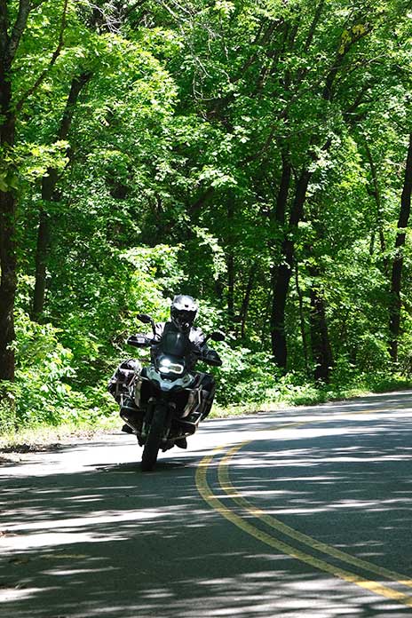
Continuing east, the countryside along this stretch is a mix of woods, farmland, and grazing pasture. Although not the transcontinental artery it once was, Route 66 remains important to the communities it passes through. The tarmac is mostly in great shape, and the occasional sweeping turns are enough to get you off the center of your tires.
In Wellston, I stopped at The Butcher BBQ Stand, one of the best barbecue restaurants around. The award-winning flavors were developed during eight years on the competitive barbecue circuit, including more than 400 1st-place finishes. One of my riding buddies calls this barbecue “meat candy,” and he’s not wrong. Thirty minutes before The Butcher opened, the line was already out the door.
The Butcher BBQ Stand offers award-winning smoked meats on Route 66 near Wellston.
Just a few miles down the road in Warwick is the Seaba Station Motorcycle Museum, which was originally a Route 66 service station named after the proprietor back in the 1920s. The building was purchased in 2007 by Jerry Reis, and he opened the museum in 2010. It’s not only a great place to see a bunch of classic motorcycles, but it also has great Route 66 swag.
Seaba Station in Warwick has an impressive collection of vintage bikes and memorabilia as well as a great gift shop for some Mother Road swag.
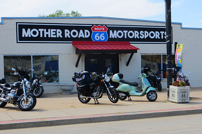
I next headed east-northeast toward the town of Chandler, where roadside attractions include the Route 66 Interpretive Center and Route 66 Bowl, a bowling alley with dozens of authentic vintage oil company signs lining the parking lot.
Route 66 Bowl in Chandler with its collection of authentic oil company signs is one of the many Mother Road landmarks to visit on this ride.
Another 14 miles up the road, we stopped for lunch in Stroud at the Rock Cafe, another Route 66 institution. Opened in 1939, it’s named after the local sandstone used in its construction, and over the years it has been a trusted stop for long-haul truckers, a high school watering hole, and even a makeshift Greyhound bus station for soldiers shipping out during World War II. Pixar executives made stops at the cafe when developing the hit movie Cars and based the character “Sally Carrera” on proprietor Dawn Welch. The burger I had there was outstanding – and it was cooked on “Betsy,” the original 1939 grill.
The iconic Rock Cafe in Stroud gets its name from the sandstone used for its construction in 1939. The delicious food served up there is still cooked on the restaurant’s original 85-year-old grill, “Betsy.”
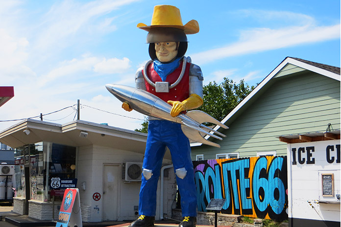
The final stop on my Mother Road reunion tour was Buck Atom’s Cosmic Curios on Route 66 in Tulsa to see “Muffler Man” Buck Atom, Space Cowboy. Few authentic Muffler Men – giant statues used by businesses for eye-catching advertising – remain. Buck Atom was created using a mold from a salvaged 1960s Muffler Man cowboy. Christened in 2019, Buck is 20 feet tall, and he now holds a silver rocket instead of a muffler. He stands guard over a gift shop at the site of an old Route 66 gas station in the heart of Tulsa. The new, old-time Muffler Man fits right in on the Mother Road.
A reimagined Muffler Man stands tall at Buck Atom’s Cosmic Curios in Tulsa.
Headed back to my home in Oklahoma City with daylight fading fast, I hopped on the interstate to make time – the very interstate that marked the end of Route 66’s prominence in Oklahoma, bypassing many of the communities stitched together by the Mother Road. True, the ride home was faster, but it was far less interesting. Just like during my first highway riding adventure back in 1977, I’m more at home on the Mother Road.
Tim DeGiusti lives and works in Oklahoma City, Oklahoma. Tim returned to motorcycling in 2012 after a long break, and since has ridden throughout Oklahoma and 38 other states (and counting).
John Alger rides the historic U.S. Route 66 from Chicago, Illinois, to Amarillo, Texas, on his kickstart-only 1978 Yamaha SR500.
Dubbed the “Mother Road” by John Steinbeck in The Grapes of Wrath and known as “Main Street USA,” U.S. Route 66 will celebrate its 100th anniversary in 2026. No other road in America had such an impact on growth, migration, transportation, and popular culture. During the Great Depression and the horrific Dust Bowl of the 1930s, Route 66 was a paved pathway to a better life, transporting tens of thousands of people from the heartland to the West.
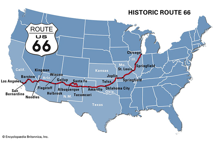
Map of Route 66 courtesy of Encyclopedia Brytannica
Right after WWII, my Uncle Don traveled from California to his hometown of Springfield, Illinois, using much of Route 66 and riding a kickstart, air-cooled, single-cylinder AJS. As I pondered my own journey on the Mother Road, it seemed fitting to attempt it on my 1978 Yamaha SR500, which is also an air-cooled, kickstart Single. Over the years, I have owned several Yamahas, but the SR500 has been my preferred ride for its light weight, effortless cornering ability, competent disc brakes, and simple but elegant design. I like it so much, I own two.
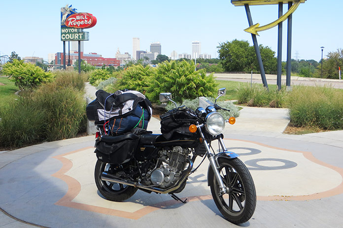
The author’s 1978 Yamaha SR500 on Route 66 in Tulsa, Oklahoma.
For my trip, I chose the one with 30,000 miles on the odometer. Except for upgraded brake hoses, it was bone stock. To get it ready for my Route 66 adventure, I gave it a complete engine and chassis overhaul, as well as a 535cc big bore kit, an oil cooler, and a SuperTrapp exhaust. I retained the stock air box and K&N air filter but re-jetted it as required. The new chain and sprockets were one tooth larger on the countershaft, which lowered cruising rpms and resulted in a mostly vibration-free ride.
The SR500 also has a no-frills CDI ignition system with a strong charging system, allowing me to keep my cellphone and Bluetooth full of juice, and a centerstand, a must-have for daily chain lubrication and fixing flat tires (I had one).
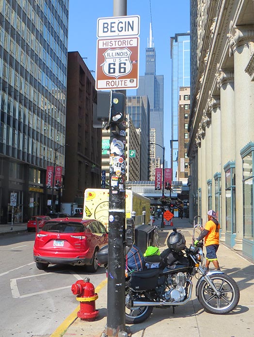
U.S. Route 66 begins in Chicago, Illinois, within sight of the Willis Tower (formerly the Sears Tower).
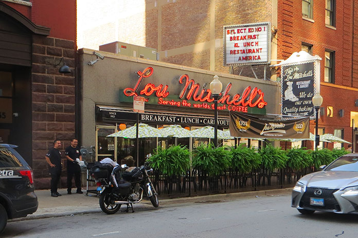
Since Route 66 starts in Chicago, I transported my bike from my hometown of Merritt Island, Florida, in my Chevy van. The first day of riding started in Chicago rush-hour traffic on the Kennedy Expressway, which was undergoing road construction, but after stop-and-go for two hours in record heat, I was rewarded with the U.S. 66 “Begin” sign at the corner of Adams Street and Michigan Avenue across from The Art Institute of Chicago. Just a few blocks away is the Willis Tower (formerly the Sears Tower), and a few blocks farther is the famous Lou Mitchell’s restaurant, which is over 100 years old and served a great breakfast to start my trip.
Lou Mitchell’s is a legendary eatery in downtown Chicago.
Aside from the sweltering temperatures and humidity of August, Chicago’s beautiful residential areas and parks made the short trip to the suburbs quite pleasant. The first 100 miles of Route 66 is known as the Heritage Corridor, which also includes towns along the Illinois & Michigan Canal, which connected Lake Michigan to the Illinois River, and Starved Rock State Park. In Cicero, I stopped to see one of Al Capone’s houses. In Berwyn, I checked out the world’s largest laundromat, which is over 13,000 square feet and even has a bird aviary, and I also passed by one of the oldest-operating White Castle restaurants.
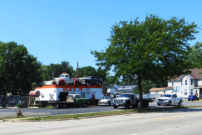
Dick’s on 66 is located in Joliet, Illinois.
Traveling south, I found a neat roadside display in the town of Joliet called Dick’s on 66, an old towing shop decorated with several vintage vehicles and a patch of bricks purportedly from the original Route 66. Across the street is a restored gas pump and ice-cream shop. Joliet is also the home of the state prison and was featured in the 1980 movie The Blues Brothers.
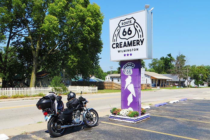
In Wilmington, Illinois, I cooled down with a sundae at the Route 66 Creamery and spotted the first of five “giants” I would see on my trip: a Sinclair dinosaur on the roof of G&D Tire Company.
Route 66 Creamery is in Wilmington, Illinois.
For this trip, I tried to take the oldest sections possible of Route 66, and Illinois had them clearly marked. Some sections of road looked more like abandoned driveways, with weeds growing through cracks in the concrete. My little SR500 was perfect for this kind of duty.
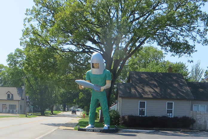
One of the few remaining Muffler Men is located in Wilmington, Illinois. The bright green Gemini Giant holds a silver rocket and was named in honor of the Gemini space program of the 1960s.
In Towanda is Dead Man’s Curve, a sharp curve that caught many drivers unaware and was the site of numerous accidents from the 1920s to the 1950s. There’s even a preserved series of Burma Shave signs that say: Around the curve / lickety-split / beautiful car / wasn’t it? I had a 25-plus mph headwind for most of that first day, and it felt as if I was riding into a blow drier. My first night was spent at the Ghost Hollow Lodge in Chandlerville, Illinois, where I fortified myself with a dinner of venison and fresh veggies.
On the second day, I stopped in Springfield to cool down with an iced tea at Route 66 Motorheads Bar & Grill, which also has a museum and gaming room. Just south of Springfield in Carlinville, my fun was interrupted by a flat tire. I had packed tools, tire irons, a portable compressor, and a tube patch kit, but my tube was too badly mangled by the nail. Scott McDaniels of S&S ATV came to the rescue by delivering a new tube (at no charge), a local resident across the street brought me ice water, and the local city hall allowed me to do the work on the north side of their office in the shade on the concrete. It just goes to show how kind strangers can be when you are in a bind.
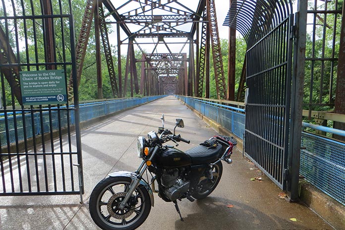
The Old Chain of Rocks Bridge is located in Granite City, Illinois.
The repair set me back almost four hours, and I had to bypass many of the Route 66 sights from Carlinville to St. Charles, Missouri, where I stayed with friends. The following day, I unloaded my luggage and backtracked to Granite City, Illinois, to see the Old Chain of Rocks Bridge. The mile-long bridge was part of the original Route 66 from 1936 to 1965 and allowed motor vehicles to cross the Mississippi River from Illinois to Missouri. It features a 30-degree turn partway through. I had gone over this bridge in a car as a kid before it was decommissioned in 1968. It is now only open to foot traffic and bicycles.
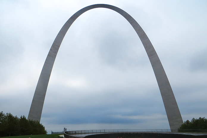
The 630-foot Gateway Arch in St. Louis, Missouri, was completed in 1965.
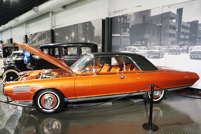
While in St. Louis, I also went up into the 630-foot Gateway Arch, which was completed in 1965. It is now part of the National Park Service, and with recent remodeling and upgrades, it’s a not-to-miss experience. I also visited the National Museum of Transportation on the west side of St. Louis. This may be one of the best transportation museums in the country and has the only remaining GM Aerotrains. It also has a running Chrysler Turbine Car like the one at the Henry Ford Museum in Michigan.
A Chrysler Turbine Car at the National Museum of Transportation in St. Louis.
After getting my luggage loaded back on the SR500, my next stop was Times Beach, Missouri. Route 66 used to cross the Meramec River there, and the remnants of the bridge are still there, along with a Route 66 State Park. I met some folks from Europe riding Route 66 on rented Harleys, and they were aghast that I was attempting to make the same trip on my antique bike with no GPS navigation and only an EZ66 guide in my tankbag.
Remnants of the Route 66 bridge in Times Beach, Missouri.
Times Beach was the site of the second largest EPA Superfund site due to a local contractor spraying dioxin on the dirt roads for dust control. All the buildings were bought by the EPA and leveled, and it’s currently considered a ghost town. West of Times Beach is the Meramec Caverns, where I ran into my new European friends again. My bike would do roughly 100 miles per tank of fuel, which coincided with my body’s need to stand up and stretch out a bit and suck down a cold beverage.
A group of Europeans riding Route 66 on rented Harleys stopped at the Route Route 66 State Park in Missouri.
I stayed at the KOA in Springfield, Missouri, that night and rented a cabin. I had planned on renting a primitive campsite, but for only about $40 more, I got an air-conditioned cabin, lights, electricity, a mattress, a table, and a TV. It was a bargain!
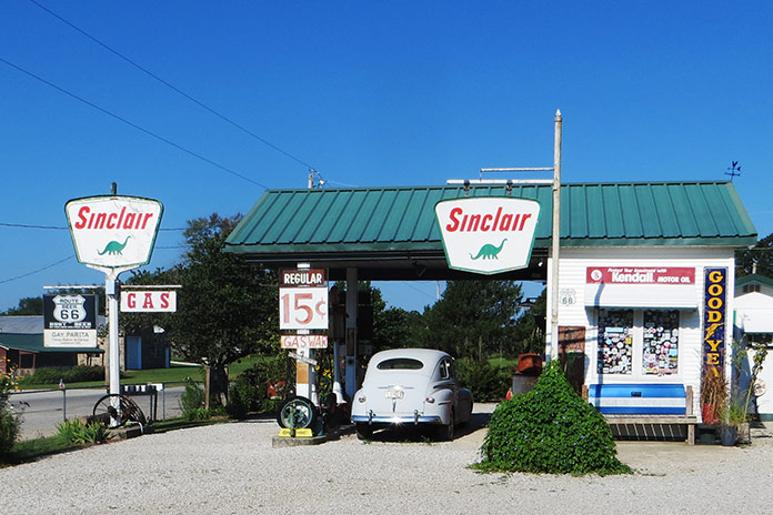
Along the way in Missouri are a few museums and stops such as a replica 1930s Sinclair station called Gary’s Gay Parita in Ash Grove, Missouri, where the sign reads “Gas Wars” and advertises fuel at 15 cents per gallon. Another sign reads “Kendal, your 2,000 mile oil!” We have certainly come a long way!
A replica 1930s Sinclair gas station called Gary’s Gay Parita in Ash Grove, Missouri.
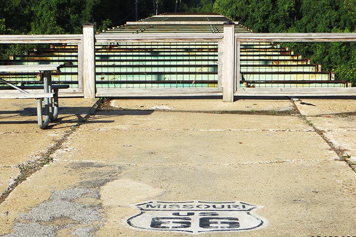
Shortly after the Sinclair station on the Old Route 66 trail, I crossed an old truss bridge that crossed over Johnson Creek in Spencer, Missouri. Like the old sections of Route 66 in Illinois, this section looked like an abandoned road going into the backwoods. It was beautiful.
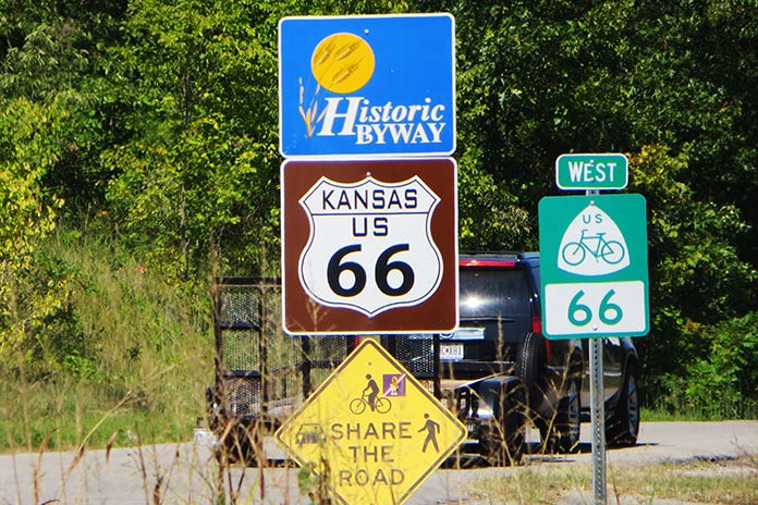
Only 13 miles of Route 66 pass through Kansas.
Kansas only has a very short 13-mile section of the Old Route 66 path, and if you take that, you are blessed with crossing one of the few remaining Marsh Arch bridges left in the country – and the only remaining one on Route 66, this one having been built in the early 1900s.
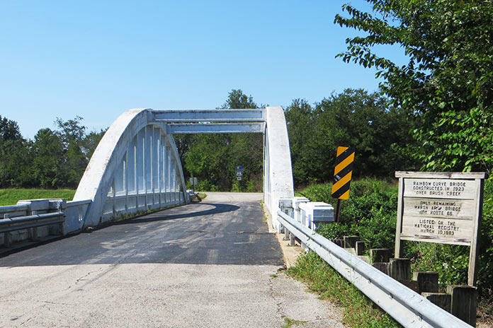
The Rainbow Curve Bridge was built in 1923. It’s the only remaining Marsh Arch bridge on Route 66.
Oklahoma likely has the most Route 66 sites of any state. After the road was decommissioned by the federal government for use as a federal highway, Oklahoma named it State Road 66. It’s easy to follow, although I did manage to miss a sign and ride maybe 50 miles off course. The best Route 66 Museum is in Clinton, Oklahoma. It covers the initial planning and construction of the route, along with different scenes of Americana, a video of the Dust Bowl, and more.
Buck Atom, a 21-foot-tall space cowboy in Tulsa, Oklahoma, is one of the iconic Muffler Men of Route 66.
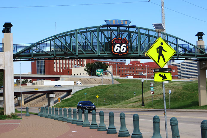
There are more giant statues to be seen as you pass through Oklahoma, including Buck Atom, the 21-foot-tall space cowboy in Tulsa holding a rocket. Tulsa also has a cool park downtown called the Cyrus Avery Centennial Plaza that has three tall old neon motel signs relocated there from the early days of Route 66. Further south is a Route 66 village with an old train, a gas station, and an oil derrick.
Route 66 in Tulsa, Oklahoma.
The last section of Route 66 I rode in Oklahoma was a mostly abandoned concrete road that paralleled Interstate 40, but you could tell it was part of the original route. How many mostly abandoned four-lane concrete highways going into nowhere with no traffic do you see? At one point, I thought I was off-track, but then I saw the Texas state sign and the familiar white outlined Route 66 logo painted on the road.
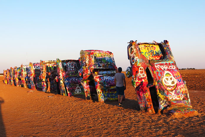
In Texas, much of Route 66 is access highways on either side of the interstate, which worked just fine for my trusty mule since I could travel at more relaxed speeds in the intense heat. Along the way, you pass by the Leaning (water) Tower of Britten in Groom, Texas, and Amarillo gives you the Cadillac Ranch.
Cadillac Ranch is located in Amarillo, Texas.
After visiting the Cadillac Ranch, I stopped at a KOA, and when I tried to start my bike again, it didn’t fire up. It turned out to be an issue with the ignition system, and despite having the parts from my other SR500 shipped to me to attempt a repair, it didn’t take. I cut my trip short and loaded the bike in the back of a Penske truck and headed back east.
In spite of a flat tire, intense heat and humidity, and an ignition failure, this was the most fun I can recall in most of my life. In retrospect, I should have tried making this trip on a newer bike, but part of the fun was riding a kickstart antique.
If you are considering riding this road, I would suggest waiting until 2026 for the 100-year anniversary since I heard plans in various towns along the way for some centennial events, so it should be even better.
One of the Green Country Oklahoma Adventure Tour’s (GOAT) most beautiful segments runs along a dirt road east of the Illinois River, accessed via Combs Bridge. Photos by Susan Dragoo.
If you’re planning a motorcycle tour in Eastern Oklahoma and you want to find the best roads and the most scenic and historic sites, take a ride with Oklahoma locals Bill and Susan Dragoo in this feature, “Riding the Territory,” from the pages of Rider magazine’s October issue. Scroll down for a route map and a link to the route on REVER.
Red skies silhouette the towering sandstone spires of Monument Valley. A six-horse team gallops across the movie screen in the foreground, pulling a stagecoach trailing a cloud of dust as the occupants desperately try to escape a band of mounted Plains Indians shooting arrows and sending up war whoops. It’s an exciting scene and an image that easily comes to mind when we try to picture life in the 1800s west of the Mississippi. The “Wild West,” in other words.
While that iconic scene may have occurred at some moment in time, a depiction of Western adventure somewhat closer to reality is the story of True Grit, in which aging U.S. Marshal Rooster Cogburn is recruited by a teenage girl to track down her father’s killer in the dangerous, outlaw-ridden Indian Territory during the days of “Hanging Judge” Isaac Parker.
Smooth asphalt winds through lush tree canopies in Eastern Oklahoma, illustrating how Green Country got its name.
The Indian Territory – what is now Eastern Oklahoma – truly had its share of outlaws in the days after the Civil War. Cattle rustlers, horse thieves, whiskey peddlers, and bandits sought refuge in the untamed territory. For many years, the only court with jurisdiction over white men in Indian Territory was the U.S. District Court for the Western District of Arkansas located in Fort Smith, where Judge Parker held the bench for 21 years and handed down 160 death sentences.
Those outlaw days left a colorful legacy still recognizable in places like Horsethief Springs, Robbers Cave State Park, and the Fort Smith National Historic Site. And thanks to its hilly topography, Eastern Oklahoma is not only full of historical riches but also rife with great motorcycle roads. The Ozark Plateau stretches over from Arkansas into northeastern Oklahoma, and farther south, the Ouachita Mountains provide an even craggier landscape. As a result, the roads – once foot trails, wagon roads, stagecoach routes, and military roads – are a playground for motorcyclists.
Wonderful paved twisties and miles of dirt and gravel backroads pervade the hills and hollows, flowing through this sparsely populated countryside. The feeling is one of remoteness, even if you’re never very far from a stretch of highway that will get you to an outpost of civilization.
We’ve spent much of our lives exploring Oklahoma. And while we live in the prairies farther west, the deep green forests and remote byways of the state’s eastern region keep drawing us back, time after time.
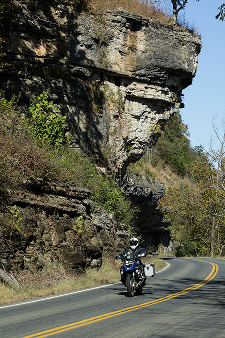
Limestone bluffs tower over twisty State Highway 10, the corridor to many of Eastern Oklahoma’s scenic delights.
For us, a perfect starting point for a multiday tour of Oklahoma’s “Green Country” is Tahlequah. Situated about 70 miles southeast of Tulsa, Tahlequah is the modern headquarters of the Cherokee Nation and the end point for the Cherokees’ forced removal from their homeland east of the Mississippi. This relocation took place during 1838 and 1839. Other eastern tribes affected by the forced-removal policy of the U.S. government that would later come to be known as the “Trail of Tears” included the Choctaws, Creeks (Muscogees), Seminoles, and Chickasaws. Along with the Cherokees, they were known as the “Five Civilized Tribes.”
For more information about Tahlequah and the surrounding area, visit TourTahlequah.com
Once re-settled in Indian Territory, they rebuilt their societies, governed themselves, and lived in relative peace and prosperity until the devastation of the Civil War, after which white settlers inundated the Territory. Oklahoma statehood in 1907 erased tribal sovereignty. In the 1970s, legislation restored the tribes’ ability to exercise powers of self-government, allowing entities such as the Cherokee Nation to thrive.
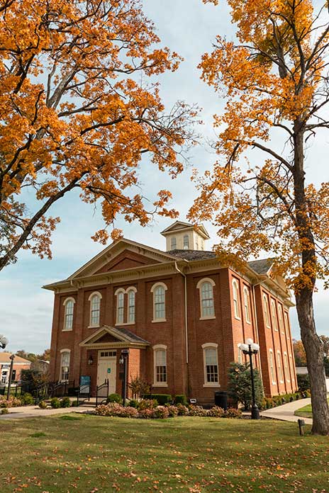
Tahlequah’s historic sites require a leisurely day or two to enjoy, so we recommend spending some time there seeing the Cherokee National History Museum, housed in the renovated Cherokee National Capitol. Also in downtown Tahlequah is the Cherokee National Supreme Court Museum, which was built in 1844 and housed the printing press of the Cherokee Advocate, the first newspaper in Oklahoma. This museum is the oldest government building in Oklahoma. Hunter’s Home in nearby Park Hill is the only remaining pre-Civil War plantation home in the state.
The Cherokee National Capitol in Tahlequah was completed in 1869. It now serves as the Cherokee Nation Courthouse. Photo courtesy Tour Tahlequah.
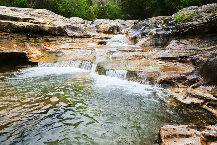
When you’re ready to get on the road, cruise north from Tahlequah on State Highway 10 along the Illinois River, one of Oklahoma’s few state-designated scenic rivers and a popular site for floating, fishing, and camping. Stay on Highway 10 or veer off at Combs Bridge, crossing the Illinois River to explore an easy dirt road squeezed between the river and the bluff. It winds through farmland and across an area of cascading water called Bathtub Rocks.
Bathtub Rocks is located in the JT Nickel Family Nature and Wildlife Preserve near Tahlequah.
At Combs Bridge, you can also pick up the Green Country Oklahoma Adventure Tour (GOAT), a route of about 500 miles almost entirely within the Cherokee Nation. The GOAT follows public roads with loose gravel, large rocks, mud, steep hills, and an abundance of water crossings, making for a lot of fun, especially after a good rain.
County Road 569 passes over Bathtub Rocks, offering a perpetual water crossing.
If you’re more into pavement, continue northeast on Highway 10 to U.S. Route 412 and detour to beautiful Natural Falls State Park, which offers a short hike to a 77-foot waterfall and dripping springs. Grab lunch in nearby Siloam Springs, Arkansas, and return west to Highway 10/U.S. Route 59 for a pavement ride north over Lake Eucha to State Highway 20, which takes you on a super-twisty route around Spavinaw Lake southwest to Salina, the oldest European-American settlement in Oklahoma. In 1796, Jean Pierre Chouteau encouraged several thousand Osage people to move from Missouri to what would become northeastern Oklahoma, establishing a trading post at present-day Salina. An old salt kettle in a city park along Highway 20 is all that remains of this rich history.
Clear, rushing brooks abound in the hills of Eastern Oklahoma; the one can be found tent-side in Tenkiller State Park.
From Salina, State Highway 82 returns you to Tahlequah, but if you have time, veer west on State Highway 51 and catch State Highway 80 for a jaunt south on a twisty paved road along the eastern shore of Fort Gibson Lake and continue to the Fort Gibson Historic Site.
Built in 1824, this was the first military post established in Indian Territory and was intended to maintain peace between the Osages and Cherokees. It figured prominently in the forced relocations of the 1830s and served as a base for military expeditions exploring the West. It was abandoned in 1857 but reactivated during the Civil War. The army stayed for some years after the war, dealing with outlaws and keeping the peace. Visitors can see a 1930s reconstruction of the early log fort and the stockade, as well as original buildings dating back to the 1840s.
Riding the GOAT after a good rain assures some adventure on low water crossings.
From Fort Gibson, loop back to Highway 82 and ride along the eastern shore of Lake Tenkiller, where Tenkiller State Park offers another good spot for camping, as well as lodging in cabins. Continuing south, a short detour out of Sallisaw brings you to Sequoyah’s Cabin Museum. Sequoyah created a system of writing for the Cherokee people and built this log cabin in 1829. It is enclosed by a stone structure built in 1936.
Camping and cabins at Tenkiller State Park offer beautiful sunset views.
Just north of Sequoyah’s Cabin is one of the more technical segments of the GOAT, the rough and rocky Old Stagecoach Road. Which stagecoach line used the road is unclear, but it is definitely old. The road shows up clear as day on a 1901 topographic map, following West Cedar Creek through a gap in the Brushy Mountains. With a moderate level of skill, an average rider can negotiate Old Stagecoach Road.
Continuing south takes you into the Choctaw Nation. At Red Oak, catch some twisty pavement over the mountains on Highway 82, ending up in Talihina. Or turn west at Red Oak on State Highway 270 and spend a day at Robbers Cave State Park just north of Wilburton, where Civil War deserters and outlaws – including the Youngers, the Dalton Gang, and Belle Starr – reportedly hid in the park’s namesake cave.
The colorful history and intriguing rock formations of Robbers Cave make it a popular destination.
Legend has it that the remote location and rugged terrain made the cave a nearly impregnable fortress, with the criminals able to escape through a secret back exit. We’ve been in the cave, and that “back exit” looks like a tight squeeze and a dead end. The park also features camping, lodging in vintage cabins built in the 1930s by the Civilian Conservation Corps (CCC), and some of the state’s best hiking.
Heading on toward Talihina, you enter the Ouachita National Forest and some of the most spectacular riding in Oklahoma, on or off pavement. The star of the show in this region is the Talimena Scenic Drive, which begins just northeast of Talihina. The serpentine 54-mile national scenic byway steeply ascends Winding Stair Mountains, staying on the crest as it crosses over into Arkansas. Across the state line atop Rich Mountain, Queen Wilhelmina State Park is a popular stop. At nearly 2,700 feet elevation, Rich Mountain is Arkansas’ second highest peak, and the spot offers breathtaking scenery when the clouds aren’t draped over the mountaintop.
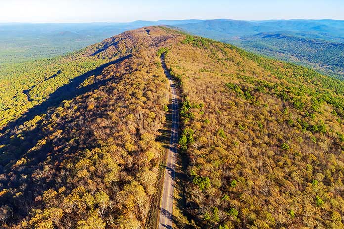
A bird’s eye view of Talimena Scenic Drive, a national scenic byway that follows the crest of the Winding Stair Mountains through Oklahoma and Arkansas.
The Talimena Scenic Drive also boasts multiple offshoots for unpaved riding, and hiking trails abound. One popular footpath is Horsethief Springs, which follows a route horse thieves used in the 1800s, making their camps and corrals near the top of the mountain near a perennial spring. A stone structure built by the CCC in the 1930s now surrounds the spring, which had run dry the last time we passed through.
For hardcore hikers, the 223-mile Ouachita National Recreation Trail runs along this same ridge. We’ve backpacked the trail from Talimena State Park to Little Rock, Arkansas, in a series of section hikes and can affirm that steep, difficult climbing does not require high elevations. Nearby you can also pick up the Oklahoma Adventure Trail for more off-road two-wheeled exploration. This approximately 1,500-mile mostly unpaved trail circumnavigates Oklahoma and offers a huge variety of terrain.
The Ouachita Trail’s 223-mile path is a backpacker’s delight, especially in the fall.
The Talimena Scenic Drive drops you off in Mena, Arkansas, and from there you can follow U.S. Highway 71 to Fort Smith. The Fort Smith National Historic Site and its surroundings offer a glimpse into a spot that was once the westernmost military post in the United States and later became best known for the justice meted out by Judge Parker. A reproduction of the gallows and Parker’s restored courtroom are among the exhibits.
From Fort Smith, take a leisurely ride north on Arkansas Highway 59, a scenic paved road hugging the border between Oklahoma and Arkansas. Along the way, make a stop at Natural Dam Falls, a lovely waterfall just off the highway. Near Dutch Mills, Arkansas, take a short side trip to Cane Hill, where you’ll swear you just emerged from a time warp. Attracted by the area’s natural springs, Cane Hill’s first European settlers established a township there in 1829. A museum and walking trails help the visitor interpret and explore the community’s well-preserved historic sites.
Jog back to Highway 59 northbound to U.S. Highway 62, which crosses into Oklahoma at Westville, the easternmost point of the Trans-America Trail as it begins its Oklahoma segment across the state’s northern tier.
Back in Tahlequah, pick up where you left off with historical exploration, or take a break and float the Illinois. No matter what you choose, take a moment to contemplate the Western history you’ve just experienced. Then go watch True Grit again.
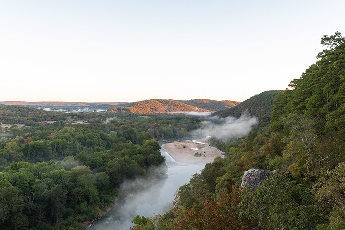
The rising sun typically burns off the fog in Eastern Oklahoma’s Illinois River valley. Photo courtesy Tour Tahlequah.
This article originally appeared in the October 2022 issue of Rider.
Bringing you the Best Motorcycle News from Around the Web!
We use cookies to ensure that we give you the best experience on our website. If you continue to use this site we will assume that you are happy with it.Ok