Tag Archives: Canada Motorcycle Rides

The Long Way Across Ontario on the Trans Canada Adventure Trail

Trans Canada Adventure Trail
Snowmobile trails become motorcycle trails during the summer. (Photos by the author)

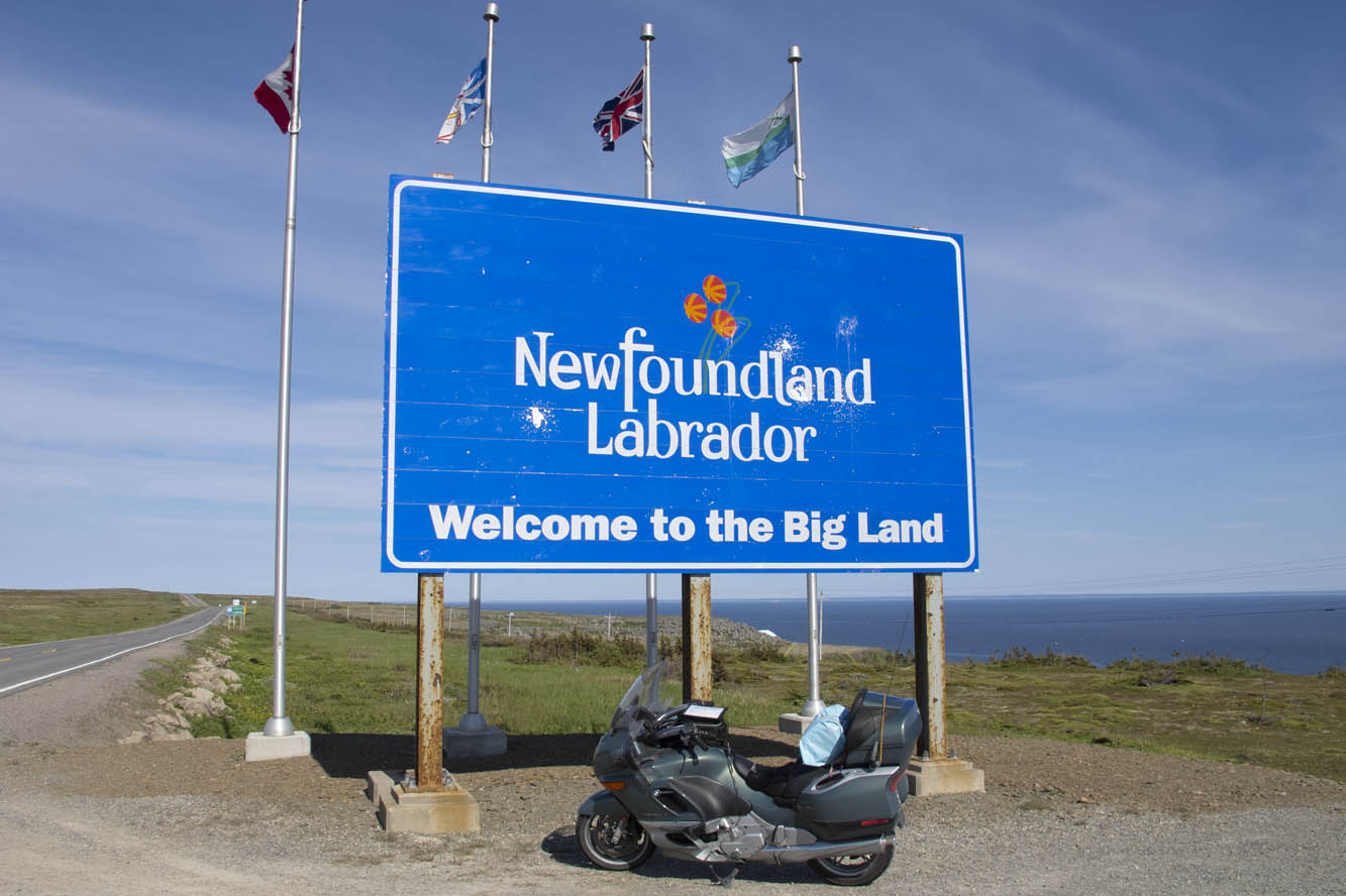
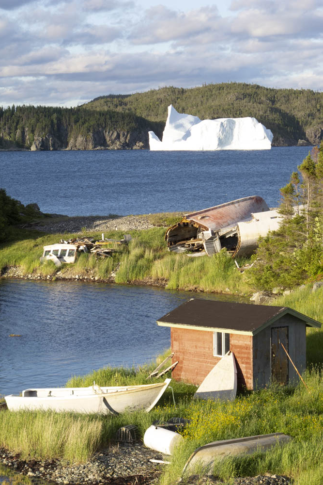
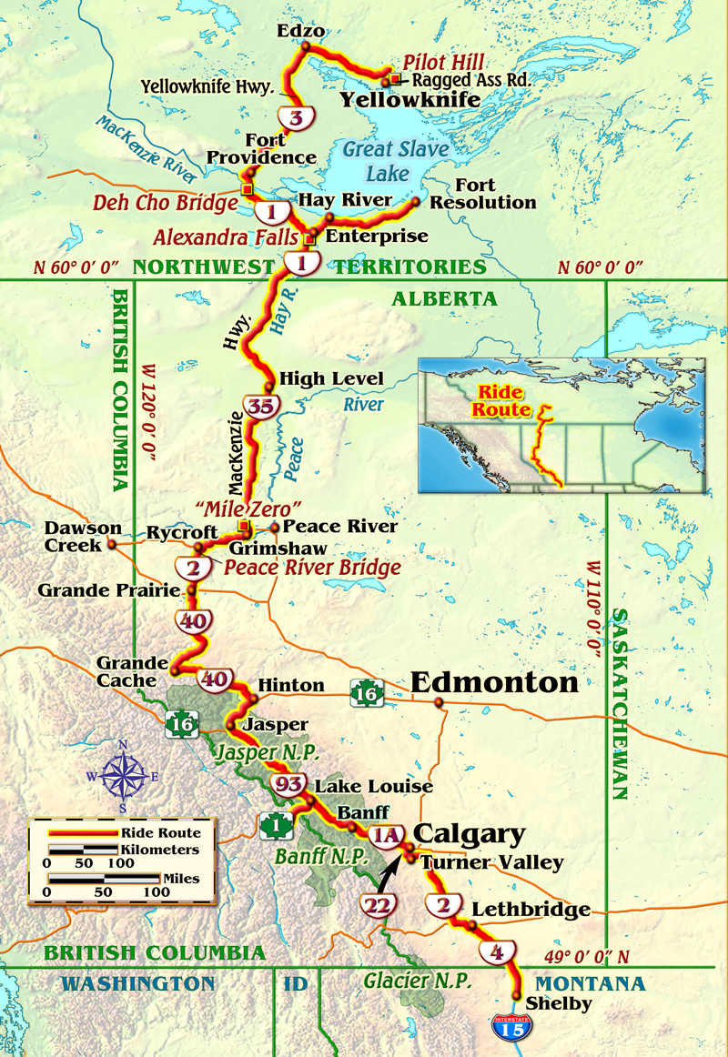
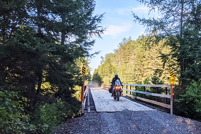
After months of planning and a morning of pavement riding, we arrived at a section of the Trans Canada Adventure Trail near Huntsville, Ontario. Our plan was to ride about 900 miles of the TCAT, which stretches 9,000 mostly off-road miles from Newfoundland in the east to British Columbia in the west (see sidebar “TCAT 101” at end of the story).

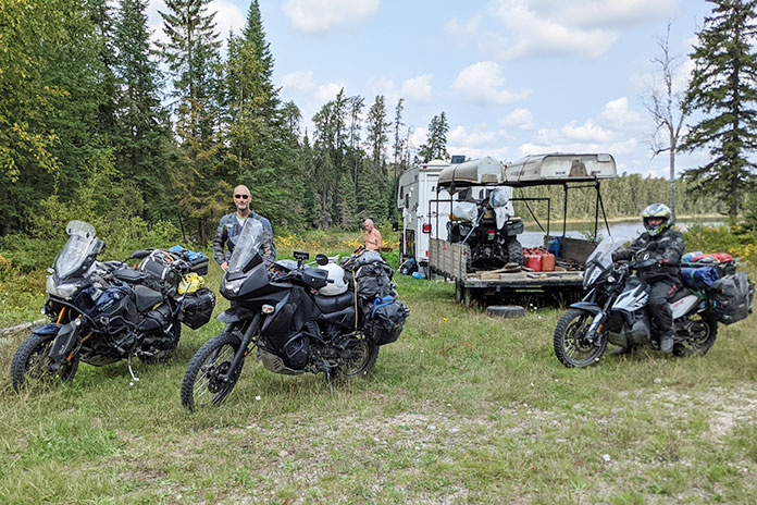
Our group was a fairly diverse threesome of riders. Dan, who had some dirt-riding experience, was concerned with how his Yamaha Super Ténéré would handle some of the tighter, more technical parts of the trail. Greg’s KTM 790 Adventure was probably the most off-road capable bike on this trip, but with almost zero dirt-riding experience, he didn’t know how he would handle the rigors of the trail.

I had the most dirt-riding experience, and with my new-to-me, BBQ-black enamel painted Kawasaki KLR650 – easily the ugliest bike on the trip – I was probably the least concerned with dropping my bike.

Related Stories:

Dirt Naps and Wet Boots

Trans Canada Adventure Trail
Dropping a bike in soft sand is a rite of passage.

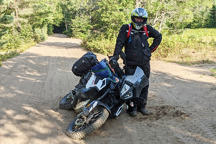
Within minutes of getting on the TCAT, we were faced with a fairly steep hill to climb with good-sized rocks and ruts. I made it to the top, but Greg lost momentum and fell, breaking his left side mirror. A broken mirror only five minutes into the off-road portion of the ride was not a great start. After the required photo, we righted his bike, Dan made the hill, and we carried on. 

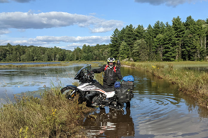
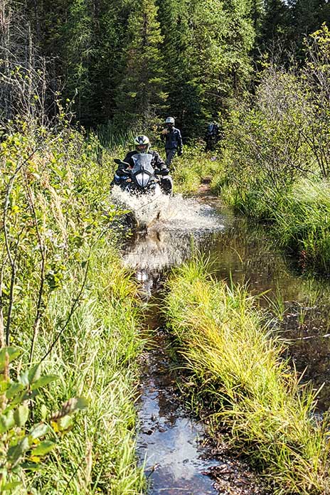
A few miles up the trail was the first deep, long water crossing with a pond on both sides. Greg again stumbled and got caught in a rut. In one scary moment, Greg fell, getting his bike twisted around and aimed directly into the pond we were crossing. One inadvertent twist of the grip and his bike would still be in that pond today. Getting it out ensured that both his and my boots were soaked, as waterproof boots are only effective when the water is not up to your knees. 

Trans Canada Adventure Trail
Greg heading the wrong way through a pond.

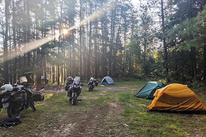
After Greg had another fall in some deep sand, we decided we should start looking for a spot to camp. Our plan for this ride was to camp on public Crown land (see sidebar) as often as possible to add to the adventure and reduce our costs. There promised to be a lot of Crown land up north, but we knew it might be harder to find where we were at that point. 

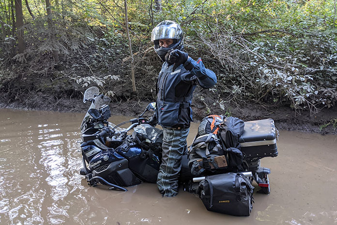
While looking for a camping spot, Dan led us through a puddle that looked on the surface like every other one we had recently splashed through. But this one was different. As Dan rode into it, his front wheel disappeared into the water, followed by the rest of his bike nearly up to the seat. He quickly hit the kill switch to avoid sucking water into the airbox and was stuck deep in the muck. After the requisite laughter and photos for posterity, Greg and I pulled him out backwards using a tow strap we had brought for such occasions. Now Dan was a member of Team Water-Soaked Boots.

Trans Canada Adventure Trail
Dan’s Super Ténéré deep in the muck. It took two of us, a tow rope, and water-filled boots to pull him out.

Related Story: A Solo Journey on the TransAmerica Trail

Trans Canada Adventure Trail? Or Zombieland?

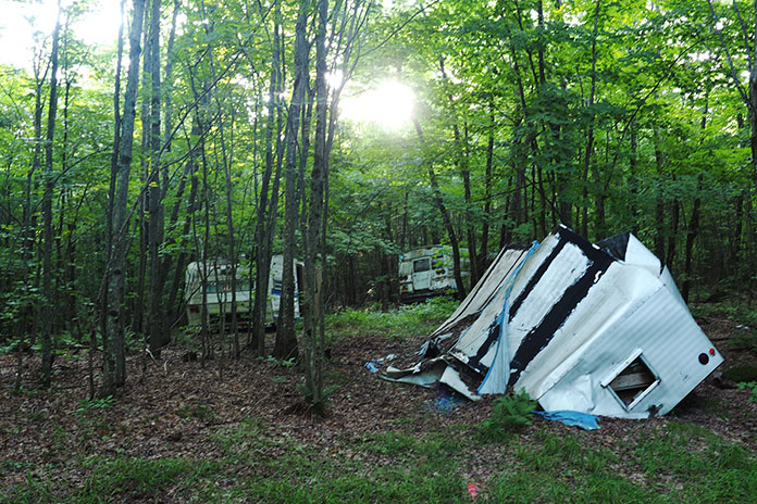
Exhausted and fearful of future bike-sucking puddles, we left the trail and camped in an area with several abandoned RV trailers and a bus, left to rot away in what appeared to be an unofficial RV graveyard. 

Trans Canada Adventure Trail
Camping at an unofficial RV graveyard the first night fueled our zombie dreams. Photo by Dan McPhee.

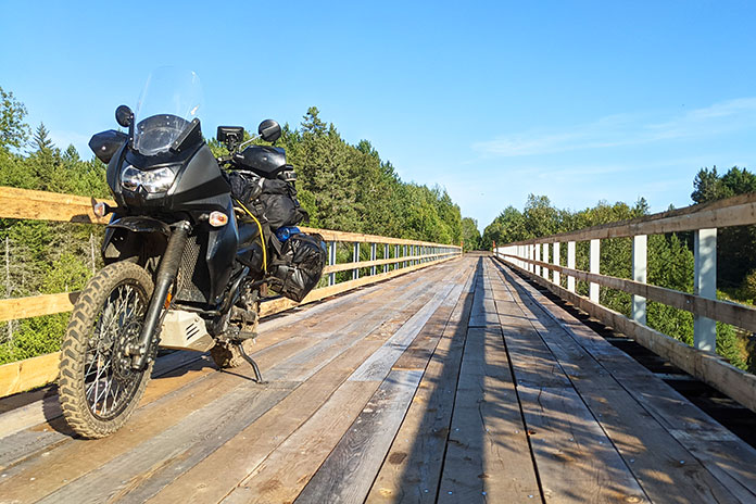
After a night filled with zombie RV nightmares, we found the TCAT again. The trail turned from an abandoned, pulled-up rail line to a narrow one-lane “road,” to a two-lane logging road, followed by a highway near North Bay, then back to an old rail line again. The variations of the route ensured that we remained focused, monitoring the terrain for rocks, potholes, and water. After what seemed like forever along an old rail line, heading west directly into the setting sun, we camped in my aunt and uncle’s backyard, which is a bit off the trail on a beautiful lake near Sudbury.

Trans Canada Adventure Trail
Crossing a bridge along an old rail trail between North Bay and Sudbury.

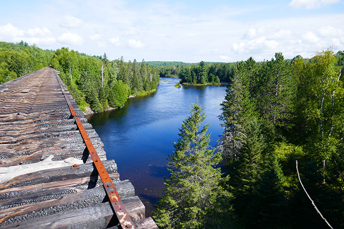
In the morning, we continued along the TCAT to an old rail bridge that we were not brave – or stupid – enough to cross. It seemed about 450 feet long and at least 100 feet high with no side rails. Many rail ties were missing, broken, or burned. There was evidence of snowmobile tracks on the bridge, but we agreed that trying to ride our bikes across was a terrible idea, so we backtracked and got on the highway toward Sudbury.

Trans Canada Adventure Trail
We crossed many bridges on the Trans Canada Adventure Trail, but we deemed this one too risky. Photo by Greg Fabris.

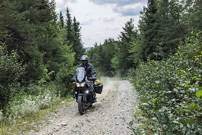
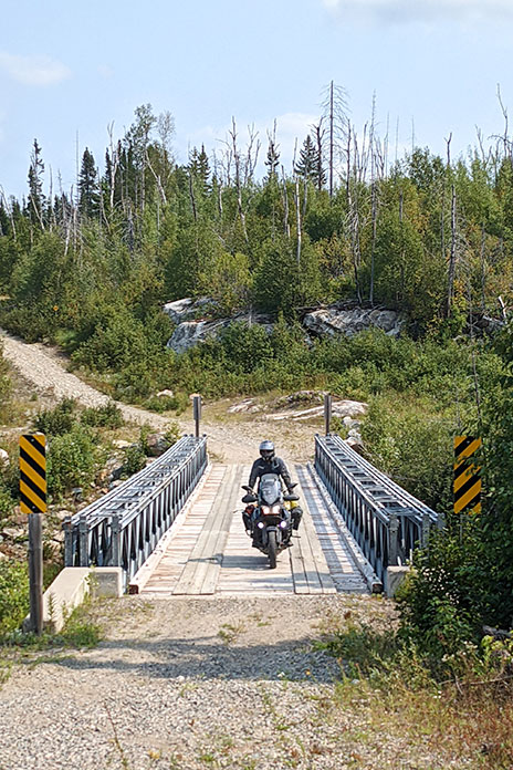
Once back on the TCAT north of Sudbury, we were totally alone. The road turned into a single lane with trees on each side. If two cars were to meet here, they would have to negotiate a path to allow each other to get by. We didn’t see any cars though – or anyone else. A stop near a river gave us a chance to enjoy the natural beauty and sounds of a seemingly endless supply of rushing water. The isolation was a rarity for us, and the peace of shutting our bikes off in the middle of the trail and hearing nothing but the gentle breeze through the trees never got old. 

The TCAT offers some alternate technical sections that roughly parallel the main track. One section we took follows a power line cut through the woods and offers up some decent challenges, including rocky ascents and descents. Several water crossings gave us some difficulties and wet boots, but we eventually made it through.

Trans Canada Adventure Trail
Having friends along for the ride means blunders are well-documented and help is available when you need it.

‘It’s log, log! It’s big, it’s heavy, it’s wood!’

Once off the technical section, the track had us on a road where the only traffic was logging trucks. There were three tire tracks in the gravel, and we tried to stay on the farthest right one, especially around corners, because the trucks use up the two left tracks and then some.

Trans Canada Adventure Trail
The lead dog stays dust-free on a logging road south of Shining Tree.

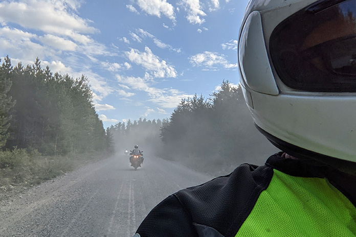
We almost choked in the dust thrown up by the trucks. One time, after two trucks went by in a row, I could hardly see the road in front of me and had to slow down for fear of going off the side. 

We found a nice camping spot just off the road with an outhouse, which, at this point in this isolated part of the province, was a luxury for us. 

Trans Canada Adventure Trail
Our campsite near a logging road. Dust hangs in the air from the trucks roaring by a few yards away.

After making it to Shining Tree the next morning, we bypassed the 60 or so miles of logging road the TCAT follows that would’ve taken us to Timmins and instead got on Highway 560 toward Watershed. The track again took us on a logging road toward Chapleau, where we stocked up on groceries, knowing that the next stretch would keep us away from civilization for more than 24 hours along some snowmobile trails toward Wawa.

Trans Canada Adventure Trail
Some bridges on the old rail trail have been updated and are easily passable for vehicular traffic.

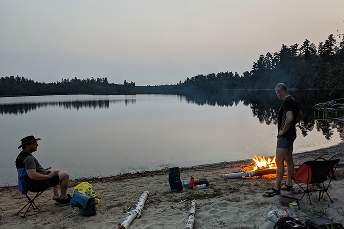
Leaving Chapleau, we rode on gravel roads for a while, and we started searching for a camping spot. Our goal was to find a spot that was roomy with plenty of space for a fire, as well as water nearby for swimming and collecting our drinking water. In this part of the province, there is a ton of Crown land, but our standards meant that we had some trouble finding a good spot that day. We finally found a seldom-used boat launch where we set up our tents as the sun was setting. We had a great fire on a beautiful sandy beach, listening to the calls of the loons on the otherwise deserted lake under the glow of the nearly full moon.

Trans Canada Adventure Trail
A beach campfire by an isolated lake makes for a great ending to a great day.

The next day our gravel road turned into a snowmobile trail, wide enough for a truck but with a lot of rocks, sand, and hills. Trails that are smooth and easy in the winter on a snowmobile can be treacherous in the summer on a motorcycle. 

Hello? Anyone Out There?

Isolation was our constant companion. We had seen only a couple of people since the previous afternoon in Chapleau. As we were riding along, a black bear suddenly darted out about 20 feet ahead. He quickly vanished into the bushes, but the shock of it stayed with me for a while, so I slowed my pace. Hitting a bear was not something I was keen to do. 

Trans Canada Adventure Trail
Another well-maintained bridge on the trail to Wawa.

Shortly after the bear sighting, we came across a clearing by a lake where someone in a truck camper had set up. Needing our morning coffee, we stopped and asked if he minded if we made our coffee by the water. Dan had a swim while I made the coffee, and we had a chat with the man, who said he loves the area and comes up every summer from Michigan with his canoe and ATV. He gave us a few pointers about the type of route we had ahead of us.

Trans Canada Adventure Trail
We had coffee with a fellow from Michigan who visits Northern Ontario every year.

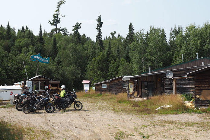
We arrived at Halfway Haven Lodge, which coincidentally is located about halfway between Wawa and Chapleau on the trail. It’s mainly a hunting camp and snowmobile lodge and was closed for our summertime visit. In the winter months, it has fuel and a few cabins for rent. A neat place in the middle of the Northern Ontario wilderness.

Trans Canada Adventure Trail
Halfway Haven Lodge, along the snowmobile trail between Chapleau and Wawa. Photo by Dan McPhee.

We continued on the sometimes rocky and challenging trail, which again followed a power line. It is safe to say that the power line portions of the northern Ontario TCAT are some of the most challenging sections. They are also the most interesting and offer some of the nicest views. Eventually the track turned back into a small road. It was another hot day, so we took advantage of a great swim spot on the side of a gloriously refreshing river. 

Trans Canada Adventure Trail
Riding along a power line north of Sudbury.

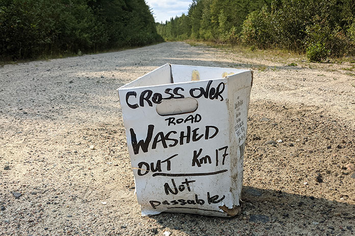
As we approached Wawa and the end of the TCAT portion of our trip, we came across a small box in the road with a handwritten note on it saying there was a washout ahead and the road was not passable. A man in a truck confirmed that the washout indeed made it impossible for us to get through. We considered going to check it out for ourselves, but Greg had reached his limit for gravel and trail riding, so we declared the end of our TCAT journey and made our way back to the pavement of Highway 11 and eventually home.

Trans Canada Adventure Trail
The sign that signaled an end to our TCAT travels – at least for now.

The section of the TCAT from Huntsville to Wawa was everything we had hoped it would be. If you crave isolation and remoteness without being more than a few hours from civilization and challenging adventure riding, the Ontario portion of the TCAT will reward you. We’ve already begun planning our next TCAT journey.

Trans Canada Adventure Trail Sidebar: TCAT 101

Trans Canada Adventure Trail

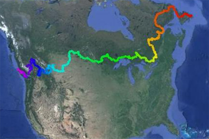
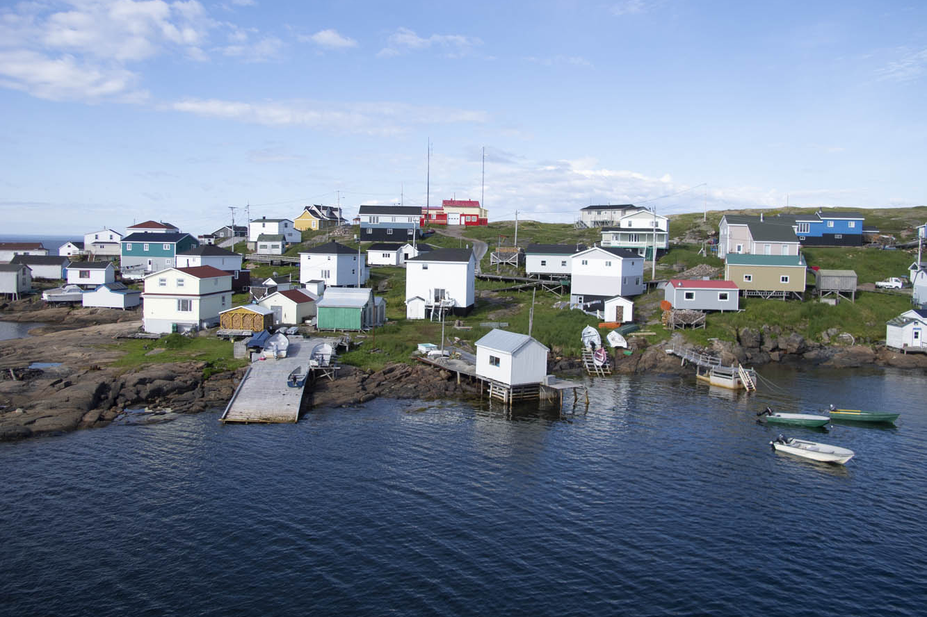
The Trans Canada Adventure Trail is a 9,000-mile route across Canada from the east coast of Newfoundland to the west coast of Vancouver Island. It started out as a concept in 2007, took five years to map out, and was put together with the help of many volunteers. Most of the route is gravel or dirt, with some pavement sections where necessary. If a rider is looking for more of a challenge, there are some alternate sections that are more technical than the standard route. Visit GravelTravel.ca for more information and to purchase the GPS tracks of the TCAT for $25.

Much of the TCAT in northern Ontario goes through Crown land (what Canadians call public land), and it’s important to obey rules about what you can and cannot do. Camping by Ontario residents is free for up to 21 days at any one site per year. Nonresidents must pay a fee of approximately $10 per night, and permits can be purchased online. For more information, click here.

The post The Long Way Across Ontario on the Trans Canada Adventure Trail first appeared on Rider Magazine.
Source: RiderMagazine.com

Beartooth and Beyond | Favorite Ride

Beartooth and Beyond Favorite Ride
Heading into the clouds of the Beartooth Pass south of Red Lodge, Montana. Photos by Marilyn Rich.

Hell yes! That is the only plausible answer when friends invite you to join them on an eight-day motorcycle ride through the mountains of Montana (including the legendary Beartooth Pass), Wyoming, Idaho, and Alberta, Canada.

We start our ride in Billings, Montana, on a pair of Harley-Davidson Electra Glide Classics rented from EagleRider, and head south to Laurel, where we pick up U.S. Route 212. We continue south to Red Lodge, where the road becomes Beartooth Highway and crosses into Wyoming on its way up to Beartooth Pass (10,947 ft). This is one of the best motorcycling roads in America, and it is easy to see why, even in the rain.

Beartooth and Beyond Favorite Ride

Scan QR code above or click here to view the route on REVER

West of the pass, we turn south on Wyoming Route 296, which is also known as the Chief Joseph Scenic Byway. The byway has great sweepers as well as picturesque views of the Absaroka Mountains as it climbs up and over Dead Indian Pass (8,071 ft).

Beartooth and Beyond Favorite Ride
Looking down on the Chief Joseph Scenic Byway.

We arrive in Cody in time to tour the Buffalo Bill Center of the West, a superb display of life in the Old West. The center has five museums: the Buffalo Bill Museum, which is about his life and times; the Plains Indian Museum, which showcases art and heritage; the Draper Natural History Museum, highlighting the ecosystems of Yellowstone; the Whitney Western Art Museum; and the Cody Firearms Museum.

Beartooth and Beyond Favorite Ride
The Buffalo Bill Center of the West in Cody, Wyoming.

We awake to a light rain that lingers until we head into the mountains west of Cody, and then the heavens open up with what my granddad used to refer to as “a real frog-strangler.” Looking over and around the windshield, I am barely able to make out the taillight of the bike in front of me, and I have no idea how he manages to follow the road on our way back to Beartooth Highway. The clouds part as we ride into Cooke City, Montana, a Wild West town where motorcycles have replaced horses at the hitching posts.

Beartooth and Beyond Favorite Ride
Crossing into Wyoming on the way to Beartooth Pass.

Our adventurous ride through Yellowstone National Park and Grand Teton National Park includes a wide variety of wildlife; a large RV that decides to stop, unannounced, in the middle of the road to take some pictures; and a herd of bison that crosses the highway one or two at a time, backing up traffic for a mile. When our turn comes to run the bison gauntlet, an exceptionally large bull gets ready to cross the road. We are directly behind a pickup truck, so I suggest to our riding partners that when the truck starts to move, we should stay close to its rear bumper so it looks like we’re being towed.

Beartooth and Beyond Favorite Ride
Buffalo looking for water in the parched Yellowstone River.

After spending the night in Jackson, Wyoming, we ride west on State Route 22 over Teton Pass (8,432 ft) and into Idaho. The winding roads, the views of the Tetons to the east, and crossing rivers with trout fisherman in waders fly casting made for a fun, scenic ride. We continue north on a stretch of U.S. Route 20 known as Mesa Falls Scenic Byway.

We cross back into Montana and end our day in Butte, once a wealthy copper mining town and more recently home to the late Evel Knievel, the legendary motorcycle daredevil. In the morning, we ride through downtown to view the mansions that signify a bygone era, and then head west through mining country. It’s Saturday morning and we are getting low on gas, so we stop in the tiny town of Phillipsburg to fill up. The gas station also serves as a general store, a casino, and a bar, all of which have numerous customers.

Beartooth and Beyond Favorite Ride
The Hidden Moose Lodge in Whitefish, Montana.

We turn north from Missoula in 100-degree temperatures, finally gaining some relief along the shady roads on the eastern shores of Flathead Lake. Heading back west across the top of the lake, we encounter the largest flock of eagles we have ever seen.

Beartooth and Beyond Favorite Ride
Going-to-the-Sun Mountain in Glacier National Park.

We spend the night at the Hidden Moose Lodge in Whitefish, an exquisite place that serves a gourmet breakfast every morning. With full bellies, the bike feels noticeably heavier as we climb Going-to-the-Sun Road through Glacier National Park, one of the few roads that can give Beartooth Highway a run for its money. We venture across into Alberta, Canada, and visit Waterton Lakes National Park, which is the northern part of the Waterton-Glacier International Peace Park.

Beartooth and Beyond Favorite Ride
Entering Alberta, Canada, at Waterton-Glacier International Peace Park.

Being from the flatlands of Florida, we’re overwhelmed by the endless peaks and scenery of the Rocky Mountains. We stay at the quaint Kilmorey Lodge, overlooking the Emerald Bay of Waterton Lakes. Relaxing by the gazebo with a refreshing beverage, we’re joined by countless white-tailed deer that consume any vegetation not covered in chicken wire.

Heading south the next morning takes us back across the border through the towns of St. Mary and Browning in northern Montana. A sign on the outskirts of Browning warns of strong crosswinds, but there’s nothing more than a gentle breeze. Ten miles farther south on U.S. Route 89, the breeze becomes a 60-mph crosswind that we battle with for the better part of 40 miles.

Beartooth and Beyond Favorite Ride
At Pine Creek Pass in Idaho.

The town of Dupuyer, Montana, has a population of 93 and no general store or gas station, but it does have two bars. We opt for the Ranch House of Dupuyer for lunch and are pleasantly surprised when the owner/bartender/chef cooks up a superb pulled pork dish. It’s served by his children, ages four and seven, who provide better service than waiters at many fancy restaurants.

After riding through the haze of wildfire smoke, we stay overnight in Great Falls. The final leg of our journey takes us across the flatlands to the small town of Ryegate, where we are disappointed to discover we’ve missed the annual Testicle Festival.

Beartooth and Beyond Favorite Ride
Lunch stop at the Ryegate Bar & Cafe in Ryegate, Montana.

We arrive back in Billings and return the Harleys to EagleRider. Over eight days and 1,500+ miles, I can say that there was not a single road that I would not ride again in a heartbeat. Great roads, beautiful country.

The post Beartooth and Beyond | Favorite Ride first appeared on Rider Magazine.
Source: RiderMagazine.com

Cages | Riding Indoors Looking Out

Cages | Riding Indoors Looking Out
Being part of the environment you’re traveling through – such as along the Stewiacke River in central Nova Scotia – beats looking out from inside a cage.

Cars aren’t motorcycles, although they can be useful. When I need to move more than a motorcycle can carry, or when it’s winter and the snow is piling up on the roads or when I must transport a passenger who’s not interested in riding there, a car is a good tool for the job.

But for enjoying the journey, most cars leave me wanting. Sitting behind locked doors and looking out through closed windows, occupants of a car miss clues to the world outside. The fragrance of blooming wildflowers, the sweetness of freshly cut hay, the tang of shade tobacco curing in slat barns, or the bite of salty air near the ocean are masked. Cars even coddle drivers and passengers with the creature comforts of home: climate control, carpeting, courtesy lighting, reclining seats, and more.

In a car, you are indoors looking out. You’re in a cage. On a motorcycle, you are outdoors, part of the environment and its sensory experiences. While I was riding through southwestern Nova Scotia bound for Cape Breton, the shore road didn’t always provide me a view of the ocean, but olfactory clues informed me that the tide was out. I also detected what a meteorologist described as “more of the smell of everything” when barometric pressure drops. Sure enough, the rain came while I had eggs, toast, and coffee in a roadside diner. My riding gear is waterproof, so despite a preference for sun, I didn’t let the rain spoil my ride.

Check out some of Rider‘s features

After breakfast I continued east along the shore. Hard, steady rain pelted my helmet, surrounding my head with the sound of popping corn. I pulled into the port town of Lunenburg, a remarkable sight even in the rain, and followed signs to the tourist welcome center where there was sure to be a restroom. Following much needed relief, I looked through the tourism exhibits in the lobby. In the continuing downpour, a sedan drove into the parking lot. Four car doors flew open and slammed shut, and four people sprinted to the building. Two teenaged girls arrived first, complaining about how wet they’d gotten. Their parents, trying to make light of their soaking, joined in the chorus, but one look at me in my wet riding attire made the father feel lucky.

“You must be soaked to the skin!” he said. I smiled and assured him that I was dry underneath my riding gear.

“Really?” he replied. “That’s funny. You’re riding on a motorcycle and you’re dry. We’re riding in a car and we’re soaked!”

I agreed; it was funny. Even the teens appreciated the irony. I pointed out that warm-air hand dryers in restrooms work great to dry clothes, and the girls and their mother disappeared into the ladies’ lavatory.

“Sorry you’re having to ride in bad weather,” the father said.

“There’s really no bad weather,” I replied, “just bad gear for the weather you’re having.” He smiled and asked what it’s like to ride a motorcycle in the rain. “It’s actually a lot like driving a car in the rain,” I explained. “Visibility and traction are reduced, braking distances are increased, and you need to watch your speed. What’s different on a motorcycle is you’re outdoors.” The father nodded and then headed into the gents’ facilities.

A few minutes later when he returned, still waiting for his wife and daughters, he continued the small talk. “So where are you headed?”

“Halifax tonight,” I replied, “then Cape Breton.” That was his plan too. He’d come along the shore road in search of scenic views, but fog and rain ruined that. I asked if he had noticed the scent of salt air along the shore road or felt the change in temperature as the road moved closer to the water, or if he had smelled low tide or detected that smell of everything before the rain came. He admitted noticing none of those things.

“That’ll happen when you’re in a cage,” I said.

“A cage?” he asked.

“A car.”

“Yes, a cage,” he chuckled. “I get it. That’s funny, too.”

His wife and daughters emerged from the ladies’ room with smiles and dry clothes, ready to resume their trip. Silently, I wondered how they would get back to the car without getting wet again. The father’s wry smile revealed what he was thinking: His family would soon be back inside their cage, insulated from the outside world in wet clothes, while the motorcycle guy would be taking it all in, outdoors but dry in his gear.

“Well, enjoy your ride,” the father said with a wave. “I’m sure you will. You’re not in a cage.”

The post Cages | Riding Indoors Looking Out first appeared on Rider Magazine.
Source: RiderMagazine.com

On the Road: Newfoundland

Newfoundland Labrador welcome sign
Coastal Labrador was the next stop.

Newfoundland and Labrador, the easternmost province in Canada, fights a losing battle patching its roadways. Realizing it’s a lost cause, the province simply erects signs along the way warning “Potholes Ahead.” It’s a challenging slalom on a motorcycle, let alone in a car. I watch the suspension jolt on the van ahead carrying my wife and two teenage sons. New struts and an alignment are in order upon our return.

St. John's Harbour
Signal Hill provides a panorama of St. John’s Harbour.

This is a cautionary tale about undertaking a “family vacation” when your family is in a van while you expect to experience the freedom of tagging along on your motorcycle. My wife, Nancy, has the notion of taking a ferry across the strait to coastal Labrador on the mainland to drive the mainly gravel Trans-Labrador Highway after we’ve finished our tour of Newfoundland. I, on the other hand, have serious reservations about adventure biking on my 850-pound beast of a BMW K1200LT, now with more than 200,000 miles on it. So, we will part ways after the ferry crossing to Labrador. And soon thereafter I would learn a bit of humility from some Canadian riders.

Cape Spear
Fog shrouds a lighthouse at Cape Spear, the easternmost point in North America.

Meanwhile, we have arrived on Newfoundland’s Avalon Peninsula after a 16-hour ocean crossing from North Sydney, Nova Scotia. We enter fog and wind on our southern loop around the peninsula by way of Trepassey Bay, common weather features in this part of the country. But conditions improve at Lord Baltimore’s Colony of Avalon, the best preserved early English colonial site in North America. Archaeologists continue to dig as we tour the area. At the nearby Tetley Tea Room by the Sea, we sample our first Newfoundland cod and wild berry treats.

Nearly 100 lighthouses once peppered the shorelines of Newfoundland and coastal Labrador, and we encounter our first ones at Cape Spear, the easternmost point in North America. One, dating back to 1836, is the oldest surviving lighthouse in the province. The more modern one, erected in 1955, houses an adjacent museum. Here we learn there are 23 staffed lighthouses remaining in the area. In the distance we saw Signal Hill, our next destination.

Newfoundland's Northern Peninsula
Twilight gilds the rocky west coast of Newfoundland’s Northern Peninsula.

We negotiated the downtown minefield of St. John’s to reach a better perspective of the city from Signal Hill National Historic Site. The narrow harbor entrance drove many a sailing ship to peril. A colorful regiment of signal corps were practicing for their daily tattoo in front of Cabot Tower, a sandstone Gothic Revival structure begun in 1898 to commemorate the 400th anniversary of Italian John Cabot’s discovery of Newfoundland and the 60th anniversary of Queen Victoria’s reign. Marconi received the first wireless transatlantic transmission here in 1901.

Canadian Signal Corps regiment at Cabot Tower
The Canadian Signal Corps regiment practices at Cabot Tower on Signal Hill.
Iceberg in Smith's Harbour
Icebergs like this one in Smith’s Harbour on the Baie Verte Peninsula float into coves and inlets aided by the wind and tide.

Nancy wanted to explore downtown St. John’s, while I desired to escape Newfoundland’s capital and largest city. Changed my mind at lunch in a rathskeller dive where we were served outstanding cod burgers and I discovered Iceberg Beer. St. John’s Quidi Vidi Brewery claims it is enhanced by pure 20,000-year-old iceberg water. I detect crispness in this pale lager that similar brews lack. Our two boys, both crew rowers, were excited to find out from our friendly waitress that the Royal St. John’s Regatta is North America’s oldest continuing sporting event. That’s appropriate, since St. John’s is the oldest English-founded city on the continent.

Port au Choix on the Gulf of St. Lawrence
Crab pots and trawlers stand ready at Port au Choix along the Gulf of St. Lawrence.

The Trans-Canada Highway leads us inland through the Eastern Region. Insidious longitudinal potholes jar the unwary. Canadians whoosh by, heedless of the hazard. My shocks are taking a beating, and they were leaking even before this trip. We set up camp at Notre Dame Provincial Park in the Central Region, and I take to the van for exploration around Twillingate. At Boyd’s Cove, we visit the Beothuk Interpretation Centre to learn about the extinct native inhabitants of Newfoundland.

In a tiny outpost called Clarke’s Head, I backed the van into a local’s vehicle at a gas station. “See what trouble I get into when I’m off the bike?” I say to my wife. The Newfoundlander was almost apologetic for being in my way, and we parted in friendly fashion. I can’t imagine that happening back in New York.

Iceberg Alley
Iceberg Alley extends into the harbor at St. Anthony on the tip of the Northern Peninsula.

I mounted the bike for our next excursion up the Baie Verte Peninsula. The 50-foot skeleton of a humpback whale was worth scrutinizing at King’s Point. On the way to the tip of the peninsula at Fleur de Lys, we diverted to Smith’s Harbour, having learned that a huge iceberg had settled there. Indeed it had, and a picture perfect little place it was. These bergs drift off from the Labrador Current into nearby harbors, bays, and coves brought here by the wind and tide.

Back in the town of Baie Verte we learned about the peninsula’s rich mining history. Indeed, we passed a huge abandoned asbestos mine on the way to Fleur de Lys, where soapstone was quarried by the Dorset Paleo-Eskimo some 1,600 years ago. After reaching the end of the road, we were about to turn around when a pickup raced up and blocked our way.

Humpback whale breaches in St. Anthony Harbour
A humpback whale breaches in St. Anthony Harbour on the Northern Peninsula.

The driver turned out to be a friendly local resident who noticed our New York license plates and wanted to chat. Encounters like this were common for us throughout Newfoundland.

So far, our progress was slow. Stopping frequently and visiting the numerous outport villages didn’t accumulate the mileage. Many were the dead-end roads we explored. I reviewed my mileage log once we were in the Western Region: 70 miles one day, 105 miles the next, followed by 90 miles, 62 miles, then zero, zero. Aaaughh!

Seal on an ice floe
A seal basks on an ice floe.

I finally rode a 200-mile day from Baie Verte to Trout River campground in Gros Morne National Park. This area is a UNESCO World Heritage Site defined by ancient up-thrust landscape forming the tip of the Appalachian Mountains. The Tablelands region exposes examples of the earth’s mantle. Glaciers carved out a fjord at Western Brook Pond, where we took a boat ride beneath 2,000-foot cliffs. Ice fields cling to crags, offering summer habitat to the caribou and puffins.

If there was a central point to this wilderness, it would be picturesque Rocky Harbour, sheltered by a lighthouse promontory and twin Appalachian ridges dipping into the Gulf of St. Lawrence. The Gros Morne Wildlife Museum in town is worth a look. The Ocean View Hotel displays unique local artwork and hosts the Anchor Pub, where one can be “screeched in” as an official Newfoundlander. The boys were greatly disappointed they weren’t allowed to drink the rum and kiss a codfish. Earl’s restaurant offered moose burgers, moose soup, moose pizza, and any other variety you’d like. We left sated.

Norsemen sign
Norsemen landed here in 1,000 A.D.

I gave the BMW free reign on Route 430 up the western coast of the Northern Peninsula, a smooth-surfaced road flowing alongside the Gulf of St. Lawrence, with the Long Range Mountains framing the eastern horizon. Felt like being back on Highway 1 in California. This is the Viking Route that would lead us to the first established European settlement in North America at the very tip of the Northern Peninsula. It also has the largest density of moose on the continent, and we had already seen several.

We had fun interacting with interpreters at L’Anse aux Meadows National Historic Site, location of the Viking presence here in 1,000 A.D. We walked through a reconstructed encampment of turf-walled longhouses while re-enactors stayed in character demonstrating the daily life of the Norsemen. Our tour continued at nearby Norstead, a living history site of additional costumed interpreters and a fully replicated Viking ship.

Viking village at L'Anse aux Meadows
Reconstructed sod huts replicate the Viking village as it would have appeared 1,000 years ago at L’Anse aux Meadows.

We hit paydirt in St. Anthony, viewing a harbor filled with icebergs. A boat tour brought us up close to these ice cathedrals. A humpback whale breached for us several times. A pod of minkes came alongside the boat. A seal reclined upon his private ice floe. We absorbed the opportunity, because two days later the icebergs had broken up, which can happen quickly we were told. By mid-July any icebergs become a rare sight.

A ferry took us across the Strait of Belle Isle to coastal Labrador. A 50-mile ride brought me along the strait and over the mountains to Red Bay, a 16th-century Basque whaling port. Red Bay also offers access to the Trans-Labrador Highway, and this is where my family and I parted company. I had reservations aboard a supply ship that routinely sails upstream to replenish harbor towns with no connecting roads along the Quebec coast.

L'Anse Amour welcome sign
Around the promontory in the background of this coastal Labrador village rises Canada’s second tallest lighthouse and an ideal spot for whale watching.

I returned to the ferry landing at Blanc-Sablon, Quebec, and lined up with other motorcyclists early on a rainy morning. The bikes were loaded two to a container, tied down, and hoisted by a mammoth boom crane into the vessel. Two Honda ST1300 riders humbled me because they had just completed the Trans-Labrador trek. We would disembark where the road begins anew in Natashquan. Or so we thought.

Circumstances changed upon reaching the village prior to Natashquan hours behind schedule. We all had reserved respective B&B inns in Natashquan, where we wouldn’t arrive now until the wee hours of the morning. We learned there was indeed a 20-mile road from the village to Natashquan, but it was all gravel. Nonetheless, all riders, except me, decided they would disembark here and risk the unfamiliar road in the midnight blackness.

Motorcycle supply ship
Riders lined up for loading into the supply ship heading up the Gulf of St. Lawrence and coastal Quebec.

Now, I’ve ridden my share of gravel roads, I told them. Even did the 1,200 miles of Alaska Highway when it was unpaved. But I was much younger and more fearless. My concern today was dropping my precious K1200LT, resulting in thousands of dollars in cosmetic damage. But my bike shared a container with one of theirs, and all looked askance at my weak rationalization. To regain self-respect, I agreed to accompany them.

It turned out to be the most anxiety-inducing 20-mile ride of my life. Inky blackness and bunched gravel had me plowing from one side of the road to the other, trying to find a tractable groove. It didn’t help that I was reluctant to get the speed up. One of the Canadians on his Kawasaki Tengai remained behind me for assurance, urging me to stand on the pegs and go faster, while the rest shot ahead. Such humiliation, I thought. When we finally caught up, the group was parked at a pullout on the outskirts of town.

Harrington Harbour was one of our supply ship’s many stops to replenish ports along coastal Quebec not connected by any roads.

“How’d he do?” asked one of his Canadian co-riders.

After a slight pause and a sly smile directed at me, he replied, “Slow, but steady.”

And with that turn of phrase, my newfound Canadian friend preserved my dignity, eliciting congratulatory backslapping and an acknowledgment of a successful ride all-around by the French-Canadians in a language universally understood.

The next day, while imagining my wife and boys bouncing along the rutted Trans-Labrador – views blocked by boreal forest and swatting at clouds of black flies – I rode 390 blissful miles of coastal Quebec. Open-road freedom never felt so good.

The post On the Road: Newfoundland first appeared on Rider Magazine.
Source: RiderMagazine.com

Favorite Ride: Prince Edward County

Favorite Ride: Prince Edward County
Shady ridge road just above the Black River Cheese store.

Snik. That’s the sound of my 2016 Yamaha FJR1300 moving up a gear, more specifically into the model’s new 6th gear, calming my ride just a bit more as I settle into that Zen state of rolling meditation. I’ve just left Kingston, Ontario, on the Canadian northeast corner of Lake Ontario, and I’m heading west for Prince Edward County (PEC), a peninsula of land identifying more closely with the lake rather than with the land just to the north. As I head down Ontario Highway 33, a.k.a. Bath Road, a welcome drop in temperature affirms this association. The cooling air is always the first taste of my favorite ride.

Highway 33 carries me hard by the water, inviting me into gently sweeping curves and picturesque straights offering farmland views on the right, and wide-open waterscapes on the left. Not technically challenging, but oh-so satisfying. The villages of Millhaven, Bath and Adolphustown float by, as do seasonal roadside offerings of sweet corn, strawberries, apples and veggies of all kinds. Tonight’s supper, conceived and assembled on the spot, will be the cherry topping.

Favorite Ride: Prince Edward County
The Quinte Skyway Bridge in the distance, heading north out of the county.

Just west of Adolphustown the Highway ends at the Glenora Ferry, crossing the 1-kilometer Adolphus Reach in the Bay of Quinte in about 20 minutes. The first commercial ferry license here was granted in 1802, accommodating the loyalist settlers on both shores. The ferry operates on a 30-minute schedule in the off-season, and during the summer two ferries swap shores every 20 minutes. The cool crossing is an opportunity to hold informal meet and greets with other riders, as there is always a group bound to explore PEC.

Immediately off the ferry and now formally in PEC, I take a hard left onto County Road 7, up to Lake on the Mountain. The road rises 62 meters in less than a kilometer, throwing in a 180-degree curve that challenges me to set the bike into a hard lean, holding it in a constant line, no bobbles, no braking, always trying to up my “smoothness quotient.”

Favorite Ride: Prince Edward County

At the top is, yes, a lake, 62 meters above the ferry, but in a straight line less than a kilometer away; a geologic rarity. Washrooms, restaurants, an inn and a viewing area overlooking the Reach are available here, but no camping.

Continuing on 7 moves me into the back county, where the ride eases into quiet rural landscapes, shaded lanes and past the occasional lazy farm dog at the roadside. Again, not a technical ride, no “hair on fire” cornering here. It’s more Mozart than Led Zeppelin; more a state of mind, a quiet escape into an earlier reality.

Favorite Ride: Prince Edward County
Meet and greet on the Glenora Ferry. A chance to talk to other riders.

PEC developed as arriving loyalists carved out homesteads, but today the cool climate invites a newer purpose. In 2007 the County was designated as the fourth DVA (Designated Viticulture Area) in Ontario. More than 40 wineries will tempt you, along with all kinds of craft cheese and beer, and art galleries displaying local talent. Info on wine tasting tours can be viewed at princeedwardcountywine.ca.

I turn south and pick up County Road 8 traveling east to visit Waupoos Estates Winery, one of my favorites. A nice Cabernet will accompany my meal tonight. Heading back west I pick up County Road 13 for some excellent five-year-old cheddar at the Black River Cheese store. Continuing on 13 takes me out Long Point Road. The road opens, and I can move my girl up to 6th. Snik. Lovely smooth.

Favorite Ride: Prince Edward County
Waupoos Estates Winery, elegant and welcoming. Parking in front, restaurant patio out back, and lots of goodies offered inside.

At the end of Long Point Road you’ll find the Prince Edward Point Bird Observatory. Spring and fall bird banding takes place here, and the public is welcome. During migration the station may band more than 200 birds a day, and trails going back to the mist nets are open to the public for viewing and photography. Info online can be found at PePtBo.ca.

Turning west again, the ride takes me toward Sandbanks Provincial Park. Jumping from one County Road to the next eventually places me on County Road 18, which runs into the park. If you get off track, well done. You’ll probably discover another winery.

Favorite Ride: Prince Edward County
Kilometers of fine sand beaches and warm waters make Sandbanks Provincial Park a first-rate destination for locals and tourists alike. Book camping sites early to avoid disappointment.

Once in the park, paths lead over the dunes to the beach. Sandbanks Park boasts the world’s largest freshwater barrier dune formation, another geologic rarity. Once onto the beach you’ll wonder how you ended up in Florida. Warm shallow waters, kilometers of fine sand beach and 500 campsites are available from late April to early October. Check out Ontarioparks.com/park/sandbanks for more info, and book early. Day visits cost $12 CDN. Pack your thong.

Heading west again, you can pick your route from a weave of bucolic pathways. Today I feel more straight line than curvy, so I ride up to County Road 1 and snik up to smooth sixth. Riding past Lake Consecon I head for a little pullover I know, sneaking the big bike through 30 meters or so of a shaded lane that puts me on a secluded smooth pebble beach for lunch.

Favorite Ride: Prince Edward County
A short lane off a county road leads to a secluded smooth pebble beach for lunch and a nap. Leave the wine in the side bags until the evening.

Rested and fed, I cross back east to County Road 14, then County Road 15, and leave PEC via the Bay of Quinte Skyway Bridge. As if the peninsula hasn’t offered enough, the waters under the bridge are home to a world-class Pickerel fishery, drawing anglers in from all across North America. Charters are available. Info on all this and more can be found at prince-edward-county.com.

Finally turning back to Kingston, the round-trip ride is roughly 300 kilometers, depending on which roads you choose to explore. I head east onto Highway 2, and those longer meditative straights open up in front of me. Snik. 

Favorite Ride: Prince Edward County Photo Gallery

Source: RiderMagazine.com

The Breadbasket of British Columbia: A Sweet Ride in Okanagan Country

Bear's, or Bear Frasch's Farm Market
Bear’s, or Bear Frasch’s Farm Market, holds a special place in my memory. This market north of Keremeos is where I would stop as a kid traveling with family to stock up on peaches and cherries. Photos by the author.

With many rides I have a sense of where I’m going but the details come out later. For this one I had a specific goal: I wanted to explore the roads my parents took me along as a kid in a Ford LTD, towing a tent trailer behind. We would always stop at fruit stands in the Okanagan region of British Columbia and pick up peaches, cherries, berries…whatever was in season. We’d nibble the fruit along the way or wait to eat it at a campsite. I wanted to visit these food-growing parts of my home province again and renew my connection with the roads and farms where the food I eat in Vancouver comes from.

Looking for a riding buddy, I gingerly pushed my BMW F 650 GS down a gear into third before taking the exit off Highway 3 into the parking area of Manning Park Resort, which sits among the colossal Cascade Mountains. My friend David Powell had been exploring the roads of the Similkameen Valley, just east of E.C. Manning Provincial Park, on his Honda CB500X for a week, and I was keen to join him and find out what he’d learned. After a quick bite to eat, we were back on the road.

British Columbia motorcycle ride
Map of the route taken, by Bill Tipton/compartmaps.com.

Before we made our way to Princeton, where we’d sleep that night, David was already suggesting a ride off the beaten track, up the switchbacks of the paved road to the Cascade Lookout. We crossed Highway 3 and proceeded to make a serious climb, the tree-lined edges of the road without a guardrail, before reaching what must have been a new record above sea level for my BMW. What lay before us was spectacular. Dominant in our view was Frosty Mountain, at nearly 8,000 feet. Just beyond was another peak of note on the other side of the 49th parallel. Hozomeen Mountain stands at just over 8,000 feet, among the North Cascades of Washington State. David and I were quietly mesmerized by the view. It was a great start to our three-day journey.

Cascade Lookout
Identifying peaks at the Cascade Lookout can be complicated; Manning Park Resort lies below.

We wound our way along Highway 3, a.k.a. the Crowsnest Highway, a large open pit copper mine to our right declaring our arrival in Princeton. Over dinner at a restaurant suitably named The Copper Pit, I suggested a theme for our ride, one that would begin with some stops at the Okanagan fruit stands I remembered well.

Next day we rode east out of Princeton on what would be one of many secondary roads we would travel, the Old Hedley Road. This windy path following the Similkameen River had us both flicking our bikes back and forth, enjoying the occasional view of morning sunlight reflecting on the water and getting into the rhythm of a road trip of several days. The occasional recreational site with a picnic table and fire pit made it tempting to stop and enjoy a night of camping by the river.

tractor in Similkameen Valley
A tractor with some history bakes in the sun near Bear Frasch’s Farm Market, with the hills of the Similkameen Valley behind it.

Joining briefly with Highway 3 again, we twisted the throttles to get to highway speeds. The increasingly mountainous landscape was dotted with ponderosa pine and bluebunch wheatgrass. We rode past the town of Hedley, the steep slope above displaying the decaying wooden remnants of the famed Nickel Plate gold mine, and would soon stop on the western outskirts of Keremeos, known for its many fruit stands in this community of orchards. One of the standout purveyors of fruit is the Mariposa Fruit Stand. With a big painted sign of a coyote in a hat lounging among a bunch of produce, it coaxed David and me to pull our bikes into the lot and have a look around the shop. It was June and that meant cherry season, judging from the boxes and boxes we saw prominently displayed at the entrance.

cherries on display at the Mariposa Fruit Stand
The first of the summer cherries on display at the Mariposa Fruit Stand.

Back on the bikes, we soon stopped for lunch in the quirky historic town of Keremeos, also not surprisingly called the “fruit stand capital of Canada,” pulling in next to many other motorcycles. Many others cruised by at slow speeds. After picking up wrap sandwiches to go, we were back riding, countersteering left and onto Highway 3A for a brief stop at Bear Frasch’s Farm Market. No camping trip into British Columbia when I was a kid was complete without a stop here. The August peaches hadn’t arrived yet, but there were plenty of apples and more cherries to drool over. With a glance at the abandoned old tractors rusting away in a field, David and I were off to take a side road of his suggestion to Penticton: Green Mountain Road. After a left onto a road that clearly had some history behind it, we plunged into some twists and turns in a wooded area that had me smiling in my helmet. We banked the bikes to and fro and hardly saw a soul, except for another group of four motorcyclists coming the other way. David’s research had paid off. He had been suggesting I take this road for years, and we were finally riding it together. When we started to see the outskirts of Penticton, I wished we could go back and ride the road again, if it weren’t for my low fuel reserves.

BMW F 650 GS at the Mariposa Fruit Stand in Keremeos, B.C.
The author and his 2010 BMW F 650 GS at the Mariposa Fruit Stand in Keremeos, B.C.

Soon we were riding alongside Okanagan Lake on Highway 97, traveling through the idyllic towns of Summerland and Peachland, soaking up the sun’s rays. Riding alongside beaches on a hot day may be the one thing that makes me want to put the sidestand down, strip off my riding gear and go jump in a lake. But I resisted, and looked forward to the next scenic route, heading downhill to the lake. In order to not get caught up in the stifling traffic of Kelowna, David and I pulled off at Westbank onto Boucherie Road, angling our bikes toward a refreshing stop to cool us down.

It may not be a cool leap in a lake, but a stop to picnic in the shade by an Okanagan winery will do just fine. The light glinted off Okanagan Lake in the distance as we nibbled on oranges, glancing out at the rows and rows of vines stretching down the hill to the water on the Quail’s Gate Winery.

Quail's Gate Winery
The rows of vines at Quail’s Gate Winery overlooking Okanagan Lake.

There’s nothing more uncomfortable than sitting in traffic on a motorcycle on a hot day. So David told me of an alternative route he had found that not only avoided the Kelowna snarl, it also took on splendid views of Okanagan Lake (yes, it’s a big lake) and many twists and turns. Lead on, David! Westside Road took us on an odyssey of curves while we stole glances at houseboats and jet-skiing lake users as we geared up, then geared down to take on curves and accelerate out of them, over and over again as we approached the end of lake country and entered dairy farm country. Passing through the Spallumcheen Indian Reserve we crossed Highway 97 to end up on St. Anne’s Road just south of Armstrong, known for its cheddar and other milk-derived foods. David was getting warm so we stopped by a farm for a break, and listened to the tick-tick-tick of an industrial sprinkler spraying water over a burgeoning cornfield.

Westside Road rimming Okanagan Lake.
David Powell checks the map after a brisk ride along the Westside Road rimming Okanagan Lake.

Soon we were riding Otter Lake Road south of Armstrong along the green pastures of dairy farms, cows watching these strange two-wheeled devices speed past them as they chewed their cuds. Tucker’s Restaurant in the quaint town of Armstrong served us dinner before we rode winding Salmon River Road across one-lane, wood-planked bridges with the sun dipping down, dappling our helmets with light through the trees. We were brought to Highway 97 heading northwest, the setting sun in our eyes as we passed through historic towns like Falkland. Sprinklers in vast sunset-covered alfalfa fields threw huge arcs of spray, growing future hay for hungry milk-producing cows.

There was one more secondary road to take, Barnhartvale Road, just north of Monte Lake, which would take us through more farmland south of the Trans-Canada Highway. Rather than take the main highway, it made sense to ride a more scenic and windy passage to Kamloops. As we returned to the suburban sprawl of the city, I couldn’t help but emit a groan and wished to return to the back roads David and I had traced all day, past farms, rows of grapes and fruit and vegetable stands pitching their wares.

Ferrari parked outside of Quail's Gate Winery.
Getting a sense of the clientele…a Ferrari parked outside of Quail’s Gate Winery.

David and I parted the next day. He was going to continue riding (lucky guy) and I was heading back home to Vancouver. But taking David’s advice (why stop now?) I took Highway 5A, also known as the Old Kamloops Road, a much more charming and snaking passage south than the rapid, vapid Highway 5. This way I managed to pass by some lovely lakes, witness Sunday fishing parties cast lines from their boats and stop in at beautiful Nicola Lake near Merritt to observe a family with kids set out from a boat launch for a day out on the lake. It made me keen to return to my own family in Vancouver and tell them about where our milk, cheese, wine, fruits and vegetables come from and how lucky we are to live in such a diverse, plentiful and scenic part of the world.

vineyard British Columbia

Source: RiderMagazine.com

Riding Nova Scotia’s Worst-Kept Secret: The Cabot Trail

The Cabot Trail offers 186 miles of winding roads and exhilarating scenery. Photos by the author.

At just 360 miles, you could probably ride the entire length of Canada’s second-smallest province in a day, including Cape Breton Island on the north end. Having said that, you could also spend a good 3-4 weeks exploring the coastal roads that encompass Nova Scotia. But despite the appeal of the many lightly-traveled roads along the coast, the main allure for me and many motorcyclists all over North America are the legendary roads on Cape Breton Island.

Map of the route taken, by Bill Tipton/compartmaps.com.

My first stop in Nova Scotia was along the South Shore. From here, the ride was about 190 miles to the Canso Causeway, which joins Cape Breton Island to the mainland. As soon as you are within a couple miles of Port Hastings, the first town you enter once you cross over the causeway, you will immediately notice an increase in the bike-to-car ratio.

Winding roads overlooking an endless valley of trees north of the Cape Breton Highlands National Park.

Although the Trans Canada Highway runs up the middle of the island and is the more direct route to the Cabot Trail from Port Hastings, you would be doing yourself a disservice by cutting out Trunk 19, also known as the Ceilidh Trail. It is a 66-mile scenic road that rims the Gulf of St. Lawrence, starting at Port Hastings and ending at Margaree Forks, which is a southern point on the Cabot Trail. The paved road passes through quaint Scottish towns offering reasonably priced accommodations that are more accessible than the lodgings on the Cabot Trail.

Accommodation in Margaree Forks, which is on the southernmost part of the Cabot Trail. The Normaway Inn offered cabin rentals that were reasonably priced, and live Celtic music featuring local talent.

Up until this point in my trip, I would use my last fuel stop of the day as an opportunity to pull out my phone and assess the availability of the local motels. This strategy will not work on the Cabot Trail, especially if you are planning your trip over a weekend in the summer, because everything seemed to book up really fast. However, there is an abundance of B&Bs in the towns along Trunk 19, a perfect location since it is less than an hour’s ride to the Cabot Trail.

Trunk 19 is roughly 66 miles long and passes through quaint Scottish towns before connecting you to the Cabot Trail.

Although you could probably ride the entire trail in 5-6 hours, it took me nearly eight with frequent breaks due to the heatwave conditions in early August. On the advice of the locals, I filled my tank in Chéticamp, a small Acadian village with a main street lined with cafés and restaurants. It is a good place to fill up your tank and grab a bite to eat since both fuel and food start to become scarce after passing this village. Chéticamp was bustling with tourists when I arrived, but this is not a reflection of what your ride will be like on the trail. Because of its vastness, I oftentimes felt as if I had the road to myself, despite the fact that it was a Friday afternoon on a beautiful summer day.

Fog sits over the mountain a few miles north of Chéticamp.

The ride between Petit Étang (which is less than two miles north of Chéticamp) to Ingonish was probably my favorite part of the trail. I enjoyed everything from the spectacular view of the coast north of Petit Étang, to the long sweeping turns around the mountain, to the challenges presented by the switchbacks before descending down the coast to Pleasant Bay. There are many excellent lookout points along the trail, presenting a good opportunity to stretch your legs, snap a few pictures and take in the stunning view of the coast from the mountain.

Long, sweeping turns with a beautiful coastal view around Petit Étang.

There is a longstanding debate among the locals over the best way to ride the trail, clockwise or counterclockwise. Although riding counter will put you in the lane closer to the coast, a few of the locals have told me that riding it clockwise is more enjoyable, as you experience the steep descent down MacKenzie Mountain. This was probably the highlight of my entire ride, so I have definitely become biased toward clockwise.

The iconic Peggys Cove Lighthouse, which was built in 1914.

After reaching Cape North, the northernmost part of the trail, you will approach South Harbour. Just past this point, taking a left turn onto White Point Road will bring you down a narrow, paved road along the coast to a small fishing town. It was recommended to me by some locals, and it was a nice 7-mile venture off the trail. It’s a great place to dismount, stretch your legs and take in the beautiful scenery as you listen to the waves crashing against the rocks. The road eventually turns into New Haven Road, which will connect you back to the Cabot Trail.

Turning off the Cabot Trail onto White Point Road led me to a stunning, secluded beach area. I came here on the advice of locals who described it to me as a “less touristy Peggys Cove.”

I ended the loop by riding back to Margaree Forks just before the sun started to set. As a precaution, you may want to time your rides so that you are parked by dusk. Moose are known to frequent Cape Breton Island, and I was told they usually come out around 7:30 to 8:00 p.m. each evening. Not feeling too great about my chances of survival against a moose, I tried to limit any potential exposure to them.

Stopping to take a break and enjoy the scenery before approaching the famous switchback that brings you down into Pleasant Bay.

Despite the fact that it is a 186-mile loop, the hours you spend in the saddle on the Cabot Trail will fly by. The three mountains — MacKenzie Mountain, French Mountain and Smokey Mountain — offer different backdrops for your ride, and the tight corners and changes in elevation will present an equal combination of challenge and thrill.

The roads east of Pleasant Bay were well-paved and winding. The colors of late summer provided a vibrant backdrop for my afternoon of riding.

Source: RiderMagazine.com

British Columbia’s Beautiful Duffey Lake Loop

2009 BMW F 650 GS Duffey Lake
The author’s 2009 BMW F 650 GS parked alongside the Bridge River Road – a gravel alternative to the paved Duffey Lake Road – near the historic gold-rush town of Lillooet. Photos by the author.

If I could only make one ride in British Columbia, the Duffey Lake loop would be it. No other route boasts such diversity: a fjord walled by granite mountains, temperate rainforests and flowing glaciers, merging into a dry, semi-arid landscape of sagebrush and ponderosa pine, all on the doorstep of one of the world’s most beautiful cities, Vancouver. I am not getting paid nearly enough to tell you about this gem, but journalists are their own worst enemies when it comes to holding back on a good thing.

Duffey Lake refers to the landmark close to midpoint on a loop tour that can be completed in about 10 hours at a steady pace, but is best done over two to three days, stopping to enjoy the scenery and locals, visit a winery and perhaps camp under a clear canopy of stars. The journey begins just northwest of Vancouver on Highway 99 – the Sea to Sky Highway – at postcard-perfect Horseshoe Bay, and continues northward alongside the sparkling fjord of Howe Sound lined by the Coast Mountains.

Vancouver British Columbia motorcycle ride map
A map of the route taken, by Bill Tipton/compartmaps.com.

The highway was significantly upgraded for the 2010 Winter Olympics, and allows motorcyclists to zip along at a comfortable clip, watchful for police radar at the village of Lions Bay. Along the way, consider stopping to gawk at Shannon Falls, hopping on the Sea To Sky Gondola with its spectacular views or watching mountain climbers on the sheer granite walls of the famous Stawamus Chief.

Just ahead is the former logging town of Squamish, now a mecca for outdoor recreation, including kiteboarding at Squamish Spit. Café racers tend to gather at Starbucks, and cruisers at Howe Sound Brewing or Backcountry Brewing, the latter known for its amazing thin-crust pizza.

Howe Sound BMW F 700 GS
The fjord of Howe Sound offers amazing scenery north of Vancouver on the Sea to Sky Highway.

Road signs warn of black bears as you continue northward to North America’s top-rated ski resort, Whistler. This perfect little village makes for a great first night’s stay, with strolls through shops in the shadow of towering snow-topped peaks, but don’t expect heavy discounts in summer.

From Whistler, Highway 99 heads to the potato-growing Pemberton Valley, and your last chance for gas for about 60 miles as you proceed eastward through the aboriginal community of Lil’wat at Mount Currie. If you arrive in May you can even catch the community’s annual rodeo.

Lillooet, British Columbia
The historic gold-rush town of Lillooet is located midway along the Duffey Lake loop tour.

As you pass Lillooet Lake, the two-lane highway begins a steep, switchback ascent into high-elevation wilderness without a hint of commercialism. The road plateaus shortly after Joffre Lakes Provincial Park, a great spot for hikes to a series of lakes, backdropped by Matier Glacier. Don’t let the alpine vistas distract you from the job ahead: lots of twists and turns, with little in the way of shoulders and the potential for patches of loose gravel.

Duffey Lake is a jewel, and makes for a good photo stop at an elevation of about 4,000 feet. It can get cold here even on summer days so be prepared for changing conditions. Continuing eastward, alongside fast-flowing Cayoosh Creek you’ll find several rustic campgrounds, the best of which is Cottonwood, which offers well-tended outhouses, chopped firewood and an on-site caretaker.

Duffey Lake
Duffey Lake is located at an elevation of more than 4,000 feet and can remain frozen well into spring.

You’ll notice some big changes continuing eastward: evergreen forests replaced by ponderosa pines, sagebrush and craggy rock bluffs, the weather becoming warmer and drier. Expect a stunning view of turquoise Seton Lake – and perhaps some mountain goats on the high cliffs – as you wind steeply downhill to Lillooet, an historic gold-rush town on the banks of British Columbia’s greatest river, the Fraser.

If you’re staying overnight, pick the newer rooms at the affordable 4 Pines Motel, just a block off Main Street. Try some wine tasting at Fort Berens Estate Winery across the river via the Bridge of the 23 Camels, a reference to some bizarre pack animals imported from Asia during the Cariboo Gold Rush of 1858. The Rugged Bean Café is your best bet in town for a soup-and-sandwich lunch.

You’ve now accomplished half of the Duffey Lake loop, and have three choices for the ride back to Vancouver. Street riders take Highway 12 along the east side of the Fraser Canyon to the Canadian hot spot of Lytton, watching carefully for hairpin turns and a landslide area where the highway is reduced to one lane.

Fort Berens Estate Winery
Drop by for tastings at Fort Berens Estate Winery, just across the Fraser River from Lillooet.

One false move here and it’s a one-way trip down a steep embankment. At Lytton, take Highway 1 south to Vancouver, or divert to Highway 7 at Hope for a quieter alternative to the bustling freeway. Street riders might also consider doing the loop counterclockwise to avoid having the setting sun in their eyes for the last few hours.

Dual-sport bikes have a couple of gravel options at Lillooet. One is Texas Creek Road, on the west side of the Fraser Canyon, which passes through remote First Nation reserves perched on elevated benches of farmland that once formed the river bottom. Access Lytton via a fascinating, free “reaction ferry” that employs the power of the river to cross from one side to the other. Note that the service can be suspended during high waters of the spring freshet.

“reaction ferry” on the Fraser River near Lytton
A free “reaction ferry” on the Fraser River near Lytton uses the power of the current to move from one bank to the other.

The second option for dual-sports is to head north from Lillooet via Bridge River Road, stopping in summer to watch the ancient scene of aboriginals catching migrating salmon to be hung from wooden drying racks. The gravel road boasts rugged scenery as it continues to Carpenter Lake, Bralorne and Gold Bridge before dropping down into the Pemberton Valley for the ride home on the Sea to Sky Highway.

Whichever route you choose, you won’t be disappointed. The diversity and isolation so close to a North American metropolis makes the Duffey Lake loop an unbeatable riding experience.

Source: RiderMagazine.com

A Motorcycle Trek to Yellowknife, Canada

motorcycle ride to Yellowknife
Cathedral Mountain and Mount Stephen are twin 10,500-foot peaks viewed from Kicking Horse Pass on the edge of Banff National Park. Photos by the author.

“So, what’s in Yellowknife?” asked my doctor while he examined me after I informed him about my upcoming plans.

“Well,” I responded, “it’s an isolated city on the Canadian Shield in the Northwest Territories overlooking the Great Slave Lake. It’s also far enough north for excellent viewing of the aurora borealis.”

“But what else is there?” he emphatically demanded.

Fearing that he was missing the point I responded, “As a touring motorcyclist I look forward to the trek to a distant place at the end of the road,” and let it go at that.

And so I set forth to discover what, indeed, there was of note in Yellowknife. My numerous rides west from Albany, New York, follow a familiar itinerary: Albany to Conneaut, Ohio, the first day for 466 miles. Thereafter, I turn north out of Toledo, Ohio, to Bay City, Michigan; then Bemidji, Minnesota; Williston, North Dakota; and Shelby, Montana. From there I head north into the Canadian Rockies.

motorcycle ride to Yellowknife
Sunwapta Pass on the Icefields Parkway marks the boundary between Banff and Jasper national parks.

In Mackinaw City, though, I picked up a riding partner during a lunch stop at a hot dog stand that seemed a convergence for motorcyclists. Gene is from Windsor, Ontario, aboard a Suzuki Bandit bound for Edmonton, Alberta, to visit family. He was content to follow my pace and schedule as we followed U.S. Route 2 west. I’ve always been a lone wolf during my 53 years of touring, because seldom do I encounter a more compatible riding companion. It certainly made the long slog westward more tolerable.

In Williston, North Dakota, we met two Honda ST1300 riders returning to their homes in Edmonton after a visit to the Black Hills. We were invited to tag along entering Montana, but their pace left us a diminishing view in their rearview mirrors. “Albertans seem always in a hurry,” Gene would later inform me. He and I separated outside Calgary. He directed me to Alberta Highway 22 through the picturesque Turner Valley. Many motorcyclists were enjoying the route, and each waved, including the high-riser Harleyists.

motorcycle ride to Yellowknife
Bow Valley Parkway marks the beginning of the Banff to Jasper route through the Canadian Rockies.

Riding the Banff-Jasper route on the way to Canada’s Northern Territories is an imperative. During my last tour through here on my way to Alaska three years ago it was rainy and 48 degrees. This time around the Canadian Rockies unwound like a Technicolor film reel. Kicking Horse Pass led me into the heart of them, and a hanging waterfall plunging 1,250 feet.  The Icefields Parkway glided by ragged peaks lapped by glacial tongues.

motorcycle ride to Yellowknife
Takakkaw Falls is a two-stage plummet of 1,250 feet, reached via a steep, dead-end, 12-mile climb up Yoho Valley Road near Kicking Horse Pass, in British Columbia’s Yoho National Park.

Alberta Highway 40 out of Hinton is billed as the scenic route to Alaska. It plows through a large watershed for a lonely 325 kilometers to Grande Prairie. Signs warn of potentially dangerous encounters with caribou. Grande Prairie itself is a crossroads where one splits northwest to Alaska, east toward Edmonton, or due north for the Territories, as I do. The colorfully striking suspension bridge over the Peace River suddenly looms against a backdrop of calendar art. Within an hour I arrive at ground zero in Grimshaw.

motorcycle ride to Yellowknife
Indigenous wildlife to watch for in these northern Canadian wilds.

The granite mile-zero marker of the Mackenzie Highway in Grimshaw may not be as famous as Mile 0 of the Alaskan Highway 125 miles due west of here, but the town makes the most of it by providing an extensive park with a lot of informative signage. The highway is named after Alexander Mackenzie, a Scottish fur trader who explored the Northwest Territories and traveled the full course of his namesake river, approximately 2,550 miles. I only have 600 miles now to Yellowknife, according to the marker.

Reaching the 60th parallel on the border with the Northwest Territories now means I am halfway to Yellowknife along the Mackenzie Highway. There’s a very nice visitor center here with a campground. But it’s raining, and I wouldn’t camp anyway because it appears the Northwest Territories is prime bug-breeding ground. They swarm me at every stop, a phalanx of horseflies, blackflies, dragonflies, yellowjackets, mosquitoes and midges. Occasionally at speed a fat one would ricochet off my helmet like a pistol shot. Flagmen at road construction sites wear mesh hoods. Alaska was never this bad.

This section of the Mackenzie passes through an extensive Bison Management Zone, and they are given free range, which means they occasionally amble onto the road. At one point I encounter an entire herd alongside the highway. They display their indifference at my passing. I test the antilock brakes on the BMW when I see a baby bison leaping across the road ahead like a deer. Remain alert, I remind myself.

motorcycle ride to Yellowknife
Hay River Gorge below the torrent of Alexandra Falls (below) near Enterprise, NWT.
motorcycle ride to Yellowknife
Alexandra Falls above the Hay River Gorge.

Near Enterprise, Alexandra Falls thunders into the Hay River Gorge, and kayakers have risked their lives plunging into its raging torrent, so says my whitewater-running eldest son, who assures me he has no notions himself of attempting the feat. Another low octane fill up at Enterprise, all that’s available up here. But I learn to top off where I can because fuel may not be obtainable at the next stop.

motorcycle ride to Yellowknife
Completed in 2012, after four years of construction, the Deh Cho Bridge crosses the mighty Mackenzie River at Fort Providence.

The Deh Cho Bridge frames the horizon on my approach to the mighty Mackenzie River, Canada’s largest watercourse and the second largest river system in North America. Considered an engineering marvel that took four years to construct because of extreme weather, the Deh Cho (indigenous term for the Mackenzie River) was completed in 2012. Previously, ferry service was provided and an ice road was maintained during the winter. I thread its intimidating isosceles pylons over the Mackenzie and into Fort Providence, where I fill up for the next 200 miles into Yellowknife.

motorcycle ride to Yellowknife
Pylons of the Deh Cho Bridge pierce the sky on my approach to its highest arc above the wide Mackenzie River.

The last 60 miles of road into Yellowknife are the worst I encounter. I’m carefully negotiating numerous gravel sections, bouncing over buckled pavement and dipping into whoop-de-dos. Seeing the “Welcome to Yellowknife” sign is a relief, but it’s elevated on a hillside, making getting the bike into the picture a precarious undertaking.

I locate my B&B, the Bayside, in Old Town. This is where Yellowknife was originally settled when gold was discovered in the 1930s. Diamond mining is the new gold standard for this city of 20,000 and capital of the Northwest Territories. To gain a perspective of the city I climb the steep, zigzag staircase to the top of Pilot Hill, otherwise known as “The Rock,” an escarpment of bedrock forming the Canadian Shield.

motorcycle ride to Yellowknife
This view from Pilot Hill in Yellowknife’s Old Town shows an inlet of the Great Slave Lake and the exposed bedrock of the Canadian Shield in the foreground.

An obelisk monument here pays tribute to the bush pilots who mapped the area and brought supplies to the fledgling settlement. Colorful houseboats cluster in the bay, while seaplanes skim the water like dragonflies, leaving broad wakes as they take off and land. Great Slave Lake sparkles in cyan radiance to the horizon, perhaps because it’s the deepest lake in North America.

motorcycle ride to Yellowknife
Located in a restored heritage building, Yellowknife’s oldest restaurant is noted for serving bison burgers and bison poutine.

My B&B provides a delicious breakfast, and has its own restaurant called the Dancing Moose that serves gourmet fare. But to experience an Old Town tradition I am directed to the Wildcat Café, Yellowknife’s oldest restaurant located in a log heritage building. Bison burgers are on the menu, and so is a variation of a Canadian standard, bison poutine. Just up the road is quirky Bullock’s Bistro, offering wild game and the “freshest fish in the Territory.” But you’ll pay handsomely for it. I have my best repast on my final day at the Woodyard Brewhouse–a decadent charcuterie and cheese board washed down with a flight of NWT suds.

motorcycle ride to Yellowknife
The quirky Bullocks Bistro in Yellowknife has a reputation for the best and freshest seafood in the Territories.

Riding out of Old Town toward downtown I squirm over Ragged Ass Road. This lane is so-named by the gold-rush era prospectors who had gone stone broke (ragged ass), and so built their ramshackle cabins here. The road is in no better shape now, as noted. Nearby is a rock face carved and painted with cultural symbols representing the indigenous Inuit, Métis and Inuvialuit.

motorcycle ride to Yellowknife
This nameplate appropriately describes both the road and the Yellowknife neighborhood of former gold-rush prospectors.

In downtown Yellowknife I locate a mural that depicts Northwest Territories themes, including a colorful aurora borealis. Given the nearly 24-hour daylight I was not going to actually see them on this trip. I had learned the best time to view the northern lights was before the spring equinox, or in the dead of winter. Hmm, the first time period was too early to risk a motorcycle ride, and forget the latter option. Regardless, there are many variables that affect the viewing of northern lights. The aurora is a magnetic storm caused by the capricious solar winds, so predicting and timing their ephemeral nature is a veritable crapshoot.

Regardless of the disappointment, I was content to ride this deep into the Territories, especially feeling smug having learned there is not a single road between here and the Arctic Ocean yet to challenge. I had seen few touring motorcyclists, and perhaps only two local riders. I got to thinking, the Mackenzie and Alaska highways both have deep territorial reach, but the Mackenzie is half the length of the Alaska. Why aren’t there more brethren exploring its terminus? Organizers of the Iron Butt Rally should take note.

Maybe I found nothing too exceptional in Yellowknife, and the northern lights didn’t display themselves, but I return home with the satisfaction of achieving yet another distant horizon, which should be the goal of any adventurous touring motorcyclist.

motorcycle ride to Yellowknife
A map of the route taken, by Bill Tipton/compartmaps.com.

Source: RiderMagazine.com