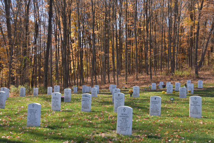
The Trace through Land Between the Lakes offers scenic picnic areas for a mid-ride break.
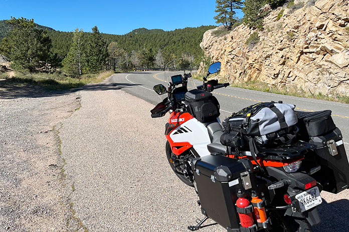
These days, I’ve become so enthralled by all the great motorcycle roads around the world and on my bucket list that I forget about the ones close to home. For this ride, I retraced steps from my early riding days with a 140‑mile Tennessee motorcycle loop around my hometown of Dover, which is located on the Cumberland River about 30 miles west of Clarksville and, as the crow flies, a little over 60 miles northwest of Nashville.
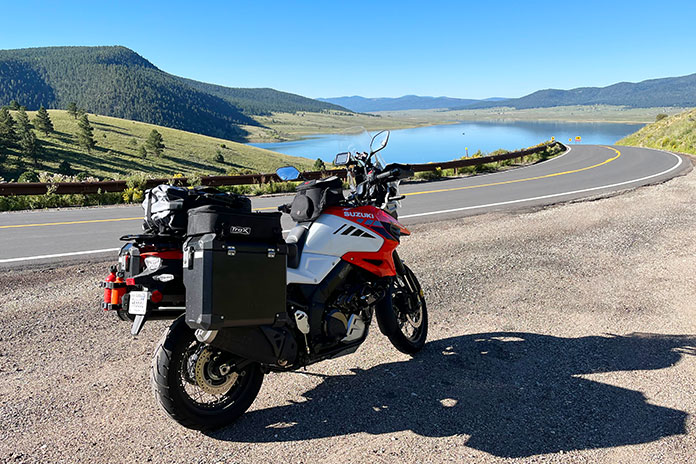
We started out at the Dyers Creek boat ramp, just across the river from downtown Dover. Then we rode across U.S. Route 79 and onto Bumpus Mills Road. This road has some of the best curves of the loop – the perfect way to get our blood pumping at the beginning of the ride.
When we got to the end of the road at the junction with State Route 120, we turned north and stopped at the family‑owned Bumpus Meals Diner. We had hoped to pop in for a bite of their handmade desserts and a cup of coffee, but the diner was closed that day as the family and staff were enjoying the Thanksgiving weekend.
My husband, Jake, and I revisited many of the roads we explored as high schoolers with fresh driving licenses.
Oh well, onwards we went. The next stretch of the ride took us into Kentucky on State Route 139. It can be tempting to pick up the speed on this road, but we knew we couldn’t get too carried away. Much of this land is farmed by Amish communities, and you never know when you’ll run up behind a horse‑drawn buggy just over the next hill.
An optional spur is to take a right on State Route 164 and visit the Oak Ridge Country Store. We love their homemade cheeses, deli sandwiches, and local canned and pickled foods. There are other stops along the road where you can purchase smoked meats, honey, fresh produce, and other goods.
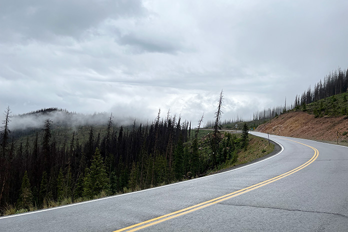
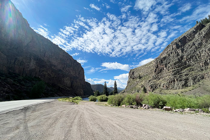
We continued our Tennessee motorcycle loop north until we came to U.S. Route 68, where we turned west for 15 miles and rode over the Cumberland River and into Land Between the Lakes National Recreation Area. We turned south at the Woodlands Trace National Scenic Byway, also known as The Trace (not to be confused with the Natchez Trace Parkway, which runs between Nashville and Natchez, Mississippi).
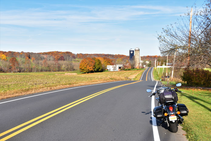
State Route 232 has nice sweepers and little traffic, allowing us to ride at our own pace without having to worry much about other drivers.
The Trace is a beautiful road that runs right through the center of LBL. Along the way are the Golden Pond Visitors Center and Planetarium, picnic areas, a bison range, campgrounds, the Turkey Bay OHV Area, and the Homeplace 1850s Working Farm and Living History Museum.
We continued through LBL and back toward Dover. At the end of The Trace, we turned west on U.S. Route 79 and popped in at Brien Dill’s Piggly Wiggly. I worked at this grocery store throughout high school and college and still enjoy stopping by to visit with past coworkers and the owner, Brien, who rides a BMW R 1250 GS Adventure and loves chatting about motorcycles.
My first employer, Brien Dill, always has a smile and loves chatting about bikes.
Down the highway about 6 miles, we turned south onto State Route 232, also known as the “Baby Dragon.” Unlike the famous 11‑mile road in East Tennessee with a similar name, the Baby Dragon doesn’t have tight, technical curves, but it has plenty of long sweepers with good visibility. By the time we got to the end of the Baby Dragon, we were getting hungry, so we stopped at Southernaire Motel & Restaurant for a meatloaf plate with turnip greens and black‑eyed peas.
Cruising down the “Baby Dragon.”
After a tasty lunch, we continued east through the towns of Stewart, Tennessee Ridge, and Erin until we got to Cumberland City, where candy‑striped steam stacks from the TVA power plant stretch up into the sky. We rode down to the ferry, paid 75 cents (tickets are $1 for out‑of‑state motorcycles), and hopped over the river.
Southernaire has an extensive menu, but you can’t go wrong with the meatloaf plate.
The last leg of this route goes through Indian Mound, the part of Stewart County where I grew up. Maybe I’m biased, but this is my favorite portion of this favorite ride. The roads through the Mound rise up over ridges and snake down along creeks and past fields of cattle. The last road is Old Highway 79, the curviest road of the loop.
The TVA power plant employs many local residents, including my dad, and the ferry just south of the plant offers a quick jump across the river.
At the end of Old Highway 79, you’ll find yourself back on U.S. Route 79 and just a stone’s throw away from the boat ramp where we began this route. Revisiting these roads and stops that have always been a part of my life gave me a renewed appreciation for my community and town. Sure, there are places in the world with more dramatic views and more exciting roads, but at the end of the day, these are the roads I’ll always come back to.
On the Black Hills BDR-X, Daniel was thrilled with the 411cc Royal Enfield Himalayan. “It’s the way to go for me as I continue to master my off-road riding skills!” (See Shad TR40 Terra Adventure saddlebags review here.)
If you’re looking for a golden adventure riding opportunity, the Black Hills BDR-X marks the spot. Backcountry Discovery Routes are adventure/dual‑sport routes that typically cover entire states and take about a week to complete, with GPS tracks and helpful info provided for free by the nonprofit BDR organization. In addition to its main routes, BDR has mapped out several shorter BDR-X loop routes that can be completed in a few days.
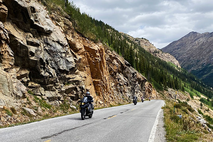
Located in western South Dakota, the Black Hills area is known for its scenic beauty, curvy roads, and historic sites like Mount Rushmore and the Crazy Horse Memorial. When most motorcyclists think of the Black Hills, they think of the Sturgis rally, which brings upwards of 500,000 people to the region every August.
The Black Hills BDR-X is a 355‑mile mostly off‑road loop that starts and ends in Keystone, just a few miles east of Mount Rushmore, and is divided into three sections. Backcountry Discovery Routes recommends riding the Black Hills BDR-X counterclockwise, but since it’s a loop, you can start and finish anywhere along the route and run it in either direction.
The presidents at Mount Rushmore represent key aspects of U.S. history: Washington symbolizes the country’s birth, Jefferson represents expansion, Lincoln signifies development, and Roosevelt signifies preservation.
What makes the Black Hills BDR-X such a perfect adventure route is its variety. The landscape includes rugged mountains, dense forests, and wide‑open prairies. The route passes through historic towns like Deadwood, Mystic, and Hill City, as well as public lands such as Wind Cave National Park and Custer State Park.
We rode into Deadwood covered in Black Hills dust just like they did 150 years ago.
There are great campgrounds or more luxurious lodging available. You’re never far from civilization, so you can get away from it all yet still have access to gas stations, stores, restaurants, and hotels. The BDR-X route includes flowing gravel and dirt roads, challenging two‑track, and some of the area’s best paved roads, including Spearfish Canyon Road, Needles Highway, and Iron Mountain Road.
Spearfish Canyon was the filming location of the final scene in “Dances With Wolves.”
Setting the Hook
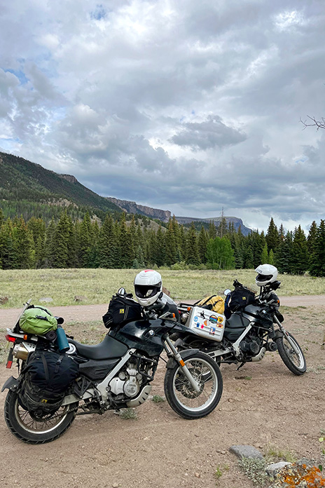
Last July, I joined three of my CFMOTO USA colleagues – Reid Strait, Daniel Dégallier, and Bill Baker – at Get On ADV Fest, a four‑day adventure‑bike rally in the Black Hills where we introduced the Ibex 800 T adventure bike. There was plenty of off‑road riding involved, and REVER provided excellent tracks for the event.
The Black Hills BDR-X is a best-of-class route. Gorgeous canyon roads. Superb gravel. Epic two-track. Majestic scenery. Native American and U.S. history. Clean, easy camping. Great food. Yup, there’s golden riding in them thar Black Hills.
The riding was so good, we were inspired to return in September and be among the first to ride the new Black Hills BDR-X. The stars aligned when we learned that Rally for Rangers, a nonprofit organization that raises funds to support park rangers, would be hosting an event in the Black Hills at the same time (see sidebar below). CFMOTO USA provided Ibex 800 Ts for the guides to use during the event, along with a Papio minibike for cruising around the campground.
The Hitch Rail Bar and Restaurant in Pringle is a great lunch stop.
After we delivered the bikes to the event, we spent the next few days riding the Black Hills BDR-X to do some team bonding. Reid rode an Ibex 800 T, but the rest of us rode our personal bikes: Bill on a KTM 690 Enduro R, Daniel on a Royal Enfield Himalayan, and me on a Kawasaki KLX 300.
There’s an old mining town at the bottom of Pactola Reservoir, which was completed in 1956.
Black Hills BDR-X: 4 Riders, 4 Bikes, 4 Days
We may have different tastes in bikes, but we all agree on one thing: The Black Hills BDR-X is fantastic. It’s 355 miles of adventure motorcycling bliss. In terms of difficulty, I’d rate it 4 or 5 on a scale of 1‑10. (I’ve also ridden the Mid Atlantic BDR, which I’d rate an easy 2 or 3.) Every day of the BDR-X was filled with moments of euphoria, which crystallized into memories that we’ll share around the campfire for years to come.
During one part of the ride, the sun overhead was radiant, casting a warm, autumn glow. The steady, gentle crunch of gravel under my tires never got old, nor did the scenery. Towering cliffs with rough textures contrasted with the vivid foliage below. The curves and bends unfurled before me, each one as breathtaking as the last. It was a sensory feast, as if Mother Nature took out her paintbrush, mixed up an impossibly diverse palette of rich colors, and painted a masterpiece. At higher elevations, the hills were ablaze in scarlet, amber, and gold, while it was a verdant wonderland down below. I was tempted to ride faster, but I slowed down, smelled the pines, and savored the experience.
Campfire quote of the night: “Motorcycles are like beer. The best one is the one in your hand.”
Black Hills Gold
If you love off‑road adventure riding, you’ll love the Black Hills BDR-X, which was like discovering a vein of gold. There’s gravel, rocky two‑track, mud, and epic pavement. There’s majestic scenery, wildlife, and history. You can’t see and do it all in one trip, so like the four of us, you’ll want to come back. It’s fun but by no means a stroll in the park, and it’s the difficult stuff that sticks with you for a lifetime.
Get the best zip ties money can buy; you’ll be glad you spent the extra quarter.
On Day 3, it was raining, and we opted to do the optional hard section over Bear Mountain. The route was rutted, rocky, steep two‑track. The slick mud packed up on our tires, turning them into Teflon‑coated slicks. Bill christened this spur route “Axle Grease Alley.” On the final bit, I chose my line and went for it, twisting the throttle to the stop, desperate for the tires to hook up, every muscle in my body fighting to keep me and the Kawasaki upright. After I made it to the top, Reid gave me a thumbs‑up and said, “Brad, you looked like a flailing Kool‑Aid man. Next time keep your feet on the pegs!”
Climbing Bear Mountain in the rain took its toll on the KTM’s 17,000-mile clutch, which gave up the ghost short of the top. Bill had just enough bite left to make it to camp.
Happily, we all made it through the toughest sections in one piece. Despite the struggle and the chaos, even with our bikes and bodies caked in mud, we were grinning from ear to ear. Daniel’s quick thinking led us to a car wash in Custer, where we pressure‑washed our bikes and could again recognize which was which. Cost? A few quarters. Memories? Priceless.
BDR-X Section 3: If the trails are muddy, there are two ways to reach the Bear Mountain lookout tower: the “Hard Way” and the “Not Today” way. If it’s dry as July and the dust is flying, no problem.
Rally for Rangers Sidebar
The mission of Rally for Rangers is “to protect the world’s special places by empowering rangers around the world with new motorcycles and equipment.” It has provided more than 160 motorcycles and equipment for rangers in parks in distant places like Mongolia, Argentina, Nepal, Bhutan, Peru, and Namibia.
The first Rally for Rangers USA event took place last September in South Dakota’s Black Hills National Forest and Pine Ridge Reservation. Fifteen adventure riders raised nearly $40,000 before convening in Custer State Park for a weekend of camping, riding, visiting tribal park rangers, and donating equipment and funds to protect parks and forests.
Traditional Rally for Rangers events are two‑week international journeys, but the USA rallies are held over a long weekend. The Black Hills event donated night vision optics for tribal rangers of the Oglala Sioux Parks to conduct nighttime anti‑poaching patrols. A donation was also made to the Forest Service motorized trails program to support motorcycle‑only trails in the Black Hills National Forest.
On our third day, we met up with Rally for Rangers. It was a night to remember that included amazing food, a meet-and-greet with the Oglala Sioux rangers, and ideal camping conditions in Custer State Park.
Riders in this inaugural event hailed from all over the U.S., with some trailering their bikes and others renting from Rogue Moto or using demo bikes provided by CFMOTO. The weekend included off‑road training by Heavy Enduro as well as on- and off‑road riding on Needles Highway, portions of the Black Hills BDR‑X, and otherwise inaccessible trails on the Pine Ridge Reservation hosted by the Oglala Sioux rangers.
The Black Hills Rally for Rangers event takes place again in September 2024 to support Oglala Sioux and Northern Cheyenne tribal rangers. For more information, visit the Rally For Rangers website or listen to our interview with Rally for Rangers co‑founder Tom Medema on the Rider Magazine Insider Podcast.
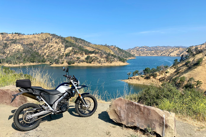
Lake Hennessy and Lake Berryessa highlight the northern arc of this spectacular loop ride through Sonoma’s hill and wine country.
This is a tale of two amazing rides. One threads its way through some of Northern California’s beautiful wine, lake, and hill country. The other winds its way through my very being to the center of my heart.
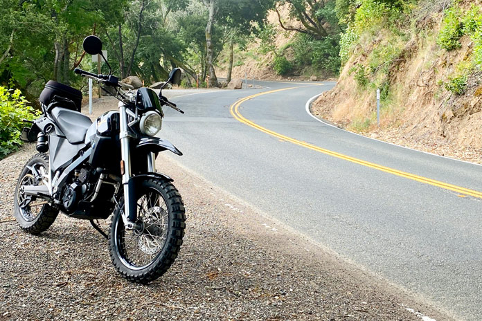
Recently, my wife and I traveled to California’s Sonoma wine country to attend a ceremony in which our son‑in‑law, Lt. Col. Joffre Lander, assumed command of a squadron at Travis Air Force Base. Since I don’t like to be far from a motorcycle when traveling, I took my BMW G 650 X‑Country along for the trip.
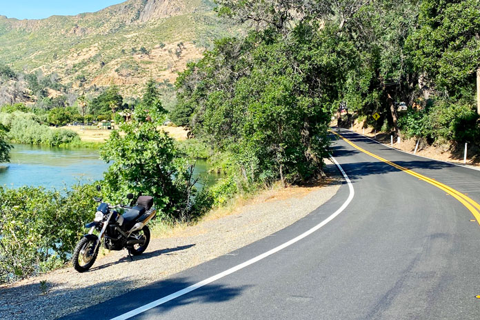
Sonoma’s backroads trace beautiful paths through rolling hills.
A Wine Country Loop
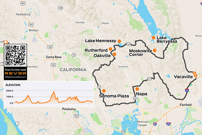
During a lull in the military and familial activities, I snuck the BMW out for a loop ride through the golden hills and grapevine‑lined terrain in the Sonoma region. I rolled out of Vacaville on Interstate 80 to reach the sweeping corners of narrow, scenic Wooden Valley Road, which is lined by trees and passes through rolling grasslands and vineyards.
The turn onto State Route 121 provided even more varied terrain as rock outcroppings added texture to the ride. Various wineries staked their claims with stone archways and beckoning signage. As SR-121 morphed into State Route 12 on my approach to the town of Sonoma, the density of wineries increased.
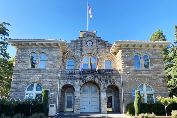
When I threw down my kickstand at Sonoma Plaza, I had no idea of the historical significance of the town of just over 10,000 souls. Across the street from the beautiful centerpiece park rests the Sonoma State Historic Park, which is a cluster of historic sites. It’s an open and easy stroll through locations like the Mission San Francisco Solano, Sonoma Barracks, Toscano Hotel & Kitchen, and other fascinating buildings.
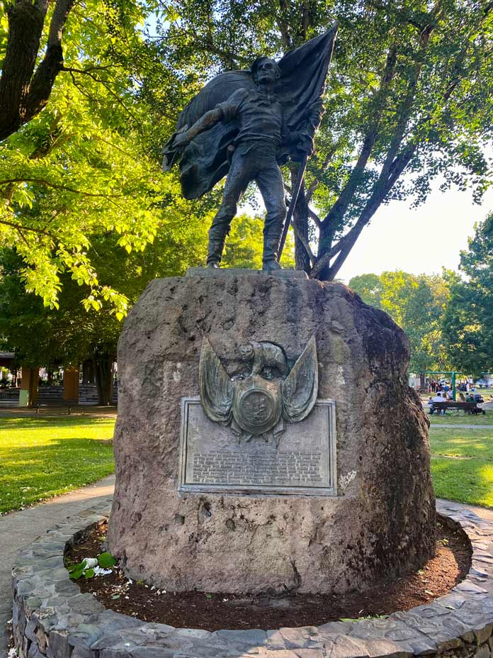
After walking back to the vibrant green shade of the 8‑acre Sonoma Plaza, I stood in the shadow of the impressive Bear Flag Monument, which commemorates the spot where the Bear Flag Party raised the Bear Flag and declared California free from Mexican rule in 1846. After a walk around Sonoma City Hall in the center of the plaza, I continued my clockwise loop ride.
The Bear Flag Monument honors a significant moment in California history.
SR‑12 led me to Trinity Road and other narrow, winding byways that are thoroughly entertaining, curvaceous rolls beneath trees, beside cliffs, and over hills, often with panoramic views.
After passing through Oakville and Rutherford, I headed farther east on State Route 128. This stretch was arguably the most beautiful part of an already spectacular ride. I rolled past Lake Hennessy, Lake Berryessa, and several family wineries. Finally, I headed south back to Vacaville and to my daughter’s home. Would this be the end of my tale? Hardly.
Sonoma City Hall is the centerpiece of Sonoma Plaza.
A First Long Ride
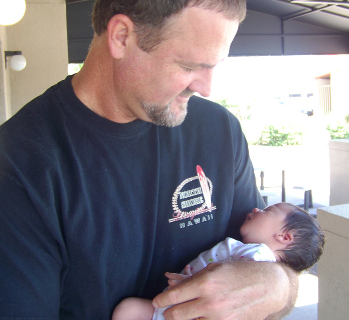
In 2011, I welcomed my first granddaughter into this world. I vividly remember the overwhelming love I felt when I held little Skya for the first time. The tiny black‑haired treasure in my arms was so perfect and so lovely that I was instantly and indelibly smitten.
Over the dozen years since she was born, I have taken Skya on many short motorcycle rides around the yard or the block with her planted securely in front of me on the saddle. She has grown from a fragile cherub to a vibrant, smart, lovely pre‑teen, and motorcycle rides have been a vital part of our deep and loving connection.
The author’s granddaughter captured his heart from the first moment he held her.
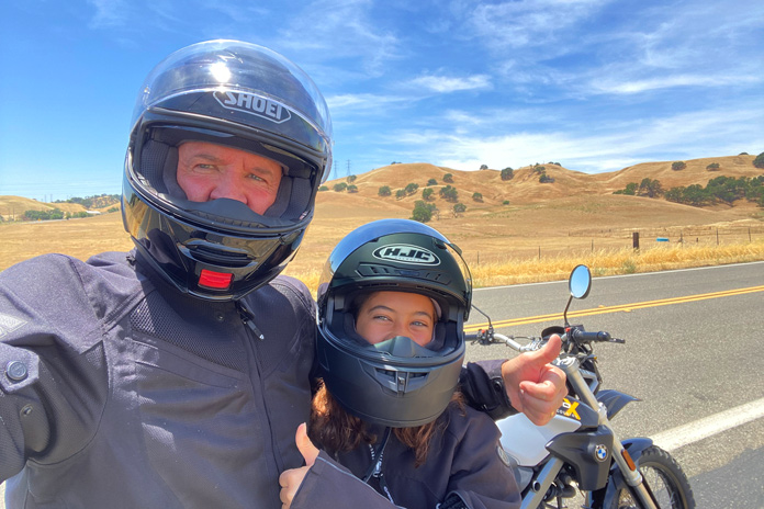
On this occasion, Skya was waiting when I rolled into my daughter’s garage. As we sat and talked, it became clear she was ready for her first longer motorcycle ride. Parental permission was secured, and I fitted Skya in my wife’s riding gear. We discussed what it takes to be a safe and secure passenger on the back of a motorcycle.
With a wave to her mother and grandmother, Skya and I headed north for a loop ride. Almost instantly, she found the groove and became a settled “sack of potatoes” on the back of the BMW. The repeated portion of my earlier route took on a new significance as I could feel the wonder Skya was experiencing. She would occasionally tap me to point things out, and as we flipped up our faceshields to talk, I could see the joy in her green eyes.
Full-face helmets can’t hide the joy on those two faces. A “favorite ride” indeed!
We stopped often to decide on routes, take in views, and just chat. At one stop, I pointed out the smooth, pale hills on the horizon. I mentioned that they reminded me of Hills Like White Elephants, a short story by Ernest Hemingway, and I recommended that she read it someday. Back on the motorcycle, Skya chose the routes, including a long road to a dead end that gave us both a laugh.
I have ridden thousands of miles in my lifetime, and the miles that Skya and I shared that day are some of the most significant. We agreed that when she gets a few more years under her belt, we will reconvene for an extended ride. We can’t wait.
The nimble BMW G 650 X-Country was the perfect mount for the curvy sections of the route.
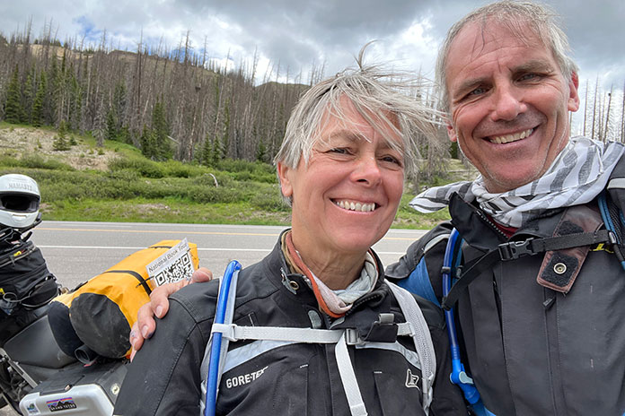
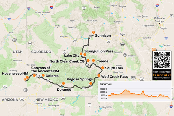
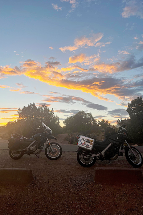
C. Jane Taylor’s moto memoir Spirit Traffic was published in 2022. That summer, she and her husband embarked on a 97‑day cross‑country book tour on their BMW F 650s. She said her book tour was characterized by deeply rewarding and completely exhausting work. It also featured great roads. During her vacation from what some might already consider a vacation, she enjoyed many memorable rides. The leg from Gunnison, Colorado, to Hovenweep National Monument in Utah was a favorite. –Ed.
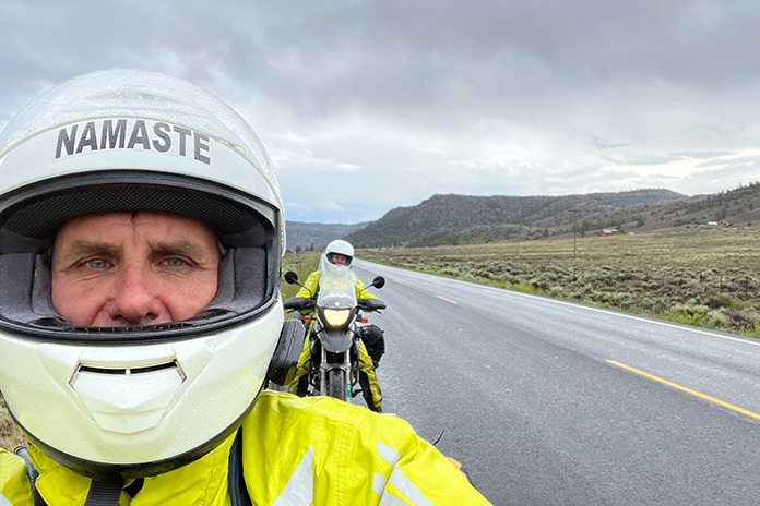
My husband, John, and I rode for 97 days – from Maine to California and back to Vermont – on a national book tour in the summer of 2022. We snapped this selfie at 10,856-foot Wolf Creek Pass in Colorado.
West of Gunnison, Colorodo, U.S. Route 50 was closed. We’d seen signs about the closure for at least 100 miles. Those signs were for other people, right? We’d planned to stay on the famous Colorado byway through the Grand Mesa, Uncompahgre and Gunnison National Forests as long as we could. But as we approached Gunnison, our shoulders slumped with the reality that the signs were for us. We’d have to rethink our whole route. And the weather was starting to look iffy.
At the Gunnison County Chamber of Commerce, a note taped to the door underscored the closure. We went inside, paper roadmap in hand. At the desk, the clerk proffered her own map, opening it in front of us. She and John pored over it like kids seeking clues to lost treasure.
She confirmed that U.S. 50 was closed and suggested State Route 149 instead. It had less traffic and was more beautiful, she assured us. We compared her map to the Butler map for the region. (Butler Motorcycle Maps highlight the best roads, rating them on twisties, traffic, road surface, etc.) SR‑149 was G1 (gold), Butler’s highest rating – perfect!
After filling our water bottles, we headed to the gas station. SR‑149 is quite rural, so we wanted to be prepared. As John filled our tanks and I surveyed the darkening skies, a bolt of lightning ripped through the clouds. Thunder crackled. A guy next to us gassing up his pickup was watching too.
“Hope you’re not going that way,” he said, nodding toward the storm.
“Not anymore,” I said.
We paid for our gas as the storm clouds gathered closer and closer. Thunder rumbled, and lightning struck from cloud to ground in the near distance. We sped back to the park next to the Chamber and ran for the cover of a gazebo. Just as we stepped under, buckets of rain dumped from the sky, and lightning dashed all around us. The thunder was so loud that we ducked our heads each time it clapped.
John snaps another selfie on SR-149 along the Lake Fork River. As two cross-country-and-back trips have taught us, body temperature management in variable conditions demands a good rainsuit – and a good attitude.
Celebrating our excellent timing, we stretched out to nap on top of the picnic tables just as two vans arrived and disgorged two dozen kids. It was the local mountain‑biking camp escaping the weather. We were instantly surrounded by kids eating popsicles and playing a raucous game of tag. Now each thunderclap was accompanied by the ear‑piercing screams of prepubescent mountain bikers. One of the camp counselors checked in on our welfare, asked about the bikes, and offered popsicles, which we accepted.
The lightning eventually abated, though the rain drizzled on. The camp counselors packed their charges and drove away. We wrestled into rainsuits and got back on the road.
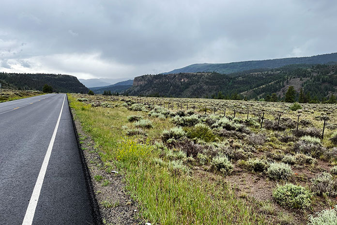
SR‑149 was as wonderful as described: a narrow, almost abandoned two‑lane road snaking seductively through the San Juan Mountains and the Rio Grande National Forest. The weather was cold and drizzling, but the road was curvy, and the air smelled like earth and springtime in New England. We were in motorcycle heaven.
Ten miles down the road, oncoming cars flashed their headlights, gesturing to slow down. Thinking they were trying to warn us about a cop, I laughed. It had taken me five years to get up to the speed limit. We continued with caution until a mudslide stopped us in our tracks. If we hadn’t been wearing helmets, we would have scratched our heads in a “Now what?” gesture. Like U.S. 50, it seemed SR‑149 would soon be closed too, but we gingerly traversed the shallow edge of the slide at the far‑left side of the road. Alert to the changes in road surface and rambunctious streams in the gullies flanking the road, we pushed forward like children anticipating candy at Halloween.
SR-149 near Powderhorn, Colorado.
Instead of candy, we sought groceries as we rolled into Lake City and its tiny country store whose proprietors seemed to be a badly mismatched couple. The woman in long braids glared at us as if we’d tracked mud onto her freshly mopped floor, while the man – handsome in a Willie Nelson kind of way, if Willie Nelson could be considered handsome – happily greeted us, teasing about our florescent green rainsuits. “We are not men, we are Devo,” he joked in a robotic voice referencing the ’70s New Wave band famous for their quirky spaceman costumes. We bought vegetables, tortillas, and cheese for quesadillas we would cook once we found a campsite for the night.
Lake City is an eye‑blink of an old mining town with the down‑at‑heel aspect of a climate-change ski resort in shoulder season. The cold, damp weather did not bring any charm to the Grizzly Adams cabins lining the road.
I attributed the town’s creepiness to its horror‑movie sepia tones and bad weather, but I later learned that Lake City gained notoriety in 1875 when Alferd Packer, the “Colorado Cannibal,” was charged with killing and eating the prospectors he’d been hired to guide through the San Juan Mountains after the group had become snowbound. In the spring, five bodies with human teeth marks were found at the foot of Slumgullion Pass. Lake City’s Hinsdale County Museum has an extensive collection of Packer memorabilia, including a skull fragment from one of his victims and several buttons from the clothes of the five men he ate. The area where the bodies were discovered is now known as Cannibal Plateau. Odder still, the area hosts an annual Alferd Packer Jeep Tour and Barbecue.
As we approached the peak of Slumgullion Pass near Lake City, Colorado, the rain abated, and the skies cleared.
My unease was supplanted by the fear and exhilaration of climbing out of town along steep, wet switchbacks to Windy Point Observation Site and Slumgullion Pass. As we climbed, I chimed into the headset, “Don’t look right, Johnny.” The narrow two‑lane highway had no guardrail, and the drop-off induced a vertigo that made me tighten my grip on my handlebar and tank. At Windy Point, we stopped to look back at the long narrow valley thousands of feet below us.
Evening was approaching, and we were still in the middle of a sheer climb on our way to North Clear Creek Campground, a destination we were not sure even existed, but the sky finally opened, and the tight switchbacks loosened as we topped 11,530‑foot Slumgullion Pass.
The map we consulted – and re‑consulted – showed the campground within 50 miles. Trying to keep from being swept up in the National Geographic beauty of the broadening landscape, I kept my eyes peeled for a Forest Service campground sign. We were hungry and cold, and it was getting late. We’d passed so little traffic, I was game to pitch the tent at the side of the road, but John persisted.
North Clear Creek Campground in Colorado’s Rio Grande National Forest was our home for the night after an eventful ride.
We finally turned off SR‑149 and crossed a cattle guard onto Forest Road 510, which fell away to vertiginous Class‑IV switchbacks. I groaned but also laughed. It was the “dropping hour.” We have a joke that on extended motorcycle trips, we often face the most challenging miles of the day right before arriving at our destination exhausted and hungry. The road toyed with us. I inched down its sharp gravel turns, determined but cautious given the hour. As I eased down one hill, a young woman on a dirtbike blasted up it. Encouraged that there might be an actual campground ahead and inspired by another woman on a bike, I sped all the way up to 2nd gear!
Pink sunglasses reflect the expansive valley near Creede.
After almost missing the 70‑degree turn into the campground at the bottom of the hill and duck‑walking the bikes back over sandy gravel ruts, we casually rolled into the nearly vacant campground and found a suitable spot with a picnic table, breathtaking panoramic views, and a glorious sunset reflected off the peaks of the Rio Grande National Forest.
The next morning was cold and clear. With visions of coffee and pastries dancing in our helmets, we headed toward Creede, home to an underground mining museum, the Mineral County Landfill, a cemetery, a chapel, and an excellent little food truck/coffee shop that appeared to be set up during the pandemic like a one‑way street, with one entrance and one exit. The pastry case was filled with buttery French confections, the air with the scent of espresso. Bon appétit! We took our pastries to a table outside where we lounged, sipping cappuccinos in the sun.
The population of Creede, Colorado, swells from 300 to 10,000 on July 4th. After a cold, wet, challenging ride the day before, it was an oasis. We found a mobile coffee shop where we enjoyed the company of locals, pain au chocolat, and cappuccinos in the sun.
The road along the Rio Grande – which far downstream serves as the border between Texas and Mexico – was as good as the croissants. At South Fork, we headed south on U.S. Route 160 and climbed to 10,856‑foot Wolf Creek Pass. It was cold at elevation, and we encountered traffic and threatening weather, but the road was smooth, wide, and curvy through Pagosa Springs and Chimney Rock. We lunched in Durango after a torrential downpour trapped us under a busy highway underpass.
U.S. 160 through the mountains near Hesperus Ski Area was fabulous despite the cold and wet. Things got warmer as we descended out of the mountains, and by the time we got to Mancos, we were sweltering in the heat of the desert. We took off as much as we could and poured cold water down the backs of our armored jackets. Body temperature management was a challenge we had improved at over time.
South of Creede, the Rio Grande snakes along SR-149 on the way to South Fork.
In the blazing heat, we headed west on State Route 184 toward Dolores, then north on U.S. Route 491 past Yellow Jacket and into Canyons of the Ancients National Monument, administered by the Bureau of Land Management and inhabited almost solely by spirits. The road narrowed and then narrowed again. There is something gritty and fundamental about these small roads, something secret and unspoken like the second indents of an outline of one’s life or the dark side of the moon.
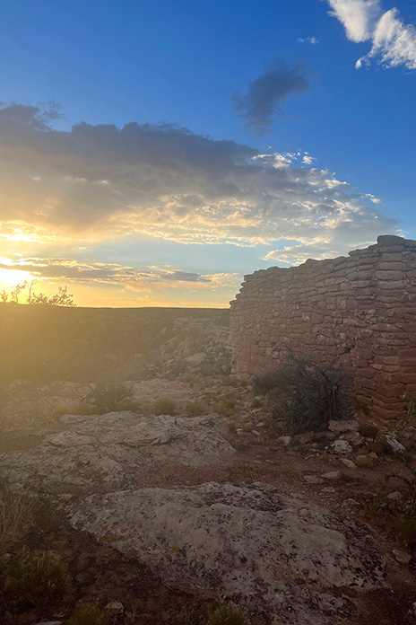
The heat kept building. As we crossed into Utah, the landscape gave way to a barren, flat emptiness without trees or buildings. We traveled in silent awe, feeling exposed in the heat but excited about the ruins of Hovenweep National Monument.
Our day took us from cold rain and high passes to sweltering heat and desert valleys. The sunset at Hovenweep was a just reward.
Known for six groups of Ancestral Puebloan villages, Hovenweep contains evidence of occupation by hunter‑gatherers from 8,000 B.C. until AD 200. We were finally going to visit the spirits we’d been sensing on this hot road.
We turned into what seemed the middle of nowhere, but John assured me this was the way. I saw only shrubs, grasses, and sage until I glimpsed a sign the size of a sheet of paper with an arrow proving him right: Hovenweep National Monument. We traversed a lunar landscape of sand, craters, dead volcanoes, and lava flows until we happened upon a herd of wild horses in the middle of the road. We stopped to gape. Shy and beautiful, they paused in their grazing to examine us. Though I wanted to join these beasts on a romanticized journey out of a dream, we had to keep moving. Standing still in the late afternoon heat was a torture neither of us wanted to endure – magical, wild horses notwithstanding.
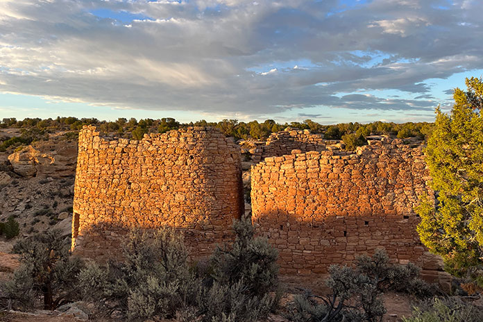
Sunset on the ruins at Hovenweep National Monument in Utah.
Reminiscent of Death Valley with its lethal sun, long straightaways, and distant bluffs, Hovenweep Road also reminded me of the song by America “A Horse with No Name.” I started to understand the line “In the desert, you can’t remember your name.” In the heat and arid sameness of the landscape, time seemed to stop. I could tell we were moving, if only for the visual cue of the scenery receding in my mirror. I became flooded with the eerie sensation of being watched. It felt as if the ghosts of millennia were hovering just above the heat waves upwelling from the macadam.
“Hovenweep” is a Paiute/Ute word meaning “deserted valley.” As we rode into the scorched campground, I sensed that the ancestors were still there. A clan of attentive ravens seemed to be protectors – or just eager to see what food they could liberate from us.
Hovenweep is a special place, and we had the distinct feeling that the ancestors were still there.
After pouring rationed water onto our heads and down our backs, we hiked off to see the ruins, following a faint path between rock walls leading to a dry creek bed. Walking fast to beat the setting sun, we climbed down into the creek bed then up the other side until we saw what looked like a crumbling brick silo. Hovenweep at last! As we gazed in silence at the majestic ruins of a once‑lively community, a rainbow broke through distant storm clouds. Back at our campsite, we cooked dinner in the waning light as a million stars began to wink.
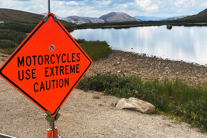
Independence Pass is one of the truly iconic motorcycle roads in the Southwest and a great reason to take a Colorado motorcycle trip.
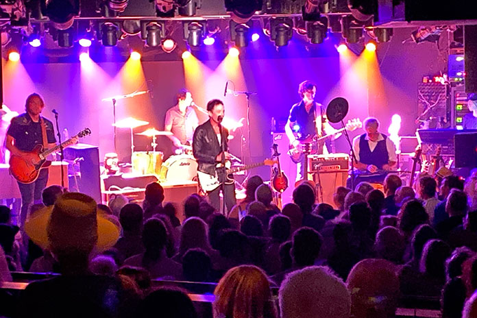
As I sat in the fantastic Belly Up Aspen concert venue in Colorado listening to a great performance by The Wallflowers, I did not imagine that “belly up” was a condition I was going to have to actively avoid the next day. You see, the following morning I was going to ride Independence Pass, one of my favorite stretches of pavement in the Southwest that I had taken some months previous in the fall.
That night in Aspen, Wallflowers front man Jakob Dylan was on top of his vocal game and filled the intimate venue with all of his best work. Ironically, the band’s song Angel on my Bike chronicles salvation from either a real or figurative motorcycle crash. Turns out I was going to need that angel on my pillion seat.
The Wallflowers offer up a lyrical reminder for safe riding,
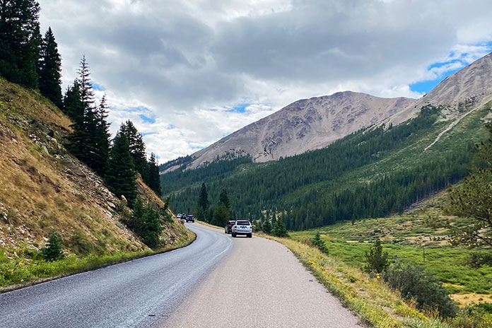
The crisp Colorado mountain air had me zipping up my jacket vents as I started the ascent out of Aspen. The early ride was just what I had hoped for. Smooth pavement traced through the evergreens, and traffic was light. I quickly fell into that perfect groove as I slalomed up toward the pass.
I was only a handful of miles into the climb when I got the first hint that this would not be a normal ride. Just after a blind curve, a mother moose and her offspring bounded in front of me. The mother was quick and agile as she leapt to safety. The little one was confused and halting, and I was forced into an abrupt evasive swerve. As my heart settled, the two disappeared into the forested depths.
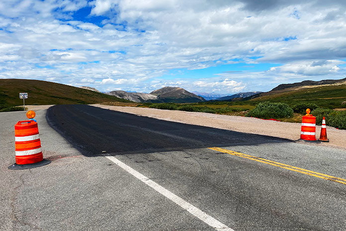
As I continued my climb, that smooth blacktop transformed into recently applied chipseal. The tar-coated gravel began the telltale cacophony of sounds as it flung from my tires onto my fenders and bodywork – a far cry from the melodic offerings of The Wallflowers the night before. I cut my speed in half and made the requisite adjustments to my cornering technique.
The crest of the pass marks the dividing line between fresh roadwork and weathered tarmac.
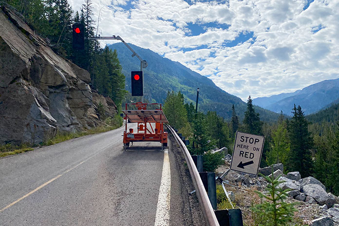
I rode up to one of the two stop lights on the pass that control traffic in the one-lane Narrows sections of Independence Pass. The light was just changing to red, and I slowed to a stop in anticipation of the oncoming traffic taking its turn in the Narrows. In my mirrors, I saw an SUV barreling toward me. I was already planning my escape maneuver in what little room I had on the side of the road. Without any slowing, the Range Rover barreled into the oncoming lane and passed me, pelting me with gravel as he ran the red light and endangered me and all of the potential oncoming traffic. Close call No. 2, plus challenging riding conditions.
Narrow road conditions on the pass require metered traffic flow for the law-abiding drivers.
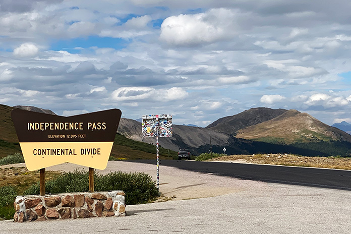
After continuing on when the light turned green, I came upon the crew applying the chipseal. At this point, the road became even more challenging as the surface was newly applied. One lane was gravel and the other was fresh tar. The combination of this variable surface with the twisty, guardrail-less pass made for tricky riding. Accelerating, braking, and turning all had to be muted and modulated. The road remained like this all the way to the 12,000-foot apex of the pass.
These warning signs mean business in the Colorado mountains.
Fresh tar and fresh chipseal make for unpredictable riding surface conditions.
After stopping for the views – and the bathroom – at the top, I started the descent on the other side of the pass on established pavement with actual markings and no gravel or fresh tar. It was not, however, the end of the challenge.
Independence Pass has some of the best views in Colorado, so slow down and make it there.
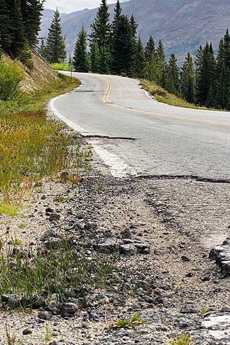
It became clear that the prior winter had taken a toll on the pass, which had been much more intact only months before in the fall. While not as challenging as the way up, the frayed and crumbling margins of the tarmac and the potholes made the descent worthy of extreme vigilance.
The descent down the mountain pass shows why there is a need for summer maintenance.
Extreme winter conditions in the Rockies make vigilant road maintenance a necessity.
In the end, I made it unscathed (other than tar on my boots and a few chips on my BMW bodywork). I did not end up belly up, maybe due in part to an angel on my bike. Now that I’m on the other side of this particular Colorado motorcycle trip, I highly recommend catching a concert at Belly Up Aspen, attending a show by The Wallflowers wherever they might be playing, and avoiding assumptions about a favorite road based on the last time you rode it.
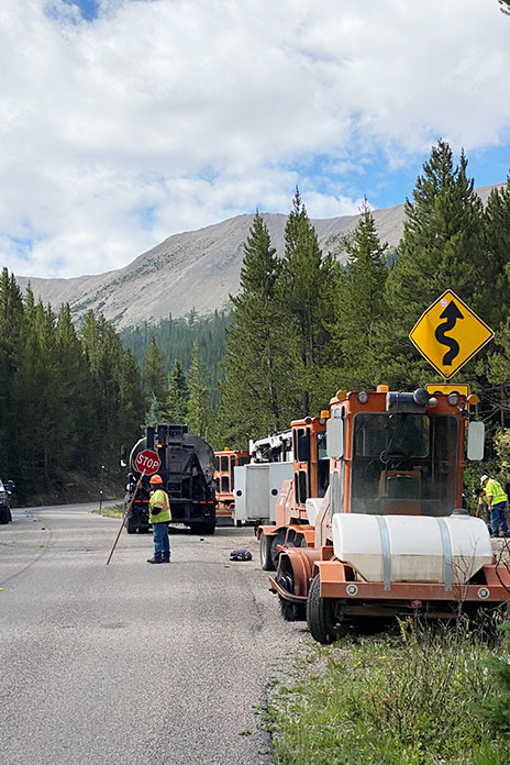
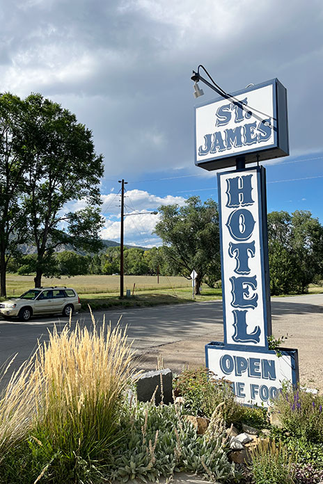
After a long, hot day riding through Oklahoma and Texas, I arrived at the St. James Hotel in Cimarron, New Mexico, the first stop on my motorcycle tour of haunted hotels. Built in 1872 by Henri Lambert near the Santa Fe Trail, it had a saloon, a restaurant, and guest rooms where many famous – and infamous – people stayed over the years.
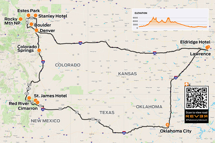
It’s always fun to have a theme for a motorcycle tour, and my plan for a late August ride was a four-day loop from my home in Oklahoma to visit three historic hotels that are widely purported to be haunted. The first would be the St. James Hotel in Cimarron, New Mexico, followed by the Stanley Hotel in Estes Park, Colorado, and finally the Eldridge Hotel in Lawrence, Kansas. Between the fright nights, I’d ride first-class mountain roads on a nearly 1,900-mile route through five states.
To make time, I rode west on Interstate 40 for the first 150 miles or so. Wind turbines were spinning at a good clip, and flags at roadside businesses whipped around in the hot wind. I rode in what my buddies and I call “the I-40 lean” – riding with the bike pitched a few degrees to the left to counteract the constant gale.
It was nearly 100 degrees when I crossed into the panhandle of Texas, and the empty landscape was dotted with cattle and oil wells. When I stopped in Dalhart to refuel, a guy with long hair and a shaggy beard pulling two Harleys on a trailer behind a pickup asked where I was heading. After I shared my plan, he said he was heading home after riding many of the same roads.
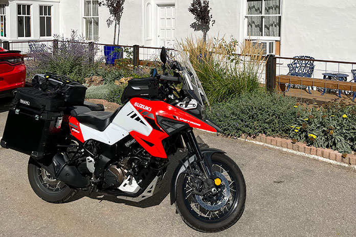
Eyeing my Suzuki V-Strom 1050XT, he said he still owns a KTM he bought back in the ’90s when he was in Germany. “I spent three years there myself,” I said, “when I was in the Army.” Turns out we were stationed in some of the same places, decades ago, on the other side of the world. And here we were, on a sweltering afternoon in small-town Texas, talking motorcycles and swapping memories.
St. James Hotel
The site of at least 26 killings, the St. James Hotel has a reputation for being haunted.
The temperature subsided a bit after crossing into New Mexico, where I rode through high plains grassland. North of Springer, I continued west on State Route 58, climbing into the foothills of the Rockies. Once in Cimarron, I parked in front of the St. James Hotel. Walking into the lobby felt like going back in time to the Old West of the late 1800s.
Built in 1872 near the Santa Fe Trail and originally known as Lambert’s Inn, this hotel was a favorite of Old West legends such as Wyatt Earp, Doc Holliday, Buffalo Bill Cody, Annie Oakley, Jesse James, and Billy the Kid.
During the lawless days of the Wild West, the hotel was the site of at least 26 murders; bullet holes are still visible over the bar in the hotel’s main dining room. Today, the St. James has 12 restored rooms in the original building, each named for a famous guest who stayed in the room, and 10 more rooms in a modern annex.
Several ghosts have been identified by paranormal experts in the St. James. Room 18 is off-limits because it is believed to house the malevolent ghost of Thomas James Wright, who was murdered after he won rights to the hotel in a poker game. The spirit of Mary Elizabeth Lambert, wife of the hotel’s founder, is said to be a protector of the hotel. She died there in 1926, and some say her rose-scented perfume still wafts through the hallways. There have been reports of a persistent tapping sound in Room 17, the mysterious smell of cigar smoke even though the hotel is nonsmoking, and sightings of a mischievous ghost resembling a little old man, nicknamed the “Little Imp,” who supposedly steals and relocates objects.
I stayed in the Pancho Griego room in the old building. Griego, a card dealer and local enforcer, picked a fight in the hotel’s saloon with gunslinger Clay Allison over the killing of Griego’s nephew. Unfortunately for Griego, he was a little (or a lot) drunk and took a bullet to the head from Allison’s gun. Would Griego’s restless spirit pay me a visit?
After a nice dinner in the hotel restaurant, I turned in. I’ve stayed in supposedly haunted hotels all over the country going back at least 20 years, and I’ve never had a paranormal experience. But at the St. James, I was awakened at 3 a.m. – the so-called “witching hour” when the spirit world is said to be most active – by an unidentifiable foul odor that defied explanation (no, it wasn’t me).
A Motorcycle Tour on the Enchanted Circle
Welcome to New Mexico’s Enchanted Circle Scenic Byway. Just outside Cimarron Canyon at 8,200 feet, picturesque Eagle Nest Lake is an introduction to the beauty of the New Mexico Rockies.
Continuing west on U.S. Route 64, I enjoyed flowing curves and yellow wildflowers as I rode through Cimarron Canyon State Park. Climbing out of the canyon revealed Eagle Nest Lake, an alpine lake above 8,000 feet near the Enchanted Circle Scenic Byway.
Turning north on State Route 38, I followed the byway toward the ski town of Red River. I knew this stretch of highway from many ski trips there with my wife and kids. The road meanders through the mountains, winding its way up to 9,820-foot Bobcat Pass and into Carson National Forest. Memories of those family trips rushed back – the cabins we stayed in, our favorite ski lifts and runs, the restaurants we liked, and the fun we had.
Crossing into Colorado, I rode over 9,426-foot La Veta Pass on U.S. Route 160 and then up through Colorado Springs and Denver. At Loveland, I turned west on U.S. Route 34 and enjoyed a winding ride through Big Thompson Canyon and Roosevelt National Forest to Estes Park.
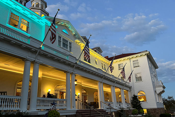
After a 400-mile day, I arrived at the Stanley Hotel, which sits on a sprawling property with views of the city that serves as the gateway to Rocky Mountain National Park. When it opened in 1909, it rivaled the finest hotels in America. It was established by Freelan Stanley, who, along with twin brother Francis, co-founded the Stanley Motor Carriage Company, which manufactured steam-powered automobiles from 1897-1924. Freelan fell in love with the Estes Valley, in part because he believed the area helped restore his previously failing health. Early hotel guests were impressed by features such as electric lights, telephones, modern bathrooms, a uniformed staff, and a fleet of Stanley Steamers.
By the 1970s, the hotel was struggling but got a shot in the arm when it became known as the inspiration for Stephen King’s bestseller The Shining. The book may be fiction, but there are plenty of real-life ghost stories swirling around the Stanley.
Darkness gathers at the Stanley Hotel. Opened in 1909, it famously served as the inspiration for Stephen King’s “The Shining.” At twilight, the hotel takes on an air of spookiness.
After checking in, I took the vintage Otis elevator to my fourth-floor room, which was hot as hell – fitting. The front desk dispatched a service technician, and as he worked on the air conditioner, I quizzed him about the hotel’s ghostly reputation.
“Is there anything to the ghost stuff?”
“Yep, they’re here,” he said. “I had my first experience after I’d been here a few months – tapped me right on the shoulder, but there was nobody there.”
“Interesting…” I replied, feeling a little chill down my spine.
At twilight, I walked out front to admire the Stanley’s beautiful facade against the darkening sky and visit the mildly creepy hedge maze, disappointed that a frozen Jack Nicholson was nowhere to be found. Back inside, I peeked in the séance room. The place certainly looked haunted.
Although Stephen King’s frightful night was in Room 217, the fourth floor where I was staying is thought to be the most haunted part of the hotel. Guests in Room 407 have reported being tucked into bed by an invisible force, and the apparition of a cowboy has been reported in Room 428. But Room 401 is the creepiest – female guests have reported inappropriate “touching” by what is thought to be an unfriendly male ghost. After my unsettling experience at the St. James, learning about the paranormal activity that has occurred just down the hall from my room had my eyes wide open as I turned off the bedside lamp.
However, after a restful sleep undisturbed by the spirit world, I packed up and headed south on the Peak-to-Peak Scenic Byway, a beautiful, curvy mountain road that reminded me why I’m a motorcyclist. Thinking it couldn’t get any better, I was proven wrong on State Route 119 toward Boulder, which follows a burbling stream with high rock cliffs on both sides for 16 glorious miles.
The lovely, flowing curves of Colorado’s Peak-to-Peak Scenic Byway.
The fun soon came to an end, and I steeled myself for a long, hot slog on Interstate 70 into Kansas. It was well after dark and I had clocked 652 miles for the day when I arrived in Lawrence for the last stop on my ghost tour.
Eldridge Hotel
Originally built in 1855 under the name Free State Hotel, the Eldridge Hotel was burned down twice because of its role as a focal point of anti-slavery sentiment. Each time it was burned, the hotel’s founder, Col. Shalor Eldridge, rebuilt it at the same site. In 1867, it was renamed the Eldridge Hotel, and through the turn of the 20th century, it was considered one of the finest hotels west of the Mississippi River.
The Eldridge Hotel was built in 1855. It was burned down twice and rebuilt each time. Its troubled past is believed to fuel the paranormal. (Photo by Jackpendry via Wikimedia Commons)
The Eldridge Hotel also has a long history of paranormal activity. The fifth floor is thought to have a direct connection to the spirit world, with Room 506 at the epicenter. Guests have reported seeing apparitions, breath marks on mirrors, doors opening and closing by themselves, and lights mysteriously turning themselves on and off. The elevator is said to have its own ghost who erratically opens and closes the elevator doors.
I checked into Room 305, which is spacious with modern amenities, and got cleaned up. Later, I wandered downstairs and explored the lobby, bar, and basement. The Eldridge is a beautiful old hotel, and I felt the weight of its history. With that history in mind – some of it painful – I can see how the energy of the past may still be imprinted on this place.
I once again slept peacefully in the comfy bed and woke up early, anxious to get on the road home. The only possible evidence of mischievous spirits was that my television was stuck on the Hallmark Murders & Mysteries channel.
Some of the roads and stops on my Old West motorcycle tour could certainly be considered supernatural, but did the experience make a believer out of me? Until I can find a logical explanation for what happened to me at the St. James Hotel, the jury is out.
Rumbling through a kaleidoscope of woodland colors, a rider and his passenger on a New Jersey backroads motorcycle ride enjoy the curves of Clinton Road as it ambles through the Pequannock Watershed.
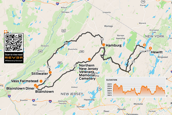
When the leaves tremble with their last days of color and the north winds begin to blow, I want to seize the day and take a ride before the snowflakes fly. I like to experience a variety of roads and sights all within the limited daylight of late fall. Northern New Jersey has great roads that ramble through state forests, around reservoirs and farms, and into small towns, making for a superb day ride.
I had plotted a route for this trip, but soon after my ride began, I saw a road sign that warned: APPLE SEASON HEAVY TRAFFIC. The last thing I wanted was to be stuck in the middle of a traffic jam surrounded by carloads of apple‑picking tourists slowly swarming toward orchards, so I threw out my itinerary and decided to go wherever the road and my gut told me.
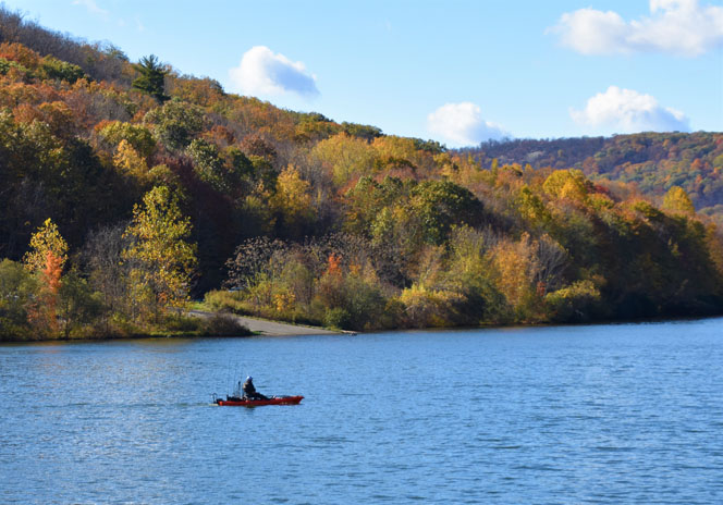
Rolling up Abram S. Hewitt State Forest’s Bearfort Ridge on the serpentine Warwick Turnpike, I avoided the congestion by taking the forest‑enveloped Clinton Road, which snakes through a large section of the 35,000‑acre Pequannock Watershed. There are four reservoirs open for public recreation, and the area is crisscrossed by mountain trails and home to all manner of wildlife.
A fisherman enjoys some peaceful solitude on one of the Pequannock Watershed reservoirs.
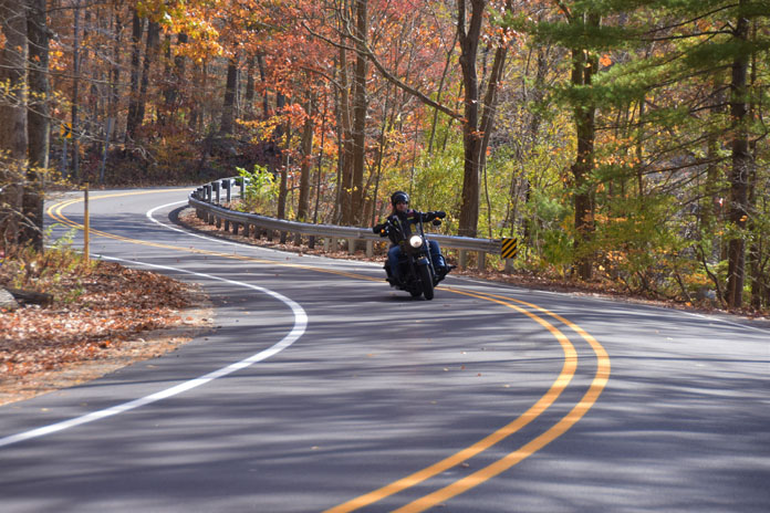
Clinton Road and its surrounding wilderness have a somewhat creepy reputation for ghost sightings, witch gatherings, weird animal hybrids, and at least one infamous serial killer. I was attracted to this particular stretch on my New Jersey backroads motorcycle ride because it was recently repaved and weaves alongside the sun-kissed reservoirs and through colorful forests, but the area’s notoriety added to its allure.
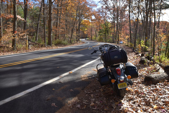
Among the fall colors, the author’s Vulcan stands ready to continue the cruise.
Several boat launches and parking areas provided opportunities to stretch my legs and drink in the scenery. Some riders are tempted to white‑knuckle it through the many twisties of Clinton Road, but I don’t recommend it. During the late fall rutting season, deer are hyperactive and as plentiful as flies on a cow patty. Besides, a slow cruise gives you time to appreciate the beauty.
However, as I turned off Clinton Road and rode west on the mostly rural State Route 23, I ramped up the pace. The crisp, pure air caressing my face was invigorating. At Hamburg, I picked up State Route 94. Rumbling south, I spotted the Northern New Jersey Veterans Memorial Cemetery and stopped to pay my respects. Walking through the cemetery, you cannot help but be overwhelmed with emotion and appreciation for those who served our country and now rest in this hallowed ground.
Headstones at Northern New Jersey Veterans Memorial Cemetery honor fallen soldiers.
Continuing south, SR‑94 passes through Newton, a bustling small town, and then into lush farmland, with New Jersey’s western mountains rising on the horizon like a fortress wall.
County Road 521 rolls through picturesque New Jersey farmland.
In Blairstown, I stopped for lunch at the Blairstown Diner, which has been family owned and operated for over 70 years and has tasty food and authentic retro decor. The diner was featured in the original Friday the 13th film, and in the hills of nearby Hardwick, Boy Scout Camp No‑Be‑Bo‑Sco stood in for the film’s major setting, Camp Crystal Lake.
From Blairstown, I wound my way north on the rolling County Road 521, stopping briefly at the scenic White Lake Natural Resource Area and the historic Vass Farmstead. Built in 1812 and listed in the National Registry of Historic Places, it is worth a stop.
The restored 19th century Vass Farmstead, now co‑owned by the Ridge and Valley Conservancy and the state of New Jersey, overlooks the White Lake Natural Resource Area.
At Stillwater, I turned left onto County Road 617 and then followed a series of other rural roads. My Vulcan handled these wavy and weaving routes through farmland and forests with cool confidence. By the time I reached SR‑23 again, the sun was hanging low in the western sky. Heading south, I cracked the whip on my Vulcan and enjoyed its pulsating power as we rode down the highway.
Leaves on the ground means riding season in New Jersey is drawing to a close.
As I exited onto the tree‑lined County Road 513, my journey neared its end. Although my route was impromptu, the ride was perfect. Cruising on great roads through the beautiful countryside during the fall reminded me what riding is meant to be: unfettered by plans and going with the flow. There definitely will be more freewheeling rides in my future. As Peter Fonda’s sage old biker character Damien Blade said in Wild Hogs, “Lose the watches.”
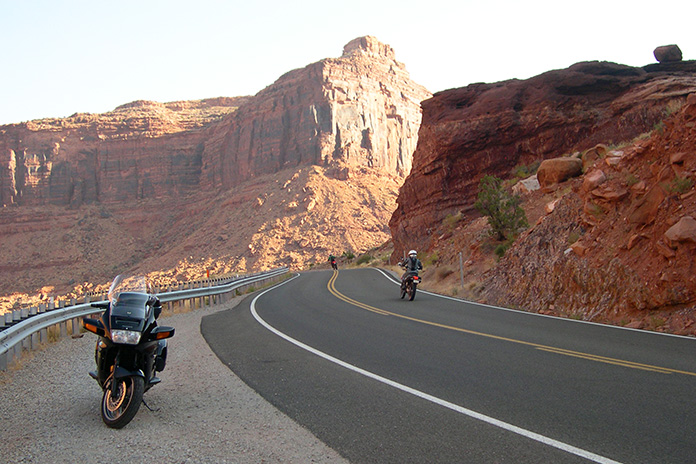
Utah State Route 128 is a scenic byway on the way to Moab, Utah, that winds through a canyon carved by the Colorado River.
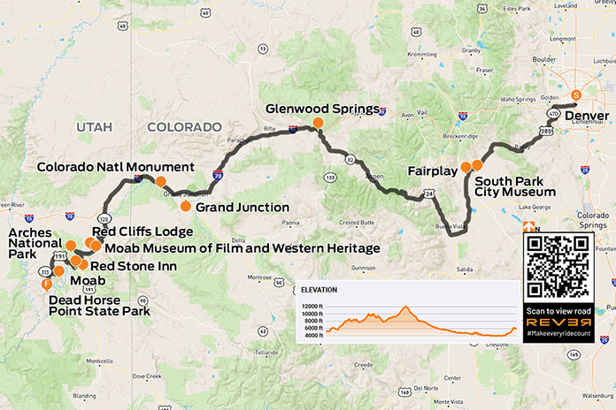
Moab, Utah, is an ideal destination for a motorcycle trip. Where else can you find sandstone arches, red‑walled canyons, snow‑capped mountains, scenic byways, two national parks, and a fun, adventure‑ready town? The best time to visit is in the spring or fall because it’s often too hot in the summer and roads can get icy in the winter.
Since I live in Denver, on the other side of the Rockies, part of the fun of visiting Moab is simply getting there. Heading west out of the city, U.S. Route 285 climbs the Front Range before passing through mountain towns like Conifer (8,277 feet), Bailey (7,740 feet), and Fairplay (9,954 feet).
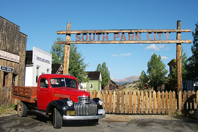
Riding through the Rockies means going over mountain passes, and on the way to Fairplay, you’ll cruise over Kenosha Pass (9,997 feet) and Red Hill Pass (9,993 feet) before descending into a broad valley. Such grand vistas across open range show the true beauty of Colorado. Fairplay is an old mining town named after the notion that all miners should have an equal chance to stake a claim. It’s home to South Park City, an open‑air museum preserving a 19th century mining town, including over 40 original buildings and thousands of artifacts from the boomtown days.
South Park City in Fairplay, Colorado, is an open‑air museum that preserves a 19th century mining town.
Continuing south on U.S. 285, the road becomes U.S. Route 24 at Antero Junction and goes south and then north through Buena Vista (7,925 feet) and Granite (9,012 feet). At Twin Lakes, turning west on State Route 82 takes you across the Continental Divide at Independence Pass (12,095 feet), where the air is thin and always chilly.
The author and his Yamaha V Star 1300 Tourer at the high point of his ride from Denver to Moab.
The long, winding descent to the ski town of Aspen is pure pleasure. SR‑82 ends at Glenwood Springs, and the next 134 westward miles follow a curving section of Interstate 70. If you have the time, I recommend the scenic Rim Rock Drive through the Colorado National Monument among the high cliffs above Grand Junction.
After crossing into Utah, take the first Moab exit for State Route 128, which is a scenic byway that winds through a majestic red rock canyon carved by the Colorado River. Highlights include the stunning Fisher Tower and Castle Rock, a finger‑like spiral to the southwest that’s been seen in many films and commercials.
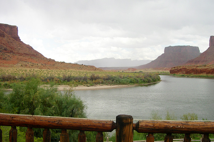
At milepost 14 on SR‑128 is the Red Cliffs Lodge, built on the old George White Ranch, another location used in many Western films. If you’re a cowboy fan like me, visit the lodge’s Moab Museum of Film and Western Heritage to see production stills, movie posters, autographed scripts, props from movies filmed nearby, and displays about Western heritage. Lunch or dinner at The Cowboy Grill is highly recommended.
View of the Colorado River from the deck at Red Cliffs Lodge, which has dining, lodging, and a museum dedicated to Western films and heritage.
The key attractions in Moab are Arches and Canyonlands national parks. Arches, located just a few miles north of town, is the more popular of the two, and the nearly 20‑mile paved road through the park takes you past a stunning array of sandstone arches, petrified dunes, and red rock formations.
Canyonlands is the largest national park in Utah, and its diversity staggers the imagination. The park is 32 miles from Moab and has 20 miles of paved roads with many pullouts offering spectacular views. The Island in the Sky sits atop a massive 1,500‑foot‑high mesa, and on a clear day you can see over 100 miles in any direction. Sunrise and sunset are particularly beautiful times of day to enjoy these panoramic views of canyon country.
Arches National Park is a wonderland of sandstone arches, pinnacles, and other rock formations. The park gets busy, so it pays to go early.
Scenic State Route 313 leads to both Canyonlands and Dead Horse Point State Park, which offers unforgettable views of deep canyons and cliffs overlooking the Colorado River. I recommend taking time to explore side trails to see different viewpoints in this one‑of‑a‑kind area.
The La Sal Mountain Loop, a 36‑mile scenic road that starts at SR‑128 near Red Cliffs Lodge and goes through Castle Valley, up into the La Sal Mountains, and then back down to Moab near Spanish Valley, is another great local ride.
One of the many awe-inspiring vistas at Dead Horse Point State Park.
Moab is an ideal base camp for lodging, dining, and other adventures such as whitewater rafting, hiking, mountain biking, and off‑road riding and driving (you can rent Jeeps, ATVs, and side‑by‑sides). One of my favorite places to stay is the Red Stone Inn, a rustic but clean and affordable motel with a communal hot tub and picnic area and rooms with a TV, free wi‑fi, and a mini kitchen.
Whether you travel across the Colorado Rockies, through the red‑rock canyons of southern Utah, or take some other route to get there, put Moab on your “must visit” list. I promise you won’t be disappointed.
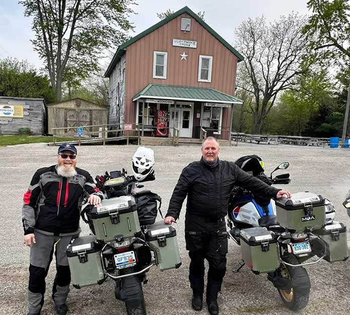
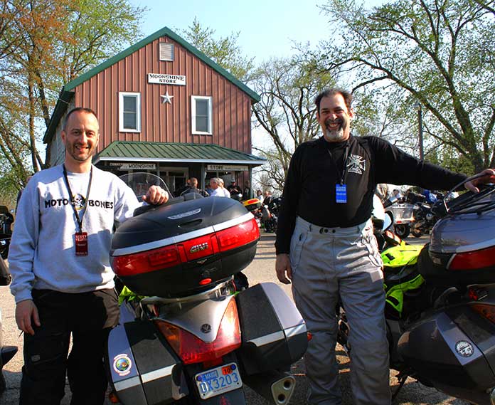
Some of the 2023 Moonshine ride-to-eat participants (left to right): Steve Efthyvoulou, Scott Williams, Chuck Smolka, Randy Bridgewater, and Michael Boucher.
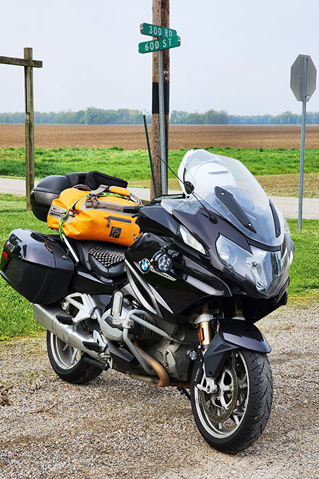
This Favorite Ride doesn’t include a route map because it’s all about a single destination: the corner of 300 Road and 600 Street in Moonshine, Illinois. Getting there is a personal experience for every rider who makes the Moonshine Lunch Run.
You may recall the story I wrote about the last official Moonshine Lunch Run, which took place on April 29, 2018. But on that day, as I gathered with other long‑distance riders outside the Moonshine Store, munching my Moonburger under a cool Illinois rain, I sensed it wasn’t the end.
The original concept for the MLR, conceived by our late farmer friend Terry Hammond, just required folks to ride from somewhere far. Terry knew certain people would make the long, often difficult ride to Moonshine to connect with other riders who’d do the same. The hamburgers were great, but the fellowship of long‑distance riders mattered most.
Earlier this year, Bob Cust of Swansea, Illinois, announced he was hosting an RTE (ride-to-eat) at the Moonshine Store. I shared this with Steve Efthyvoulou, who first brought me to Moonshine in 2010. “I’m in,” he said immediately. We reached out to other MLR alums, including Michael Boucher and Randy Bridgewater, plus newbie Chuck Smolka. All in.
Michigander Randy Bridgewater (left) brought Chuck Smolka of Connecticut to his first Moonshine Lunch Run.
Folks who’ve done a ride to Moonshine understand its special challenges of long distance, changeable weather, and physical endurance. For me, Moonshine has been the eventual destination of multiple April rides that had me leaving Massachusetts and then joining friends to carve mountain roads in Pennsylvania, Virginia, West Virginia, North Carolina, Tennessee, or Kentucky on the way to southeastern Illinois. Moonshine was a waypoint on some trips to more distant riding regions, like the Ozark Mountains of Missouri and Arkansas, and I earned my Iron Butt certification on the Curt Gran Memorial Moonshine 1000.
If you want a genuine Moonshine Lunch Run experience, you really need to ride there during April, when Terry Hammond invited folks to come. The temperature could plunge below freezing, but it might also reach 90. You can count on rain, and snow is possible. It’s also tornado season; one year, a twister touched down a few miles from our motel. The sun might even shine!
You’ll find the Moonshine Store at the corner of 300 Road and 600 Street in Moonshine, Illinois, in the middle of nowhere. The burger is worth the ride.
Last April, my ninth run to Moonshine was on backroads through the Connecticut Berkshires and New York’s Hudson Valley, over the hills of northern New Jersey, across Pennsylvania’s northern tier, and then onto the increasingly flat, open spaces of rural Ohio, Indiana, and Illinois.
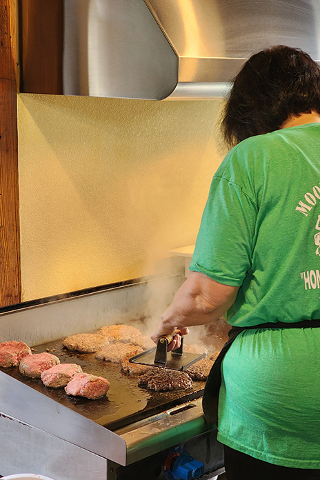
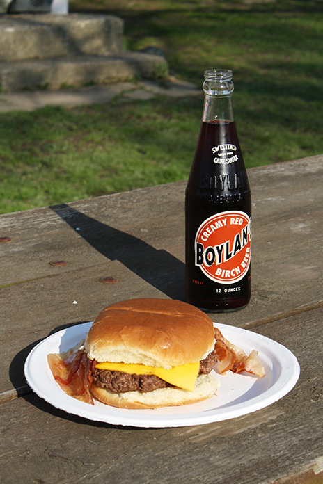
There’s no big secret to a Moonburger…just a large portion of fresh ground beef flattened on a grill. Yum!
Yes, more people visit southeastern Illinois for summer activities. The fairgrounds in DuQuoin host a race in the American Flat Track motorcycle racing series. The Illinois 300 NASCAR Cup race takes place in Madison. There are celebrations for German heritage in Waterloo and Hoyleton, Swiss heritage in Highland, and roots music and barbeque in Mt. Carmel. There are sailing events, a world trapshooting championship, art fairs, music festivals, county fairs, and much more.
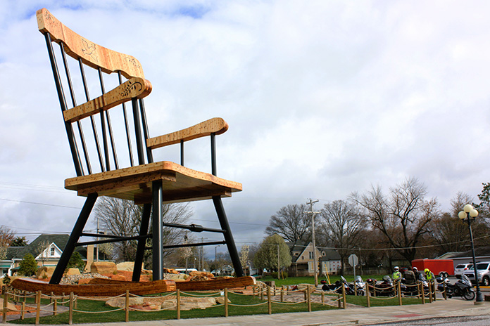
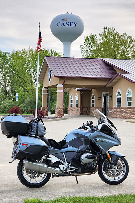
Oversized curiosities, including the world’s largest rocking chair, are on display throughout Casey, Illinois.
Since I’ve always ridden to Illinois in April, I haven’t experienced summertime there. But I’ve enjoyed visiting the town of Casey, some 14 miles from Moonshine and home of the world’s largest mailbox, pencil, pitchfork, wind chimes, rocking chair, golf tee, and other oversized curiosities. Since my last visit, someone added the world’s largest antlers. Every MLR has brought me to Casey, and getting there always involves varying degrees of challenge. Other riders who made it overcame their own challenges. As Terry would say, we “get it.”
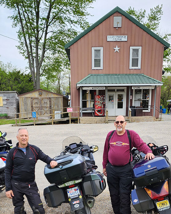
Above: Scott Williams (left) and Steve Efthyvoulou in 2010, at their first Moonshine Lunch Run. They’ve made eight trips together to Moonshine. Below: Scott and Steve did the 2023 run together. There’s less hair these days – and what remains is gray – but the smiles are still there.
Since the MLR is no longer an official event, there weren’t 1,000‑plus riders like before. This time there were a few dozen, with the largest contingent being members of the Motorcycle Tourer’s Forum. But as I’ve come to expect, the effort to get there – and to connect with other riders who did the same – was well-rewarded.
I ran into Mike Brown of Harrisburg, North Carolina, whom I’d seen at multiple MLRs. “If you have been there, you want to go back,” he said. “If you haven’t been there, you need to go!” Mike brought along a first‑timer, Bob Sweet of Concord, North Carolina. Unlike most riders who come on touring bikes, Bob made his first ride to Moonshine on a naked bike, his 2021 Triumph Street Triple 765 R.
“When we left Harrisburg at 4 a.m., it was dark and drizzly,” Bob told me. “I couldn’t tell Mike ‘I can’t do this.’ I got over the mental barrier, and here I am.” Bob gets it!
Casey, Illinois, located not far from Moonshine, is the adopted hometown for many long-distance motorcycle riders.
I met Darryl Halbert, who has been to every MLR since 2011, though somehow our paths never crossed. He used to live in Atlanta, Georgia, and his ride to Moonshine would include entertaining curves through the Appalachian Mountains. He’s retired now and living in Denver, Colorado, so he rode to Moonshine across the plains. “There’s a lot of Kansas between here and Colorado,” he chuckled.
I also met Greg Rice, a genuine legend in the long‑distance rider community, who told me about another “lunch run” he had made. As the Ft. Lauderdale, Florida, resident recalled, “I wanted to take a picture of my bike by the Panama Canal.” So Greg rode to Panama. He got the picture and had a burger for lunch. His round trip took 10 days.
Significantly, some MLR traditions carried on this year, like dinner at Richard’s Farm on Friday evening and Renee Handelman’s cinnamon buns on Saturday morning. I enjoyed my Moonburger with cheese and bacon at a picnic table beside the Moonshine Store with other riders, and it was good. Soon after, my group began our rides home to Texas, Michigan, New Jersey, Connecticut, and Massachusetts.
The Moonburger (single with cheese and bacon variant) pairs well with a Boylan’s birch beer.
Riding east together, Steve and I endured the wettest day in our combined Moonshine history. Over dinner in a warm, dry restaurant, we laughed about it. Adventure is just discomfort retold at leisure, and we’ve had our share of adventure on our runs to Moonshine. Bone-chilling cold. Scorching heat. Nasty storms. Roads that became rock-strewn goat paths despite maps promising otherwise.
Was this year’s Moonshine Lunch Run just like old times? Not exactly. But it was today’s version of good times, shared with other long-distance riders who get it. I expect Terry would be good with that.
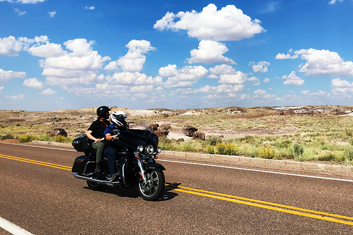
Fellow riders take in the otherworldly landscape of Arizona’s Petrified Forest National Park along the author’s Flagstaff to Albuquerque motorcycle ride.
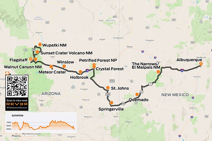
If you blindly follow your GPS, a Flagstaff to Albuquerque motorcycle ride is a 320‑mile drone on Interstate 40. That’s fine if Point A to Point B is your only plan. However, most motorcyclists are suckers for interesting byways and intriguing places, and I am no exception.
Embracing that character trait, I planned a convoluted ride that would add about 180 miles and several hours to this trip. I was not just adding saddle time; I was also adding several historically and culturally significant landmarks. Instead of simply slaloming through long‑haul trucks on the freeway, I would make a loop through three national monuments near Flagstaff: Wupatki, Sunset Crater Volcano, and Walnut Canyon. Continuing east, I’d visit Meteor Crater, Standin’ on the Corner Park, Petrified Forest National Park, and in New Mexico, El Malpais National Monument.
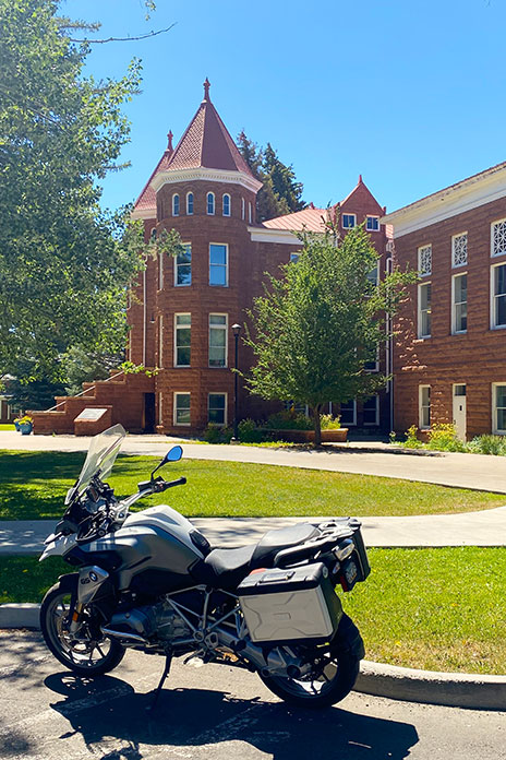
Before that roundabout route, I needed to spend some time in my all‑time favorite small city, Flagstaff. I lived some of my most memorable years in these mountains. I am a graduate of Northern Arizona University in Flagstaff, and any time I’m in the sky‑high city is a personal joy.
As I rolled through the campus for some serious reminiscing, many of the buildings brought back indelible memories. There is one location that is uniquely special. I spent my sophomore year in the school’s stately Old Main building when it was still a dormitory. Decades before I was a gleam in anyone’s eye, my parents took a photo on its iconic steps. The historic red Moenkopi sandstone building was constructed in the late 1800s and is the centerpiece of both the beautiful campus and my love for Flagstaff.
The author stops to reminisce at Northern Arizona University’s Old Main building in Flagstaff.
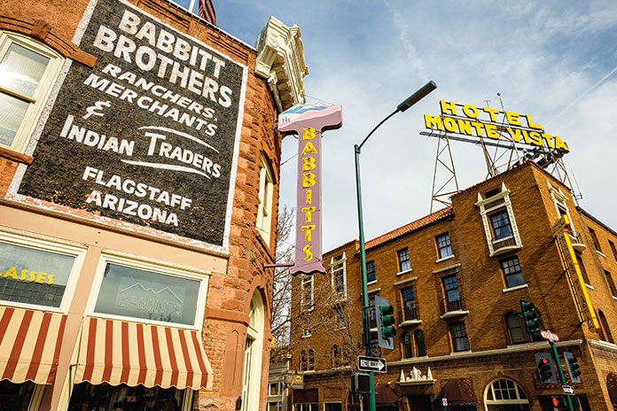
After leaving the campus, I rode through Flagstaff’s charming downtown area. Iconic hotels in the area like the Hotel Monte Vista and the Weatherford cast a historic shade over the lively, rejuvenated entertainment and shopping district.
Downtown Flagstaff, Arizona.
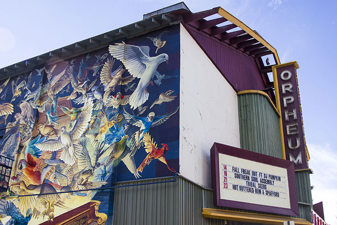
There is no shortage of things to do downtown, including the Orpheum Theater, many dining options, and unique specialty shops. The area is much more polished and refined than when I was in college.
Flagstaff’s revitalized downtown area, which sits at nearly 7,000 feet on the Colorado Plateau, is a hotbed of activity in both the cool summer months and when blanketed in snow.
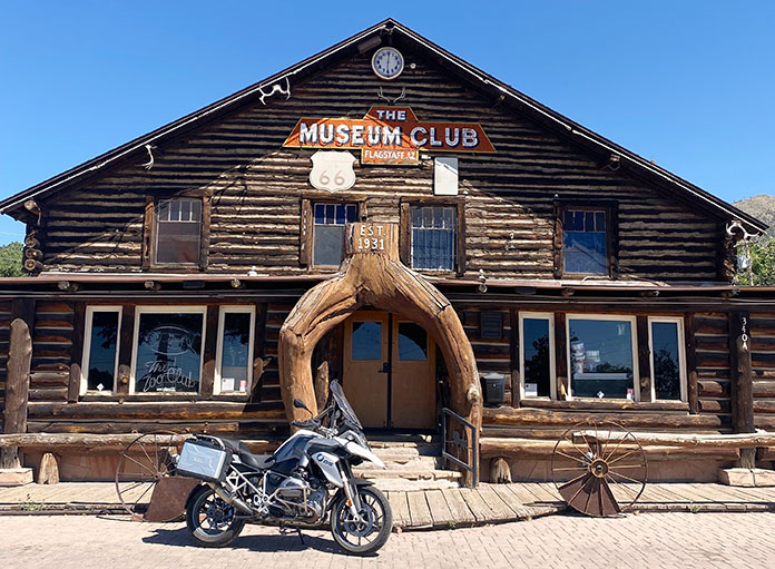
As an undergraduate, I spent a fair amount of time “studying” in various Flagstaff watering holes, like the venerable Museum Club. This time around, as I dropped the kickstand in front of the log‑built establishment dating back to 1931, visions of live bands and lukewarm beer flooded my memories. Some of Flagstaff’s history was lost on me while matriculating, but the slightly more mature “me” appreciates the vintage, mountain‑chic nature of the city that lies on historic Route 66.
The historic Museum Club has been a fixture in the mountain city since the Great Depression era, and it was one of the author’s favorite haunts during his college days.
After leaving Flagstaff, I headed north on U.S. Route 89 toward the scenic loop through the first two national monuments slated for my ride. This first little spur of my wandering route to Albuquerque was more of a flyby, as I have visited both Wupatki and Sunset Crater Volcano in the past.
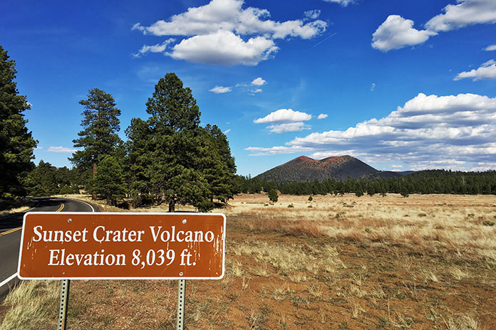
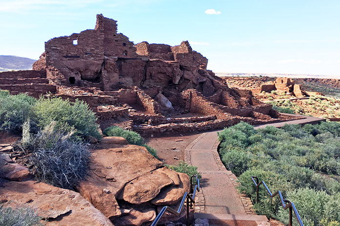
Near the northernmost point of what is fittingly called the Sunset Crater‑Wupatki Loop Road is a significant archeological site. In the early 1100s, Pueblo communities built Wupatki, a bustling center of trade and culture. The site is well worth a walkabout. After looping farther through the otherworldly landscape of this part of northern Arizona, I came to Sunset Crater Volcano. You can see virtually the entirety of the park from the saddle along the loop road. Peering directly into the mouth of the cinder cone is no longer permitted due to foot traffic erosion; however, a long view of the nationally protected volcanic field is still a wonder to experience.
Sunset Crater Volcano, formed during an eruption in 1085, rises more than 1,000 feet above the surrounding landscape and is visible from most of the scenic loop road.
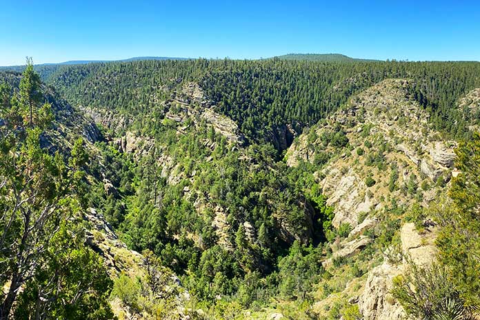
After completing the loop road, I headed east on I‑40 for a skinny minute to the access road for a national monument I had not visited previously. Walnut Canyon is just a short jog off the interstate through pines, oaks, and junipers. The endgame is a visually stunning canyon environment rich in rugged natural beauty and early human history. I did not walk the park’s Island Trail, a strenuous one‑hour hike past the early cliff dwellings; however, I took in the big‑picture experience of the park’s rim trail, which offers great views of the dwellings and the rugged topography.
Wupatki National Monument sits as a visually stunning reminder of past civilizations.
At this point in my Flagstaff to Albuquerque motorcycle ride, I had been in the saddle or exploring for well over an hour, and I was only 8 miles outside of my original launching point. I did say I was not taking the most direct route to Albuquerque! My eastward trek resumed on I‑40 and was exactly what freeway travel is designed to be: fast, efficient, and boring. My speedometer needle was pinned resolutely at 75 mph as I rolled through the tall pines of northern Arizona, which melted into junipers and then grasslands as I made my way toward the next attraction.
Walnut Canyon, a short hop off Interstate 40, is easily accessible even in motorcycle boots.
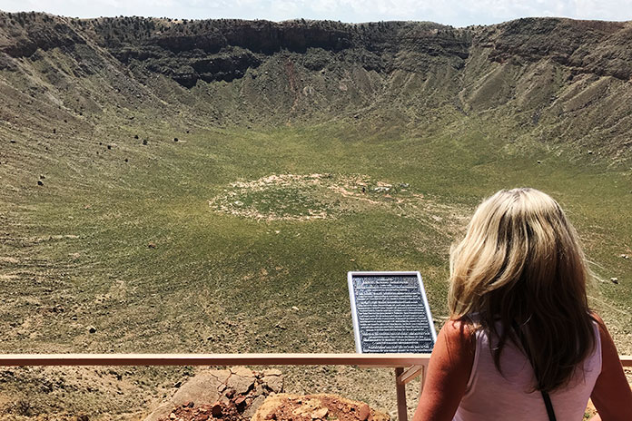
About 40 miles out of Flagstaff, I came to the exit ramp for Meteor Crater. There are numerous “teaser” signs along the access route that are intended to build anticipation for the natural wonder at the road’s terminus. As I approached, I saw the ultimate teaser: an enormous raised, round “lip” that is evidence of the cosmic collision that occurred thousands of years ago.
I rolled into the parking lot and secured my pass to see the crater. On my way to the viewing areas, I enjoyed a series of museums and displays that cover the history of space travel, hypothetical (corny?) representations of aliens, and the scientific nature of the meteor that found its way to earth some 50,000 years prior to my visit.
The author’s wife takes in the view at Meteor Crater, which is located between Flagstaff and Winslow, Arizona. The site offers several fascinating observational perspectives.
As I finally made my way outside the facility to the viewpoints along the rim of the crater, the massive bowl did not disappoint. One cannot help but stand in awe of the impact that created the earthen wound. There are several vantage points from which to view the crater, as well as preset telescopes for a closer look at its interesting features. Well worth the visit.
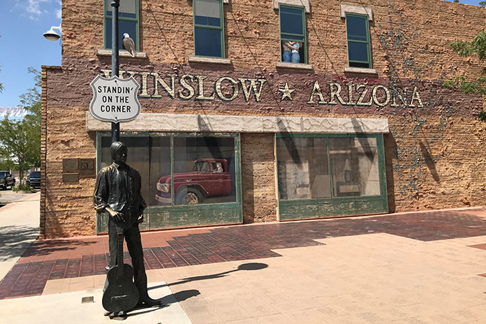
With the cosmic pockmark fading in the rear views, I was back on the interstate for a quick jaunt. Most of this ride was a survey in ancient places, but there was a little musical interlude singing its siren song in downtown Winslow. I pulled up to the intersection of Route 66 and North Kinsley Avenue, now designated as Standin’ on the Corner Park, where a flatbed Ford was conspicuously parked.
Sure, it’s kitschy, but for anyone who has crooned along with the 1972 Eagles song “Take It Easy,” it’s a must stop. I took the requisite photo with a bronze Glenn Frey and searched in vain for the girl in that flatbed Ford. Winslow is also home to the historic La Posada Hotel, the Old Trails Museum, and Homolovi State Park.
No Route 66 ride would be complete without stopping at the “corner” in Winslow, Arizona.
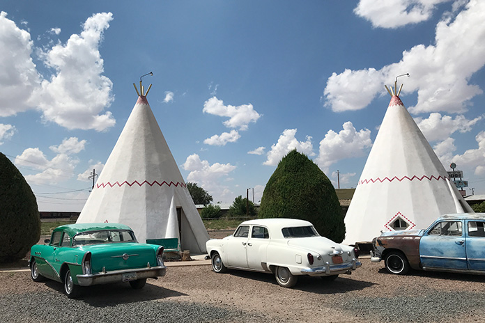
Again heading east, the next town of note into which I rolled was another Route 66 remnant. Just off Holbrook’s main drag rests an iconic mid‑century attraction. Over a dozen large, conical teepees make up the historic Wigwam Motel. Those structures and the classic cars staged around the property beg for a visit and photos.
The Wigwam Motel, a Route 66 fixture in Holbrook, Arizona, is worth a stop for a dose of 1950s Americana.
Just 30 miles east of Holbrook is the exit for Petrified Forest National Park. I rode due south on what would be an extended departure from any interstate highway. After paying my entry fee, I rolled into a lunar‑esque landscape rich in pastel hues and forever views. The road through the heart of the park is 26 miles of intrigue.
I stopped at Newspaper Rock, which features hundreds of ancient petroglyphs of animals, weapons, and humans. The etched figurines tell a fascinating story, including how the exaggerated endowment on the male stick figures speaks to the fact that men never change.
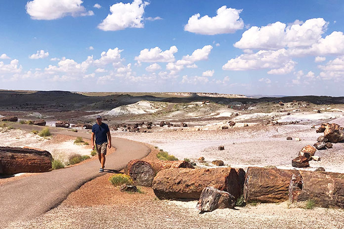
The author pulled off his riding gear for a walk through the Petrified Forest, which preserves fossilized logs from trees that lived 225 million years ago.
At my next stop, the park’s Crystal Forest, I pulled off my gear for a walk among the massive petrified logs that lay strewn throughout the undulations of the walking path. The path is a sojourn into a prehistoric wonderland. Logs lay as massive, independent rounds as well as segmented pieces where they fell millions of years ago.
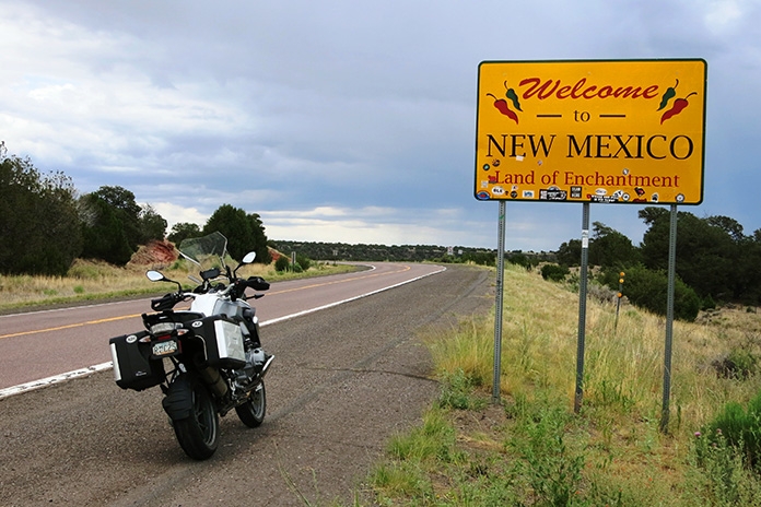
Entry into New Mexico brings with it a unique Southwestern feel.
Geared up again, I exited the park to the south and continued on the longest side leg of this elongated ride to Albuquerque. I rode through the remote eastern Arizona towns of St. Johns and Springerville before heading due east on U.S. Route 60 into New Mexico. The grasslands and high chaparral landscape are wide‑open and beautiful, making for a fun Southwestern riding experience.
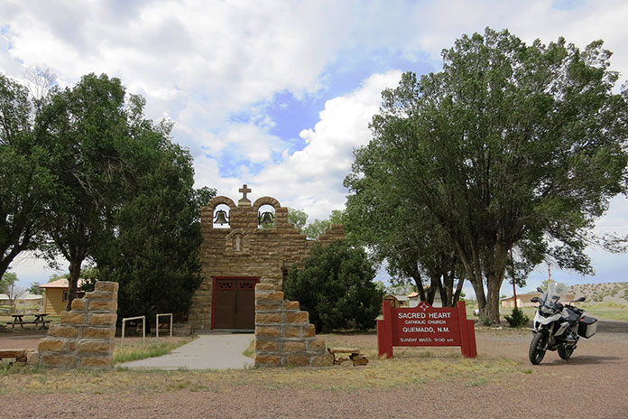
At the small New Mexican town of Quemado, I stopped for a quick look at the tiny Catholic mission on the outskirts of the hamlet, one of many such historic missions in New Mexico, before heading north on State Route 36. The high‑desert riding continued on State Route 117 until I came to the last of my planned stops.
Historic missions and other religious landmarks dot New Mexico’s beautiful landscape.
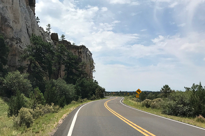
The Narrows is a striking rock rim feature within the El Malpais National Monument. The road follows that sheer rim for a nice stretch before the ledge eases and separates from the tarmac. The next notable feature is a picturesque natural rock bridge to the north of The Narrows. A short walk reveals the grandeur of the La Ventana Natural Arch. After a visit, my route rejoined the freeway for the final stretch to Albuquerque.
The Narrows in El Malpais National Monument is a hidden treasure in western New Mexico.
Nope, this was certainly not the quickest Flagstaff to Albuquerque motorcycle ride, but it was infinitely more memorable.