While the majority of visitors to Joshua Tree National Park stick to the pavement, there are several dirt roads that finger into the beautiful desert landscape, perfect for this Joshua Tree National Park motorcycle ride. (Photos by the author and Cheryl Kessel)
“It’s the Joshua tree’s struggle that gives it its beauty,” writes Jeannette Walls in her 2005 memoir The Glass Castle. She further contends that such struggle leads to growth and resilience. We motorcyclists know all about struggle, especially in the depths of winter. We struggle to find ways to assuage our overwhelming desire to ride as snow blankets roads and freezing winds cut like knives. For us, the Joshua tree can also represent escape and relief.
My wife and I sat in the morning sun in the courtyard of the beautiful Dive Palm Springs, a downtown boutique hotel in the vibrant California desert city (see sidebar below). As we ate croissants and fresh fruit, we discussed our January therapy session: riding our BMW G 650 XCountry through Joshua Tree National Park.
The ride out of Palm Springs was easy. The city has embraced and preserved its mid-century heritage and charm. Buildings, landscaping, and signage harken back to the city’s heyday as a mecca for L.A.’s rich and famous. We rode alongside expansive golf courses and tennis courts. Once out of the city, we continued east on Interstate 10 through the muted hues of the Mojave Desert.
Joshua Tree National Park has three entrances, and our route took us to the southernmost entrance near I-10. There was no wait at this lesser-used access, and our National Parks Annual Pass granted us entry.
Our ride north into the park started as a nicely paved roll through the sparse desert landscape on Pinto Basin Road. Mountains rose on the horizon, but no Joshua trees. A full palate of cacti, including chollas and ocotillos, defined our early impressions of the national park. Long sweeping corners and smooth straight stretches marked the climb in elevation. The road became more curvaceous, and the park’s namesake trees started to appear sporadically, foreshadowing what was to come.
The author’s wife, Cheryl, stands in front of the park’s entry signage.
Pinto Basin Road terminates at Park Boulevard. A right turn would lead us north to Twentynine Palms, the city immortalized in a great Robert Plant song of the same name. Instead, we turned left into the heart of the park and the center of the Joshua tree universe.
The roads through Joshua Tree offer up starkly beautiful visual backdrops. The rock vistas, desert sand, and unique trees combine for a remarkable riding experience.
Almost immediately, the stands of Joshua trees became denser, the trees larger. Joshua trees are fantastical, whimsical, and majestic all at once. It is as if each one has a personality of its own. Some are simple and understated, but many are over-the-top in their stylized poses. Arms emanate in every direction and at rakish angles that seem almost comical, like attention-seeking adolescents with limbs akimbo and wild haircuts.
Our first pedestrian foray was at the fantastic erosion-sculpted Skull Rock. My diminutive riding companion could easily fit within one of the cranial cavities in the impressive monolith, one of many sculpture-esque outcroppings of granite in this portion of the park.
Cheryl stands in front of one of the park’s most recognizable features, Skull Rock. The rock morphs in appearance with the changing shadows throughout the day.
After a few more miles on our northwestern route through the park, we sampled one of the established dirt roads that wind through Joshua trees. Vehicles must stay on approved roads, and there are several dirt roads that offer off-pavement possibilities for dirt-worthy mounts. Our midsized BMW proved perfect for a little sandy exploration.
Back on tarmac, we motored past climbers scaling the vertical walls of beautiful rock formations. We also cut through the part of the park that features the most spectacular Joshua trees, which cast long shadows in the late afternoon light, adding an otherworldly quality to the ride.
After leaving the park, we rolled back to Palm Springs on Twentynine Palms Highway (State Route 62). We motored west and then south past Desert Hot Springs and beside a different forest – one of towering wind turbines. Back in Palm Springs, we showered off the day’s ride and headed downtown to enjoy the Palm Springs Village Fest, an event hosted every Thursday that features art, food, music, and lots of smiling attendees.
With our therapy session complete, we felt much better. This ride would be oppressively hot during the summer, but it’s the perfect escape in fall, winter, and spring months.
Dive Palm Springs is a quaint and beautiful 11-room boutique hotel on the fringe of downtown Palm Springs. The petite, Euro-inspired property is meticulously maintained, with a restored historic pool as its centerpiece. A welcoming glass of rosé greets new guests, and an individually prepared organic breakfast is delivered to your room or beside the pool each morning. This hidden gem is the perfect place to recline in luxury after a long ride.
Joshua Tree National Park Motorcycle Ride Resources
With 50 years of motorcycling and 30 years of teaching English under his belt, Tim Kessel has melded those two passions into a gig as a motojournalist. Maybe that’s why there is always a permanent, satisfied smile under his full-face helmet.
Greg’s BMW taking a dirt nap along the Oregon Backcountry Discovery Route. Photos by Greg Drevenstedt.
This story is about a ride that took place in 2013 on the original Oregon Backcountry Discovery Route, which was developed by the Oregon Off-Highway Vehicle Association. The nonprofit Backcountry Discovery Routes organization developed a new ORBDR that was released in 2023. For more information, visit the Backcountry Discovery Routes website. –Ed.
Route 5 of the original ORBDR includes hundreds of miles of gravel roads much like this one, plus a decent helping of dirt, sand, rock gardens, and river crossings.
When your bike topples over in the middle of nowhere, when your bike and its week’s worth of gear weigh more than 600 lb, when you’re hot and sweaty and tired, it’s good to have friends along to lend a hand.
At the California-Oregon border before venturing off-pavement on the ORBDR.
We were three days and nearly 300 miles into the 750-mile, California-to-Washington Route 5 of the Oregon Backcountry Discovery Routes (ORBDR), a network of off-road routes crisscrossing the state’s vast national forests. While struggling my way up a technical jeep road full of embedded rocks, I high-centered the BMW’s skid plate, dabbed my left foot into a hole, lost my balance, and toppled over in a big, dusty heap.
Lead rider Paul was off in the distance, so sweep rider Marten navigated around me, parked his bike on a level spot, and came back to help. Other than some badge-of-honor scratches on the bike, the only damage was to my pride, and I was soon making forward progress again.
Just a few miles into the ORBDR, we took a spur road to the summit of 8,000-foot Crane Mountain, where we enjoyed 360-degree views of California and Oregon.
Backcountry Discovery Routes is a nonprofit organization that establishes and preserves off-highway routes for dual-sport and adventure motorcycles. BDR has mapped and documented north-south routes in most states west of the Rockies as well as mid-Atlantic and Northeast routes and shorter BDR-X routes. Inspiration for these routes came from the ORBDR, which, according to BDR’s website, “was created a few decades ago by Bob and Cheryl Greenstreet as a concept to promote managed travel in the backcountry” and is maintained by the Oregon Off-Highway Vehicle Association.
The view from Fremont Point on Oregon’s Winter Rim.
Paul, Marten, and I wanted to ride the granddaddy of the Backcountry Discovery Routes, so I bought paper maps for Route 5 from OOHVA and Paul spent two weeks creating GPS tracks for us. (GPS tracks are now available upon request when maps are purchased from OOHVA.) Since most of the ORBDR is at 4,000-8,000 feet of elevation, we planned our trip for August to avoid snowpack.
A long-time adventure-riding and homebrewing buddy of mine, Paul Beck, is a computer guy. Since he created our tracks and led our group (his GPS was the only one that worked reliably), we dubbed him the Navigator. Marten Walkker, another riding buddy, is a master carpenter. He made his own tailbag, auxiliary gas tank, toolbox, and highway pegs for this trip, so we called him the Fabricator. And since I kept a journal, shot photos, and sent daily postcards to my wife, I became the Chronicler.
The Three Amigos at Fremont Point, 3,000 feet above seasonally dry Summer Lake.
Similar in pace and temperament and always ready for a quick laugh, we were compatible travelers, like the Three Amigos. We were all of German descent and riding BMWs – Paul on an R 1200 GS, Marten on a G 650 Xchallenge, and me on an F 800 GS Adventure – so Drei Freunde is more accurate, but it doesn’t exactly roll off the tongue.
We had to cross the high desert through Christmas Valley to get from the mountains of Fremont National Forest to the mountains of Malheur National Forest.
Departing from Ventura on California’s southern coast, our first 750 miles were on pavement as we made our way up to the northeastern corner of the state. A half-mile before the Oregon border on the afternoon of our second day, we turned from U.S. Route 395 onto the unpaved County Road 2 and entered Modoc National Forest as we climbed into the Warner Mountains. We had to shift our brains from the grip and monotony of wide-open pavement to the delicate balance of riding top-heavy adventure bikes on loose, uneven dirt and gravel. The road leveled out within a few miles, and we turned north, passing through the green meadows of the (not so) Dismal Swamp and crossing into Oregon.
River crossings are nerve-racking with an audience of forest service workers, but Marten made it through like a pro.
After riding a challenging spur road up to the top of 8,000-foot Crane Mountain for panoramic views and navigating through a herd of cows, we stopped at Willow Creek Campground, which was deserted. We crossed a cattle guard to get into the campground, and even though it was surrounded by a fence, we still had to pick our way through a minefield of cow patties to set up our tents. After bathing and rinsing out our sweaty clothes in the creek (but not drinking the water), we fortified ourselves with backpacker meals and relaxed around the campfire, swapping stories and sipping whiskey.
Cooling off in Delintment Lake in Malheur National Forest.
The OOHVA’s detailed, full-color ORBDR map booklets offer the following words of advice: “Your journey will be one of few contacts with others. One needs to plan for being self-sufficient. Travel with others is highly recommended. If one’s means of transport fails, it can be a really, really long hike, and it could be many days before someone comes along.”
The early bird gets to enjoy the sunrise.
Over the course of five days on the ORBDR, we saw only a handful of people – a few ranchers, a couple of 4×4 trucks, and the occasional hunter. We traveled as a group, each of us brought our own food, water, and gear, and we carried a SPOT satellite tracker/communicator. Gas was available every 100 miles or so, often in small towns or at convenience stores near the route, and we filled up our tanks and hydration backpacks at every opportunity.
Lunch stops at local cafes provided welcome relief from the hot, dusty trail.
“Much energy has been spent to provide you with maps that provide the information needed to successfully navigate without on-ground signs,” says the OOHVA. We saw only a few faded, old ORBDR signs over the entire 750-mile route.
“The development of route was financed by the Oregon ATV Allocation Funds,” said Leonard Kerns, president of the OOHVA, in a blog on Touratech-USA’s website. “On-the-ground signs were placed and the route was dedicated in the summer of 2000. Unfortunately, it did not take long for people opposed to the route to bring legal action. Support from the Forest Service and Bureau of Land Management was lost and all remaining funds were used to remove the signs. At that point, OOHVA stepped in and created the maps using GPS to navigate.”
Breakfast of champions.
The ORBDR is on public land, so anyone can travel the route using a street-legal vehicle, but much of it passes through areas used for grazing and logging. We crossed dozens of cattle guards and stopped often to open and close barbed-wire gates. Forest land in central and eastern Oregon is all but empty, yet it’s crisscrossed with so many access roads that without GPS tracks and paper maps, getting lost is all but assured.
Even with GPS tracks, sometimes we hit dead ends and had to find a way back to the correct trail.
One of several massive fallen trees we had to navigate around since going over wasn’t an option!
The OOHVA’s maps were created in 2002, and in the years since, some roads have been closed and new ones have been cut. Even following the purple line on Paul’s GPS, we still made wrong turns or hit dead-ends and had to figure out how to re-route ourselves. We also encountered the unexpected, such as fallen trees and man-made barricades. Therein lies the adventure. Riding a backcountry route is not like following the Yellow Brick Road; it requires not only preparation and riding skills but also teamwork, patience, and adaptability.
Being far from anywhere, we had campgrounds largely to ourselves and were fortunate to have either a stream or lake nearby.
We quickly established a routine: waking early to heat up water for coffee and oatmeal using portable stoves, breaking camp, riding for several hours, stopping for lunch and gas, riding for several more hours, then stopping early to set up camp and relax. Paul was always in the lead, which meant his gear stayed clean and we had someone to blame for wrong turns. I followed Paul and Marten followed me, and even with space between us the dust filled our noses and covered our gear, making zippers and buckles hard to open and close. We planned to camp every night, but it didn’t work out that way, to our surprise and benefit.
Lead rider Paul stayed clean; sweep rider Marten stayed dirty.
During our five days on the ORBDR, we experienced a steady stream of good luck. We enjoyed mostly warm, dry weather and had no flat tires, breakdowns, or injuries. Rather than eating jerky and energy bars for lunch, we usually found a cafe in a small town where we’d refresh ourselves with air conditioning, limitless iced tea, and other luxuries, and there was always a gas station nearby to fill up and resupply.
We smelled smoke but had no idea the 1,000-acre Vinegar Fire was burning in the area until we popped out of the trees and came upon this U.S. Forest Service fire security truck. Our route was supposed to go down that gravel road in the distance, but we were re-routed onto pavement to the town of Ukiah.
During the three nights we camped, there was either a cool stream or a lake we could swim in to wash off the dust and relax our creaky joints. On our second day on the ORBDR, after a challenging, tiring section with lots of sand and rocks, we ended up in the town of Christmas Valley, where the Lakeview Terrace motel/restaurant spoiled us with cheeseburgers, fries, cold beers, hot showers, and soft beds.
Antlers Inn in Ukiah has a room-size meat cooler to store your game.
Even when we had to leave the ORBDR to route around the 1,000-acre Vinegar Fire, we got to ride 50 miles on the freshly paved Blue Mountain Scenic Byway and ended up in Ukiah on a damp, foggy night. Instead of pitching tents and eating freeze-dried meals in the rain, we stayed warm and dry at the Antlers Inn and savored burgers and beers at the Thicket Cafe & Bar. We enjoy roughing it, but we’re not too proud to take advantage of good fortune when it lands in our laps.
Chris ran the Antlers Inn and served us at the Thicket Cafe & Bar, where she recommended an Oregon-distilled whiskey.
Our five days and three nights on the ORBDR provided us with as much adventure as we could hope for. We rode more than 700 miles on dirt and gravel roads through the backcountry of Oregon, through dense forests, across high-desert plains, along mountain ridges, away from cities and people and normal obligations. We rode through rock gardens and sand washes, forded rivers, and navigated over or around countless obstacles, challenging ourselves and having fun. We had campgrounds to ourselves, where we enjoyed star-filled nights and soul-warming campfires, and we stumbled upon cozy motels and restaurants, where we enjoyed creature comforts.
We were treated to some of the best scenery of the ORBDR, such as wide-ranging views from Kendall Skyline Road in Umatilla National Forest, on the final day.
Paul, Marten, and I – the Navigator, Fabricator, and Chronicler – bonded over the experience. When we reached Walla Walla, Washington, the northern terminus of the ORBDR, having ridden 1,500 miles together, we high-fived and celebrated our shared accomplishment. The next day we headed off in different directions, Paul to Seattle, Marten to Calgary, and me home to Ventura, completing an Iron Butt SaddleSore 1000 in the process, but that’s another story.
After five days and 750 long-and-dusty, not-so-straight south-to-north miles, we completed Route 5 of the ORBDR and arrived in Walla Walla, Washington.
Every trip starts with a send-off and the first mile. This banner about supporting the Parkinson’s Foundation made the entire journey with me.
In 2021, Steven Goode completed the Great American Deli Schlep, a 75‑day, 15,000‑mile motorcycle ride during which he visited the best Jewish deli in nearly every state and raised funds for MAZON, a Jewish nonprofit that fights hunger in America. You can read Goode’s feature about that ride here. –Ed.
I haven’t been everywhere, but it’s on my list.” This is a quote by Susan Sontag and words I ride by.
Beartooth Pass Summit (see next photo) was the crescendo of a magnificent ride on Beartooth Highway from Wyoming into Red Lodge, Montana. Hairpin curves, few guardrails, and sweeping views make it one of the best scenic byways in America. (Photos by the author)
After completing four major motorcycle trips around our wonderful country, each ranging from 11,000 to 17,000 miles, I told my wife I was done with long‑distance rides. Sort of the same way I’ve told her, many times over, that this was going to be my last motorcycle purchase. Of course, she didn’t believe me.
So when a riding buddy said we should plan a big trip, I was all in. All I needed was a cause and a theme for the ride.
For a cause, I chose the Parkinson’s Foundation. In 2001, my mother passed away from Parkinson’s disease. A motorcycle trip supporting this cause would be a great way to not only honor her memory but raise money to support finding a cure and providing resources for those afflicted with this terrible disease.
Although my mother most likely would not have approved of my 60‑day, 16,000‑mile motorcycle trip – she was still a mother after all – she would have been extremely proud of my commitment to this cause. She had a wild side, but she didn’t show it often for fear of encouraging her sons to follow in her path, which we did anyway.
My late mother was the inspiration for this tour. This photo shows us in our backyard in 1979.
When I told the Parkinson’s Foundation about my plan, they were immediately supportive and offered to help create public awareness for the trip. An important part of the publicity was social media. I’m in my late 60s, and I didn’t do Facebook, Instagram, TikTok, etc., so their team handled that for me. They also created logos and designed T‑shirts, banners, and a web page for my blog. Klim supported the ride by providing me with a Latitude Gore‑Tex suit, and Nelson‑Rigg provided some waterproof luggage.
Scan the QR code or click here to make a donation to the Parkinson’s Foundation.
We named the ride The Great American Scenic Byways Tour supporting Parkinson’s Foundation. After reviewing the route and the time necessary to complete the ride, my friend said the trip would require too much time away from work, so he bowed out. Since I had already committed to the Foundation and this was a personal ride on behalf of my mother, I decided to go alone.
My friend Bruce Benton joined me for a wonderful ride on the Cherohala Skyway in Tennessee and North Carolina.
For those of you who are curious how someone plans a 16,000‑mile trip, here are a few guidelines. First, get a map of the United States and put markers next to the places you plan to travel to. Second, using the rough route map, create a spreadsheet with columns for the city in which you begin your day’s ride; the destination city for that day; miles you plan to ride each day; and notes about the route, landmarks, and things to see. Good planning is key for a successful ride, and being organized reduces stress.
In Delaware I rode the Bayshore Scenic Byway. My Honda Gold Wing was a faithful companion on my deli schlep and scenic byways tours.
A key element to any trip of this magnitude is planning for unforeseen events. My mantra is “It’s all about Plan B.” On a two‑month trip, there will be at least one unexpected twist pop up. Mine came three days in when my dermatologist called to tell me I had a melanoma on my back and he wanted to surgically remove it as soon as possible. Plan B: I turned the bike around, made a beeline to Chicago, had the surgery, and was back on the road 17 days later.
Cape Hatteras Light Station on the Outer Banks Scenic Byway in North Carolina.
The beauty of this ride’s theme was that each scenic byway has its own personality. Like a thumbprint, every byway is unique. Almost everyone I met during the trip asked me, “What is the best scenic byway?” Just like when asked what the best motorcycle is, I answered, “The one I’m riding.” There are good reasons why National Geographic picked each of these byways to include in its guide. Each one gives the rider a special glimpse into the beauty of the region.
This is the Blue Ridge Parkway near Blowing Rock, North Carolina, where the weather seems to change every minute. The quintessential scenic byway is one of America’s treasures.
For example, the Red River Gorge Scenic Byway in Kentucky took me into forested backcountry, and I was able to get lost in my thoughts in the deep woods. One of the interesting features of this scenic byway is the Nada Tunnel, which is 900 feet long but only 12 feet wide and 13 feet high. There’s a single lane through the mountain, with no lights or painted lines. While pondering how to go through it, I asked some local Harley riders for advice. They said, “Look for a headlight at the end of the tunnel. If you see one, don’t go.” I felt like I was in a Road Runner cartoon.
The Nada Tunnel is located near the Red River Gorge Scenic Byway in Kentucky.
In Newport, Rhode Island, the scenic 10‑mile Ocean Drive provided a glimpse of how the other half lived during the Gilded Age in the late 1800s. The Vanderbilt, Astors, and Morgans all had their summer homes along this rocky coast.
Mansions along Rhode Island’s Ocean Drive.
Spanning two states, the Talimena National Scenic Byway follows Arkansas Highway 88 and Oklahoma State Highway 1. On the morning I planned to ride it, the forecast said it would be 105 degrees in Dallas, Texas, my next destination. I left at 5 a.m. to arrive in Dallas in time to beat the heat. This early start gave me an opportunity to watch the sunrise over the byway.
Sunrise over the Talimena National Scenic Byway, which goes through Arkansas and Oklahoma.
After five days on the road, I could no longer remember where I was the day before, what I had for dinner the night before, or which hotel I stayed in. That’s one of the great things about a two‑month motorcycle trip – getting lost in the journey. Writing a blog forced me to recreate the trip daily so it didn’t become one huge blur, and it also allowed friends, family, and supporters to follow my progress.
An old steam train in Essex on the Connecticut Valley Scenic Byway.
Another benefit of a trip of this scale is all the things I learned along the way. Like a school on wheels, I learned about our United States up close and personal, gaining a new appreciation for each region’s distinct personality and history. After the trip, I had a better understanding of our collective history. Whether it was exploring what life was like on plantations, following the Trail of Tears, or riding the path of Lewis and Clark, I was able to take a long look at our country and how we grew up as a nation, both the good and the bad.
Slave quarters at the Oak Alley Plantation in Vacherie, Louisiana. This tour provided an education on America’s past, present, and future.
Every long motorcycle trip has unexpected moments, and one left me speechless and cleaning the mess off my bike for days. Leaving Elko, Nevada, to ride to Idaho, I took State Route 225, a two‑lane road with virtually no traffic. As I was riding north, I noticed something that looked like pinecones on the pavement up ahead. Once I got closer, the “pinecones” began to scurry. As I continued to ride north, they completely covered the road. Then I noticed that the road’s tire tracks were turning red, not asphalt gray. It was an infestation of Mormon crickets, which are about 2 inches long and don’t fly, and I was riding through an invasion of Biblical proportions that went on for 50‑plus miles!
Taking a pause to enjoy a view of the Sawtooth Mountains after riding the Ponderosa Pines Scenic Byway in Idaho.
My original plan was to ride through California’s Death Valley National Park. Just before I left, I received a call from my son. “Dad, did you hear that a 65‑year‑old guy just died in Death Valley? He had two flat tires on his car, and nobody came to his rescue. Are you sure you want to go into Death Valley by yourself, on your motorcycle, with temperatures reaching 115 degrees?” Plan B: Due to the intense heat and time constraints after my unexpected surgery, I opted to bypass California, Oregon, and Washington.
The Wetlands and Wildlife Scenic Byway in Kansas.
My favorite scenic byway changed from day to day. When I was on the East Coast, I loved the Rangeley Lakes National Scenic Byway in Maine. Riding the 17.6‑mile Chesapeake Bay Bridge‑Tunnel (U.S. Route 13) in Virginia, which includes a tunnel under the water, from Norfolk to Fisherman Island National Wildlife Refuge, was spectacular.
Somewhere in Maine, on my way to Rangeley Lakes Scenic Byway.
Out West, it was U.S. Route 191 (Coronado Trail) in Arizona and State Route 12 in Utah. Beartooth Highway in Wyoming and Montana is a must‑ride. It is hard to choose only one scenic byway because each is special, and every one of them gave me new perspectives on the areas I was traveling through.
U.S. Route 191 in Arizona between Alpine and Morenci is known as the Coronado Trail Scenic Byway – one of my all-time favorites.
People also asked, “How do you pack for such a big trip?” My only advice is to take less than you think you need but all that’s necessary for unforeseen conditions (rain, cold, heat, etc.). You must think through all the variables and prepare a Plan B. If traveling solo, use a satellite tracking device so family and friends know how to find you.
Riding through Bryce Canyon National Park, which is located just off Scenic Byway 12 in Utah.
Long motorcycle trips are not for everyone, but I love not knowing what is on the other side of the hill and feeling the thrill and power of the bike beneath me, experiences that keep me going day after day. I highly recommend checking out National Geographic’s Guide to Scenic Highways and Byways, picking a region, and planning your own adventure. I guarantee you won’t be disappointed. Take the time to enjoy the sights, sensations, and sinuous curves on America’s rich bounty of scenic byways.
On the way down from the 14,115-foot summit of Pikes Peak in Colorado.
During his Great American Scenic Byways tour, Steven Goode raised nearly $22,000 for the Parkinson’s Foundation. To make a donation, use the QR code aboveor click here. To read Goode’s blog, visit this page on Facebook. Below you’ll find a complete list of the scenic byways Goode rode on this tour.
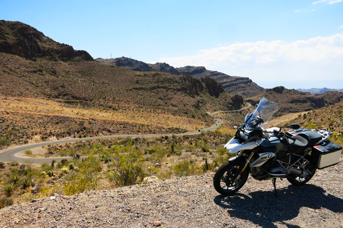
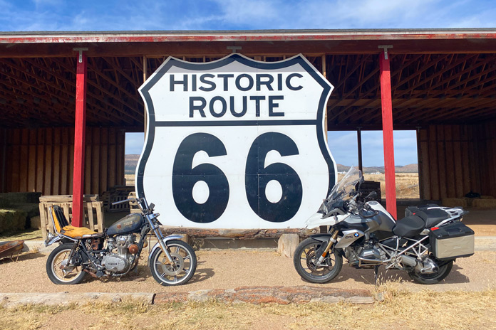
Riders enjoy the winding asphalt on this Route 66 motorcycle ride outside of Oatman.
Route 66, or the Mother Road, is indelibly stitched into the fabric of the American psyche. The iconic road once traced its way for 2,448 miles from Chicago, Illinois, to Santa Monica, California. But it was more than just a long stretch of tarmac. Route 66 became a cultural phenomenon that inspired and piqued the American obsession with travel and adventure. Songs were written about it, quirky and kitschy roadside attractions sprouted beside it, and Americans longed to traverse it. The Mother Road was a main artery crossing the torso of the U.S. through which dreams and possibilities pulsed warm and red.
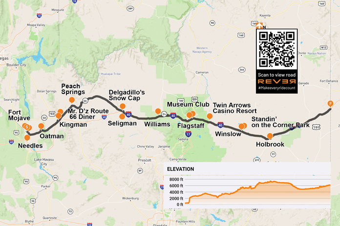
Yearning to rediscover the road, the towns, and the magic of Route 66’s path through Arizona, I packed up my BMW R 1200 GS and set out. Fittingly, my trek began Nov. 11, the date on which the Mother Road was designated a federal highway in 1926. Arizona claims the longest rideable portion of the original Route 66, and it has a significant number of attractions and bustling historic towns.
Riding from west to east, I began my Mother Road adventure on the Fort Mojave Indian Reservation where the Colorado River separates Arizona from Nevada. After a short climb toward the mountains on Boundary Cone Road, I came to an intersection indicating that I was transitioning onto the historic U.S. Route 66. The road became curvier and more interesting, and the jagged rock formations of Arizona’s Black Mountains became more immediate as the road coiled through the rugged terrain.
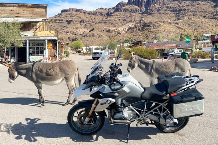
Friendly burros in Oatman weren’t impressed with my BMW beast of burden.
Within minutes, I entered the historic mining town of Oatman. In 1915, two miners struck a $10 million gold find. Within a year, the small mining camp grew to a population of 3,500. Recent census figures indicate there are now just over 100 human residents. If you include the dozens of semi-wild burros in the area, that population is much larger.
Oatman is a hotbed of activity during any motorcycle rally on the Colorado River or in Kingman. However, my BMW was one of only two motorcycles in town on this crisp November morning. I walked the street beneath the weathered wood facades of the various shops and watering holes.
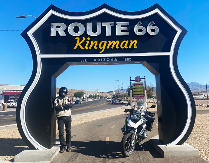
This ride-through photo stop in Kingman is located next to the Arizona Route 66 Museum.
Route 66 north and west of Oatman is a pure delight. The pavement is mostly smooth and intact, and it’s filled with sweeping turns and hairpins, many of which are nicely banked. There are several signs warning motorcyclists to stay aware, and these are best heeded. With the road gradually uncoiling, I made my way toward Kingman, passing several abandoned open-pit mines that dotted the rocky slopes and at least one small operating mine.
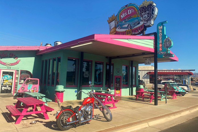
I was ready for a cup of coffee and some gas when I rolled into Kingman, where my father was an art teacher in the local school district before I was born. It is a clean and bustling small city fully embracing its Route 66 roots. I stopped at the colorfully adorned Mr. D’z Route 66 Diner and parked amidst historic cars, trucks, and motorcycles. As I chatted with my server over a hot cup of joe, she talked about the dual nature of the city. We were in the historic downtown district, but just a little ride up Interstate 40 is the modern district with chain hotels, restaurants, and thriving industry.
Across the street from the Route 66 Kingman sign is Mr. D’z Route 66 Diner, one of the many kitschy restaurants along the Mother Road that draw in curious, hungry travelers.
After rolling through the industrial zone in the Kingman outskirts, I headed northeast on the longest existing stretch of the Mother Road. Small roadside businesses dotted the path toward Peach Springs, each clearly embracing its Route 66 heritage with appropriate signage and vintage memorabilia. Historic gas stations were particularly interesting. While they no longer pumped fuel, they still oozed with the nostalgia of the road’s heyday.
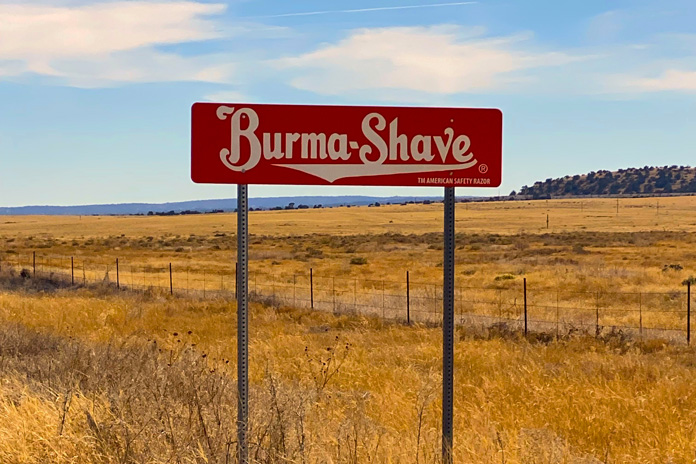
Between Peach Springs and Seligman: You can drive / A mile a minute / But there is no / Future in it / Burma-Shave.
After Peach Springs, I rode past three sets of Burma Shave signs with rhyming slogans, reminding me of childhood. As I rolled and swayed through the high grasslands, it was easy to imagine classic cars and motorcycles plying this portion of the route.
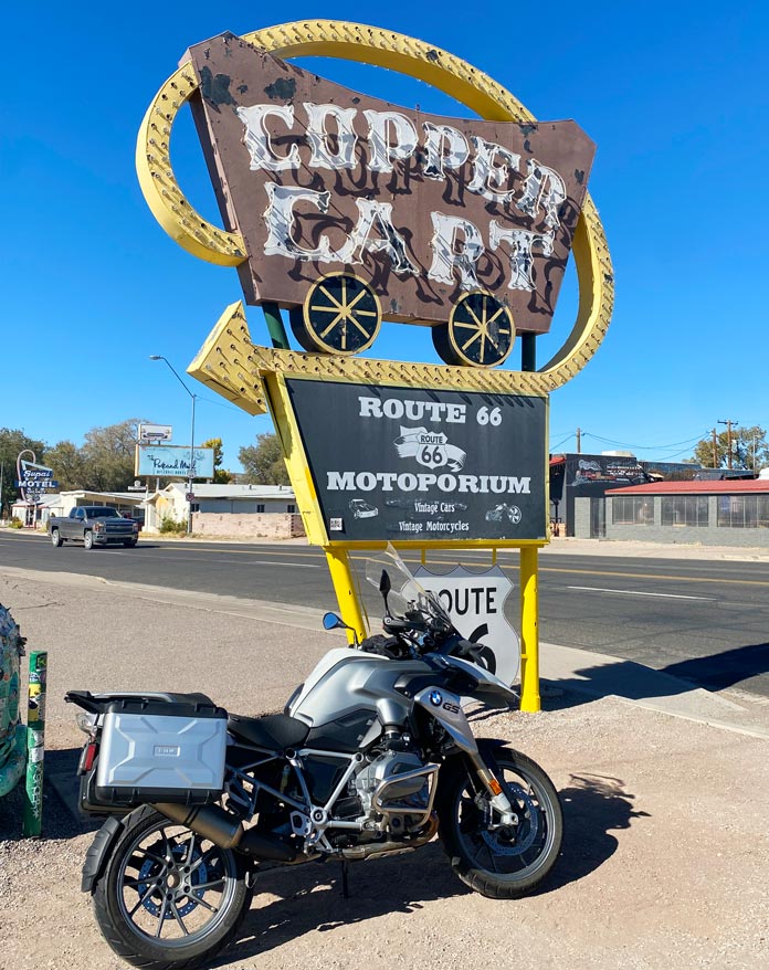
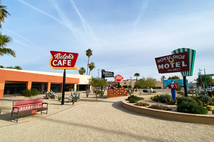
Formerly a restaurant that opened in 1952, the Copper Cart in Seligman is now a gift shop.
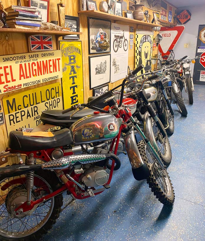
Entering Seligman was the most visually nostalgic part of my ride. This small town is a well-preserved tribute to its Route 66 heritage, with every shop, garage, and diner adorned with colorful signage and logos. Out of the corner of my eye, I saw a small sign for the Route 66 Motoporium. Not expecting much, I threw down my kickstand and walked into the Copper Cart to see what was inside. A bearded man said, “You look like a rider,” and pointed to a room in the back. It was filled with the motorcycles of my youth – both those that I rode and those that I ogled in the pages of motorcycle magazines of the 1960s and ’70s. Vintage Indians, Hondas, Hodakas, and Kawasakis, especially the 2-strokes, brought me back to the enchanting smell of premix laced with single-track dust that was a big part of my teenage life.
The Copper Cart in Seligman is home to the Route 66 Motoporium, a small museum full of vintage motorcycles and memorabilia.
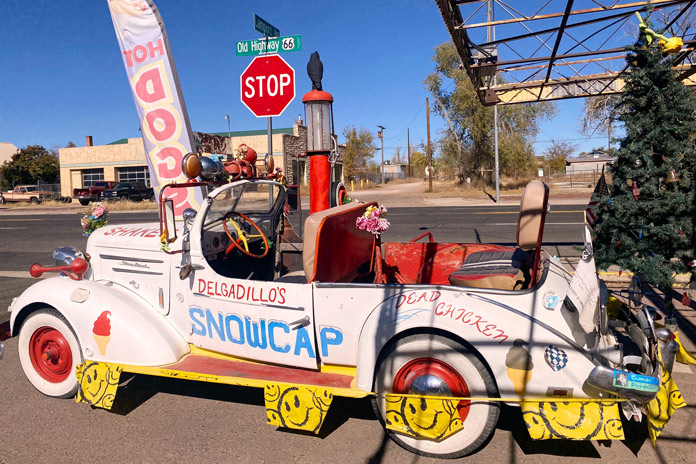
After a lengthy trip down moto-memory lane, it was time for lunch, and the legendary Delgadillo’s Snow Cap diner was just a block away. Juan Delgadillo and his wife, Mary, opened the Snow Cap in 1953, and Juan and his brother Angel formed the Historic Route 66 Association of Arizona. The Delgadillo family still owns and runs the historic diner, and I had a fantastic green chili burger and onion rings.
This 1936 Chevy is an eye-catching fixture in front of Delgadillo’s Snow Cap diner, a Route 66 institution in Seligman opened by Juan and Mary Delgadillo in 1953.
East of Seligman is a short stretch of the original Route 66 that runs into I-40 just before Ash Fork, and I noticed a few remnants of the Mother Road that are now spurs off the roadway. Beyond Ash Fork, much of Route 66 has been fully replaced with I-40, but there are still several towns that have embraced and preserved their historic Mother Road character.
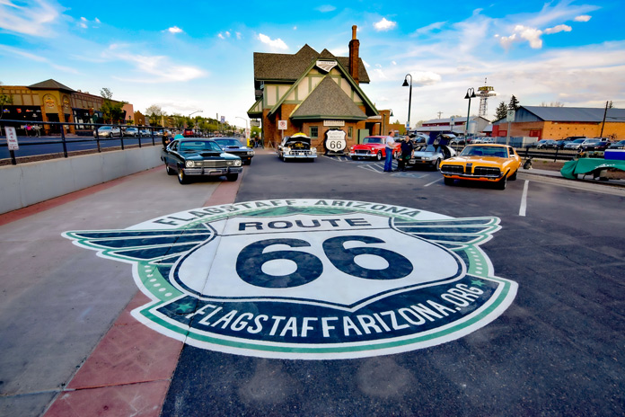
Route 66 runs through the heart of Flagstaff, a bustling city with great restaurants, bars, hotels, and nearby attractions like the Grand Canyon.
Williams, just off I-40, was the last town to be bypassed by the interstate, and it still teems with Route 66 charm. The main street is lined with historic stone buildings filled with antique stores, diners, and bars. I motored by one of the more famous watering holes, the Sultana Bar, which was opened in 1912, predating Route 66 by more than a decade.
After Williams, I-40 is as attractive as an interstate can be. Views of the San Francisco Peaks tower impressively to the north, and vibrant evergreens line the road. Flagstaff is the largest city on the Arizona portion of Route 66 and is home to my alma mater, Northern Arizona University. The original Route 66 skirted the beautiful campus just to the west and north.
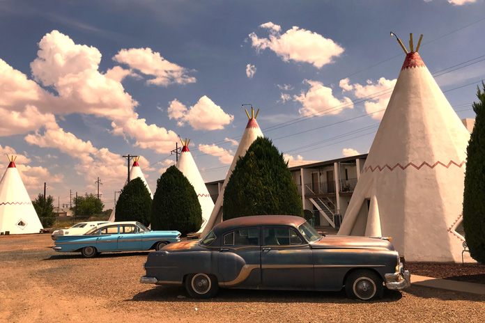
Built in 1950, the Wigwam Motel in Holbrook is a Route 66 icon.
Flagstaff boasts several original Mother Road attractions, including the historic downtown train station that houses the Flagstaff Visitor Center. On the way out of the city, I rolled past several diners that boast the Route 66 name, but my favorite is Miz Zip’s Route 66 Cafe. Then I felt the magnetic pull toward the Museum Club, an iconic Route 66 watering hole and one of my favorite college hangouts.
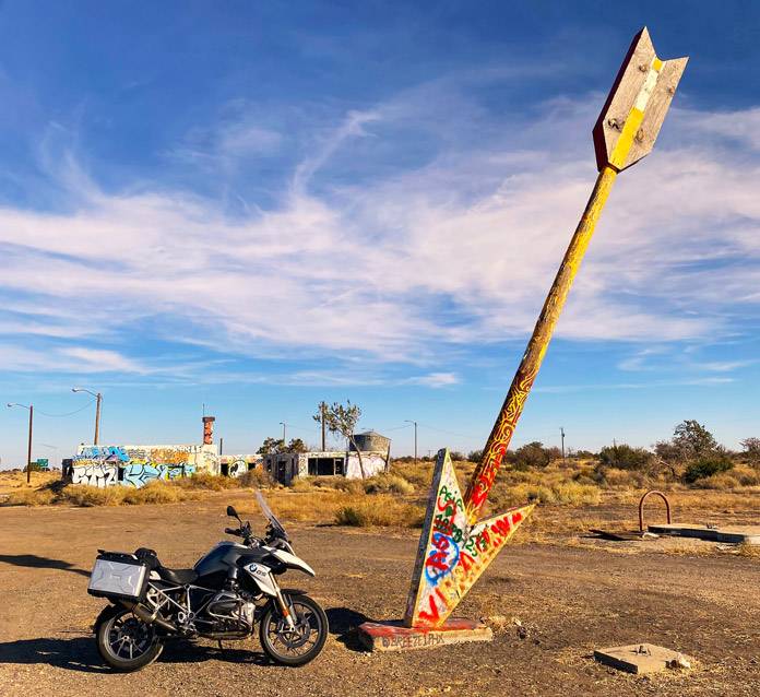
The majority of Route 66 east of Flagstaff has been replaced by I-40. While that is a shame, there is solace in the fact that many of the original attractions of the Mother Road era are still partially or fully intact on the way to the Arizona/New Mexico border. I took the short access road to the ruins of the Twin Arrows Trading Post. Up until very recently, both twin arrows still stood, but the ravages of weather and time toppled one. The trading post was a fixture on Route 66 since its opening in the late 1940s. Just across the freeway looms the new Twin Arrows Navajo Casino Resort.
Alas, only one arrow is still standing at the ruins of the Twin Arrows Trading Post between Flagstaff and Winslow.
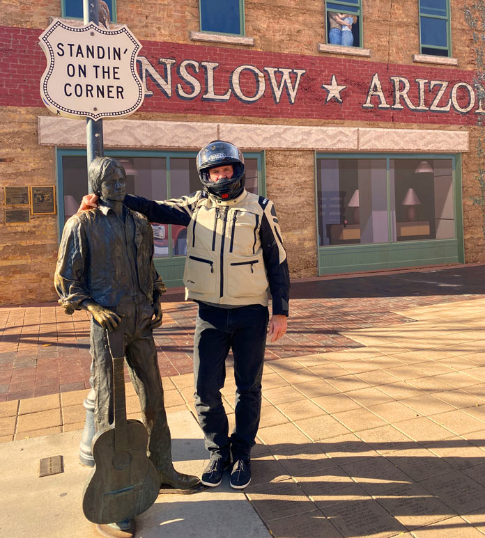
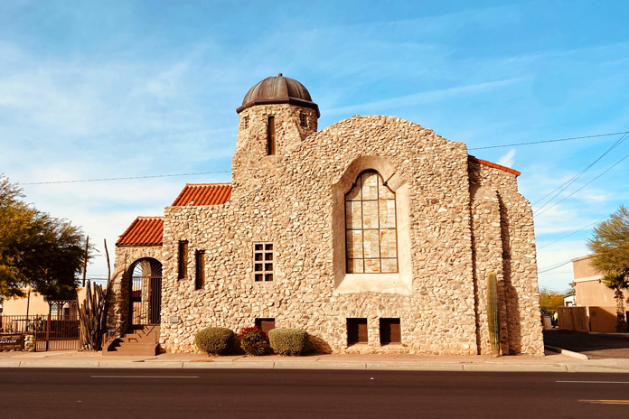
Riding another 30 minutes east on the interstate, I exited at Winslow, which sits on another existing stretch of Route 66. The loop into Winslow is festooned with various Route 66 advertisements. My first stop in town was to look at the impressive red sandstone St. Joseph’s Catholic Church. After snapping a photo at Standin’ on the Corner Park, I saddled up and headed to my lodging for the night, the beautifully restored La Pasada Hotel (see sidebar below).
At Standin’ on the Corner Park in Winslow, Arizona, the author stands with a bronze statue of a balladeer resembling Jackson Browne, who co-wrote the famous Eagles’ song “Take It Easy” with Glenn Frey.
After settling into my room, I walked the grounds of the beautiful rail-side resort before sitting with a post-ride cocktail and watching the trains roll by. Later that night, I strolled back into downtown Winslow for some shopping and a chili relleno dinner at the tiny Brown Mug Cafe. An unassuming photo on the wall beside my booth showed a youthful Harrison Ford sitting in the same spot many decades back (he’s an avid motorcyclist, by the way, and also owns a GS!).
Some motorcycles you’ll find on Route 66 have seen better days.
After a great night’s sleep, I had one last stretch to complete my Arizona Route 66 tour. I rode the few miles to Holbrook, which is the last of the original historic towns on my eastward stretch of Route 66 and home to the Wigwam Motel. From Holbrook, it’s another 74 miles on I-40 to the New Mexico border.
I highly recommend riding what you can of any portion of the Mother Road. This Arizona stretch of Route 66 is best ridden from late spring to early fall, as the winters in northern Arizona are cold and snowy. Pack for variable conditions, and enjoy your ride down memory lane.
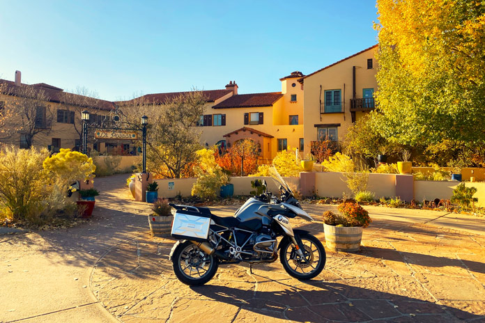
La Posada in Winslow is a crown jewel of the historic Fred Harvey railroad hotel empire. Designed in the 1920s by renowned architect Mary Elizabeth Jane Colter, it’s currently a first-class hotel, art gallery, and museum in an expansive garden setting. There is a gourmet restaurant on-site, and downtown Winslow is a short stroll away. The rooms are comfortable and well-appointed in a warm Southwestern motif, and photos of the hundreds of legendary actors and public figures who stayed at La Posada line the hallways. There is even safe designated motorcycle parking in front of the property. For more info, visit the La Posada website.
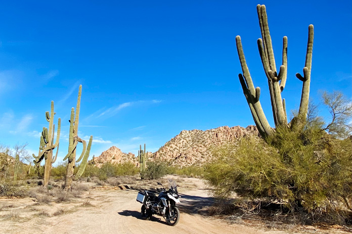
Nothing says “Arizona” like tall saguaros. These thorny towers are in the Sonoran Desert National Monument.
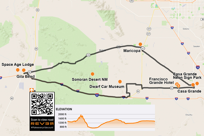
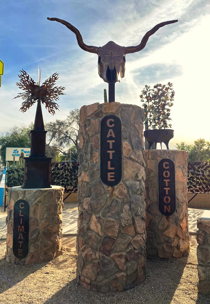
Arizona is known for its five Cs – copper, cattle, cotton, citrus, and climate – all of which are represented on the state’s great seal. I experienced three of them in abundance on this scenic southern Arizona loop, rolling past harvest-ready cotton fields and large dairy farms and enjoying spectacular weather. Two more Cs – cactus and cars – were also highlights of this entertaining ride.
Before you get the wrong impression from the title, I did not get locked up on this trip. “Big house” is the English translation of the Spanish “Casa Grande,” the starting and ending point of this loop ride. My trip began with a walk around the city’s downtown, which includes a tidy and interesting neon sign park, a nicely curated museum, a city park, and an impressive city square. Every January, the annual Historic Downtown Street Fair/Car and Bike Show draws upwards of 40,000 visitors to Casa Grande.
A roadside display in Casa Grande highlights some of the state’s foundational Cs.
After the stroll, I mounted my BMW R 1200 GS for the short ride to the Francisco Grande Hotel and Golf Resort. Tall palm trees stood sentinel as I rolled onto the resort’s beautiful property, which was established in the early 1960s as the spring training home of the San Francisco Giants. It was also a favorite haunt of John Wayne. After settling into my room and enjoying the incredible view, I had a delectable burger in the Duke’s Lounge and admired photos of Wayne, Willie Mays, Pat Boone, and other legendary visitors.
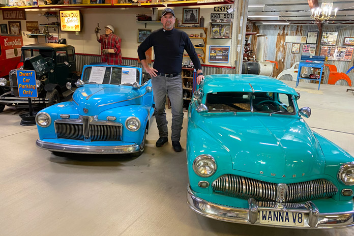
After a great night’s sleep, I mounted my GS and rode west through cotton fields and dairy farms to my first stop, the Dwarf Car Museum. The unassuming cluster of buildings belies the treasures displayed within. I paid my $5 entry fee and walked inside. At first glance, I could have been in any cool classic car museum, but as I got closer, the cars seemed to shrink.
The stunning and diminutive creations in the Dwarf Car Museum sit waist-high to the 6-foot-3 author. In addition to small cars, the museum also has an interesting collection of automotive memorabilia.
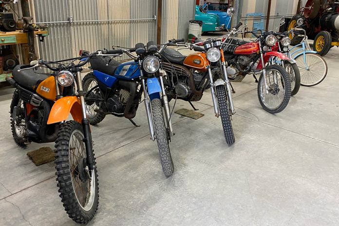
After scanning the whimsical, barn-like interior of the museum, I spotted a gentleman warming himself by a fire in the perfect man cave. Ernie Adams, the master builder of this eclectic and fascinating collection of diminutive classics, invited me to have a seat, and we had a nice chat about his life and his cars. Adams built his first dwarf car in the early ’60s, and they are about 11/16th scale. He bases every creation on a wheel size of 12 inches and miniaturizes everything else to that scale. Adams does not do much of the work anymore, but his son, daughter-in-law, and a friend carry on the tradition. He even has a tidy collection of vintage enduro bikes in a backroom.
What gearhead doesn’t have a soft spot for vintage Japanese dirtbikes?
Back on the GS, it was time to head to another C: the cactus-rich majesty of the Sonoran Desert National Monument, one of the most biologically diverse deserts in North America. Saguaros tower over the sand, each striking their own unique pose. With the rugged South Maricopa Mountains serving as the perfect backdrop, I explored a few established dirt roads off State Route 84.
On Interstate 8, I opened the throttle and made my westward ride through more of this desert grandeur. Interstates have never been my choice of roads, but this stretch of I-8 is as beautiful as they come. Various cactus varieties dot the rolling hills in the foreground, and distant mountain ranges create texture in the background.
The Casa Grande Neon Sign Park in the city’s downtown area preserves vintage neon signs from historic local establishments.
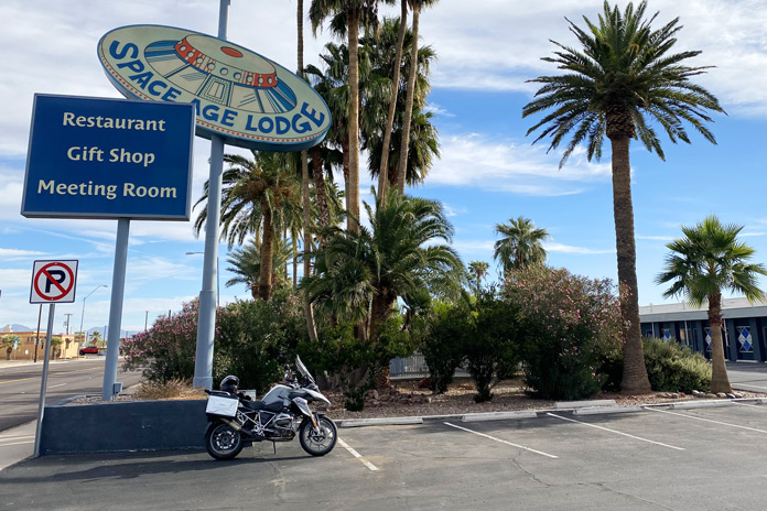
The ride west was relaxed and beautiful on the way to the final landmark on my list: the Space Age Lodge in Gila Bend. I have always been a fan of the rock band Rush, especially Neil Peart, who was arguably one of the greatest drummers in rock ‘n’ roll history. After tragically losing both his daughter and wife within a span of months, Peart rode his BMW GS more than 55,000 miles through North America, Mexico, and Belize, which he chronicled in his memoir, Ghost Rider: Travels on the Healing Road. One stop on Peart’s journey was the quirky, seemingly out-of-place Space Age Lodge, and I had to see it.
The music-loving author had to make a stop in Gila Bend to check out the Space Age Lodge, which was mentioned in Ghost Rider, Rush drummer Neil Peart’s amazing moto-centric memoir.
As I rolled out of town, one last incongruity caught my eye. Twin fighter jets crouched in front of a tiny airport on the outskirts of town. The pair of RF-101 Voodoos flew reconnaissance missions in Vietnam and now have a permanent home in Gila Bend.
It was time to head back to Casa Grande. Besides I-8, the other road that crosses the Sonoran Desert National Monument is State Route 238. This more northern road doesn’t have the towering saguaros of the interstate, but it is a relaxed desert ride with much less traffic.
The Museum of Casa Grande is housed in a beautiful Southwestern mission-style stone building. More than 40 buildings in the city are listed on historic registers.
This southern Arizona loop is best navigated from fall to early spring, as the desert temperatures are toasty in the summer. What it lacks in curves, it makes up for with a full plate of other entertaining Cs.
Bringing you the Best Motorcycle News from Around the Web!
We use cookies to ensure that we give you the best experience on our website. If you continue to use this site we will assume that you are happy with it.Ok