Tag Archives: Texas Motorcycle Rides

The Great Wide Open: Big Bend, Texas Motorcycle Ride

Big Bend Texas Motorcycle Ride
Riding through the Chisos Mountains in Big Bend National Park. (Photos by the author)

You’ve probably heard the saying “Everything’s bigger in Texas.” At 268,596 square miles, it’s by far the largest state in the Lower 48, outsizing California by more than 100,000 square miles. The 14 smallest states would fit comfortably within the borders of Texas with enough room left over for half of Tennessee.

Big Bend Texas Motorcycle Ride

Scan QR codes above or click Day 1 or Day 2 to view routes on REVER

When my buddy Eric Birns and I rode from Ventura, California, to San Antonio to see the solar eclipse last April, we got there in the most efficient way possible: 1,400 miles on Interstate 10 in two days. Efficient, yes, but not much fun, so we vowed that our return trip would be more scenic.

Due west of San Antonio is Big Bend National Park, a place that has long held fascination for me because its remote location limits the number of visitors. It’s also known to have good motorcycling roads.

Big Bend Texas Motorcycle Ride
One of Greg and Eric’s many smiling selfies during their fun, exploratory ride through Texas.

Big Bend is tucked into an area where the southerly course of the Rio Grande, which forms the park’s southern and eastern boundary as well as the border with Mexico, turns sharply to the north before cutting a wide arc to the east and then southeast on its way to the Gulf of Mexico.

Big Bend Texas Motorcycle Ride
The high-desert town of Alpine, Texas, is a great basecamp when visiting the Big Bend area.

From San Antonio, we rode west on U.S. Route 90, part of which runs close to the border through a parched, barren landscape. Following U.S. 90’s northward arc around Mexico, we gradually gained elevation until we reached Alpine, a small town that sits at 4,462 feet above sea level. As its name suggests, it often gets snow in the winter.

By the time we reached Alpine, Eric and I had traveled more than 2,300 miles over five days. We were traveling in style and comfort on Harley-Davidson’s latest touring bikes, Eric on a sharknosed Road Glide and me on a batwinged Street Glide. Both got modernized styling for 2024, and they’re equipped with a massive 12.3-inch TFT instrument panel paired with a state-of-the-art infotainment system (see sidebar). Our gear was packed into the Harleys’ saddlebags, chopped Tour-Paks, and Nelson-Rigg Traveler Tour/Lite Trunk Bags. We were the voices in each other’s heads thanks to a set of Cardo Packtalk Edge communicators.

Big Bend Texas Motorcycle Ride
A mural in downtown Alpine.

As we rode through Alpine, we passed the campus of Sul Ross State University, named after former Texas governor Lawrence Sullivan Ross. A colorful “Greetings from Alpine, Texas” mural downtown informed us that actor Dan Blocker, best known for his role as Hoss on the TV show Bonanza, is a Sul Ross alum. The university also has a leading collegiate rodeo program that has earned nine national championships.

After staying in a somewhat depressing Motel 6 in San Antonio (due to the popularity of the eclipse, affordable lodging near the path of totality was hard to come by), we were spoiled by the Hotel Parker at Quarter Circle 7, located on the west side of Alpine. It has clean, modern rooms with cloud-like beds, tasteful Western decor, and complimentary breakfast.

Big Bend Texas Motorcycle Ride
Alpine’s Hotel Parker at Quarter Circle 7 offers comfortable, well-appointed lodging and good food, drinks, and atmosphere at the Spicewood Bar and Restaurant.

During our weeklong road trip, Eric and I made it a tradition to end each day with a celebratory dinner. After getting cleaned up, we’d walk to a local restaurant, order a couple of frosty beers, and toast to our shared accomplishment and satisfaction of having explored new places and ridden unfamiliar roads. We’d send a selfie of us smiling and celebrating to our wives back home.

Next door to the Hotel Parker is the Spicewood Bar and Restaurant, which has a full bar and serves hearty West Texas fare in a lively atmosphere. We had the pleasure of dining with Eleazar Cano and Jayme Valles, two locals who run a motorcycle tour company called The Ride of Passage. They know the Big Bend area intimately, and they provided helpful routing suggestions. Jayme also runs a motorcycle repair shop called Alpine Motorsports, and he offered us roadside assistance should we need it.

Big Bend Texas Motorcycle Ride
Alpine locals Eleazar Cano and Jayme Valles are experts on the Big Bend area. They guide motorcycle tours, and Jayme’s motorcycle shop provides repair and towing services.

Big Bend could very well be called the Big Empty, and that’s a good thing. Brewster County, which encompasses Big Bend National Park and towns such as Alpine, Marathon, and Study Butte/Terlingua, covers 6,193 square miles but has less than 9,400 residents. If you want to avoid crowds, this is your place.

Wide-open spaces are what make the Big Bend area so appealing and unique. The Greater Big Bend International Dark Sky Reserve spans over 15,000 square miles in Texas and Mexico and is the largest Dark Sky Certified place in the world. Of course, as motorcyclists, we’re drawn to the roads that cut through those wide-open spaces. It’s an 80-mile ride through high desert from Alpine to the entrance to Big Bend National Park, and there’s very little civilization along the way (hence Jayme’s offer to help if we needed it).

Big Bend Texas Motorcycle Ride
Terlingua is a ghost town just outside of Big Bend National Park.

Before entering the park, we rode through Study Butte/Terlingua, a former mining town that’s now an eclectic mix of adventure outfitters (rafting, hiking, horseback riding, Jeep tours, etc.), unique lodging options, and a ghost town. There are bars, restaurants, and shops with a frontier vibe, as well as a world-famous chili cookoff every year.

We entered Big Bend National Park near Maverick Junction. There are several well-maintained paved roads that allow visitors to explore the park, but there are also extensive unpaved roads that provide access to backcountry campsites and other remote areas. We stuck to the tarmac and pointed our big Harleys east toward Chisos Basin.

Big Bend Texas Motorcycle Ride
Alpine, it’s an 80-mile ride on State Route 118 to reach the western entrance of Big Bend National Park near Maverick Junction.

In addition to its vastness, part of what makes Big Bend so special is its mix of landscapes – river, desert, and mountain environments comingle and create a canvas of rich colors and textures. Dominating the heart of the national park are the rugged Chisos Mountains, reaching a height of 7,825 feet at Emory Peak. 

We rode into the mountains on Chisos Basin Road, a steep, winding two-lane road that goes through a rugged canyon and summits a small pass before plunging into a high-elevation basin that’s surrounded by brown volcanic cliffs and peaks on three sides. The road ends at the floor of the 5,400-foot basin, where there is a visitor center, lodge, campground, trailheads, and other amenities.

Big Bend Texas Motorcycle Ride
The Rio Grande, the southern boundary of Big Bend National Park as well as the U.S./Mexico border, creates a corridor of green in the desert landscape.

After buying a few souvenirs, we climbed out of the basin and returned to the main road. We turned east and soon passed Panther Junction, where the park headquarters and a gas station are located. For the next 20 miles, we cruised under an endless blue sky on a long, gradual descent toward the Rio Grande. 

At Boquillas Canyon Overlook, we got our first view of the river. It flowed lazily and was surrounded by a corridor of vegetation that looked like a winding green carpet laid upon the arid desert landscape, with the rugged Sierra del Carmen escarpment forming a high brown wall on the Mexico side.

Big Bend Texas Motorcycle Ride
Riding on Ross Maxwell Scenic Drive near Santa Elena Canyon, where limestone cliffs rise above the Rio Grande on the Mexico side.

None of the paved national park roads create a loop, so we backtracked on the main road until we reached Santa Elena Junction and turned south on Ross Maxwell Scenic Drive. The road lives up to its name as it follows the western foothills of the Chisos Mountains with several fantastic overlooks, such as Sotol Vista and Mule Ears. Elevation drops as the road descends toward the Rio Grande and passes through Tuff Canyon. The pavement ends near an overlook where the river cuts through the high walls of Santa Elena Canyon.

See all of Rider‘s Texas touring stories here.

We had enjoyed every curve and vista in Big Bend National Park, but what eluded us – what I pictured in my mind’s eye when I imagined a park named after a famous river feature – was the experience of riding along with the river at our side. We found it next door.

Big Bend Texas Motorcycle Ride
Chisos Basin Road cuts through a scenic canyon as it winds through the Chisos Mountains. At the end of the road is a visitor center, motel, and campground.

Located west of Terlingua on Farm to Market 170, Big Bend Ranch State Park covers 311,000 acres (about one-third the size of the national park), and its southern boundary is the Rio Grande. Beyond Lajitas, FM 170 hugs the river closely, weaving and climbing and descending as it maneuvers around the rugged contours of the canyon. For pure riding enjoyment, the 50 roller-coaster miles from Lajitas to Presidio were a highlight of our entire 4,200-mile, nine-day trip.

Big Bend Texas Motorcycle Ride
FM 170 follows the Rio Grande through Big Bend Ranch State Park.

After gassing up in the sprawling border town of Presidio, we hightailed it north on U.S. Route 67 to Marfa and then east on U.S. 90 to Alpine. Another celebratory dinner at Spicewood was our reward for covering nearly 400 miles in one long day. While that pace suited us just fine, I recommend spreading a visit to the Big Bend area over a couple of days or longer so you can see more and include some excursions off the bike.

Big Bend Texas Motorcycle Ride
Near Rio Grande Village, this tunnel cuts through massive limestone beds.

The next day, we bid farewell to Alpine and rode north on State Route 118, which passes through the Chihuahuan Desert to Fort Davis, a small town that was once a frontier military post. The fort is a National Historic Landmark, and many of the old buildings have been restored. 

See all of Rider‘s South touring stories.

We continued riding north into the Davis Mountains, with the bright white buildings of the McDonald Observatory visible from in the distance. Perched at 6,800 feet, the University of Texas observatory takes advantage of the region’s dark skies to peer into the far reaches of the universe.

Big Bend Texas Motorcycle Ride
Santa Elena Canyon cuts through limestone cliffs.

After a pleasant ride through mountains, canyons, and high-desert vistas, SR-118 ended at Interstate 10, bringing our Big Bend journey to a close.

Big Bend Texas Motorcycle Ride
North of Alpine, SR-118 goes through the Davis Mountains and past the McDonald Observatory.

Getting to Big Bend isn’t easy. It requires commitment and, most likely, a long ride from somewhere distant. But it’s well worth the effort. It’s hard to believe such an enormous area can be hiding in plain sight, but things really are bigger in Texas.

See all of Rider‘s touring stories here.


SIDEBAR: Harley-Davidson Road/Street Glides

Big Bend Texas Motorcycle Ride

The Road Glide and Street Glide are Harley-Davidson’s most popular baggers. They’re essentially the same motorcycle except for their fairings: The RG has a frame-mounted sharknose fairing and the SG has a handlebar-mounted batwing fairing.

Updates for 2024 included modernized styling, lower weights, and a larger engine (117ci, up from 107) that makes more power and torque. The Glides are also some of the most high-tech Harleys ever. On the performance side, they have ride modes (Road, Sport, Rain, and Custom) and the Rider Safety Enhancements electronics suite, which includes linked brakes, cornering ABS, Drag Torque Slip Control, and Vehicle Hold Control. In the cockpit, they have a vibrant 12.3-inch touchscreen TFT display, an infotainment system managed by H-D’s Skyline OS, and a 200-watt audio system.

For our 1,400-mile superslab slog from California to Texas, the Glides provided good wind protection and a comfortable ride, aided in part by 43% more rear suspension travel (3 inches, up from 2.1). On curvy roads, such as the Twisted Sisters in the Texas Hill Country and roads throughout the Big Bend area, the Glides handled with confidence, stability, and grace. Their center of gravity is low, allowing them to bend through even the tightest curves with relative ease – and these are heavy machines (811 lb for the SG, 838 lb for the RG).

Harley-Davidson’s big Glides are better than ever. They produce plenty of grunt, they’re comfortable for long miles (we rode them 4,200 miles in nine days), and they strike a good balance between modern sophistication and classic style. You can read our full review here.


Big Bend, Texas Motorcycle Ride Resources

The post The Great Wide Open: Big Bend, Texas Motorcycle Ride appeared first on Rider Magazine.

Source: RiderMagazine.com

50 Best Motorcycle Roads in America

50 Best Motorcycle Roads in America 7. Pacific Coast Highway (California / 656 miles)
The Pacific Coast Highway is an iconic scenic road along the California, Oregon, and Washington coasts. (Photo by Kevin Wing)

The December 2024 issue of Rider celebrated the magazine’s 50th anniversary. Over the past half century, we have published thousands of travels stories, favorite rides, tour tests, and features highlighting must-ride roads throughout the U.S. and on every continent except Antarctica. As part of the special anniversary issue, we selected 50 of the best motorcycle roads in America.

Out of 3.9 million miles of roads in this country, these are just a drop in the bucket, covering a mere 13,467 miles. There are thousands more great roads out there, so get going!

(The road are listed more or less alphabetically by state rather than in rank order.)

1. Dalton Highway (Alaska / 414 miles)

50 Best Motorcycle Roads in America 1. Dalton Highway (Alaska / 414 miles)
1. Dalton Highway (Alaska / 414 miles)

Paralleling the Trans‑Alaska Pipeline, this gravel supply road that goes from Fairbanks to Prudhoe Bay is a bucket‑list adventure route that crosses the Arctic Circle and the Continental Divide. (Photo by Jeff Davison)

Related: Alaska Motorcycle Ride: Discovering America’s Last Frontier

2. Jasper Disaster Loop (Arkansas / 56 miles)

50 Best Motorcycle Roads in America 2. Jasper Disaster Loop (Arkansas / 56 miles)
2. Jasper Disaster Loop (Arkansas / 56 miles)

This route in the Ozark Mountains, which starts and ends in Jasper, Arkansas, and includes AR 7, AR 43, and AR 74, has hundreds of tight curves and crosses the Buffalo National River twice. (Photo by Bill Stermer)

Related: Riding the Backwoods of Arkansas

3. Pig Trail Scenic Byway (Arkansas / 20 miles)

50 Best Motorcycle Roads in America 3. Pig Trail Scenic Byway (Arkansas / 20 miles)
3. Pig Trail Scenic Byway (Arkansas / 20 miles)

The Ozarks offer a smorgasbord of roads that wind through dense hardwood forests, over scenic ridges, and along burbling rivers. This stretch of AR 23 is one of the region’s best. (Photo by Greg Drevenstedt)

Related: Riding Cross-Country on a BMW K 1600 B

4. Talimena National Scenic Byway (Arkansas, Oklahoma / 54 miles)

50 Best Motorcycle Roads in America 4. Talimena National Scenic Byway (Arkansas, Oklahoma / 54 miles)
4. Talimena National Scenic Byway (Arkansas, Oklahoma / 54 miles)

This winding road from Mena, Arkansas, (AR 88) to Talihina, Oklahoma, (OK 1) runs along the ridges of Rich Mountain and Winding Stair Mountain in Ouachita National Forest. (Photo by David Bell)

Related: The Best Motorcycle Ride in Eastern Oklahoma

5. Coronado Trail (Arizona / 123 miles)

50 Best Motorcycle Roads in America 5. Coronado Trail (Arizona / 123 miles)
5. Coronado Trail (Arizona / 123 miles)

U.S. 191 in eastern Arizona, which follows a trail used in 1540 by Spanish explorer Francisco Vasquez de Coronado, includes an open‑pit copper mine, high‑alpine meadows and ridges, and hundreds of curves. (Photo by Greg Drevenstedt)

Related: Favorite Ride: Arizona-New Mexico Loop

6. Arizona Routes 89/89A (Arizona / 131 miles)

50 Best Motorcycle Roads in America 6. Arizona Routes 89/89A (Arizona / 131 miles)
6. Arizona Routes 89/89A (Arizona / 131 miles)

From the Colorado Plateau to the red rocks of Sedona, through the historic towns of Jerome and Prescott, and across valleys and over mountains, these sibling state routes offer a greatest‑hits tour of central Arizona. (Photo by Kevin Wing)

Related: Expanding Your Horizons: Northern Arizona Loop Ride

7. Pacific Coast Highway (California / 656 miles)

50 Best Motorcycle Roads in America 7. Pacific Coast Highway (California / 656 miles)
7. Pacific Coast Highway (California / 656 miles)

Rides up and down CA 1 have been a regular part of Rider’s history since our first issue. This legendary road follows California’s rugged coastline and offers world‑class scenery and epic riding. (Photo by Kevin Wing)

Related: Savoring Summer Along California Route 1

8. Serpent to the Sea (California / 140 miles)

50 Best Motorcycle Roads in America 8. Serpent to the Sea (California / 140 miles):
8. Serpent to the Sea (California / 140 miles):

From U.S. 101 near Fortuna, riding east on this stretch of CA 36 passes through Grizzly Creek Redwoods State Park before turning into a fantastic roller coaster that seems like it will never end. (Photo by Greg Drevenstedt)

Related: Tracing the Cascades on a Yamaha Tracer 900 GT

9. Avenue of the Giants (California / 31 miles)

50 Best Motorcycle Roads in America 9. Avenue of the Giants (California / 31 miles)
9. Avenue of the Giants (California / 31 miles)

Paralleling U.S. 101, this meandering route (CA 254) passes through groves of old‑­growth coast redwoods that tower hundreds of feet above the road and follows the wild and scenic Eel River. (Photo by Greg Drevenstedt)

Related: Riding Among Giants

10. Million Dollar Highway (Colorado / 25 miles)

50 Best Motorcycle Roads in America 10. Million Dollar Highway (Colorado / 25 miles):
10. Million Dollar Highway (Colorado / 25 miles):

Mile for mile, this section of U.S. 550 between Ouray and Silverton, Colorado, is one of the most scenic anywhere. It passes through the rugged San Juan Mountains and summits several high passes. (Photo by Sara Liberte)

Related: Rediscovering Gold on the Million Dollar Highway

11. Mount Blue Sky Scenic Byway (Colorado / 28 miles)

50 Best Motorcycle Roads in America 11. Mount Blue Sky Scenic Byway (Colorado / 28 miles)
11. Mount Blue Sky Scenic Byway (Colorado / 28 miles)

Gaining more than 7,000 feet in 28 miles and achieving a final elevation of 14,130 feet, this is the highest paved road in North America, edging out Pikes Peak Highway by 15 feet. (Photo by Dan Schrock)

Related: A Tour Unlike Any Other: The Motorcycle Relief Project

12. Georgia Triangle (Georgia / 35 miles)

50 Best Motorcycle Roads in America 12. Georgia Triangle (Georgia / 35 miles)
12. Georgia Triangle (Georgia / 35 miles)

This north Georgia loop connects GA 60, GA 180, and U.S. 129 and circumnavigates Blood Mountain. A highlight is the Two Wheels of Suches motorcycle resort. (Photo by Phil Buonpastore)

Related: Riding the Georgia Triangle

13. Salmon River Scenic Byway (Idaho / 160 miles)

50 Best Motorcycle Roads in America 13. Salmon River Scenic Byway (Idaho / 160 miles)
13. Salmon River Scenic Byway (Idaho / 160 miles)

Idaho is full of scenic byways. This one follows the Salmon River through the Sawtooth Mountains and crosses the Continental Divide at 7,014‑foot Lost Trail Pass. (Photo by Clement Salvadori)

Related: 35 Bucket List Motorcycle Rides

14. Route 66 (Illinois, Missouri, Oklahoma, Texas, New Mexico, Arizona, California / 2,448 miles)

50 Best Motorcycle Roads in America 14. Route 66 (Illinois, Missouri, Oklahoma, Texas, New Mexico, Arizona, California / 2,448 miles)
14. Route 66 (Illinois, Missouri, Oklahoma, Texas, New Mexico, Arizona, California / 2,448 miles)

Dubbed the “Mother Road” by John Steinbeck in The Grapes of Wrath, U.S. Route 66 was once the shortest, fastest, and most scenic route from Chicago to Los Angeles. (Photo by Mark Tuttle)

Related: Get Your Kickstart on Route 66

15. Kentucky Coal Route (Kentucky / 218 miles)

50 Best Motorcycle Roads in America 15. Kentucky Coal Route (Kentucky / 218 miles)
15. Kentucky Coal Route (Kentucky / 218 miles)

This coal country loop follows Daniel Boone’s Wilderness Road, summits 4,145‑­foot Black Mountain, and includes U.S. 421, made famous by the 1958 Robert Mitchum movie Thunder Road. (Photo by Lance Oliver)

Related: Coal, Country and Curves | Eastern Kentucky Motorcycle Tour

16. Red River Gorge Scenic Byway (Kentucky / 46 miles)

50 Best Motorcycle Roads in America 16. Red River Gorge Scenic Byway (Kentucky / 46 miles)
16. Red River Gorge Scenic Byway (Kentucky / 46 miles)

Following the wild and scenic Red River, this byway passes through a National Geologic Area that features stone arches, caves, cliffs, ravines, waterfalls, and the Nada Tunnel. (Photo via Adobe Stock/erhlif)

Related: Great American Scenic Byways Tour

17. Park Loop Road (Maine / 27 miles)

50 Best Motorcycle Roads in America 17. Park Loop Road (Maine / 27 miles)
17. Park Loop Road (Maine / 27 miles)

This scenic road around Acadia National Park on Maine’s Mount Desert Island features woodlands, rocky beaches, and glacier‑scoured granite peaks such as Cadillac Mountain. (Photo by Scott A. Williams)

Related: Riding Maine’s Rugged, Winding Coast

18. Rangeley Lakes National Scenic Byway (Maine / 52 miles)

50 Best Motorcycle Roads in America 18. Rangeley Lakes National Scenic Byway (Maine / 52 miles)
18. Rangeley Lakes National Scenic Byway (Maine / 52 miles)

Considered one of the most scenic routes in New England, this byway in the Appalachian Mountains of western Maine winds through woodlands and around lakes and ponds. (Photo by Alan Paulsen)

Related: Onward to Madawaska, Maine: Motorcycling in Search of the Elusive Moose

19. Copper Country Trail (Michigan / 47 miles)

50 Best Motorcycle Roads in America 19. Copper Country Trail (Michigan / 47 miles)
19. Copper Country Trail (Michigan / 47 miles)

This byway follows the Keweenaw Peninsula, which extends like a dorsal fin from Michigan’s Upper Peninsula into Lake Superior. Near Copper Harbor, Brockway Mountain Drive provides sweeping views. (Photo by Chuck Cochran)

Related: A Michigan Upper Peninsula Motorcycle Ride in Autumn

20. Tunnel of Trees Scenic Heritage Route (Michigan / 20 miles)

50 Best Motorcycle Roads in America 20. Tunnel of Trees Scenic Heritage Route (Michigan / 20 miles)
20. Tunnel of Trees Scenic Heritage Route (Michigan / 20 miles)

This section of M‑119, which runs along the edge of Lake Michigan between Harbor Springs and Cross Village, is a narrow, curvy path through a tunnel of foliage. (Photo by Jamie Elvidge)

Related: Great Lakes Getaway: Touring Minnesota, Wisconsin and Michigan

21. Historic Bluff Country Scenic Byway (Minnesota / 88 miles)

50 Best Motorcycle Roads in America 21. Historic Bluff Country Scenic Byway (Minnesota / 88 miles)
21. Historic Bluff Country Scenic Byway (Minnesota / 88 miles)

This scenic byway (MN 16) in southern Minnesota begins at the Mississippi River and continues west through the Root River Valley, curving through rolling hills, dolomite bluffs, and historic towns. (Photo by Chuck Cochran)

Related: Beauty in Bluff Country: A Southern Minnesota Motorcycle Ride

22. Great River Road National Scenic Byway (Minnesota, Wisconsin, Iowa, Illinois, Missouri, Kentucky, Tennessee, Arkansas, Mississippi, Louisiana / 2,069 miles)

50 Best Motorcycle Roads in America 22. Great River Road National Scenic Byway (Minnesota, Wisconsin, Iowa, Illinois, Missouri, Kentucky, Tennessee, Arkansas, Mississippi, Louisiana / 2,069 miles)
22. Great River Road National Scenic Byway (Minnesota, Wisconsin, Iowa, Illinois, Missouri, Kentucky, Tennessee, Arkansas, Mississippi, Louisiana / 2,069 miles)

This legendary road touches 10 states as it follows the mighty Mississippi River from its headwaters in Minnesota to its sprawling delta in Louisiana. (Photo via Adobe Stock/Ferrer Photography)

Related: Beauty in Bluff Country: A Southern Minnesota Motorcycle Ride

23. Natchez Trace Parkway (Mississippi, Alabama, Tennessee / 444 miles)

50 Best Motorcycle Roads in America 23. Natchez Trace Parkway (Mississippi, Alabama, Tennessee / 444 miles)
23. Natchez Trace Parkway (Mississippi, Alabama, Tennessee / 444 miles)

This national parkway from Natchez, Mississippi, to Nashville, Tennessee, follows the “Old Natchez Trace” used by Native Americans, European settlers, traders, and soldiers. (Photo by Tim Kessel)

Related: Motorcycle Riding Along the Natchez Trace Parkway

24. Going‑to‑the‑Sun Road (Montana / 50 miles)

50 Best Motorcycle Roads in America 24. Going‑to‑the‑Sun Road (Montana / 50 miles)
24. Going‑to‑the‑Sun Road (Montana / 50 miles)

Traversing Glacier National Park, this road cuts through the rugged Rocky Mountains and crosses the Continental Divide at 6,646‑foot Logan Pass. (Photo by Sherry Jones)

Related: Yellowstone to Glacier on Montana Highway 89

25. North Carolina Route 28 (North Carolina / 81 miles)

50 Best Motorcycle Roads in America 25. North Carolina Route 28 (North Carolina / 81 miles)
25. North Carolina Route 28 (North Carolina / 81 miles)

Starting at Deals Gap and ending at the Georgia state line, this wonderfully curvy road is known as Moonshiner 28 and includes part of the Mountain Waters Scenic Byway. (Photo by Trevor Denis)

Related: Healing Ride: A Father-and-Son Journey on the Blue Ridge Parkway and Beyond

26. Blue Ridge Parkway (North Carolina, Virginia / 469 miles)

50 Best Motorcycle Roads in America 26. Blue Ridge Parkway (North Carolina, Virginia / 469 miles)
26. Blue Ridge Parkway (North Carolina, Virginia / 469 miles)

This national parkway through the Appalachian highlands is the quintessential scenic ride and is known for its perfectly shaped curves, well‑maintained pavement, and countless scenic overlooks. (Photo by Steven Goode)

Related: Motorcycle Travel Along the Blue Ridge Parkway

27. Kancamagus Highway (New Hampshire / 35 miles)

50 Best Motorcycle Roads in America 27. Kancamagus Highway (New Hampshire / 35 miles)
27. Kancamagus Highway (New Hampshire / 35 miles)

NH 112 is a spectacular road that twists its way through New Hampshire’s White Mountains. In the fall, it’s one of New England’s best leaf‑peeper routes. (Photo by Dan Bisbee)

Related: White Mountain Escape: Riding the Kancamagus Highway

28. Mount Washington Auto Road (New Hampshire / 8 miles)

50 Best Motorcycle Roads in America 28. Mount Washington Auto Road (New Hampshire / 8 miles)
28. Mount Washington Auto Road (New Hampshire / 8 miles)

This short toll road to the top of 6,288‑foot Mount Washington is often fraught with bad weather. A recorded wind speed of 231 mph on the summit was a world record until 1996. (Photo by Clement Salvadori)

Related: Riding the Best of the White Mountains in New Hampshire

29. Enchanted Circle Scenic Byway (New Mexico / 84 miles)

50 Best Motorcycle Roads in America 29. Enchanted Circle Scenic Byway (New Mexico / 84 miles)
29. Enchanted Circle Scenic Byway (New Mexico / 84 miles)

Circling 13,167‑foot Wheeler Peak, this scenic loop includes valleys, mesas, mountains, national forests, and some of New Mexico’s most culturally rich towns and villages. (Photo by Tim DeGiusti)

Related: An Old West Motorcycle Tour to 3 Haunted Hotels

30. Great Continental Divide Route (New Mexico, Colorado, Wyoming, Idaho, Montana / 2,767 miles)

50 Best Motorcycle Roads in America 30. Great Continental Divide Route (New Mexico, Colorado, Wyoming, Idaho, Montana / 2,767 miles)
30. Great Continental Divide Route (New Mexico, Colorado, Wyoming, Idaho, Montana / 2,767 miles)

This mostly off‑road route crosses five states on its way from the U.S.-Mexico border to Banff, Canada. It’s a serious undertaking by any measure. (Photo by Don Mills)

Related: Riding Across the Great Divide

31. U.S. Route 50 in Nevada (Nevada / 409 miles)

50 Best Motorcycle Roads in America 31. U.S. Route 50 in Nevada (Nevada / 409 miles)
31. U.S. Route 50 in Nevada (Nevada / 409 miles)

Dubbed “The Loneliest Road in America” by Life magazine, the Nevada portion of the transcontinental Lincoln Highway traverses basin‑and‑range topography and follows the Pony Express route. (Photo by Greg Drevenstedt)

Related: Riding the Backbone of America: U.S. 50

32. Upper Delaware Scenic Byway (New York / 70 miles)

50 Best Motorcycle Roads in America 32. Upper Delaware Scenic Byway (New York / 70 miles)
32. Upper Delaware Scenic Byway (New York / 70 miles)

This section of NY 97 hugs the eastern shore of the Delaware River and passes through protected park land. A highlight is the winding Hawk’s Nest portion carved into the cliffside. (Photo by Kevin Wing)

Related: Reservoir Roads: Exploring the New York Southern Highlands

33. Triple Nickel (Ohio / 62 miles)

50 Best Motorcycle Roads in America 33. Triple Nickel (Ohio / 62 miles)
33. Triple Nickel (Ohio / 62 miles)

OH 555 often ranks high on lists of great motorcycle roads, and the 21 miles between Chesterhill and Ringgold are particularly fun and challenging. Part of Ohio’s Windy 9, it’s in a target‑rich environment. (Photo by Ken Frick)

Related: Riding Ohio’s Triple Nickel

34. Mount Hood Scenic Byway (Oregon / 105 miles)

50 Best Motorcycle Roads in America 34. Mount Hood Scenic Byway (Oregon / 105 miles)
34. Mount Hood Scenic Byway (Oregon / 105 miles)

Starting at the Columbia River, this route winds around its namesake peak, an 11,249‑foot active volcano, and goes through gorges, rainforests, and pastoral valleys. (Photo by Greg Drevenstedt)

Related: Tracing the Cascades on a Yamaha Tracer 900 GT

35. West Cascades Scenic Byway (Oregon / 220 miles)

50 Best Motorcycle Roads in America 35. West Cascades Scenic Byway (Oregon / 220 miles)
35. West Cascades Scenic Byway (Oregon / 220 miles)

Following the contours of the Cascades range, this route treats riders to old‑­growth forests, snowcapped volcanic peaks, and the wild and scenic Clackamas River. (Photo by Greg Drevenstedt)

Related: Tracing the Cascades on a Yamaha Tracer 900 GT

36. PA Route 6 (Pennsylvania / 427 miles)

50 Best Motorcycle Roads in America 36. PA Route 6 (Pennsylvania / 427 miles)
36. PA Route 6 (Pennsylvania / 427 miles)

U.S. 6 across northern Pennsylvania, known locally as PA Route 6, takes riders through lush forests and charming small towns. Highlights include the PA Wilds region, the Kinzua Sky Walk, and the Susquehanna River. (Photo by Kenneth W. Dahse)

Related: Cruising the Pennsylvania Wilds on U.S. Route 6

37. Iron Mountain Road (South Dakota / 17 miles)

50 Best Motorcycle Roads in America 37. Iron Mountain Road (South Dakota / 17 miles)
37. Iron Mountain Road (South Dakota / 17 miles)

This stretch of U.S. 16A, which connects Custer State Park with Mount Rushmore in the Black Hills of South Dakota, includes 314 curves, 14 switchbacks, and three wooden “pigtail” bridges. (Photo by Kevin Wing)

Related: Riding South Dakota’s Black Hills BDR-X

38. Tail of the Dragon (Tennessee, North Carolina / 11 miles)

50 Best Motorcycle Roads in America 38. Tail of the Dragon (Tennessee, North Carolina / 11 miles)
38. Tail of the Dragon (Tennessee, North Carolina / 11 miles)

This (in)famous section of U.S. 129, which borders Great Smoky Mountains National Park, claims 318 curves in just 11 miles. It’s a wild ride, but its popularity results in weekend crowds. (Photo by Ken Frick)

Related: Riding ‘Shine Country: The Tail of the Dragon and North Carolina’s Moonshiner 28

39. Cherohala Skyway (Tennessee, North Carolina / 43 miles)

50 Best Motorcycle Roads in America 39. Cherohala Skyway (Tennessee, North Carolina / 43 miles)
39. Cherohala Skyway (Tennessee, North Carolina / 43 miles)

Completed in 1996 at a cost of $100M, this road through the Cherokee and Nantahala national forests (hence the name) has perfectly radiused corners, smooth pavement, and stunning views. (Photo via Adobe Stock/Mark Nortona)

Related: Favorite Ride: Space Coast to the Smokies

40. Texas FM 170 (Texas / 50 miles)

50 Best Motorcycle Roads in America 40. Texas FM 170 (Texas / 50 miles)
40. Texas FM 170 (Texas / 50 miles)

Farm to Market 170 from Lajitas to Presidio is a scenic roller coaster along the Rio Grande, which serves as the U.S.-Mexico border and the southern boundary of Big Bend Ranch State Park. (Photo by Greg Drevenstedt)

Related: A West Texas Motorcycle Ride Through Hill Country, Big Bend, and Oil Wells

41. Twisted Sisters (Texas / 132 miles)

50 Best Motorcycle Roads in America 41. Twisted Sisters (Texas / 132 miles)
41. Twisted Sisters (Texas / 132 miles)

Connecting Ranch Roads 335, 336, and 337 is a scenic, sometimes challenging ride through Texas Hill Country. Popular with bikers, the route includes several motorcycle‑friendly bars and shops. (Photo by Greg Drevenstedt)

Related: Twisted Sisters: The Texas Hill Country’s Most Famous Trio

42. Utah Scenic Byway 12 (Utah / 123 miles)

50 Best Motorcycle Roads in America 42. Utah Scenic Byway 12 (Utah / 123 miles)
42. Utah Scenic Byway 12 (Utah / 123 miles)

UT 12, aka A Journey Through Time Scenic Byway, connects state parks, Bryce Canyon and Capitol Reef national parks, Grand Staircase‑Escalante National Monument, and Dixie National Forest. (Photo by Greg Drevenstedt)

Related: Southwest Touring Ride on a 2013 Victory Vision Tour

43. Skyline Drive (Virginia / 105 miles)

50 Best Motorcycle Roads in America 43. Skyline Drive (Virginia / 105 miles)
43. Skyline Drive (Virginia / 105 miles)

This national parkway, which begins near the northern end of the Blue Ridge Parkway, runs along mountain ridges for the entire length of Virginia’s Shenandoah National Park. (Photo by Scott A. Williams)

Related: Muriel’s First Ride

44. Back of the Dragon (Virginia / 32 miles)

50 Best Motorcycle Roads in America 44. Back of the Dragon (Virginia / 32 miles)
44. Back of the Dragon (Virginia / 32 miles)

VA 16 from Marion to Tazewell runs north‑south over three mountains that give the road a rolling humpbacked character, and its 32 miles have more than 400 curves. (Photo courtesy Back of the Dragon)

Related: Appalachians Motorcycle Ride: Backroads Bonanza

45. Vermont Route 100 (Virginia / 217 miles)

50 Best Motorcycle Roads in America 45. Vermont Route 100 (Virginia / 217 miles)
45. Vermont Route 100 (Virginia / 217 miles)

Stretching from Massachusetts to the Canadian border, VT 100 parallels the Green Mountains and passes through woodlands, pristine farmland, and charming villages. (Photo by Dan Bisbee)

Related: Riding Vermont Route 100 From Massachusetts to Memphremagog

46. North Cascades Scenic Highway (Washington / 140 miles)

50 Best Motorcycle Roads in America 46. North Cascades Scenic Highway (Washington / 140 miles)
46. North Cascades Scenic Highway (Washington / 140 miles)

Part of the larger Cascades Loop, WA 20 includes old‑­growth forests, cascading waterfalls, alpine lakes, glaciers, and rugged mountain scenery. (Photo by Clement Salvadori)

Related: Rocketing Through the Cascades on Triumph’s Rocket III Touring

47. Door County Coastal Byway (Wisconsin / 66 miles)

50 Best Motorcycle Roads in America 47. Door County Coastal Byway (Wisconsin / 66 miles)
47. Door County Coastal Byway (Wisconsin / 66 miles)

This scenic loop on the Door Peninsula includes views of Lake Michigan, Green Bay, the Niagara Escarpment bluffs, and quaint shore‑­side towns and villages. (Photo by Barry Mellen)

Related: Destination Door County

48. Coal Heritage Trail (West Virginia / 97 miles)

50 Best Motorcycle Roads in America 48. Coal Heritage Trail (West Virginia / 97 miles)
48. Coal Heritage Trail (West Virginia / 97 miles)

This National Scenic Byway through West Virginia’s coal country includes twisty roads up and over ridges, easy valley riding, small towns, and the New River Gorge Bridge. (Photo by Steve Shaluta)

Related: Top 5 Motorcycle Roads in West Virginia 

49. U.S. Route 33 in West Virginia (West Virginia / 248 miles)

50 Best Motorcycle Roads in America 49. U.S. Route 33 in West Virginia (West Virginia / 248 miles)
49. U.S. Route 33 in West Virginia (West Virginia / 248 miles)

One of the highest‑rated motorcycle roads in the Mountain State, U.S. 33 passes through George Washington and Monongahela national forests and the Shenandoah Valley. (Photo by Nathan Cuvelier)

Related: Favorite Ride: Seneca Rocks, West Virginia

50. Beartooth Highway (Wyoming, Montana / 69 miles)

50 Best Motorcycle Roads in America 50. Beartooth Highway (Wyoming, Montana / 69 miles)
50. Beartooth Highway (Wyoming, Montana / 69 miles)

U.S. 212 between Red Lodge, Montana, and Yellowstone National Park in Wyoming summits 10,947‑foot Bearfoot Pass. Journalist Charles Kuralt called it the most scenic highway in America. (Photo by James Petersen)

Related: Road to Wisdom: A U.S. and Canadian Rockies Motorcycle Tour

The post 50 Best Motorcycle Roads in America appeared first on Rider Magazine.

Source: RiderMagazine.com

Get Your Kickstart on Route 66

Get Your Kickstart on Route 66
John Alger rides the historic U.S. Route 66 from Chicago, Illinois, to Amarillo, Texas, on his kickstart-only 1978 Yamaha SR500.

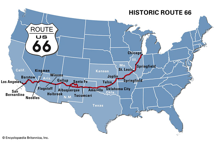
Dubbed the “Mother Road” by John Steinbeck in The Grapes of Wrath and known as “Main Street USA,” U.S. Route 66 will celebrate its 100th anniversary in 2026. No other road in America had such an impact on growth, migration, transportation, and popular culture. During the Great Depression and the horrific Dust Bowl of the 1930s, Route 66 was a paved pathway to a better life, transporting tens of thousands of people from the heartland to the West.

Get Your Kickstart on Route 66
Map of Route 66 courtesy of Encyclopedia Brytannica

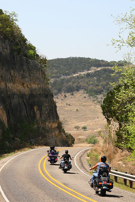
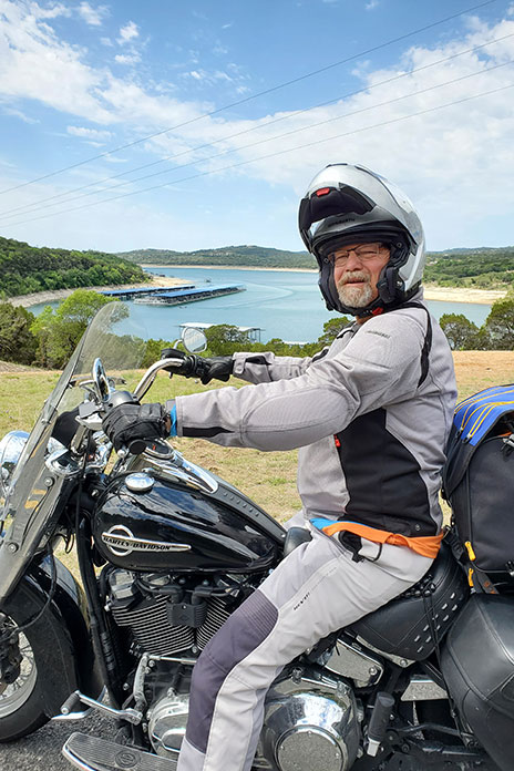
Right after WWII, my Uncle Don traveled from California to his hometown of Springfield, Illinois, using much of Route 66 and riding a kickstart, air-cooled, single-cylinder AJS. As I pondered my own journey on the Mother Road, it seemed fitting to attempt it on my 1978 Yamaha SR500, which is also an air-cooled, kickstart Single. Over the years, I have owned several Yamahas, but the SR500 has been my preferred ride for its light weight, effortless cornering ability, competent disc brakes, and simple but elegant design. I like it so much, I own two.

Get Your Kickstart on Route 66
The author’s 1978 Yamaha SR500 on Route 66 in Tulsa, Oklahoma.

For my trip, I chose the one with 30,000 miles on the odometer. Except for upgraded brake hoses, it was bone stock. To get it ready for my Route 66 adventure, I gave it a complete engine and chassis overhaul, as well as a 535cc big bore kit, an oil cooler, and a SuperTrapp exhaust. I retained the stock air box and K&N air filter but re-jetted it as required. The new chain and sprockets were one tooth larger on the countershaft, which lowered cruising rpms and resulted in a mostly vibration-free ride.

Related: 2015 Yamaha SR400 Review | First Ride

The SR500 also has a no-frills CDI ignition system with a strong charging system, allowing me to keep my cellphone and Bluetooth full of juice, and a centerstand, a must-have for daily chain lubrication and fixing flat tires (I had one).

Get Your Kickstart on Route 66
U.S. Route 66 begins in Chicago, Illinois, within sight of the Willis Tower (formerly the Sears Tower).

Find out more about the First 100 Miles of Route 66

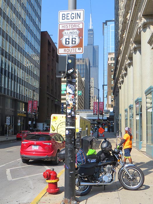
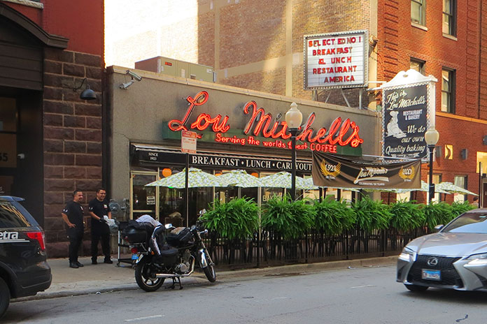
Since Route 66 starts in Chicago, I transported my bike from my hometown of Merritt Island, Florida, in my Chevy van. The first day of riding started in Chicago rush-hour traffic on the Kennedy Expressway, which was undergoing road construction, but after stop-and-go for two hours in record heat, I was rewarded with the U.S. 66 “Begin” sign at the corner of Adams Street and Michigan Avenue across from The Art Institute of Chicago. Just a few blocks away is the Willis Tower (formerly the Sears Tower), and a few blocks farther is the famous Lou Mitchell’s restaurant, which is over 100 years old and served a great breakfast to start my trip.

Get Your Kickstart on Route 66
Lou Mitchell’s is a legendary eatery in downtown Chicago.

Aside from the sweltering temperatures and humidity of August, Chicago’s beautiful residential areas and parks made the short trip to the suburbs quite pleasant. The first 100 miles of Route 66 is known as the Heritage Corridor, which also includes towns along the Illinois & Michigan Canal, which connected Lake Michigan to the Illinois River, and Starved Rock State Park. In Cicero, I stopped to see one of Al Capone’s houses. In Berwyn, I checked out the world’s largest laundromat, which is over 13,000 square feet and even has a bird aviary, and I also passed by one of the oldest-operating White Castle restaurants.

Get Your Kickstart on Route 66
Dick’s on 66 is located in Joliet, Illinois.

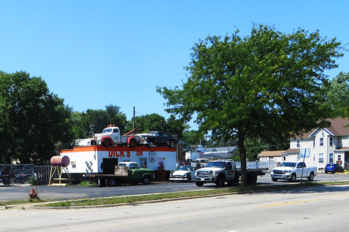
Traveling south, I found a neat roadside display in the town of Joliet called Dick’s on 66, an old towing shop decorated with several vintage vehicles and a patch of bricks purportedly from the original Route 66. Across the street is a restored gas pump and ice-cream shop. Joliet is also the home of the state prison and was featured in the 1980 movie The Blues Brothers.

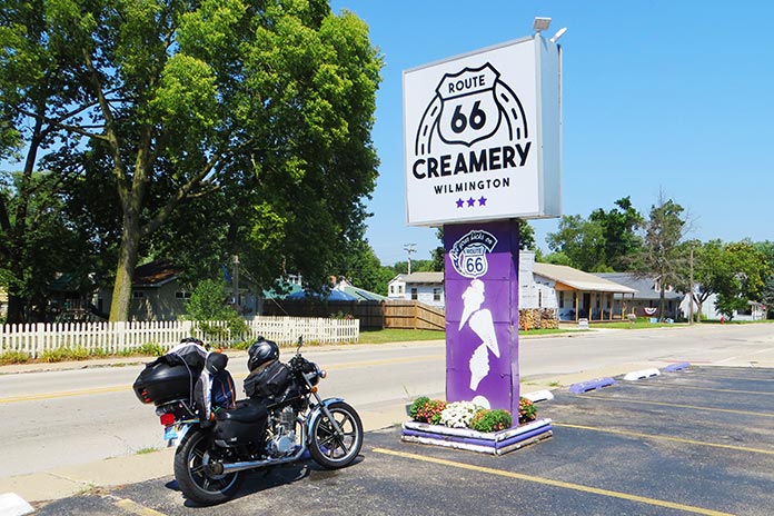
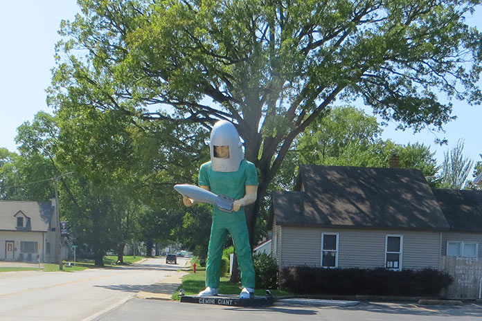
In Wilmington, Illinois, I cooled down with a sundae at the Route 66 Creamery and spotted the first of five “giants” I would see on my trip: a Sinclair dinosaur on the roof of G&D Tire Company.

Get Your Kickstart on Route 66
Route 66 Creamery is in Wilmington, Illinois.

For this trip, I tried to take the oldest sections possible of Route 66, and Illinois had them clearly marked. Some sections of road looked more like abandoned driveways, with weeds growing through cracks in the concrete. My little SR500 was perfect for this kind of duty.

Get Your Kickstart on Route 66
One of the few remaining Muffler Men is located in Wilmington, Illinois. The bright green Gemini Giant holds a silver rocket and was named in honor of the Gemini space program of the 1960s.

In Towanda is Dead Man’s Curve, a sharp curve that caught many drivers unaware and was the site of numerous accidents from the 1920s to the 1950s. There’s even a preserved series of Burma Shave signs that say: Around the curve / lickety-split / beautiful car / wasn’t it? I had a 25-plus mph headwind for most of that first day, and it felt as if I was riding into a blow drier. My first night was spent at the Ghost Hollow Lodge in Chandlerville, Illinois, where I fortified myself with a dinner of venison and fresh veggies.

On the second day, I stopped in Springfield to cool down with an iced tea at Route 66 Motorheads Bar & Grill, which also has a museum and gaming room. Just south of Springfield in Carlinville, my fun was interrupted by a flat tire. I had packed tools, tire irons, a portable compressor, and a tube patch kit, but my tube was too badly mangled by the nail. Scott McDaniels of S&S ATV came to the rescue by delivering a new tube (at no charge), a local resident across the street brought me ice water, and the local city hall allowed me to do the work on the north side of their office in the shade on the concrete. It just goes to show how kind strangers can be when you are in a bind.

Get Your Kickstart on Route 66
The Old Chain of Rocks Bridge is located in Granite City, Illinois.

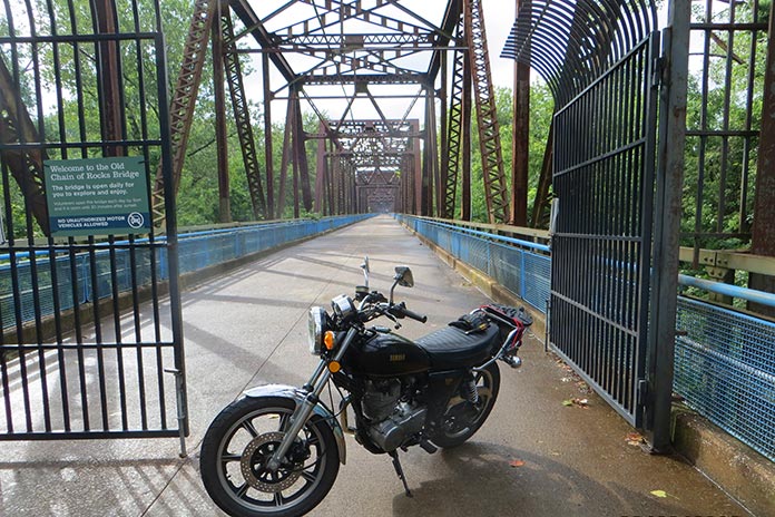
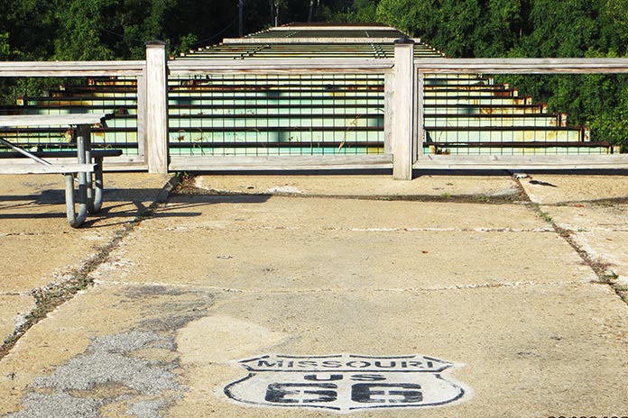
The repair set me back almost four hours, and I had to bypass many of the Route 66 sights from Carlinville to St. Charles, Missouri, where I stayed with friends. The following day, I unloaded my luggage and backtracked to Granite City, Illinois, to see the Old Chain of Rocks Bridge. The mile-long bridge was part of the original Route 66 from 1936 to 1965 and allowed motor vehicles to cross the Mississippi River from Illinois to Missouri. It features a 30-degree turn partway through. I had gone over this bridge in a car as a kid before it was decommissioned in 1968. It is now only open to foot traffic and bicycles.

Get Your Kickstart on Route 66
The 630-foot Gateway Arch in St. Louis, Missouri, was completed in 1965.

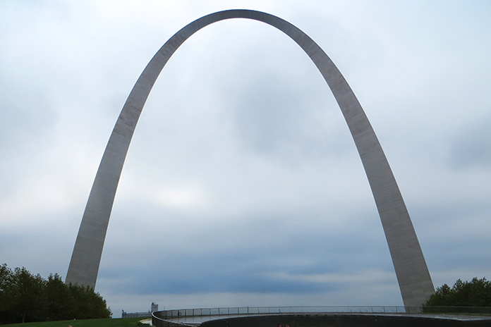
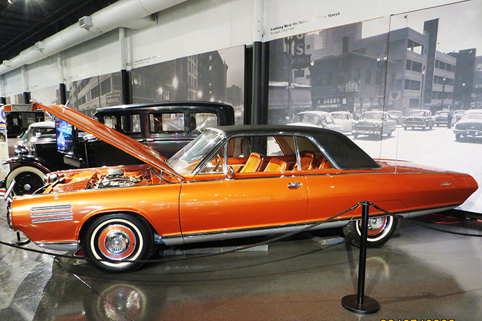
While in St. Louis, I also went up into the 630-foot Gateway Arch, which was completed in 1965. It is now part of the National Park Service, and with recent remodeling and upgrades, it’s a not-to-miss experience. I also visited the National Museum of Transportation on the west side of St. Louis. This may be one of the best transportation museums in the country and has the only remaining GM Aerotrains. It also has a running Chrysler Turbine Car like the one at the Henry Ford Museum in Michigan.

Get Your Kickstart on Route 66
A Chrysler Turbine Car at the National Museum of Transportation in St. Louis.

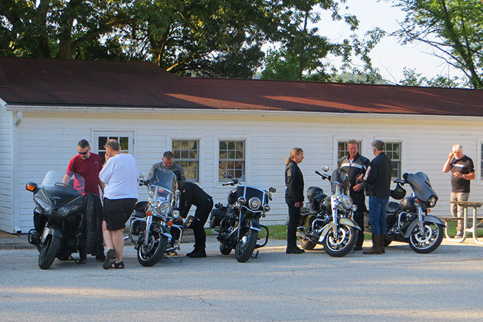
After getting my luggage loaded back on the SR500, my next stop was Times Beach, Missouri. Route 66 used to cross the Meramec River there, and the remnants of the bridge are still there, along with a Route 66 State Park. I met some folks from Europe riding Route 66 on rented Harleys, and they were aghast that I was attempting to make the same trip on my antique bike with no GPS navigation and only an EZ66 guide in my tankbag.

Get Your Kickstart on Route 66
Remnants of the Route 66 bridge in Times Beach, Missouri.

Times Beach was the site of the second largest EPA Superfund site due to a local contractor spraying dioxin on the dirt roads for dust control. All the buildings were bought by the EPA and leveled, and it’s currently considered a ghost town. West of Times Beach is the Meramec Caverns, where I ran into my new European friends again. My bike would do roughly 100 miles per tank of fuel, which coincided with my body’s need to stand up and stretch out a bit and suck down a cold beverage.

Get Your Kickstart on Route 66
A group of Europeans riding Route 66 on rented Harleys stopped at the Route Route 66 State Park in Missouri.

I stayed at the KOA in Springfield, Missouri, that night and rented a cabin. I had planned on renting a primitive campsite, but for only about $40 more, I got an air-conditioned cabin, lights, electricity, a mattress, a table, and a TV. It was a bargain!

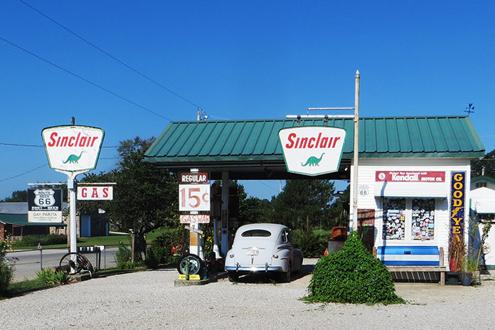
Along the way in Missouri are a few museums and stops such as a replica 1930s Sinclair station called Gary’s Gay Parita in Ash Grove, Missouri, where the sign reads “Gas Wars” and advertises fuel at 15 cents per gallon. Another sign reads “Kendal, your 2,000 mile oil!” We have certainly come a long way!

Get Your Kickstart on Route 66
A replica 1930s Sinclair gas station called Gary’s Gay Parita in Ash Grove, Missouri.

Shortly after the Sinclair station on the Old Route 66 trail, I crossed an old truss bridge that crossed over Johnson Creek in Spencer, Missouri. Like the old sections of Route 66 in Illinois, this section looked like an abandoned road going into the backwoods. It was beautiful.

Get Your Kickstart on Route 66
Only 13 miles of Route 66 pass through Kansas.

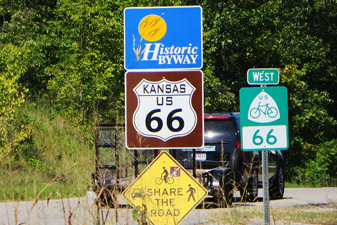
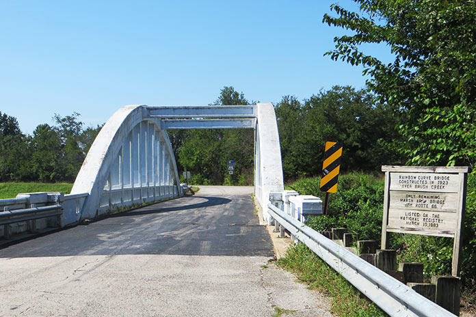
Kansas only has a very short 13-mile section of the Old Route 66 path, and if you take that, you are blessed with crossing one of the few remaining Marsh Arch bridges left in the country – and the only remaining one on Route 66, this one having been built in the early 1900s.

Get Your Kickstart on Route 66
The Rainbow Curve Bridge was built in 1923. It’s the only remaining Marsh Arch bridge on Route 66.

Oklahoma likely has the most Route 66 sites of any state. After the road was decommissioned by the federal government for use as a federal highway, Oklahoma named it State Road 66. It’s easy to follow, although I did manage to miss a sign and ride maybe 50 miles off course. The best Route 66 Museum is in Clinton, Oklahoma. It covers the initial planning and construction of the route, along with different scenes of Americana, a video of the Dust Bowl, and more.

Get Your Kickstart on Route 66
Buck Atom, a 21-foot-tall space cowboy in Tulsa, Oklahoma, is one of the iconic Muffler Men of Route 66.

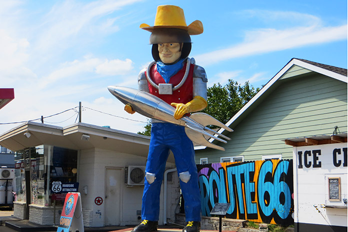
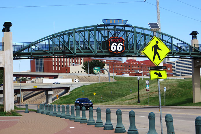
There are more giant statues to be seen as you pass through Oklahoma, including Buck Atom, the 21-foot-tall space cowboy in Tulsa holding a rocket. Tulsa also has a cool park downtown called the Cyrus Avery Centennial Plaza that has three tall old neon motel signs relocated there from the early days of Route 66. Further south is a Route 66 village with an old train, a gas station, and an oil derrick.

Get Your Kickstart on Route 66
Route 66 in Tulsa, Oklahoma.

The last section of Route 66 I rode in Oklahoma was a mostly abandoned concrete road that paralleled Interstate 40, but you could tell it was part of the original route. How many mostly abandoned four-lane concrete highways going into nowhere with no traffic do you see? At one point, I thought I was off-track, but then I saw the Texas state sign and the familiar white outlined Route 66 logo painted on the road.

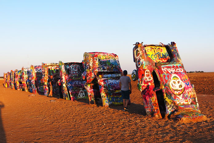
In Texas, much of Route 66 is access highways on either side of the interstate, which worked just fine for my trusty mule since I could travel at more relaxed speeds in the intense heat. Along the way, you pass by the Leaning (water) Tower of Britten in Groom, Texas, and Amarillo gives you the Cadillac Ranch.

Get Your Kickstart on Route 66
Cadillac Ranch is located in Amarillo, Texas.

After visiting the Cadillac Ranch, I stopped at a KOA, and when I tried to start my bike again, it didn’t fire up. It turned out to be an issue with the ignition system, and despite having the parts from my other SR500 shipped to me to attempt a repair, it didn’t take. I cut my trip short and loaded the bike in the back of a Penske truck and headed back east.

In spite of a flat tire, intense heat and humidity, and an ignition failure, this was the most fun I can recall in most of my life. In retrospect, I should have tried making this trip on a newer bike, but part of the fun was riding a kickstart antique.

If you are considering riding this road, I would suggest waiting until 2026 for the 100-year anniversary since I heard plans in various towns along the way for some centennial events, so it should be even better.

ROUTE 66 RESOURCES:

The post Get Your Kickstart on Route 66 appeared first on Rider Magazine.

Source: RiderMagazine.com

A West Texas Motorcycle Ride Through Hill Country, Big Bend, and Oil Wells

West Texas Motorcycle Ride Big Bend National Park
Bending though curves in Big Bend.

The seeds of this West Texas motorcycle ride were planted in December 2019 when my buddy Reed and I joined the EagleRider Club. Members pay monthly subscription fees for credits toward motorcycle rentals, which roll over month to month and offer significant discounts versus standalone rentals.

In addition to the discounts, being club members allows us to fly into a new area and rent motorcycles that are different from what we ride back home. We live in Connecticut, so flying into Dallas saved us a 3,200-mile roundtrip that would have taken several days on each end. Instead of grinding out miles just to get to Texas and back home, we spent that time leisurely exploring roads and sights.

West Texas Motorcycle Ride

Scan QR code above or click here to view the route on REVER

To beat the heat of the Texas summer, we planned our trip for mid-April. Reed and I are BMW riders, but for this trip we rented two late-model Harley-Davidsons: a Street Glide for me and a Heritage Softail Classic for him. There’s something special about riding the open road on a big American V-Twin. We’re older guys who were decked out in textile riding gear and modular helmets, so we’re hardly Easy Rider rebels. When we saw a BMW GS in a hotel parking lot with “Adventure Before Dementure” on one of its panniers, we could relate.

West Texas Motorcycle Ride
Words to live by.

See all of Rider‘s Harley-Davidson coverage here.

We did a clockwise loop of roughly 2,300 miles over nine days. From Dallas, we headed south to Texas’ funky state capital, Austin. The Harleys were stable and comfortable, the torque was intoxicating, and the horns were good and loud, but the transmissions were a bit clunky. After visiting the Texas Capitol, we rode east to Round Top, a small tourist town known for antiques. We were disappointed to find the antique markets closed when we got there, but I managed to get a photo with a roadrunner as tall as I am – things really are bigger in Texas!

West Texas Motorcycle Ride Harley-Davidson Street Glide Heritage Softail Classic
West Texas is wide open.

The riding improved west of Austin when we entered the legendary Texas Hill Country, an area well-known among motorcyclists. Endless hills turn the many rural FM (Farm-to-Market) and RM (Ranch-to-Market) roads into paved rollercoasters. We enjoyed nice twisties, light traffic, and pretty views along the shore of Lake Travis and through Inks Lake State Park. After riding through Llano, we dropped the sidestands and stretched our legs at Enchanted Rock State Natural Area. In Fredericksburg, a charming historic town surrounded by vineyards, we ate sausages and enjoyed live music during a courtyard dinner at a German restaurant. 

Less than an hour from Fredericksburg and west of Medina, we rode the renowned Twisted Sisters. The three RM roads (335, 336, and 337) are full of fun curves and whoop-de-doos and are worthy of their reputation. The Twisted Sisters are so popular among motorcyclists that there are two-wheeled tourist stops in the area, like the Lone Star Motorcycle Museum in Vanderpool and the Frio Canyon Motorcycle Stop and The Hog Pen in Leakey. We passed many ranches; two of my favorite names were Big Bucks Ranch and Middle Age Spread.

West Texas Motorcycle Ride Hill Country Twisted Sisters
Enjoying rolling curves through Texas Hill Country, home of the famous Twisted Sisters.

After a night in Del Rio, we followed U.S. Route 90 west along the southwestern border of the Texas Pecos Trail region and within a stone’s throw of the Rio Grande. Although our bikes had the same 107 engines, the Softail’s tank holds 5 gallons while the Street Glide’s holds 6 gallons. That 1-gallon difference became evident when we hit an 86-mile stretch with no services thinking we had enough gas. We were wrong.

West Texas Motorcycle Ride Harley-Davidson Heritage Classic
Reed enjoyed riding his rented Harley-Davidson Heritage Classic.

Reducing speed and tucking in behind the windshield for the last 20 miles did the trick, but headwinds meant the Softail was running on fumes when we pulled into Sanderson. At the gas station, a lady with a ’50s-style bouffant told us that pickle juice is good for combating dehydration. We were intrigued, but we wondered if she was having fun at the expense of us Yankees.

See all of Rider‘s touring stories here.

At Marathon, we turned south toward our next destination: Big Bend National Park. Situated in a pocket of West Texas where the Rio Grande’s southeasterly course makes a sharp bend to the north, Big Bend is enormous, covering more than 801,163 acres (1,252 square miles), making it the seventh largest national park outside of Alaska. In 1976, Big Bend was designated a UNESCO Biosphere Reserve. It contains the largest intact portion of the Chihuahuan Desert, one of the most biologically rich and diverse desert ecosystems in the world.

West Texas Motorcycle Ride Big Bend National Park
Located in West Texas where the Rio Grande turns sharply to the north, Big Bend National Park protects part of the Chihuahuan Desert.

Because Big Bend is far from major cities and the 118 miles of the Rio Grande along its southern boundary serves as the border between the U.S. and Mexico, it receives relatively few visitors compared to other national parks. That makes it the perfect destination for those who love wide-open spaces and don’t care for crowds.

West Texas Motorcycle Ride
Wildflowers were blooming during our April ride.

That afternoon we enjoyed Big Bend in all its glory. Mountain peaks topping 7,000 feet competed with colorful desert blooms for beautiful scenery. In Rio Grande Village, we learned of a tramway system that transported lead and silver from Mexico across the Rio Grande to eventually connect with the railroad in Marathon. For migrants, crossing the Rio Grande would have been a matter of simply wading the low waters, but passing the Border Patrol checkpoint some miles inland (in open desert) is another story.

West Texas Motorcycle Ride
The U.S.-Mexico border.

Highlights of Big Bend National Park include the winding road up to Chisos Basin, the Rio Grande Overlook, and Ross Maxwell Scenic Drive, which passes through Tuff Canyon on its way to Santa Elena Canyon Overlook. Of the 304 miles of roads in the park, 123 miles are paved, 45 miles are unpaved but improved, and 136 miles are unpaved and primitive, so there are plenty of miles to explore regardless of your preferred surface – or bike. That said, at our hotel in Alpine, located about 80 miles north of the park via State Route 118, another guest recounted how two Honda Africa Twins struggled in Big Bend’s sandy unpaved tracks, going down so often they gave up and had their bikes towed out.

West Texas Motorcycle Ride Rio Grande Santa Elena Canyon
The Rio Grande’s Santa Elena Canyon.

After spending the morning at Fort Davis, a national historic site north of Alpine with a well-preserved complex of buildings and visitor center, we embarked on our most challenging ride of the trip. We headed south on State Route 17 to Marfa and then took U.S. Route 67 to Presidio. From there, we rode east on FM 170, known as River Road. The 64 miles to Study Butte-Terlingua wind along the Rio Grande through Big Bend Ranch State Park. Except for the low water crossings, the road surface is generally good – and the views are fantastic – but riders need to stay frosty because there are sudden elevation changes, decreasing radius and off-camber blind curves, and sometimes wildlife on the road.

West Texas Motorcycle Ride Fort Davis
Fort Davis was a frontier military post from 1854-1891.

After getting our fill of mountains, canyons, rivers, and memorable Rio Grande scenery, we headed north through empty high desert to Fort Stockton, Odessa, Midland, and Lubbock, an area of Texas notable for the Permian Basin, an 86,000-square-mile area that’s home to some of the nation’s largest oil reserves. We rode for hours with oil wells scattered across the landscape in every direction. To our surprise, we also saw dozens of large wind turbines towering above some of the oil rigs, so some Texans are clearly hedging their bets. 

Just south of Amarillo, we visited Palo Duro Canyon State Park, where we took in expansive views of America’s second largest canyon, which is 120 miles long, an average of 6 miles wide, and up to 1,000 feet deep. The sprawling canyon was the subject of paintings by Georgia O’Keefe, who lived nearby, and the site of a battle between Texas Rangers and Chief Kicking Wolf in Larry McMurtry’s novel Comanche Moon.

West Texas Motorcycle Ride Palo Duro Canyon
Located near Amarillo, Palo Duro Canyon is the second largest canyon in America.

Having completed much of our loop, we headed southeast toward Dallas. We took secondary roads through towns such as Turkey and Matador, the latter being the home of Bob’s Oil Well, a vestige of the days when bold roadside architecture attracted customers – in this case a wooden oil derrick towering above a gas station.

West Texas Motorcycle Ride
Everything is bigger in Texas. Words to live by.

The skies darkened as we rode east, and in Crowell, a lady pulled over to tell us there were tornados touching down near our next waypoint in Vernon. When an EMT reiterated the warning, we stayed put until the coast was clear. When we finally hit the road again that evening, it was a wet ride, but there was so much lightning arcing across the clouds in the distance that we had plenty of light to guide us. When we checked into our hotel in Wichita Falls, we learned they’d had heavy rain, wind, and golf ball-sized hail – one guest had a broken windshield to prove it.

West Texas Motorcycle Ride Big Bend Ranch State Park
FM 170, known as River Road, winds its way along the northern side of the Rio Grande between Presidio and Terlingua and forms the southern boundary of Big Bend Ranch State Park.

On our last day, we blasted along state highways to Dallas, and for long stretches, we enjoyed explosions of color from roadside wildflowers. Bluebonnet and Indian paintbrush were abundant, and mid-April was the perfect time to see them. We know better than to mess with Texas, but we sure do appreciate all the wonderful roads, sights, and beauty we experienced in the Lone Star State. And thanks, EagleRider, for renting us the Harleys – they were the perfect steeds for our journey.

The post A West Texas Motorcycle Ride Through Hill Country, Big Bend, and Oil Wells first appeared on Rider Magazine.
Source: RiderMagazine.com