Improving slow-speed stability can be fun. No, really.
This “slow race” broke out after lunch with fellow riders and was just for fun. But it’s actually a great way to build skills.
More than any other skill, riders tell me they wish they had better low-speed control. And no wonder; a bike is unstable and heavy at low speeds. It’s a skill riders want to improve, yet most avoid practice. Why? Probably because we tend to avoid things we hate. Unfortunately, we can’t avoid slow-speed riding altogether.
For me, the trick to developing skills has always been to make practice fun. So, let’s play a game or two. But first, let’s consider the basic techniques of slow-speed riding. Sit straight up with eyes looking to a distant target. Place the bike in first gear, raise the engine rpm slightly over idle and ease the clutch into the friction zone. Once rolling, place your feet on the pegs and apply a little rear brake. Modulate your speed by applying more or less rear brake (no front brake!). Those are the basics of slow riding. Now, let’s have some fun.
When riding with friends, try an impromptu “slow race” at one of your breaks. Line everyone up side-by-side at one end of an open parking lot, all facing the same direction and with sufficient space between bikes. This will be your start line. Pick a finish line a few yards away or so (not too far). On the “go” signal, each rider starts toward the finish, riding as slowly, but as stably, as possible. The last one to get to the finish line wins. The first one there buys lunch.
Once comfortable with straight line slow-speed control, try introducing a game with turns. A favorite of mine is to pick another willing rider and begin riding in a circle together at slow speed. Let the bike lean beneath you as you stay upright. Keep eyes up and looking at your buddy across the circle. As you get more comfortable, the two of you can tighten the circle to challenge each other. End the game by steering out of the circle, away from your buddy.
Then there’s the two-wheeled version of follow-the-leader. With riders in single file, one rider leads the group around the lot, making random combinations of right and left turns and even large circles, while keeping speeds slow enough to require the clutch to remain in the friction zone.
With such games, you’ll spend more time enjoying yourself than being intimidated by the bike’s slow-speed behavior. And before you know it, you’ll be riding like Heinz ketchup: smooth and slow.
Setting up camp in New York’s Catskill Mountains with some showers in the forecast, so the tent rain fly goes on before hitting the sack. Photo by Kenneth Dahse.
Everyone knows the potential benefits and joys of camping out. Spectacular unfiltered views of the sky, sunsets and stars, communing with nature and friends by the campfire and sharing simple, tasty meals surrounded by trees, wildlife, mountains or the open desert…it’s all out there. Camping avoids costly hotels, too, so you can ride longer for less, and it lets you plan riding routes into backcountry you might not otherwise be able to reach. The shared effort and cooperation of roughing it with friends also enhances your group’s camaraderie, creating stronger bonds and great memories.
Of course, camping is a bit more complicated than whipping out a credit card at the Dew Drop Inn. Everything we need and take for granted in our homes or in hotels has to come with you on the bike, right down to the roof over your head. Car campers have it easy–there’s generally plenty of room, so less thought has to go into what to bring. But despite a limited amount of space on a motorcycle, with a little forethought and ingenuity you can enjoy both a great ride and a memorable camping trip.
Primitive, dry camping takes more effort and planning, but the payoff can be secluded beauty like this spot on the Sea of Cortez in Baja, Mexico. Photo by Steven M. Green.
Assuming you’re a total newbie to motorcycle camping, consider picking a spot for your first overnight that has water, toilets, trash cans, picnic tables, fire rings and/or grills, like an established campground. Dry, primitive camping can be awesome and the only kind available in some really wonderful places, but in addition to carrying your own water for washing and drinking, you’d be surprised how inconvenient the lack of a simple raised table can be for some people, not to mention doing your business in the bushes and packing out your trash. Of course, a dark pit toilet in a campground is still an adventure at 3 a.m., but at least you’ve got a door and somewhere to sit (just remember that if something falls in there, it’s probably staying!).
When your living quarters is a tent, the presence of simple conveniences like a table for organizing your gear can make a huge difference in your camping comfort level. Photo by Steven M. Green.
It also helps if there’s a camp store or host nearby who can provide bulky things like charcoal and firewood, which you can strap to the bike after it’s unloaded at the campsite. Depending on the motorcycle’s capacity and if you’re riding solo or two-up, you may also want to skip the pre-organized meals and simply buy something for dinner and breakfast at the closest store to the campground and bungee it on in some way. You’d be amazed how much space you can find when you’re hungry and thirsty! Bring or buy soft-sided insulated bags that fold flat for transporting cold beverages or hot food, and try to leave some space in your bike’s luggage for your purchases when you pack the bike at home.
Using a liner bag in the bike’s top trunk makes it easy to remove and strap to the passenger seat, freeing up trunk space for vittles and such purchased close to camp. Photo by Mark Tuttle.
How much and what type of camping gear to bring really boils down to personal preference and how much you can fit on the bike without overloading it and upsetting its handling. You can’t go wrong by buying the lightest, most compact gear that will work for the conditions–backpacking equipment, for example, often works well, particularly when space is at a premium. It can be expensive, though, and there’s no point in shelling out big bucks for an ultra-lightweight tent when you’re riding solo on a big touring bike with a full set of luggage. Don’t compromise on quality, though–cheap tents leak and can be hard to set up, and bulky, inexpensive sleeping bags and pads are never as warm or comfortable as promised. Here’s a basic list to get you started:
Tent
Ground cover or tent footprint
Sleeping bag
Sleeping pad, air mattress or cot
Stake mallet/puller
Camp chair
LED headlight/lantern
Small stove/coffee pot or JetBoil
Cup/spork
Water bottle
Multitool/knife
Towel/soap/cleansing wipes
Windproof matches/lighter
Kindling or campfire starter
First aid kit
Bug repellant, sunscreen, hat
Choose wisely, and most of this stuff should fit in a waterproof duffel you can strap on the back of the bike (we recommend Rok straps, but bungees work too) or in a large saddlebag or top trunk. I use a liner bag in the top trunk and one saddlebag for gear and clothing so that I can easily lift them out and strap them on the passenger seat at the supermarket. Some examples: Choose a tent (with rain fly) that is just big enough to fit you and your gear inside and that packs small, and set it up on a tarp or ground cover to protect the floor. Down sleeping bags pack down quite small in a compression stuff sack, and choose an inflatable sleeping pad rather than bulkier self-inflating or foam sleeping pads. Instant coffee saves some hassle, and you can heat the water with a small backpacking stove or Jetboil cooking system. Campfire starter is safer than newspaper or gasoline to get your campfire going.
When I have a full set of luggage on the bike, here’s how I typically fill it. Left saddlebag: axe/stake puller, spare Rok straps, MotoPump, clothing bag. Right saddlebag: The Football (tools, flat kit, siphon hose, etc.), sleeping bag in compression stuff sack, sleeping bag liner, fleece jacket liner. Top trunk: Pouch with smaller items, liner bag with other gear (next photo). Photo by Mark Tuttle.This is what goes in the top trunk liner bag: Tent, ground cloth, Helinox chair, sandals, inflatable sleeping pad, TP, Kammok hammock, miscellaneous small stuff. Photo by Mark Tuttle.
How much you add or subtract to the list above is where the ingenuity comes in–if your bike has removable aluminum panniers or saddlebags with flat tops and bottoms, for example, with your compressible pillow on top they can substitute for camp chairs. Sleeping bag liners pack small and can lower your existing bag’s temperature rating by as much as 20 degrees. Carry water in a Camelbak reservoir on your back and you’ll have up to 3 liters while riding and in camp.
You get the idea–with a little creativity you can enjoy most of the comforts of home in the middle of nowhere. There aren’t a lot of hard-and-fast rules, except pack it in, pack it out, tend your fire…and don’t forget the TP!
Saddlebags loaded with a little room to spare for snacks and such. Photo by Mark Tuttle.Removed from the bike and padded with your compressible pillow, hard bags stand in for fancy camping chairs when space is at a premium. Photo by Mark Tuttle.
A solo rider flying the twisties of the Hawks Nest high above the Delaware River. Photos by the author.
When I head out for an overnight adventure, I like to ride back roads in the hinterlands that are devoid of the traffic and complexity of the 21st century. I seek the simplicity in life that naturalist writer Henry David Thoreau advocated more than 150 years ago. Cruising alongside lakes and rivers, through forests, over mountains and by farms on rolling, serpentine two-lane roads make my trip. Meandering through the hinterlands of New Jersey, New York and Pennsylvania suits me as an excellent favorite ride.
Map of the route taken, by Bill Tipton/compartmaps.com.
I began my journey on Westbrook Road in Ringwood, New Jersey, crossing the Westbrook Bridge over the expansive 2,310-acre Wanaque Reservoir. Views of sparkling blue water licking the mountainous shorelines north and south of the bridge are impressive. Snaking along the bumpy shoreline road, I turned right onto Stonetown Road, a favorite of local riders. This rolling, weaving road runs through forests and past country homes before bursting into the open sky at the Monksville Dam and Reservoir. A parking area on the other side has a walkway across the dam and provides a scenic opportunity to stretch your legs.
The Saints Peter and Paul Russian Orthodox Church in Union Dale, Pennsylvania, started as a farm church for European immigrants in 1904 and was built at its current location in 1923. It gives you the feeling of being on the Russian steppes rather the farmland of Pennsylvania.
From the dam, I continued on Route 511 cruising through Long Pond Ironworks State Park and crossing over the reservoir toward the eight-mile-long Greenwood Lake, which is half in New Jersey and half in New York. You can ride along the east or west shore; both are scenic but Lakeside Road (the west side: Routes 511/210) has more expansive vistas of the lake. Rumbling along the sun-drenched Lakeside Road, I drank in the views of the sparkling water, boats and the forested mountains rising from the shoreline. Cruising into the Village of Greenwood Lake with its 1950s vibe, I connected with Route 17A, which serpentines up the mountain to The Bellvale Creamery overlook.
Thanks for the delicious ice cream!
There the hinterlands spread out before your eyes like a smorgasbord of farmland and forest, and the ice cream isn’t bad either. Gliding down the mountain on my 1,700cc Kawasaki Voyager to Warwick, I sailed over the waves of Routes 1A and 1, through the black dirt farmland of Pine Island while breathing in the sweet aroma of its many onion farms. Just northwest of Port Jervis is one of New York’s premiere motorcycling roads, the Route 97 Upper Delaware Scenic Byway. This fantastic road snakes alongside 70 miles of the mighty Delaware River. The famous Hawks Nest section has scenic overlooks hundreds of feet above the Delaware River, where Route 97 cuts into the mountainside and has more curves than a sidewinder.
Thundering northwest while paralleling the Delaware River is a rider’s dream: weaving in and out of forests but with river vistas of rapids, smoothly flowing sections and river runners. You might even spot a bald eagle nesting or swooping down from the heavens like a World War II dive bomber to snatch a tasty fish for its lunch.
“In the middle of the night
I go walking in my sleep
From the mountain of faith
To the river so deep” —Billy Joel, “In the Middle of the Night” The mighty Delaware River flowing below the Hawks Nest.
Crossing into Pennsylvania at Cochecton on the Damascus Bridge, I headed west on the winding and rolling Route 371, which travels into Pennsylvania’s lush farmland. At the Route 191 intersection, I headed northeast, continuing into rural Pennsylvania with its country churches, farms and woodlands. Soon this snaking road drifted back toward the forested western shore of the Delaware River. Reaching Route 370, I again headed west toward my night’s destination: an old inn at a great location. Unfortunately, I discovered it was much in need of improvements, so I shall say no more.
“Almost heaven, [Pennsylvania]
Younger than the mountains blowing like a breeze
Country roads, take me home”
—John Denver, “Take Me Home, Country Roads”
The next morning I fired up the Voyager and headed southwest on Route 370 to Route 670, both great roads that sail smoothly through the wide-open Pennsylvania countryside. At Belmont Corner, the rustic and bumpy Belmont Turnpike (Route 4023) leads through backcountry farmland; no gentleman-farmer farm stands here, just the real deal: cows, barns, manure and corn.
How sweet it is breathing in the scents of the Pine Island black dirt farm region.
I rode the bumpy Route 4023 south to Routes 247/296, which are equally scenic but a far less rustic ride with smooth pavement. Thundering toward Waymart, its mountaintop wind turbines stand guard over the territory below like centurions. South of Waymart, I turned onto Route 3028, bouncing my way through the countryside until I took respite at the humongous Lake Wallenpaupack. From there I cruised over the rolling hills and through the forests of U.S. Route 6 to Milford, where I stopped for lunch and a looksee at the motorcycle apparel and gear store: Life Behind Bars.
A lone kayaker enjoys some rays while feasting his eyes on the 5,700-acre Lake Wallenpaupack.
Riding across the Milford Bridge, high above the Delaware River, I felt like an eagle gliding through the heavens. Heading north on the sinuous Route 521 to Port Jervis, I decided to take the same route home from whence I came. With the sun bathing my face and the low rumble of my Voyager humming in my ears, I knew it would not be long until I again meandered through the hinterlands of New Jersey, New York and Pennsylvania. After all, this favorite ride has a wild river, farms and forests, country churches and fantastic roads to ride.
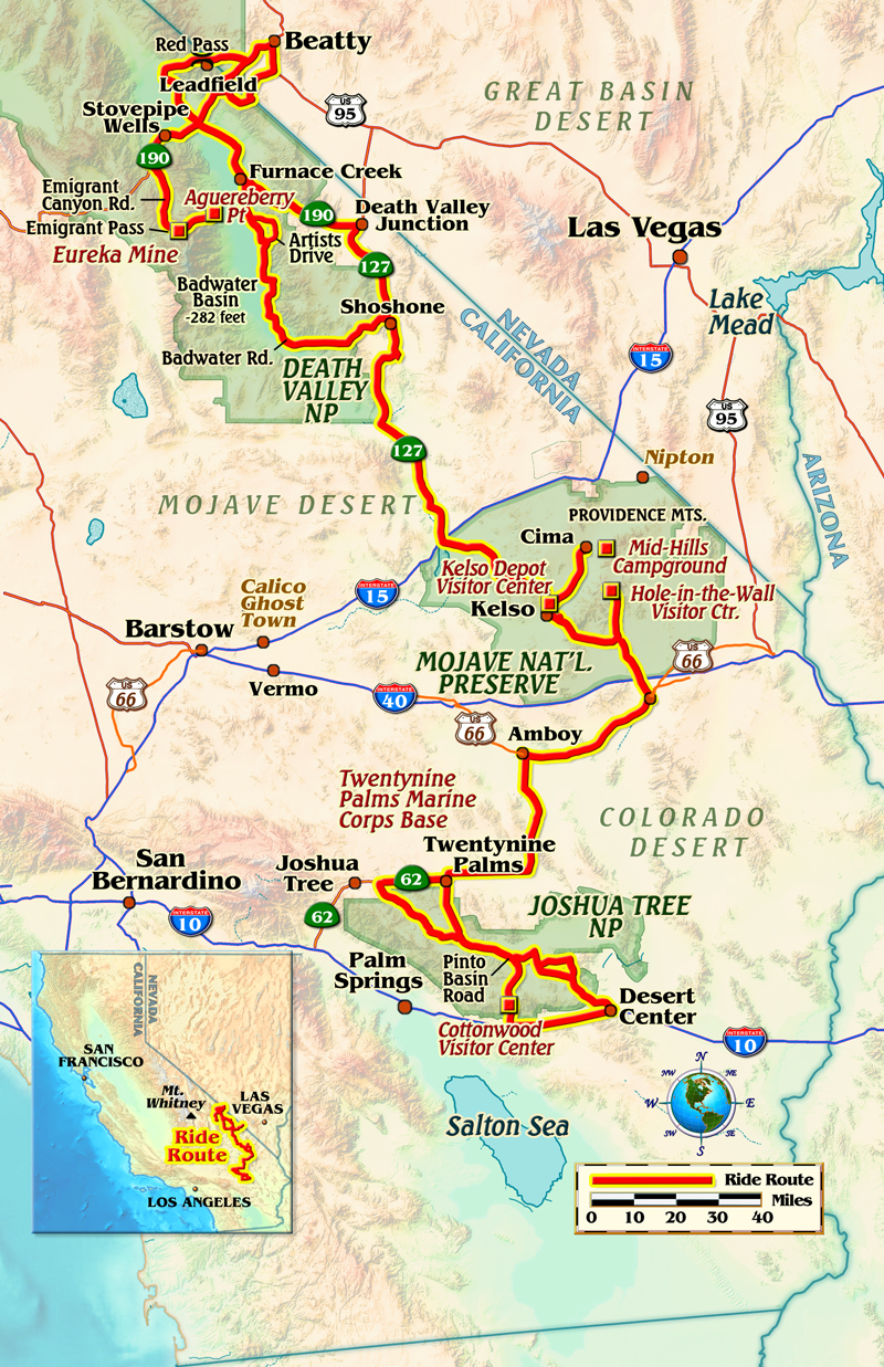
Straddling the Colorado and Mojave deserts, Joshua Tree National Park is full of its namesake trees, various species of cacti, rock formations and unpaved roads that take you off the beaten path. Photos by the author.
Rolling through Death Valley National Park, I have an eerie feeling that I am being watched. Passing a road sign indicating that I am below sea level, a glance at the GPS confirms it–150 feet below sea level, in fact! But who is spying on me? Pulling over to contemplate the situation and grab a few pictures of the amazing landscape, I have goosebumps, but it isn’t from the brisk February morning air since I’m wearing heated gear.
I am traveling alone and the uneasy feelings will haunt me throughout my three-week journey. As a birthday present to myself, I’ve hauled my 2018 Yamaha XT250 from Missouri to escape the crummy winter weather and research three desert parks–Death Valley National Park, Joshua Tree National Park and Mojave National Preserve.
A map of the route taken, by Bill Tipton/compartmaps.com.
It’s not my first time here. In the 1960s, my father was stationed at Travis AFB here in California. He always had a scooter or a motorcycle and I was the kid who always darted outside at the sound of the engine. Dad and I loved exploring on two wheels, and now a mental image of him riding a Cushman and wearing an Air Force flight suit is coming into focus.
In his senior years he enjoyed sitting on the pillion of my Honda Gold Wings, reminiscing about our adventures. Now it’s me in my senior years, the Gold Wings are gone, and I’m finding that motorcycle adventures can be just as much fun on a 250 as they are on an 1800!
Aguereberry Point, perched at 6,433 feet in Death Valley’s Panamint Range, provides an exceptional view of Badwater Basin, the lowest point in North America.
Downshifting now for the upcoming turn onto Emigrant Canyon Road, I negotiate potholes, rocks, sand and dirt as the road ascends past Eureka Mine toward my destination today: the 6,433-foot overlook at Aguereberry Point. Below is Badwater Basin, the lowest point in North America at 282 feet below sea level. Mount Whitney, the highest point in the contiguous 48 United States, resides 85 miles to the northwest.
To get here I’ve skirted decrepit mines and settlements scattered throughout the park. Encompassing 3.4 million acres, Death Valley is the largest U.S. national park outside Alaska, with nearly 1,000 miles of roads providing access to spectacular remote locations–provided you are on a street-licensed machine. A dual-sport is perfect, and an adventure bike can handle most of the unpaved byways.
This park features rugged mountains rising as much as 11,000 feet, deep and winding canyons, rolling sand dunes and spring-fed oases, some of which are accessible on street bikes. But to see today’s sights you’ll need long-travel suspension, good ground clearance, prior off-road experience and the ability to pick up your bike by yourself if you choose to travel alone. There were days exploring these parks that I didn’t see another human being until I returned to pavement.
Due to harsh conditions, with extreme temperatures and months of no rainfall followed by flash floods, only the hardiest plants and animals can survive in the desert.
I chose February for this trip because summer daytime temperatures often exceed 120 degrees and nights remain hot, with lows in the 90s. This winter morning is typical–bright sun, a light breeze and afternoon highs in the 70s in the basin and in the 40s and 50s in the mountains.
One morning I take the fun-to-ride paved and winding Badwater Road south from my campground at Furnace Creek to Shoshone, where I plan to refuel and have lunch. I’ve clocked my fuel-injected XT250 at 70 mph on a GPS, but today I’m limited by the hills and blind curves. It’s 150 miles round trip to Shoshone–doable with the XT’s 2.6-gallon fuel tank and estimated 76 mpg fuel economy, but fuel outside the park is nearly $2 a gallon cheaper! I fill up in Shoshone, which allows exploring several of the attractions along the way, such as the newly paved and unforgettable Artists Drive. The curvy, one-way drive through mountains and canyons displays a colorful palate of ancient claystone. There are several parking areas for water breaks and photography.
Although unpaved backcountry roads provide more adventure and solitude, the well-maintained paved roads through the desert parks offer easy access and beautiful scenery.
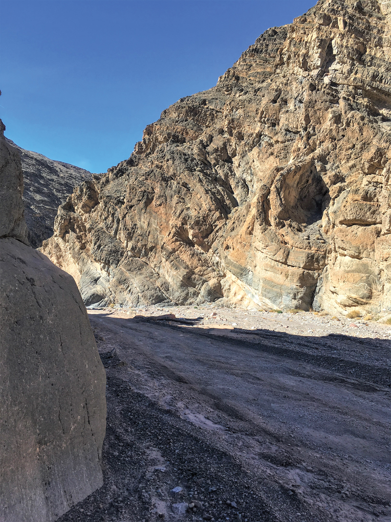
My day on Badwater Road and Artists Drive was a highlight of my Death Valley adventure, but the best was yet to come! Having an off-road vehicle allows access to Titus Canyon, a rough, rocky road that is steep and narrow and often closed due to snow, mud or washouts. The one-way entrance is in Nevada and the exit is in California. Twenty-seven miles long, the canyon is infrequently patrolled and summer travel is not advised. Fuel, food and water are available in Beatty, Nevada, six miles from the canyon entrance. The trip to Beatty from my campsite at Furnace Creek was 40 miles. Careful fuel planning is essential, but you’ll be treated to an adventure of steep climbs and descents, colorful rock deposits and fossil beds 30 to 35 million years old. The fossilized skull of a huge, rhino-like Titanothere was found here in 1933.
The highest point on the road, Red Pass (5,250 feet), affords a grand view and a great place for a break. Next up is the ghost town of Leadfield, which “boomed” for less than a year in 1926-27 because the lead deposits bottomed out quickly. All that is left today are a few shacks and a number of mines.
Accessible via Titus Canyon Road, a winding one-way dirt road that climbs over 5,250-foot Red Pass in Death Valley National Park, Leadfield was a mining town that boomed and busted in 1926-27.
The final 1.5 miles of the canyon are narrow; the walls squeeze down to less than 20 feet apart in some places. As the road enters the narrows it descends into the roughest part of the ride, but it’s no big deal for the XT with its remarkable 11 inches of ground clearance and 9/7 inches of front/rear suspension travel. With a 21-inch spoked front wheel, 51 degrees of maximum turning angle and a seat roughly 31 inches above the ground, the canyon is a walk in the park. From there I enter an area of shadow and echoes that make my 250 sound like a 650! Moments later I emerge from the canyon into dazzling sunlight and the conclusion of part one of my adventure.
The final 1.5 miles of Titus Canyon is narrow, squeezing down to as little as 20 feet across, making it vulnerable to flash floods.Navigating loose gravel in the wash is easy on a light dual-sport like the XT250.
The historic town of Kelso, plopped down in the center of Mojave National Preserve, is some 100 miles south of Death Valley, and connected to the larger park not just by geography, but also captivating railroad history. The fabled Harmony Borax Works in Death Valley desperately needed a rail line to replace the slow and treacherous twenty-mule team route. But one steam locomotive was not capable of hauling heavy loads over the steep two-percent grade at Cima Summit, which meant “helper engines” would need to be stationed nearby to assist locomotives up the 2,078-foot ascent. And, steam locomotives needed water.
There was a reliable water source from a spring in the Providence Mountains, so Siding #16, later renamed Kelso, became the site of the helper engine station that made the route to Los Angeles a reality. In 1924 Siding #16 was refurbished into the handsome Spanish Mission Revival-style depot that stands today as the preserve’s visitor center. If you are a train history buff, plan on spending a couple of hours absorbing the enchanting museum/historic monument.
In the late 1800s, twenty-mule teams transported borax from Death Valley mines to the nearest railroad spur, 165 miles away.
There’s other history as well, including Route 66, which was officially established in 1926 and ran parallel to what is now Interstate 40, which forms the southern boundary of the Mojave Preserve. The Mojave Desert spreads through portions of California and Nevada and very small areas in Arizona and Utah. It encompasses nearly 50,000 square miles and contains most of Joshua Tree and Death Valley national parks.
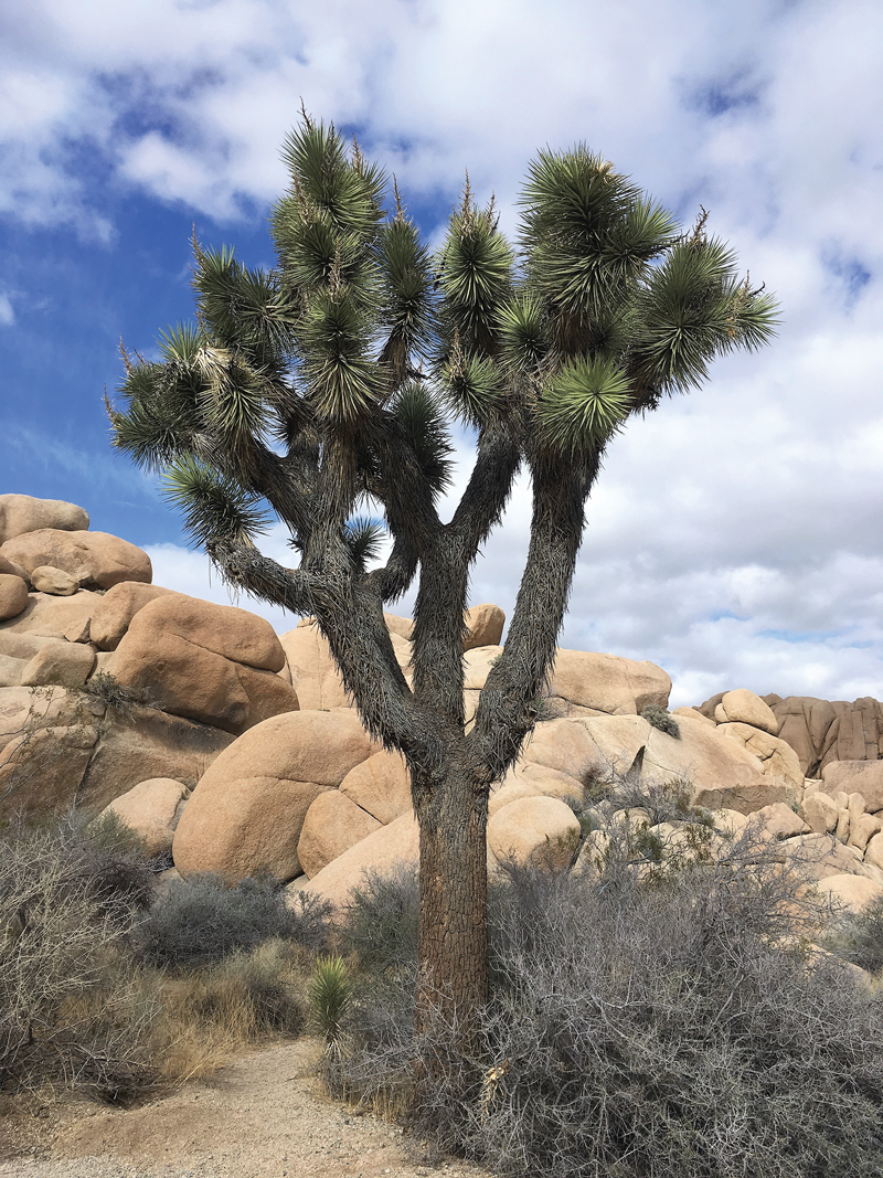
A member of the agave family, Joshua trees (Yucca brevifolia) thrive within a narrow range of elevation in certain desert regions of the Southwest.
There are also two famous ghost towns: Calico, with several shops and attractions, and Nipton, on the northern entrance to the Preserve, a restored ghost town founded in 1885. Both are reachable on street bikes. Other ghost towns, mining camps, petroglyphs and similar attractions require gravel road travel, including the lovely and quiet Mid Hills Campground. The main campground, Hole-in-the-Wall, is on a paved road. Neither campground has water when I arrive, but I have plenty to last four nights while enjoying the stunning sunsets, sunrises and astonishing starry nights.
Camping is a great way to experience to beauty of the desert parks, where you can enjoy the color and serenity of dawn and dusk.
Eighty miles to the south brings me to Joshua Tree, which is decidedly more developed and touristy than Mojave and more crowded than Death Valley. But then it’s closer to Los Angeles and has fewer roads for visitors to spread out on. It also has magnificent scenery, interesting geology and the famous Joshua trees, which aren’t trees at all but rather yucca plants. On my first day in the park the XT and I tour from the north entrance at Twentynine Palms around to the west entrance at the busy town of Joshua Tree, then follow State Route 62 back to our starting point, a trip of 50 miles, more if you explore the many gravel side roads.
Covering 1,235 square miles, Joshua Tree National Park is slightly larger than Rhode Island.
The next day we explore lovely, curvy, paved Pinto Basin Road down to Cottonwood Visitor Center, near Interstate 10. The dramatic, ever-changing geology is not to be missed. On the way back to my campsite I muse how far XTs have come since I bought my first one in the 1980s–a kickstart, carbureted 350. In that same decade I also discovered Edward Abbey, lover of wilderness, park ranger and author of “Desert Solitaire,” who once sarcastically called his beloved desert a “red wasteland.” Could it be his watchful eyes that I’ve been sensing these past few weeks?
Lower Fox Creek School at the Tallgrass Prairie National Preserve. Accessible by a decent gravel road and worth checking out. Photos by the author.
A couple of years ago I did an east-to-west and back ride across north central Kansas. One of the highlights was the Flint Hills, a narrow ecoregion famous for flint deposits just below the ground’s surface and rich grasslands above. It bridges eastern farmlands with the drier western plains and stretches from just south of the Nebraska line into Oklahoma. Early pioneers called it “the Great American Desert.” Rural Kansas at its finest, I spent a few days prowling its highways getting to know it better.
Many people believe Kansas is flat as a board and boring. This stretch of K-99 contradicts that perception.
I kicked off the ride at the Evel Knievel Museum in Topeka (read the story here), then pointed my trusty V-Strom west on K-4, the Native Stone Scenic Byway. An 1867 Kansas law closed the open range and offered settlers 40 cents per rod to build stone fences with the abundant material. Some of the work is original, some is undergoing restoration. The byway’s 48 miles includes sections of K-99 as well and ranks among the curviest I’ve ridden in Kansas. I took it to Manhattan, where I visited the Flint Hills Discovery Center, a good resource.
Map of the route taken, by Bill Tipton/compartmaps.com.
North of town, I bedded down at Tuttle Creek Cove Park on Tuttle Creek Lake, one of several reservoirs built and managed by the Army Corps of Engineers. The projects are multi-faceted, providing flood control, drinking water and recreation. In contrast to my previous ride, the Flint Hills were markedly drier and it showed in the lakes and rivers. Thankfully, the region was spared the wildfire havoc that occurred farther west the previous summer.
Structures like this abound in Kansas. If you look closely, this one has some modern windows. A restoration in progress, perhaps?
K-99 was to be my primary north/south route on the eastern leg, but construction at Tuttle Dam altered the plan. U.S. Route 24 to K-16 put me back on track to U.S. Route 36, which represents the region’s northern boundary. A sign along the highway invited me to “Experience the Flint Hills.” A group of inquisitive cattle were the welcoming committee. I wonder if their collective memory associates riders on motorcycles with cowboys on horses, as they often dutifully line up as if awaiting orders. In addition to status as a former Pony Express stop, Marysville is known as the Black Squirrel City, which explains the statues honoring the little rodents. I was told that hitting one could result in a $500 fine. Not worth dropping the bike over, in my opinion. While in town, I recommend the Wagon Wheel Cafe. Good food and reasonable prices, my kind of place.
A friend who knows cattle opined that their interest in me and my bike likely stemmed from the hope I was delivering something to eat.
U.S. Route 77 is the main north/south route through the western Flint Hills. Miles of the road travel through the 100,000-plus-acre Fort Riley installation. Riding down that lonesome highway it’s easy to see why the sparsely populated region is ideal for military maneuvers. Like most Kansas byways, U.S. 77’s gently rolling pavement is of consistently of good quality–no bike-swallowing potholes like back home in Indiana. But for me, the biggest draw is that the road seems to melt into the horizon, as if you could roll on forever.
I inspect equipment at a steel mill for my day job. This rig along U.S. 77 had a loose drive belt–the squealing immediately caught my attention.
Along with cattle, fire is the main shaper of the Flint Hills ecosystem. Controlled burns each spring pare down weeds and invasive species such as juniper trees transplanted by the settlers. The saplings choke out the native grasses. A ranger at the Tallgrass Prairie National Preserve told me that signs of a fire I saw were doubtless accidental, as no landowner would burn in August, particularly one this dry.
An apparently abandoned antique shop in Cottonwood Falls. The mini-bike looks a lot like one I used to have. I’d love to see what other treasures are inside.
Nightfall found me at another Corps of Engineers project, the 8,000-acre El Dorado Lake. The earthen dam was typical of their practice and contains many acre-feet of water. I marveled at the elegant efficiency of these unassuming structures. That’s probably an oversimplification, but in any case, the Corps knows what they’re doing and run nice campgrounds.
The Flint Hills Scenic Byway, just north of Cassoday. One of the hidden gems of the Sunflower State and a great motorcycle road.
Like Topeka, Augusta lies near the edge of the Flint Hills. Since my route included a jog onto U.S. Route 400, I couldn’t pass up the Twisted Oz Motorcycle Museum. While riding into town, pay attention to the north side of the road as Sculpture Hill comes into view, an assemblage of more than 50 steel figures depicting rural Kansas life. Unfortunately, metal artist Frank Jensen’s creation is not open to the public.
Frank Jensen’s larger-than-life rendition of the nemesis of the plains: the grasshopper. Hundreds of its smaller siblings bounced off my Aerostich Combat Touring boots.Jensen’s attention to detail is apparent in this piece. I can only imagine the hours he toiled with torch and stinger creating this beauty.
Back on U.S.77, I stopped for a break at the Solid Rock Cafe in Rock, population 191. As I finished my strawberry pie and coffee, a rider wearing a Ducati jacket and carrying an Arai helmet stepped inside. I knew I had to talk to this guy. I learned he was from Wichita, out for a birthday cruise on his recently-acquired 2008 Ducati 1098R, one of 600 produced and, coincidently, about to turn 600 miles on the odometer.
A chopped coupe with small-block Chevy and three deuces, backed up by a ’55 Chevy sedan. “New old” cars at the Strong City Standard station.
Arkansas City, known locally as Ark City, is the last Flint Hills town in Kansas. There I swung east on U.S. Route 166, bypassed Sedan and picked up K-99 once again. Black clouds inspired me to find a hotel in Eureka, where I also had a fine catfish dinner at Copper Kettle. Aside from keeping dry, the main benefit of hoteling it is hitting the road earlier. Heading west on U.S. Route 54 before dawn, I was treated to a blazing sun breaking open the wide horizon in the Strom’s rearview mirrors. Quite a sight.
Wind power is nothing new in Kansas and has been employed for more than a century. This well-maintained example is on K-177.
My loop’s last leg was K-177, 47 miles of which is designated the Flint Hills Scenic Byway. Though not as curve-filled as Native Stone, it still has enough sweepers and rolling hills to be entertaining. But more importantly, I appreciate the empty feeling it inspires. One stretch could well be the Great American Desert the pioneers spoke of. Aside from the pavement and some fence lines, there’s nothing but grass.
An overlook on the Flint Hills Scenic Byway. I was a bit disappointed as the grass was overgrown compared to the last time I stopped here.
Continuing north, I visited Cottonwood Falls, the Chase County seat which boasts of the oldest courthouse in Kansas. West of town, I explored Chase State Fishing Lake. The gravel access road was well maintained, but as with other side trips I was glad I was running 80/20 dual-sport tires on the Strom. The Shinko 705s noticeably improve the bike’s gravel road manners. On paved corners, the peg feelers grind before they run out of grip. It’s good all-around rubber.
The Chase County Courthouse served as William Least Heat-Moon’s research headquarters while writing “PrairyErth,” a history of the Flint Hills. It is a striking structure.
On my last visit to Strong City I arrived just as the Tallgrass Prairie National Preserve was closing, so this time I made a point to get there in time to tour some of the former Spring Hill Ranch, including the limestone mansion and barn that are incorporated in the park’s nearly 11,000 acres. A now-thriving bison herd with 99-percent purity was reintroduced in 2009 and numbers 110, with 23 calves born this spring.
I’d hoped to solve the mystery of the Strong City Standard station cars from my last Kansas article, but no such luck. Next time, I’ll inquire around town about them.
During the westward migration, Council Grove was the last place to buy supplies before embarking on wilder portions of the Santa Fe Trail. An ironic place to conclude my Flint Hills experience, but all rides must come to an end. After lunch at the Hays House, I gassed up and headed the opposite direction of those hardy pioneers, east on U.S. Route 56. I’ll doubtless be back.
My last visit to the Hays House was also during steamy summer weather. But this time the heat hadn’t waylaid me. I was able to enjoy the excellent food.The Cassoday Country Store offers breakfast and lunch. The lot might be full of bikes, or pickups pulling horse trailers. Or only a lone rider like myself. All are welcome.
Mid-morning sun warms Kettle Cove at low tide. Photos by the author.
When New Englanders talk of “The Cape,” typically they mean Cape Cod, the flexing arm of Massachusetts that reaches from the South Shore into the Atlantic. But there’s another peninsula jutting into the Atlantic off the North Shore: Cape Ann. Here you’ll find “America’s Oldest Seaport,” scenic beaches, fresh seafood, stunning vistas and narrow, winding roads connecting it all.
A map of the route taken, by Bill Tipton/compartmaps.com.
The ride begins on State Route 127 in Beverly. You pass the oceanfront campus of Endicott College, where my daughter and money are both going. Each July, Endicott’s ocean-front Misselwood Cottage hosts a Concours d’Elegance, an event that may help you source a vintage Rolls-Royce or Duesenberg for the carriage house at your seaside estate.
Homes built on rocks are common on Cape Ann’s coastline. As my wife likes to say, “That would do.”
As Route 127 winds through Prides Crossing, the region’s rocky geography becomes apparent. Homes are often made with stone, surrounded by stonewalls or built on rock outcroppings. The Singing Beach in Manchester-by-the-Sea presents a fun phenomenon: dry sand that creaks as you walk on it.
In Manchester-by-the-Sea, the lobster boat Diana Lee rests on stands in a yard. After a long Cape Ann winter, it should be back on the water soon.
In Kettle Cove Village, turn right onto Ocean Street to hug the shoreline along White Beach and then Black Beach before rejoining 127. In Magnolia, a right off 127 onto Shore Road takes you past some of Cape Ann’s grandest homes and stunning ocean vistas. The views certainly beat the road. I encountered one section with potholes that could swallow a Buick. “I like the bumps,” a cheerful old woman in front of her home told me. “It keeps people from passing through.” Guess I missed that memo, ma’am.
The elderly woman whose house commands this view came outside. I said, “Sure is beautiful here.” She replied, “The only way I’ll ever leave is in a pine box.”
Beyond those bumps I returned to 127 and found Hammond Castle, where a museum displays inventions of John Hays Hammond, Jr. (1888-1965). Hammond held more than 400 patents, many related to radio remote control. You might thank him next time you change channels from the couch.
Gloucester (natives say “GLOSS-tuh”) calls itself “America’s Oldest Seaport.” Settled by English immigrants in 1623, Gloucester rises above a natural harbor. For nearly four centuries, fishing has been the community’s lifeblood. It’s so engrained in local culture, Gloucester’s high school sports teams are called the Fishermen. An easy self-guided walk (less than 2 miles) takes you through Gloucester’s working waterfront and historic downtown. There’s way more than you can glimpse–or eat–riding by.
Stalwartly facing Western Harbor are two memorials to remind passersby that fishing at sea is a dangerous occupation. East of the drawbridge over Blynman Canal, the Gloucester Fisherman’s Memorial honors 5,368 Gloucester fishermen who have perished at sea since 1623 (officials now peg the total number lost at more than 10,000). The memorial includes “The Man At The Wheel,” a statue commissioned for Gloucester’s 300th anniversary in 1923. The inscription, THEY THAT GO DOWN TO THE SEA IN SHIPS, is borrowed from Psalm 107:23. West of the drawbridge is the Fishermen’s Wives Memorial, erected in 2001 to honor the faith, diligence and fortitude of the wives and families of fishermen.
On Gloucester’s waterfront, the Fisherman’s Memorial honors THEY THAT GO DOWN TO THE SEA IN SHIPS.
Beyond the Cape Ann Whale Watch terminal, turn right onto Route 127A for views of the harbor and also Boston on a clear day, especially from Niles Beach. At Good Harbor Beach there’s a large, flat parking area, a rarity in these parts. During the off-season (October through April), dogs are welcome here on even-numbered days. Today is April 16 and temperatures have spiked into the 80s. Good Harbor Beach is dog utopia and I make several new friends.
A warm, even-numbered, off-season day spells “dog central” at Good Harbor Beach.Boo-Boo, a Bernese Mountain Dog/Golden Retriever hybrid, knows the best time to roll in the sand is when you’re wet.
Next up the coast is aptly named Rockport, for years a major source of granite for the eastern United States. Also historically an artists’ colony, Rockport has a different vibe than Gloucester. The historic business lane down Bearskin Neck, with its galleries, shops and restaurants, reminded me of Harry Potter’s Diagon Alley. Walk onto the breakwater for views of Rockport Harbor. After 127A merges back into 127, drop down to Granite Pier for views of Rockport’s Back Harbor.
If you haven’t needed lunch until now, just past Halibut Point State Park you’ll find the Lobster Pool. This old school, side-of-the-road, on-the-water eatery served me a sumptuous sandwich of yellowfin tuna–seasoned, seared and served rare, as nature intended (drool, drool). The view out back made it taste even better. Manhandling my bike into the one meager parking space that was available proved worth the effort.
The Lobster Pool’s yellowfin is seasoned, seared and served rare, as nature intended.
When 127 ends at the rotary, hop onto Route 128, cross the Annisquam River, and take the second exit to enjoy Concord Street, which cuts and curves through Cape Ann’s interior. The landscape is worlds away from the seacoast route thus far. When Concord Street merges with Route 133, continue into Essex, where more fresh seafood restaurants await. You’ll also find the Essex Shipbuilding Museum and the Essex Riverwalk, both worth a visit.
If you still haven’t eaten–or if you’re ready for more–stop at the Clam Box, an Ipswich institution for more than 80 years. Its tall, angled walls resemble a box of fried clams…hard to miss. Regulars suggest the fried whole-belly clams. A short ways farther, the route concludes at Winthrop Elementary School. Why here? I like the giant dog statue out front.
College Hall, an English Tudor-style mansion, highlights Cape Ann’s ubiquitous stone. Built in 1916 as a summer residence, today it houses the office of the president of Endicott College.
While this ride is just 54 miles, with frequent stops it can take all day. If you ride more and stop less, turn around at the end and reverse course for a different perspective. My advice is to ride here during the off-season. A warm day in April, May, September or October will have less traffic and fewer pedestrians that often clog these narrow oceanside streets in summer.
Riding in Montana is big: big skies, big trees, big rivers and big fun. Photos by the author.
It’s with a nod to the late, great music show host Lawrence Welk that I start this ride spanning a couple of Montana’s scenic blue highways. The bandleader’s famously accented musical lead-in is doubly relevant for this trek. First, this ride will begin and end with music. Second, it will encompass rolling on Montana’s historic Highways 1 and 2. So, without further ado, “Ah one, an’ ah two….”
Map of the route taken, by Bill Tipton/compartmaps.com.
Rockin’ the Rivers and Rollin’ on Highway 2
While it is most certainly true that it’s “about the ride not the destination,” having something entertaining to do before and after a ride adds spice to the adventure. With that in mind, my trek starts at the Rockin’ the Rivers Music Festival near Three Forks, Montana. It is not an accident that I found this event in my ride planning as it sits directly on the first of the routes that attracted me to the area. So as I sit listening to the classic rock of the Grass Roots and then Tommy James and the Shondells, my mind wanders to Montana State Highway 2.
The Grass Roots echo in the grasslands at the Rockin’ the Rivers Music Festival.
As I leave the festival, my ride on Highway 2 leads me almost immediately to the entrance of the Lewis and Clark Caverns State Park. While I decide not to do any spelunking, I stop long enough to read about the caverns and the fact that the Lewis and Clark expedition camped very close to the cave.
Rolling out of the park, the riding fun begins. The 20-mile stretch of Highway 2 that leads to my night’s lodging in Whitehall, Montana, is a great series of curves that follows the Little Pipestone Creek through an impressive river canyon. It is a nice precursor to what I will experience the rest of this ride.
This ride is dotted with historical sites, many of which document the Lewis and Clark expedition.
After a night’s sleep, I gas up in Whitehall and head northwest on the remainder of Highway 2. I roll past farms and ranches through big, sweeping curves. As I continue north, the grasslands morph into high chaparral. The road tightens into some entertaining hairpins as I gain elevation into a pine forested stretch. This is clearly great three-season motorcycle country.
The motorcycles in Montana are as diverse as the music.
Ultimately, this pine forest gives way to rich grasslands as I approach the historic mining town of Butte. Before grabbing lunch in a local diner, I ride through Butte’s well-preserved historic district. Amazingly, there are more than 10,000 miles of abandoned mine shafts and tunnels beneath the city. The wealth attained in those mines earned Butte the moniker “The Richest Hill on Earth.”
Rivers like the Little Blackfoot make the area around Missoula a fly fishing paradise.
Carving Highway 1 to a Jam in Missoula
A short stretch on Interstate 90 after Butte leads me to the exit for Montana State Highway 1. Signs tell me that Highway 1 is also known as the Pintler Veterans Memorial Scenic Highway and it certainly lives up to that “scenic” designation.
The first thing that catches my eye as I head west on the highway is a huge smokestack in the distance. It turns out that smelter stack is the most notable landmark in the town of Anaconda. It also turns out that the town’s name is prophetic. After leaving Anaconda, the road begins to coil into a serpentine motorcycle playground.
The road west of Anaconda clings resolutely to spectacular crimson canyon walls.
As I climb into the Anaconda-Pintler Mountain Range on Highway 1, I stop at several interesting historic sites. Montana does a great job of providing well-written and informative signage for its historic markers. Just as Lewis and Clark’s exploration is well-documented on the route, significant mining windfalls are also highlighted.
The author does a bit of map study beside yet another interesting historical marker.
I stop beside the deep blue waters of Silver and Georgetown lakes, which spell the approximate midpoint of this ride on the scenic route. After the lakes, the road coils again as it passes through pines, grasslands and crimson canyons. It’s a very entertaining ride indeed, and the number of motorcycles I meet on the road indicates it is not a secret to riders.
Blue waters and blue sky converge at Montana’s high-mountain Silver Lake.
The Pintler Veterans Memorial Scenic Highway ends at Interstate 90. However, I have found that it can pay off in spades to travel frontage roads rather than the nearby interstate. The long frontage road on this stretch of I-90 to Missoula is just such a find. The beautiful tree-lined Clark Fork River separates the interstate from the frontage road, making it seem worlds away. Like so many of the rivers in the area, the Clark Fork makes me think of Norman Maclean’s Montana-set literary masterpiece, “A River Runs Through It.”
This frontage road is a nice alternative to riding on the interstate south of Missoula.
When the fun of the I-90 frontage roads ends, there is just a short stretch of the interstate that leads to Missoula. Like Butte, Missoula is a town worth an extended visit. The historic city has a bustling charm that is enhanced by the vibrancy infused by the University of Montana.
Pearl Jam rocks the beautiful University of Montana football stadium in Missoula.
As I sit in the beautiful Montana Grizzly Stadium listening to Pearl Jam and watching the sun set on the rolling hills just past the stage, I can’t help but reflect on a great ride. To steal a few song titles from the band, the “Even Flow” of the ride certainly made me feel “Alive.” Or, as Mr. Welk might say, this Montana tour was “wunnerful, wunnerful.”
On the Blue Ridge Parkway at milepost 101, the Ducati makes me look better than in real life. In the background is the Quarry Overlook. This dolomite quarry was started in 1916–twenty years before the Parkway. Photos by the author.
Virginia’s Blue Ridge Mountains in autumn are a place of unique beauty not to be missed, especially from the open cockpit of a motorcycle. From my home in the northern tip of the state, the Virginia border runs diagonally southwest for more than 300 miles, parallel to the ridges and valleys of the mountains.
In the southwest corner are my two ride objectives: the Back of the Dragon, a 32-mile run of elbowing blacktop crossing three mountain ridges, and The Crooked Road, a collection of live music and historical venues along scenic motorcycle roads showcasing the regional specialty: bluegrass music. I also plan to make use of the scenic Blue Ridge Parkway, but only when my ambitious schedule will let me travel at the Parkway’s reduced speed limit of 45 mph.
Cars first rambled through this stone tunnel on the Blue Ridge Parkway south of Montebello in the 1930s. I’m sure it didn’t take long for the first motorcycle to follow!
It takes a day to get to my start point of Wytheville, but not without a midday detour along the Blue Ridge Parkway from near Montebello to Buchanan. I share the view at numerous overlooks with other riders, then enjoy lunch on the shore of Abbott Lake beneath the Peaks of Otter. There’s no wondering why the Parkway consistently rates among the top five motorcycle roads in the United States. A rider’s dream, the curvy ridge-top road runs through stone-arched tunnels and next to lakes, campgrounds and lodges–all completely devoid of traffic lights, stop signs and large trucks. Free for public use, the Parkway is open all year except in icy conditions.
Next morning I wake up in Wytheville to a steady rain lingering longer than forecast and wind gusts flexing the glass of the hotel window. I decide to motor circuitously and enter the Back of the Dragon at the north point to allow time for the rain to move out. I take U.S. Route 52 and enjoy a satisfying and twisty climb to Big Walker Lookout, elevation 3,405 feet. Here I find the Big Walker General Store and take a short break to enjoy the terrific views under overcast skies.
A group of riders with camping gear rolls along the Blue Ridge Parkway north of the Peaks of Otter, no doubt heading to one of the Parkway’s many campgrounds.
From there U.S. 52 curves downhill, then runs over rolling terrain alongside Interstate 77 for 20 or so miles—then suddenly joins the interstate and punches through a mile of mountain rock at the East River Mountain Tunnel. I then head west on U.S. Route 460 to Tazewell and turn onto State Route 16–the Back’s north entry point. Thankfully, the rain has stopped and the road is mostly dry.
There are neat, steady curves across the first ridge before dropping more than a thousand feet for a two-mile cruise through a gorgeous, Shire-like valley. The road then winds up the face of the second ridge and slices behind towers of leafy kudzu. Then come mile upon mile of pleasing twists along the second ridge before switchbacking downhill into the second valley, a nice break before the final 1,500-foot climb.
My growling and nimble Ducati Multistrada eats up the twisty climb and we loop through bursting autumn colors that surround rocky crests. The road surface is mostly excellent, though I did encounter a little gravel in spots.
U.S. Route 52 north of Wytheville takes one last dip to the left before twisting its way to Big Walker Lookout. The excellent road surface seen here is what I encountered on every mountain road on my trip.
State Route 16 continues south through Marion and later connects with U.S. Route 58–I’m now officially on The Crooked Road. Designated by the state of Virginia in 2004, The Crooked Road uses U.S. 58 as a central conduit but includes connected roads leading to festivals, museums and live music sessions, all associated with the heritage of bluegrass and country music.
I’m committed to being at the Floyd Country Store for the Friday Nite Jamboree, so I shortcut there on U.S. Route 221. Time permitting, I recommend an alternate route using the Parkway to Floyd and stopping by the Blue Ridge Music Center near Galax for the live music each afternoon.
To get a seat at the Floyd Country Store’s Friday Nite Jamboree you have to get by Barb and Beverly at the ticket counter–I think the five spot is a bargain just for their smiles and friendly company.
The Floyd Country Store is a crown jewel of The Crooked Road. A modest cover charge of $5 gets me in the door. After an initial set of bluegrass gospel, folks are clearing away folding chairs and dancing to the fast-paced syncopation of Katie & The Bubbatones. Many “flatlanders” like myself are simply tapping our feet, but it’s clear that this lively music is still an important way for local folks to unwind after a busy week. On my way out I bag a pastry at the store’s bakery to have with next morning’s coffee.
The sun rises to a chilly but crystal clear morning as I depart Floyd’s cozy Pine Tavern Lodge, a clean and updated hideaway that has continuously served travelers since 1927. A peaceful winding ride on State Routes 8 and 40 takes me through elevated meadows and rolling farms, across small wooded creeks and finally to the Blue Ridge Folklife Festival in Ferrum. You’ll find such festivals along The Crooked Road almost any weekend from June through October.
At the Blue Ridge Folklife Festival, metal meets metal and sparks shoot forth when Billy Phelps brings the hammer down. Billy is a Master Blacksmith who has given live demonstrations at the Smithsonian in Washington, D.C.These experts fix the cap arm on a moonshine still. They taught me a lot–alcohol boils off at 172 degrees (a lower temperature than water) so the cap arm catches the alcohol steam for condensation into moonshine.An Amish group set up a donut operation that was nonstop busy. I ate the best donut that I have ever eaten–or will ever eat.
I decide I need a final cruise on the Parkway so I get there by U.S. 220. Once on the Parkway, two groups of motorcyclists are going my direction, and we leapfrog along the Parkway as we take turns stopping at different overlooks. I exit the Parkway for good on State Route 43 for the small town of Bedford, a place that possesses the tragic distinction of losing more residents per capita in the D-Day landings than any other American community. Bedford’s D-Day Memorial is a good, quiet place to reflect on how fortunate I am to be able to traverse through Virginia’s natural, cultural and historical sites before continuing on home–back to the flatlands.
Map of the route taken, by Bill Tipton/compartmaps.com.
Travel from Yuma to San Diego via historic U.S. Route 80 and the wood Plank Road, and you’ll see how unforgiving the desert can be. Photos by the author.
Picture a scene in which hearty travelers traverse barren and windswept sand dunes on roads of rough-hewn timbers. I am not talking about some prehistoric time nor am I forecasting a dystopian future. No, my friends, many still-living Americans could tell you of this strange and fascinating tale set in the American Southwest.
I recently happened upon a magazine article that mentioned a wood plank road that spanned the sand dunes linking the southernmost portions of California and Arizona. With my interest piqued, I dug deeper and discovered that the Old Plank Road was operational for more than a decade and was ultimately displaced by a paved portion of U.S. Route 80 in 1926.
Almost four decades later, U.S. 80 succumbed to Interstate 8. Now, the Plank Road is a fascinating, crumbling relic of the early 20th century; however, long portions of Historic U.S. 80 are still passable as an interesting alternative to I-8 from Yuma, Arizona, to San Diego, California.
That was enough for me. I dug deeper into the history of the Plank Road, researched Historic U.S. 80, charted my course and packed the bags on my BMW R 1200 GS. I was off to discover the Plank Road and ride as much of Historic U.S. Route 80 as possible from Yuma to San Diego.
The Ocean-to-Ocean Highway Bridge is the impressive opening act to the Yuma to San Diego trek. The bridge spans the Colorado River, and its 1915 completion date coincides with the Plank Road. Its name indicates its importance in the nationwide, transcontinental Ocean-to-Ocean Highway.
Yuma to El Centro – in Search of the Plank Road
The sun-drenched starting point of my ride was the history-rich city of Yuma, Arizona. Now snowbirds in massive RVs converge on the city in winter like their winged migratory counterparts. However, Yuma was once a centerpiece of the Old West, and has been a transportation hub of the Southwest for more than one hundred years.
I began my trek west at the Ocean-to-Ocean Highway Bridge, which spans the Colorado River in north Yuma. Now on the National Historical Register, the bridge was completed in 1915, which coincides with the early years of the Plank Road. The area directly surrounding the bridge is home to a cluster of historical sites. The Yuma Territorial Prison, which sits directly adjacent to the bridge, was an intriguing walk back into the rough-and-tumble Old West. The close-by Colorado River State Historic Park dates back to the late 19th century and preserves a small number of the Plank Road timbers in a display.
After riding over the Ocean-to-Ocean Highway Bridge, a quick left turn placed me immediately on Historic U.S. 80. The road took me by crumpling adobe structures, over the All-American Canal and through the sandy desert. Whereas nearby I-8 is smooth, wide and boring, Historic U.S. 80 is narrow, cracked, undulating and entertaining. It requires attention and a bit of slaloming to avoid jarring reminders that it is a historic route. The long suspension on the BMW was tailor-made for the unpredictable road conditions.
A ride on Historic U.S. 80 requires vigilance. Sand drifts, potholes and crumbling margins speak to its relegation to secondary status.
After this opening act of my Historic U.S. 80 tour, I rejoined I-8 for a bit. Portions of Historic U.S. 80 are relegated to spur status–they “spur” off of the interstate but terminate without rejoining the new route. One such spur is Grays Well Road.
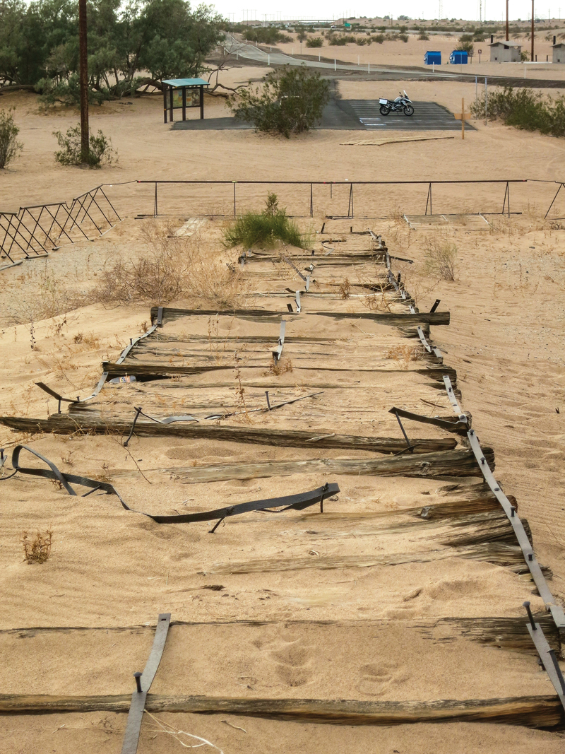
The Grays Well section of the original route is now a well-paved ingress into the Imperial Sand Dunes portion of the larger geological feature known as the Algodones Dunes. These dunes are what made the Plank Road necessary in the early 1900s. After enjoying a short, beautiful ride through shining sand hills, I came to the site that contains the longest and best-preserved portion of the Old Plank Road.
What I found was a stretch of the Old Plank Road that spans the equivalent of about five football fields in length. The road is protected from potential damage by off-road vehicles with metal, sand-worthy barriers, but visitors can touch and walk the Plank Road section. The road is intriguing. It has weathered and rusted into a heaving work of art.
One can almost hear the rhythmic thumping of Model T tires when visiting the protected section of the wood Plank Road. The vast majority of nearby interstate travelers have no idea that this historic relic even exists.
So why was the timber road ever built? Quite simply, it was commercially important to have a direct route here from the growing and thriving San Diego coastal area to the west. While asphalt and concrete road building techniques of the time worked reasonably well on the harder surfaces of the area directly east of the coast, the shifting sands of the Algodones Dunes posed a huge quandary for road builders.
San Diego businessman Ed Fletcher was the driving force that ultimately led to the construction of the Plank Road. That bumpy, ever-changing, maintenance-intensive endeavor continued as the transportation solution for crossing more than six miles of the dunes from 1915 through 1926.
I walked, touched and studied the Plank Road in solitude. Not a single soul even drove by in the substantial time I spent in the surreal dunes. When I finally pulled myself away, I took another short ride on the interstate before jumping back on Historic U.S. 80 toward the California towns of Holtville and El Centro. The long, straight stretch of the historic road gave me time to ruminate on the Plank Road and the challenges of early travelers.
Much of Historic U.S. 80 runs parallel with and in close proximity to the interstate, but it is worlds apart in terms of traffic and fun. There are remnants and ruins of structures that were left to languish in the desert heat when traffic was rerouted to the newer and faster interstate.
Historic U.S. 80 runs through the hearts of both Holtville and El Centro, as both were supremely important to the commerce and trade of the time. Either of these cities can serve as a gas and food stop on this route; I found a hotel in El Centro just off the Historic U.S. 80 route.
The Cleveland National Forest spans 460,000 acres of desert and chaparral.
Ocotillo to Laguna Junction – on the Winding Road
While fascinating and historically rich, the prior day’s ride was, for the most part, straight. Motorcyclists, by nature, love curves and that is what this next leg of my ride on Historic U.S. 80 had to offer.
After a breakfast of huevos rancheros in El Centro, I made my way to Ocotillo. After rolling through the town, named after a type of cactus, I rode a nicely curvy stretch of I-8 until I came to the exit for the Desert View Tower. The tall, eclectic stone structure, which dates back to the time of the Plank Road, sits on another Historic U.S. 80 spur west of the interstate.
After a short visit to the tower, I crossed the interstate to the south onto a long, intact loop of Historic U.S. 80. The road is instantly winding and remains coiled for miles of highly entertaining riding. The little desert oasis town of Jacumba Hot Springs is home to its namesake spring, a few colorful buildings and a clothing-optional resort. I am sure to everyone’s delight I opted to stay clothed and keep riding.
The GS is right at home with several brethren outside the Jacumba Spa Restaurant.
At a few points along the route, the tall international border “wall” could be seen to the south and there were sporadic signs warning that the region is subject to illegal drug trafficking. However, from the rolling perspective of a motorcycle saddle, there is a slow-paced calm to the area.
I rode through several small clusters of humanity and miles of unspoiled nature toward the Campo Indian Reservation and the Cleveland National Forest. The road conditions are variable and there are sections of concrete as well as reasonably maintained asphalt. However, from a pure riding perspective, I found this to be the most entertaining stretch of the route.
The Jacumba section just north of the U.S./Mexico border is the most curvy and entertaining of the ride.
Laguna Junction to the Beautiful Balboa Park
At Laguna Junction, Historic U.S. 80 runs north of the interstate for a while as it winds to the west. I passed through the small towns of Guatay and Descanso Junction, and the increased elevation of 4,000 feet brought with it a nice mix of oak and pine trees. Where Historic U.S. 80 melds back into I-8, I could see several now impassable portions of the old road in the mountains to my right.
From this point on through Alpine, El Cajon and La Mesa, Historic U.S. 80 flirts with and becomes the interstate and other roads intermittently. The ride in this stretch was much more frenetic and filled with traffic than the rest of the route, and rolled through historic commercial districts and residential communities as the ride became increasingly urban.
The entrance of the stunning Balboa Park is an impressive foreshadowing of the treasures within.
After several miles of this suburban jockeying, I rolled to the end of my tour as I entered the stunningly beautiful Balboa Park. The “Jewel of San Diego” spells the approximate end of the Historic U.S. 80, and a perfect end to the ride. The lush natural environment combined with fantastic museums and entertainment venues like the Old Globe Theater make Balboa one of the most delightful parks in the Southwest.
My final stop was the San Diego Automotive Museum in Balboa Park, which houses a nice collection of historic motorcycles alongside vintage and unique cars and trucks. Fittingly, the museum features a creative display dedicated to the Old Plank Road, which brings it to life and provides a fine overview of this significant part of transportation history.
The San Diego Automotive Museum in Balboa Park features a current exhibition that brings the Plank Road to life.Historic photos and staged exhibits in the museum show the wonders and challenges of crossing the Imperial Dunes.
Riding Considerations
Being a desert region, this ride is best made from fall to spring. The summer months are sweltering. Road conditions are extremely variable as there are sections of both asphalt and concrete. Potholes, sand and some broken tarmac should be expected. For a detailed series of route maps, visit americanroads.us/ushighways/ushighway80.html.