

Picture a scene in which hearty travelers traverse barren and windswept sand dunes on roads of rough-hewn timbers. I am not talking about some prehistoric time nor am I forecasting a dystopian future. No, my friends, many still-living Americans could tell you of this strange and fascinating tale set in the American Southwest.
I recently happened upon a magazine article that mentioned a wood plank road that spanned the sand dunes linking the southernmost portions of California and Arizona. With my interest piqued, I dug deeper and discovered that the Old Plank Road was operational for more than a decade and was ultimately displaced by a paved portion of U.S. Route 80 in 1926.
Almost four decades later, U.S. 80 succumbed to Interstate 8. Now, the Plank Road is a fascinating, crumbling relic of the early 20th century; however, long portions of Historic U.S. 80 are still passable as an interesting alternative to I-8 from Yuma, Arizona, to San Diego, California.
That was enough for me. I dug deeper into the history of the Plank Road, researched Historic U.S. 80, charted my course and packed the bags on my BMW R 1200 GS. I was off to discover the Plank Road and ride as much of Historic U.S. Route 80 as possible from Yuma to San Diego.

Yuma to El Centro – in Search of the Plank Road
The sun-drenched starting point of my ride was the history-rich city of Yuma, Arizona. Now snowbirds in massive RVs converge on the city in winter like their winged migratory counterparts. However, Yuma was once a centerpiece of the Old West, and has been a transportation hub of the Southwest for more than one hundred years.
I began my trek west at the Ocean-to-Ocean Highway Bridge, which spans the Colorado River in north Yuma. Now on the National Historical Register, the bridge was completed in 1915, which coincides with the early years of the Plank Road. The area directly surrounding the bridge is home to a cluster of historical sites. The Yuma Territorial Prison, which sits directly adjacent to the bridge, was an intriguing walk back into the rough-and-tumble Old West. The close-by Colorado River State Historic Park dates back to the late 19th century and preserves a small number of the Plank Road timbers in a display.
After riding over the Ocean-to-Ocean Highway Bridge, a quick left turn placed me immediately on Historic U.S. 80. The road took me by crumpling adobe structures, over the All-American Canal and through the sandy desert. Whereas nearby I-8 is smooth, wide and boring, Historic U.S. 80 is narrow, cracked, undulating and entertaining. It requires attention and a bit of slaloming to avoid jarring reminders that it is a historic route. The long suspension on the BMW was tailor-made for the unpredictable road conditions.

After this opening act of my Historic U.S. 80 tour, I rejoined I-8 for a bit. Portions of Historic U.S. 80 are relegated to spur status–they “spur” off of the interstate but terminate without rejoining the new route. One such spur is Grays Well Road.
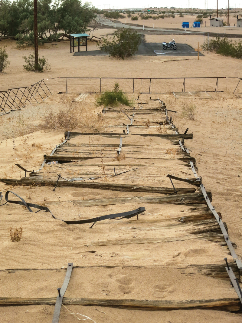
The Grays Well section of the original route is now a well-paved ingress into the Imperial Sand Dunes portion of the larger geological feature known as the Algodones Dunes. These dunes are what made the Plank Road necessary in the early 1900s. After enjoying a short, beautiful ride through shining sand hills, I came to the site that contains the longest and best-preserved portion of the Old Plank Road.
What I found was a stretch of the Old Plank Road that spans the equivalent of about five football fields in length. The road is protected from potential damage by off-road vehicles with metal, sand-worthy barriers, but visitors can touch and walk the Plank Road section. The road is intriguing. It has weathered and rusted into a heaving work of art.
So why was the timber road ever built? Quite simply, it was commercially important to have a direct route here from the growing and thriving San Diego coastal area to the west. While asphalt and concrete road building techniques of the time worked reasonably well on the harder surfaces of the area directly east of the coast, the shifting sands of the Algodones Dunes posed a huge quandary for road builders.
San Diego businessman Ed Fletcher was the driving force that ultimately led to the construction of the Plank Road. That bumpy, ever-changing, maintenance-intensive endeavor continued as the transportation solution for crossing more than six miles of the dunes from 1915 through 1926.
 I walked, touched and studied the Plank Road in solitude. Not a single soul even drove by in the substantial time I spent in the surreal dunes. When I finally pulled myself away, I took another short ride on the interstate before jumping back on Historic U.S. 80 toward the California towns of Holtville and El Centro. The long, straight stretch of the historic road gave me time to ruminate on the Plank Road and the challenges of early travelers.
Much of Historic U.S. 80 runs parallel with and in close proximity to the interstate, but it is worlds apart in terms of traffic and fun. There are remnants and ruins of structures that were left to languish in the desert heat when traffic was rerouted to the newer and faster interstate.
Historic U.S. 80 runs through the hearts of both Holtville and El Centro, as both were supremely important to the commerce and trade of the time. Either of these cities can serve as a gas and food stop on this route; I found a hotel in El Centro just off the Historic U.S. 80 route.

Ocotillo to Laguna Junction – on the Winding Road
While fascinating and historically rich, the prior day’s ride was, for the most part, straight. Motorcyclists, by nature, love curves and that is what this next leg of my ride on Historic U.S. 80 had to offer.
After a breakfast of huevos rancheros in El Centro, I made my way to Ocotillo. After rolling through the town, named after a type of cactus, I rode a nicely curvy stretch of I-8 until I came to the exit for the Desert View Tower. The tall, eclectic stone structure, which dates back to the time of the Plank Road, sits on another Historic U.S. 80 spur west of the interstate.
After a short visit to the tower, I crossed the interstate to the south onto a long, intact loop of Historic U.S. 80. The road is instantly winding and remains coiled for miles of highly entertaining riding. The little desert oasis town of Jacumba Hot Springs is home to its namesake spring, a few colorful buildings and a clothing-optional resort. I am sure to everyone’s delight I opted to stay clothed and keep riding.

At a few points along the route, the tall international border “wall” could be seen to the south and there were sporadic signs warning that the region is subject to illegal drug trafficking. However, from the rolling perspective of a motorcycle saddle, there is a slow-paced calm to the area.
I rode through several small clusters of humanity and miles of unspoiled nature toward the Campo Indian Reservation and the Cleveland National Forest. The road conditions are variable and there are sections of concrete as well as reasonably maintained asphalt. However, from a pure riding perspective, I found this to be the most entertaining stretch of the route.

Laguna Junction to the Beautiful Balboa Park
At Laguna Junction, Historic U.S. 80 runs north of the interstate for a while as it winds to the west. I passed through the small towns of Guatay and Descanso Junction, and the increased elevation of 4,000 feet brought with it a nice mix of oak and pine trees. Where Historic U.S. 80 melds back into I-8, I could see several now impassable portions of the old road in the mountains to my right.
From this point on through Alpine, El Cajon and La Mesa, Historic U.S. 80 flirts with and becomes the interstate and other roads intermittently. The ride in this stretch was much more frenetic and filled with traffic than the rest of the route, and rolled through historic commercial districts and residential communities as the ride became increasingly urban.

After several miles of this suburban jockeying, I rolled to the end of my tour as I entered the stunningly beautiful Balboa Park. The “Jewel of San Diego” spells the approximate end of the Historic U.S. 80, and a perfect end to the ride. The lush natural environment combined with fantastic museums and entertainment venues like the Old Globe Theater make Balboa one of the most delightful parks in the Southwest.
My final stop was the San Diego Automotive Museum in Balboa Park, which houses a nice collection of historic motorcycles alongside vintage and unique cars and trucks. Fittingly, the museum features a creative display dedicated to the Old Plank Road, which brings it to life and provides a fine overview of this significant part of transportation history.


Riding Considerations
Being a desert region, this ride is best made from fall to spring. The summer months are sweltering. Road conditions are extremely variable as there are sections of both asphalt and concrete. Potholes, sand and some broken tarmac should be expected. For a detailed series of route maps, visit americanroads.us/ushighways/ushighway80.html.
Source: RiderMagazine.com