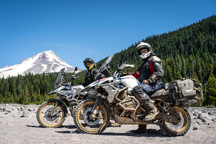
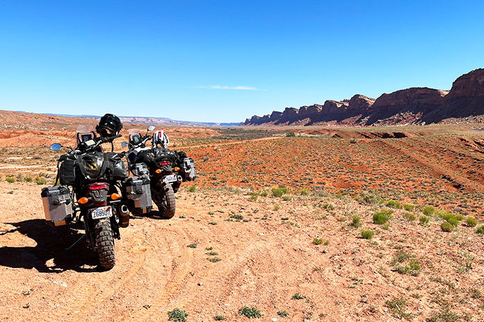
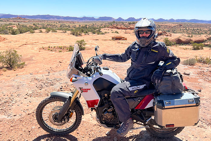
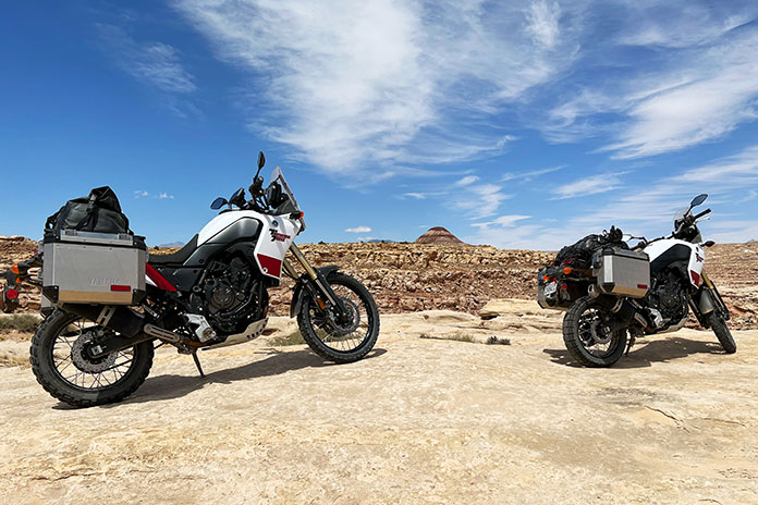
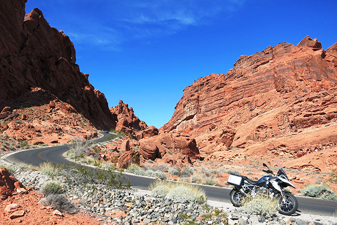
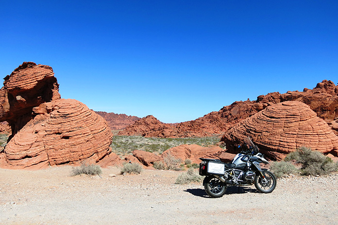
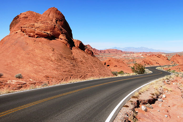
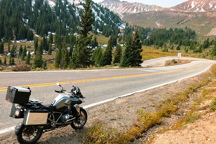
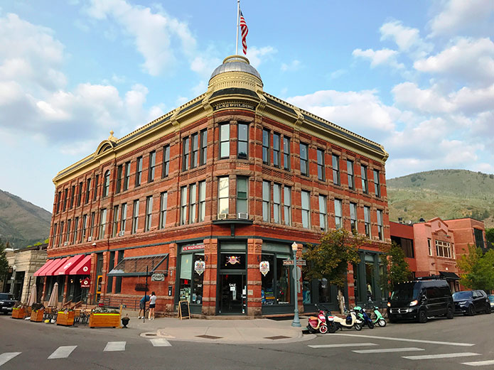
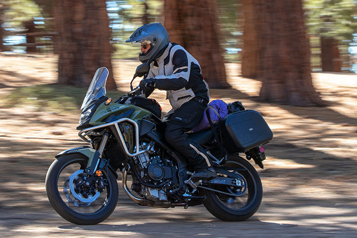
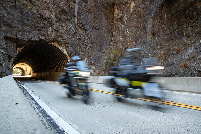
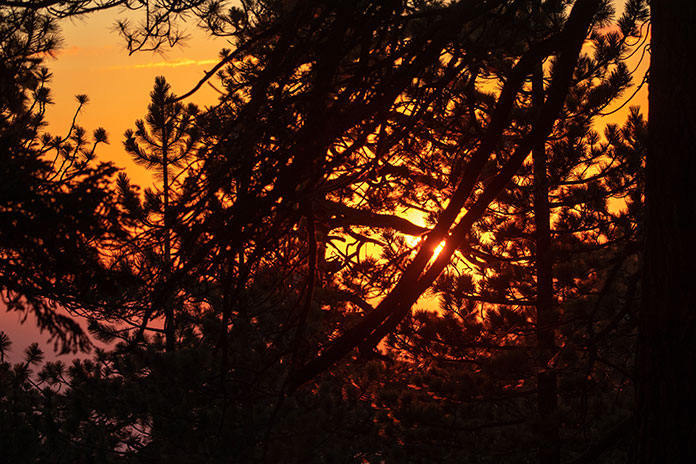
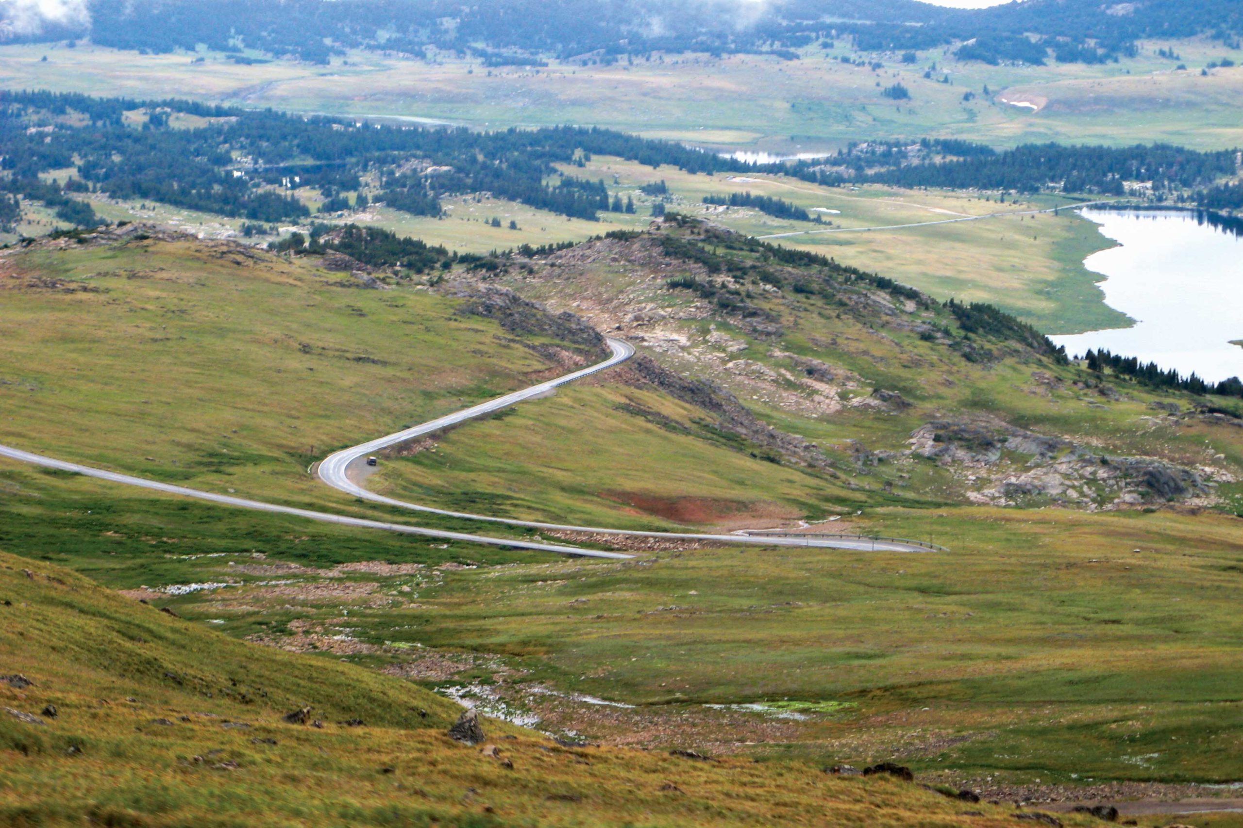
Backcountry Discovery Routes Steens Mountains and Alvord Desert, Oregon, BDR-X (Photo by Ely Woody)
Earlier this year, Backcountry Discovery Routes (BDR) released the Oregon BDR, its 12th full route, and each one can be completed in about a week. BDR has also released shorter BDR-X routes that are loops that can be done in two to three days. Read the press release below to learn more about the latest BDR-X route.
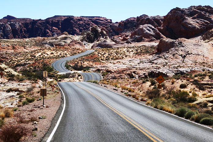
Backcountry Discovery Routes Steens Mountains and Alvord Desert, Oregon, BDR-X (Photo by Ely Woody)
The adventure motorcycling nonprofit Backcountry Discovery Routes (BDR) will release its next route, the Steens Mountain and Alvord Desert, Oregon BDR-X, during a live YouTube broadcast on June 7th from Mosko Moto headquarters in White Salmon, Washington.
Hosts BDR Executive Director Inna Thorn, route co-architect Nathan Fant, and Mosko Moto CEO Pete Day will premiere the short expedition documentary film and offer viewers a behind-the-scenes look at the creation of the route.
Wednesday, June 7, 2023
Steens Mountain & Alvord Desert BDR-X Live Route Release
Backcountry Discovery Routes Steens Mountains and Alvord Desert, Oregon, BDR-X (Photo by Ely Woody)
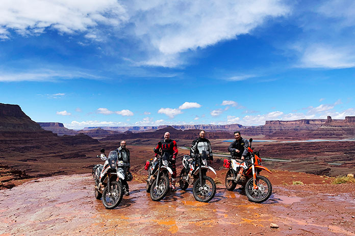
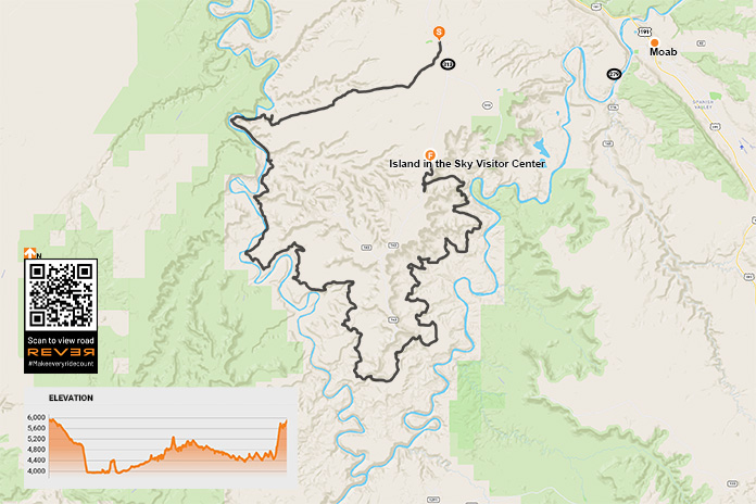
The Steens Mountain and Alvord Desert BDR-X is the organization’s fifteenth route and fourth in the BDR-X series of shorter BDR-style loops. Free GPS tracks, travel resources, and a downloadable/printable map will be available at RideBDR.com/AlvordDesert.
“We created this BDR-X because Steens Mountain has to been seen to be believed. Far different than the Cascades or Rockies, this remote mountain has deep glacier-carved gorges and views down to the vast Alvord Desert that riders get to experience on the second day. It’s an awe-inspiring loop that riders will never forget.” — Bryce Stevens, BDR co-founder and route architect
Mosko Moto is the presenting sponsor of this route. The luggage and apparel manufacturer is headquartered in White Salmon, WA, and is perfectly situated between the end of the ORBDR and the start of the WABDR. For BDR riders, Mosko offers free camping at the Bates Mototel – about 5 miles from downtown White Salmon (reserve a site by email). Mosko’s Co-Founder and CEO joined the filming expedition.
“The Alvord is one of my favorite places in the world. The wide open spaces, the absence of noise, clutter, and people. Dark skies and vivid stars. It’s a very special place, and it’s far from everything, which is kind of the point.” — Pete Day, Mosko Moto Co-Founder & CEO
About The Backcountry Discovery Routes OR BDR-X
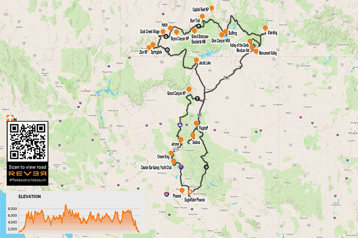
Designed to showcase the striking 5,000-foot elevation transition from the Steens Mountain to the Alvord Desert, this remote BDR-X starts and ends in Fields, Oregon (near section 1 of the Oregon BDR). The 246-mile loop can be accomplished in two days and offers a diverse mix of surface terrain, including gravel roads, rocky double-track, overgrown dirt roads, and open desert playa making this BDR-X truly unique. This 2-day loop is accessible after the snow melts and the roads open in June.
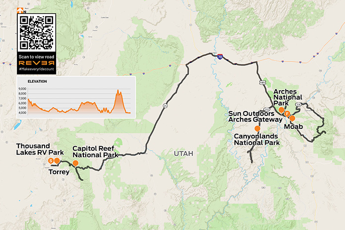
Utah’s national parks – Arches, Bryce Canyon, Canyonlands, Capitol Reef, and Zion – are known as the Mighty 5. All feature impressive red rock formations, landscapes, and vistas, yet each is unique. In late September, after the worst of the summer heat and crowds, my wife and I toured three Utah National Parks on a motorcycle.
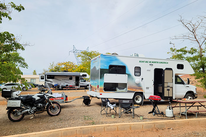
We were coming from California. Younger riders or those with iron butts may choose to endure the entire journey on two wheels, but we prefer burning the hundreds of interstate miles to get there and back in comfort, and we like to bring more for a two-week trip than can fit on a bike. We rented an RV and a trailer, loaded up my BMW R 1200 GS, stocked up on gear, food, beer, and wine, and hit the road from our home in Oxnard.
We “glamped” in RV parks, all of which had wide pull-through spots with plenty of trailer and bike parking. Once parked, we saddled up for scenic day rides. Being on a motorcycle made it easier to cruise through the national parks and slip into smaller parking spaces. At the end of each day, we returned to our campsite for a sundowner by the fire. For this trip, we purchased a National Parks and Federal Recreational Lands Pass for $80, which paid for itself upon entrance to our third park and gave us access to other parks for a full year.
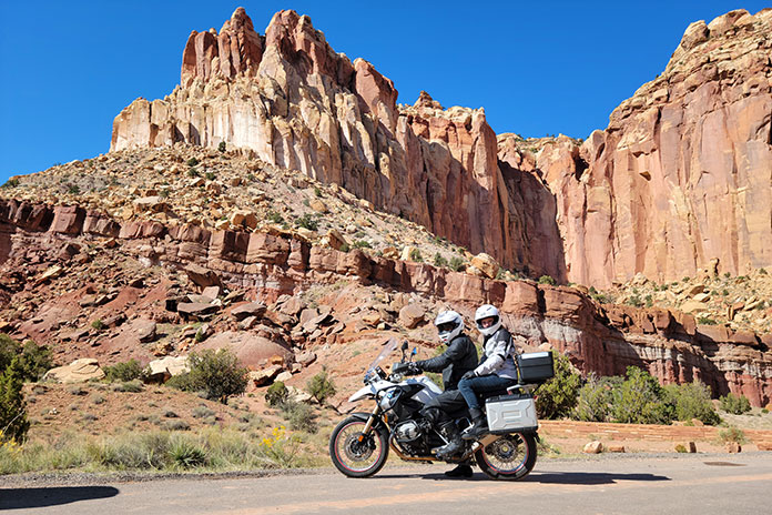
On a perfect 70-degree clear day, we mounted the GS, departed Thousand Lakes RV Park in Torrey, Utah, and rode into Capitol Reef National Park, known for its 100-mile wrinkle in the earth’s crust called the Waterpocket Fold. It was formed as rocks were pushed upward and erosion sliced and diced through the layers, creating deep, narrow canyons and towering monoliths.
Capitol Reef got its name because early settlers thought the Navajo sandstone resembled the U.S. Capitol.
We rode past Panoramic Point down a short washboard dirt road to Goosenecks Overlook. I changed the GS’s suspension setting to Comfort mode and promptly received a “Thanks, Babe” from Nicole via our helmet comms. The view from Goosenecks Overlook of the river below and the slender S-curve it cut into the canyon was splendid.
Continuing into the park, we turned right at the visitor center onto Capitol Reef Scenic Drive, a paved road that turns to dirt after 8 miles at the Capitol Gorge Road picnic area. There is so much to see in all directions that we poked along at about 20 mph. Coming back, we turned onto a bumpy 2-mile dirt road and rode through a couple dry washes to the Cassidy Arch trailhead and Grand Wash. I checked the horizon for storms, as even distant rain could quickly make those washes impassable. The scenery as we approached the trailhead changed dramatically, making the detour a must-do.
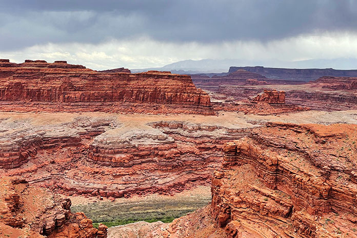
Utah National Parks on a Motorcycle: Canyonlands
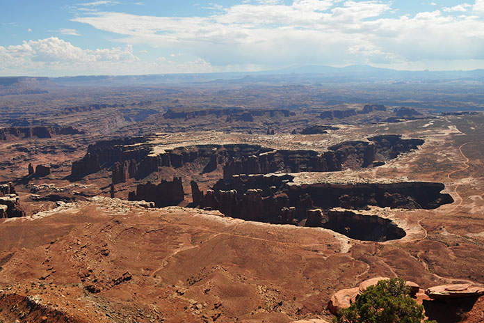
From Grand View Point in Canyonlands, the Colorado River and Green River canyons look like a giant chicken footprint in the plateau.
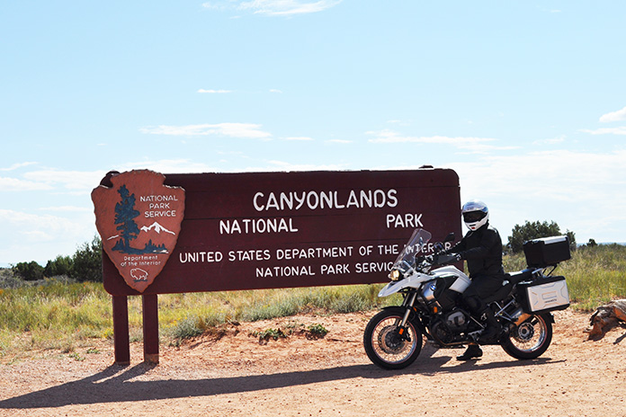
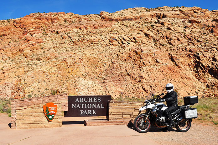
Due to a late start from our campsite at the Sun Outdoors Arches Gateway in Moab, we were turned away from Arches because it was at capacity. Even in the “shoulder” season, high-traffic parks like Arches fill up early, so depending on when you go, plan ahead and reserve a timed entry ticket. Even though Canyonlands is only a few miles from Arches, it gets much less traffic, so we headed there instead.
Canyonlands is made up of three districts: Island in the Sky (which we visited), The Needles, and The Maze.
We had to wait to get into Canyonlands too, but Nicole and I passed the time by chatting and digging into our bag of snacks. Following the requisite snapshot at the park entrance sign, we proceeded along the huge flat-topped Island in the Sky Mesa and the 34-mile roundtrip paved road that connects the panoramic viewpoints. These overlooks are 1,000 feet above the surrounding terrain, so the views are spectacular.
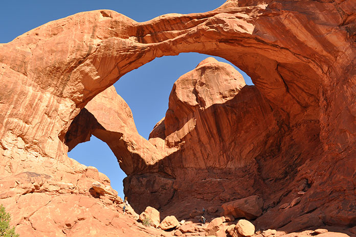
Utah National Parks on a Motorcycle: Arches
Double Arch in Arches National Park is a pothole arch formed by erosion from above.
A much earlier start the next day paid off. We began the tour of Arches at The Windows Section, home of Double Arch, the Parade of Elephants formation, North Window, and Turret Arch. We brought shorts and tennis shoes to comfortably walk amongst the sites, as well as a picnic lunch. My favorite was Double Arch, a pothole arch with a span that’s 144 feet wide and 112 feet high formed by water erosion from above rather than more typical erosion from the side.
A brisk 10-minute walk took us to North Window, standing 93 feet wide and 51 feet high, where we stumbled upon a group of local grade-schoolers with canvas and paintbrushes in hand, tapping into their inner artist. “Don’t get too focused on the sky, or you’ll end up with too much blue in your painting,” advised their teacher. We continued on and then enjoyed the solitude and scenery of the Windows Primitive Loop trail.
Arches fills up fast, so get there early.
Back on the bike, other highlights included the Garden of Eden, Balanced Rock, and Wolfe Ranch, which is located at the trailhead that leads to the famous Delicate Arch featured on Utah license plates.
On a cloudy 62-degree morning, we followed U.S. Route 191 south out of Moab and made our way to La Sal Loop Road, a winding paved route that climbs up into the La Sal Mountains. The temperature dropped and it began to rain, but luckily the road turned away from the storm.
Moab serves as a great base for scenic day rides. After visiting Canyonlands and Arches, we climbed out of the valley on La Sal Loop Road, where we enjoyed the fall colors of the aspens.
“Are you warm enough?” I asked Nicole, and when she answered in the affirmative, we pressed on. Just beyond the parking area for Mill Creek, we turned right onto Forest Road 076 toward Oowah Lake. This bumpy, rutted dirt road challenged me with sharp corners, steep climbs, and wandering bovines, but we were rewarded with the fall colors of the aspens.
We took this dirt road of the main La Sal Loop Road in order to get to Oowah Lake.
We continued our counterclockwise ride on La Sal Loop Road. We stopped at La Sal Lookout Point, which provides sweeping views of Castle Valley and red rock formations that look like the inspiration for the old cartoons with the Road Runner and Wile E. Coyote. A steep descent with multiple switchbacks took us down to the warmer air of the valley floor. At State Route 128, we turned left (west) and followed the Colorado River on our way back to Moab.
RV camping allowed us to travel in comfort.
With so much great riding and scenery, we were reluctant to leave, but our allocated vacation time was coming to an end, so we packed up and headed home. Southern Utah is a stunning part of the country that should be on everyone’s must-see, must-ride list.
Following the success of the first partnership between BMW Motorrad USA and Backcountry Discovery Routes in 2022 with the Wyoming BDR, the two groups have announced a second partnership for a route in Oregon. The new route will be officially launched Saturday, Feb. 4, at the premiere screening of the ORBDR Expedition documentary in Portland and other select locations around the nation. For more information, read the press release below from BMW Motorrad USA.
BMW Motorrad USA is excited to announce its second partnership with adventure motorcycling nonprofit, Backcountry Discovery Routes (BDR) on their newest route – Oregon. This is the second BDR route on which BMW Motorrad has collaborated, the first being the Wyoming BDR, released in 2022.
The ORBDR represents the organization’s 12th route for adventure and dual-sport motorcycle travel, with free GPS tracks, travel resources, and a Butler Motorcycle Map scheduled to accompany the film’s debut.
Luciana Francisco, BMW Motorrad USA head of brand and marketing, said BMW Motorrad is proud to partner with Backcountry Discovery Routes for the second time in two years.
“In 2023, BMW Motorrad celebrates its 100th year anniversary and also marks 43 years of BMW GS motorcycles,” Francisco said. “This is the perfect time to share our passion for the adventure and dual-sport riding communities and show our continued support for the BDR organization and what they stand for. We look forward to both new and experienced off-road enthusiasts being inspired by the scenic routes of the ORBDR.”
To launch of the new Oregon route, Backcountry Discovery Routes and BMW Motorrad will kick-off with a film premiere event in Portland, Oregon, and selected BMW Motorrad dealer events on Saturday, Feb. 4. Additionally, over 70 film screenings are planned through spring 2023, hosted by dealers and clubs around the country. More information on the film screening locations is available at the Backcountry Discovery Routes events webpage.
The ORBDR expedition film features members of the BDR team and special guests from BMW Motorrad USA, Mosko Moto, and Edelweiss Bike Travel as they take a first run on the all-new ORBDR. Starting in the high desert landscapes of Southeastern Oregon and exploring North into the Cascade Range, the crew tests their endurance, riding cross-state through 750 miles of lava rock, silt, sand, and steep mountain roads. Highlighting the state’s many natural wonders including hot springs, pyroducts, caverns, buttes, and glaciated volcanoes, the route and film showcases why traveling by motorcycle is one of the best ways to discover the backcountry of Oregon.
Story continues below trailer for ORBDR Expedition
Bryce Stevens, Oregon Route architect & BDR co-founder grew up in the Pacific Northwest and said he has “always been fascinated by volcanoes.”
“The ORBDR is a route filled with natural wonders of the volcanic kind. We designed the ORBDR to show off different regions of the state and keep the route ever-changing,” Stevens said. “Oregon has vast high desert in the southeast, sparse pine forests in the central part of the state, and densely forested mountains in the Cascade Range. It almost feels like three BDRs packed into one.”
Joining the expedition team in Oregon was Ricardo Rodriguez, lead motorcycle instructor at BMW’s U.S. Rider Academy in Greer, South Carolina. Ricardo is a graduate of BMW’s rigorous International Instructor’s Academy and has been teaching on-road street survival, adventure off-road, and authority riding skills since 2010.
“The BDR Team has set out on a fantastic mission, helping keep public lands accessible to the adventure community,” he said. “I am very proud and excited about the relationship between BDR, BMW Motorrad, and the BMW U.S. Rider Academy. Having the opportunity to be a part of the Oregon BDR has helped build my experience as a rider and a coach. Overcoming the challenges along the ORBDR reinforced to me the value of the skills we teach daily at the US Rider Academy.”
Rodriguez continued to say that Backcountry Discovery Routes offers properly trained riders an opportunity to put their skills to the test.
“The Oregon BDR is a challenge and reward riding adventure.”
Taking a rehydration break along the Colorado River while our Yamaha Ténéré 700s waited patiently.
During the long, dark winter in Minnesota, when the ground is covered in snow and ice and our motorcycles are mothballed for months, dreaming about riding in a warm, dry place gives us hope. That’s when my friend Craig and I started planning an adventure ride out West. We sketched out a route that included a mix of backroads, parts of the Arizona and Utah Backcountry Discovery Routes, other off-road tracks, and interesting sights along the way.
In May, we flew into Phoenix and headed to EagleRider in nearby Mesa, where we were greeted by a friendly guy named Bob. After a quick paperwork checkout procedure, we packed our gear on two rented Yamaha Ténéré 700s and headed north on Interstate 17.
With temperatures in the triple digits, the frigid days of winter seemed like a distant memory, so we busted north to gain some elevation.
Even in full riding gear, we started to cool off as we rode farther north. Our bikes were unfamiliar to us, and they were stuffed to the gunwales with camping gear and other essentials. We soon grew accustomed to their added weight as we passed over the “Carefree Highway,” a 30-mile stretch of road made famous by Canadian singer Gordon Lightfoot that runs between I-17 and U.S. Route 60.
I have a lot of street miles under my belt, but this was my first adventure bike trip, so I wasn’t entirely prepared for the primitive roads where the gravel feels like marbles under your wheels. However, it didn’t take long for the combination of my ancient dirtbike experience and a few unplanned rear-wheel kickouts to provide a quick education on keeping the Ténéré upright. Enthusiasm tempered with caution was the order of the day.
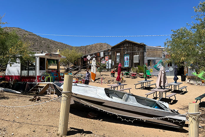
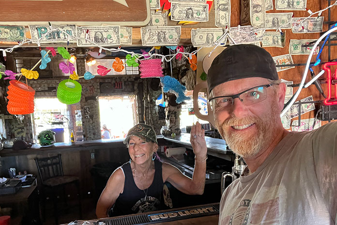
We took County Road 59/Bumble Bee Road off I-17 to check out the Cleator Bar and Yacht Club. The name of this welcoming 4×4 oasis run by Tina Barnhart is a bit tongue-in-cheek, as it is located hundreds of miles from open water. Barnhart is also in the vehicle delivery business to such faraway places as Africa and is active in the Global Rescue Project based in Scottsdale, Arizona, which works to end child slavery and reunite children with their families.
Boats in the Yacht Club’s “marina.”
The Cleator Bar is a must-stop location, complete with boats in the “marina” out back and a stage for live music. Interestingly, the entire town of Cleator, comprising 40 acres, a bar, a general store, a few other structures, and mineral rights, was put on the market by descendants of James P. Cleator in 2020 for $1.25 million, and it was sold at the bargain price of $956,000.
Hanging out with Tina Barnhart while we cooled off at the Cleator Bar and Yacht Club.
Our next stop was Crown King, located another 13 miles along CR 59 at an elevation of 5,771 feet. A high-clearance four-wheel-drive vehicle is recommended on the deteriorated roads. The Ténérés managed well, and we soon found ourselves taking a load off in the Crown King Saloon & Eatery, one of the oldest continuously operated saloons in the state. We enjoyed a cold drink and a hearty lunch, and the $5 bottle of scotch we bought there (on sale courtesy of Mother’s Day) served us well during the rest of the trip.
We were surprised to see so much green in the Bradshaw Mountains.
Like a lot of small towns in the Bradshaw Mountains of Arizona, Crown King used to be a thriving mining community. In 1904, a railroad was built to help mining operations, but due to a lack of water and high transportation costs to process the ore, it was abandoned in 1926. The old railroad bed is still used today as the main access road to Crown King.
While there, we met Chuck Hall, who is a great ambassador for the area – and a talented guitar picker to boot. He told us he’d lived there for over 30 years and recommended we check out the Senator Highway, on which he’d lost many an exhaust pipe from his old Dodge Neon. A former stagecoach route, the rutted road snakes 37 miles from Crown King to Prescott with many blind switchbacks, eroded surfaces, several water crossings, and spectacular scenery.
Craig takes a breather on part of the Utah Backcountry Discovery Route.
Hall recommended we visit Palace Station, a stage stop built in 1878 midway between Crown King and Prescott. Back in the day, the station had a bar and was a social meeting center for the miners who worked in the area.
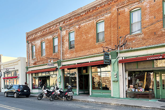
We targeted the town of Jerome for the night. This old copper mining town earned its nickname, “Wickedest Town in the West,” during its heyday in the early 20th century. After the mining bust, the town descended into desperation, greed, and crime. It was revived in the 1960s as a tourist destination, and many of its historic buildings are now filled with restaurants, shops, and hotels. Jerome is said to be a hotbed of paranormal activity, and we stayed at the Connor Hotel, which is reportedly haunted by the “Lady in Red.” We didn’t see any ghosts, so maybe she had the night off.
Downtown Jerome, the “Wickedest Town in the West.”
With a long day of off-roading ahead, we left Jerome and headed north toward the Grand Canyon on a series of unpaved national forest roads. We wound our way around the contours of Woodchute Mountain, crossed the Verde River, and ascended to the Colorado Plateau at more than 6,000 feet. We could see the volcanic San Francisco Peaks rising above the plateau to the east.
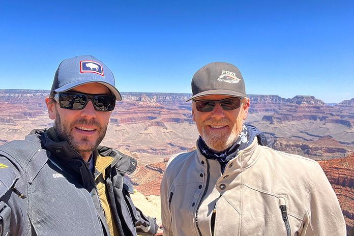
We crossed Interstate 40 near Williams, and after a few miles on State Route 64, we turned onto a national forest road to take an unpaved “back door” route into Grand Canyon National Park. We hooked up with Route 64 again where it’s known as East Rim Drive and enjoyed scenic views from the Grand Canyon’s South Rim.
Craig (on left) and me at the South Rim of the Grand Canyon – a million miles away from our home in Minnesota.
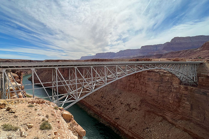
After leaving the park, we connected with U.S. Route 89 and refueled at Cameron, where the highway crosses the Little Colorado River. At Bitter Springs, U.S. 89 splits to the east toward Page, but we continued north on U.S. Route 89A, crossing the Colorado River at Marble Canyon via the Navajo Bridge and following 89A west into an area known as the Arizona Strip. We rode with the majestic Vermilion Cliffs to our right, crossed House Rock Valley, and then climbed out of the desert and into the evergreens of the Kaibab Plateau.
The Navajo Bridge crosses the Colorado River at Marble Canyon, and in the background is Vermilion Cliffs National Monument.
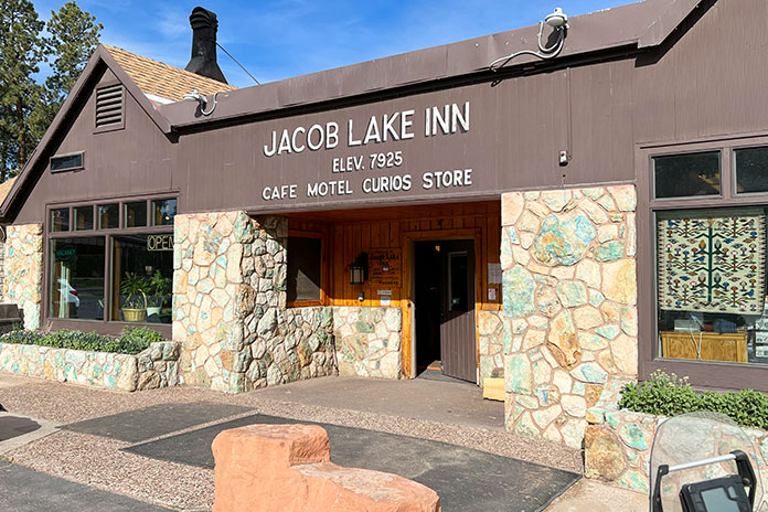
We stopped at Jacob Lake, a small crossroads that sits at 7,925 feet, and it was noticeably cooler at the higher elevation. Known as the gateway to the North Rim of the Grand Canyon, Jacob Lake has a gas station and a hotel with a restaurant and gift shop. The town was named after Jacob Hamblin, an early Mormon pioneer who was shown the location in the mid-1800s by the Kaibab band of Southern Paiutes. And according to the hotel staff, the lake is more of a pond.
Jacob Lake, Arizona, is near the North Rim of the Grand Canyon.
We continued west through Fredonia and crossed into Utah near Kanab, known locally as “Little Hollywood” because of its rich history in filmmaking – most notably Westerns, with more than 100 movies and television shows being filmed there.
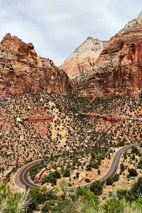
Thus far we had stayed at motels, so we weren’t exactly roughing it. We decided we needed to get some use out of the camping gear we’d been lugging around. After riding through Zion National Park, where we were blown away by the majesty of the cliff faces and rock formations, we traversed the Dixie National Forest through Duck Creek Village to Hatch, where we found suitable dispersed camping.
Utah State Route 9 winds through incomparable scenery in Zion National Park.
It had been about 20 years since my last camping experience. I narrowly avoided putting an eye out with the tent poles, and after the camp was set and the fire built, it felt good to relax with that $5 bottle of scotch. It was a clear night, and the 7,000-foot elevation yielded cool temperatures. With the fire all but gone, it was time to turn in for the night. I live in Minnesota and am no stranger to the cold, but I clocked 19 degrees overnight in that campsite and don’t think I have ever been so happy to see the sun start to rise. Note to self: Next time bring a sleeping bag rated below 30 degrees.
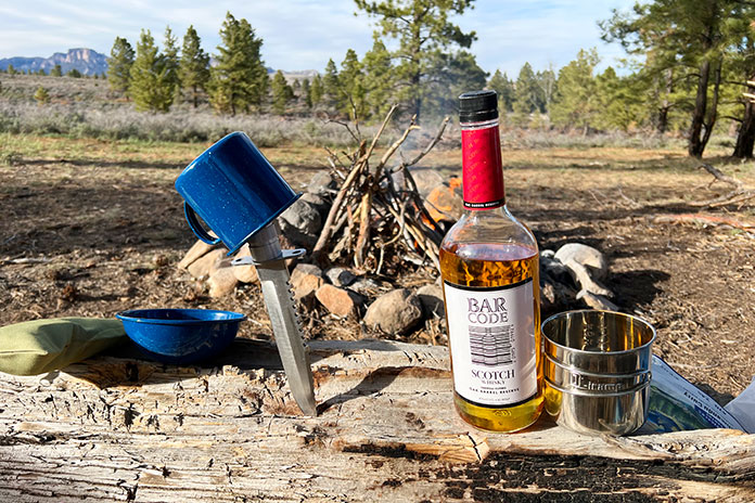
Around the campfire, we sampled the $5 bottle of scotch we bought at the Crown King Saloon. To paraphrase Mark Twain, the coldest night I ever spent camping was during May in Utah.
Once packed up, we put Hatch in the rear view and were soon heading east on Utah’s stunning State Route 12, known as one of the most scenic highways in the nation. We visited Bryce Canyon National Park and its many rock spires and hoodoos and rode through the vastness of Grand Staircase-Escalante National Monument.
At Boulder, we left the pavement and took the Burr Trail, a well-known backcountry route that passes through Capitol Reef National Park on its way to the Bullfrog Basin in the Glen Canyon National Recreation Area. The trail was named for John Burr, a cattle rancher who developed the route to move his cattle between winter and summer ranges. The country was nearly impassable then and continues to be challenging to this day, with RVs and trailers “not recommended.” Southern Utah is one amazing vista after another, and this stretch featured outstanding scenery as well as many switchbacks on loose gravel that kept us on our toes.
Switchbacks and elevation changes as far as the eye can see on the Burr Trail in Utah.
Throughout the trip, we’d been battered by winds that were contributing to fire restrictions in Arizona and Utah. At this point, the wind was howling, with 50-mph gusts giving us a good sand blasting. After a quick stop in Bullfrog, we headed north on State Route 276 and then south on State Route 95 to Hite Crossing over the Colorado River.
We had violated our “never pass gas” top-off policy in Bullfrog, expecting to find a place to refuel in Fry Canyon. Given the time of year and possibly other reasons unknown, the gas pumps were closed in Fry, so we pushed on through some gorgeous country that might’ve been easier to appreciate if we weren’t worried about our dwindling fuel.
At one point, we pulled over to assess the situation. Craig had been smart enough to fill his reserve bottle, which he poured into his tank. My bike was still showing a couple bars of fuel left. I tip my cap to the Yamaha Ténéré 700. Even though my fuel gauge was blinking “empty” and both of us were expecting the pullover of shame, we made it all the way to Blanding. The Arch Canyon Inn was a welcome stop, but being informed that it’s a dry town put the “bland” in Blanding.
Travelers in a strange land. Parts of Utah felt like being on another planet.
Leaving Blanding and getting on the Utah BDR was like visiting another planet. The Butler and Comb washes, the Moki Dugway, and Valley of the Gods were some of our favorite parts of this trip. With all the distinct rock formations, it was a challenge to stay focused on the trail and not get distracted by the scenery. In most cases, one blown turn can mean disaster, but the rewards are more than worth the risks. Again, caution saved the day.
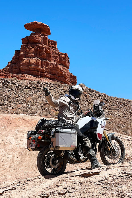
The southern terminus of the Utah BDR is in the town of Mexican Hat, which I assumed was named after a mountain resembling a sombrero. Turns out, it is a distinctive disc-shaped rock about 60 feet in diameter that’s perched atop a smaller base at the top of a mesa. I’ll always remember it as the site of my first involuntary dismount from the Yamaha during a charge up a softer-than-expected mound of sand.
At the southern terminus of the Utah BDR in Mexican Hat. Behind me is the town’s namesake rock and below me is softer-than-expected sand.
The area around Mexican Hat borders the northern section of the Navajo Nation into Monument Valley. This area is considered the sacred heart of Navajo country, and you can’t help but marvel at how iconic the straight-line stretch of road is as it leads into the horizon, framed with towering sandstone rock formations. Hiking in the park is highly restricted, with only one path that can be hiked without a guide. Monument Valley Trail Park had been previously closed after a movie crew was caught filming without a permit. It is now reopened at a reduced occupancy limit, but no motorcycles are permitted on the 17-mile loop due to deep sand dunes in the area.
Dispersed camping near Hatch, Utah.
Back in Arizona, we cruised paved highways to Flagstaff and then down into Sedona. Determined to camp at a lower (read: warmer) elevation, we found the Lo Lo Mai Springs Outdoor Resort. Lo lo mai is a Hopi Indian word that represents a greeting with many meanings, similar to the Hawaiian aloha. It also means “beautiful,” which the owners of Lo Lo Mai Springs say is where the resort’s name originated. The area borders spring-fed Oak Creek, which is a valuable and rare natural water source in this part of Arizona. The campground had some welcome amenities and was a lot warmer than the prior camping stop.
Monument Valley.
We spent our last day exploring some of the Arizona BDR tracks in the Coconino National Forest near Sedona and Flagstaff. With time running out, we finally hopped on State Route 87 and burned the final miles to Scottsdale, where the town was alive with nightlife.
Returning the bikes was bittersweet. Bob welcomed us back, relieved that the Ténérés had only a layer of dust and a bit less rubber on their tires after 1,591 on- and off-road miles. As we grabbed an Uber to the airport, I could not help but realize the vast additional riding world that adventure motorcycling opens up. Soon after getting home, I put one of my streetbikes up for sale, and an adventure bike could be in my future.
The roads in Nevada’s Valley of Fire State Park cut through some of the world’s most stunning red rock formations.
Johnny Cash sang about fire, murder, heartbreak, and sin, and I think he would have appreciated the symbolism of this ride, given its route. Northeast of Las Vegas is one of the most visually stunning state parks in the Southwest. The added bonus for motorcyclists is that the park’s roads trace through the crimson landscape like slithering black mambas. A ride through Valley of Fire State Park and Lake Mead National Recreation Area makes for a fantastic motorized respite from the neon bustle of Vegas.
The Las Vegas Strip, with its massive themed casinos, sidewalk solicitations, and congestion, is not my cup of tea. That’s why my staging point for this ride was Fremont Street. While still over-the-top, this area has the feel of an older, more genuine version of Vegas.
The night before my ride, I watched a cover band play classic rock tunes under the lights and video canopy that spans Fremont and enjoyed a variety of street performers. The next day, I put a couple bottles of water and lunch in the saddlebags of my BMW R 1200 GS and mounted up.
Fremont Street is well north of the traffic and congestion of the Strip, so getting out of the city was much more convenient than it would have been if I had opted for lodging at one of the mega-casinos. On my way out of town, I rode past the Mob Museum and the Neon Museum – Vegas-themed tributes that were added to my post-ride entertainment schedule.
The Las Vegas Wash runs as a tributary to Lake Mead, adding yet another unique visual element to this great ride.
The cruise northeast on the Las Vegas Freeway (Interstate 15) was a nice warm-up to this loop ride. The muted hues and desert views were expansive as I climbed out of the neon valley. There were a few floating cotton balls in the otherwise intense blue of the mid-morning Nevada sky. The line where the horizon meets the sky was as crisp and sharp as I have ever seen.
After 30 miles of motoring on the freeway, I diverted the GS eastward onto the Valley of Fire Highway. The two-lane tarmac starts as a gently curving and undulating climb into the gray stone mountains that were part of the striking delineation I enjoyed just miles before. However, the monochromatic gray soon gives way to vibrant blotches of crimson. Contemplating the name of the Valley of Fire State Park, I couldn’t help but imagine those red spots as flare-ups caused by the wind-carried embers of an approaching wildfire.
The various hues of the desert landscape in the Valley of Fire make for a ride with an almost cinematic feel.
My first stop in the park was at the aptly named Beehives. There is little doubt what all the buzz is about. Cringe-worthy puns aside, the Beehives are a spectacular object lesson on the artistic creativity of erosion. The hives are stratified tributes to the power of wind, water, and time.
The Beehives are whimsical sentinels that add to the region’s other-worldly feel.
By the time I got to the turnoff for the park’s visitor center, I was fully engulfed in the figurative flames of the Valley of Fire. I live near Sedona, Arizona, and I have ridden extensively through the red rocks of southern Utah, so I have a solid base of reference for the hue of red sandstone. Valley of Fire is something different. The terrain carries a deeper, more blood-like patina in this region. It is stunning.
The smooth and well-maintained winding roads through the Valley of Fire are tailor-made for motorcycling.
I bought a $10 park pass at a self-serve kiosk and rode up Mouse’s Tank Road. The endgame of this beautiful ride was a short hike on The White Domes Trail, where I enjoyed a drink of water and a snack and took in the majesty.
I am not usually a fan of out-and-back routes; however, this ride, carving through the curvaceous rock formations of the park, is fantastic in both directions. It’s only about 6 miles from the visitor center to the end of Mouse’s Tank Road, so the ride through the heart of the park is short but very scenic.
The mix of elevation changes and a smorgasbord of turns makes the ride through the Valley of Fire very entertaining.
Back on the Valley of Fire Highway, I was awed at the beauty around me. The road follows the undulations and sinews of the red rocks. I made a final stop at Elephant Rock and meandered up the trail in my Sidi boots. It was well worth the wear on the soles of those expensive kicks. Elephant Rock is yet another of the park’s formations that is stunningly indicative of nature’s wonders.
If this were a full daytrip rather than a through-ride, I would have stopped and hiked several more of the park’s features, like Arch Rock and Atlatl Rock with its Native American petroglyphs. The park is deserving of more exploration than I was able to give it.
A fellow biker gives the universal salute as he rolls through Lake Mead National Recreation Area.
Back on the BMW, I made my way to the end of the park’s highway at its intersection with North Shore Road (State Route 167). The referenced shore is the bank of Lake Mead. The “shore road” moniker is a bit of a misnomer. The Southwest’s unprecedented drought has drawn the reservoir down to a record low, so I was quite some distance from the lake. While not a waterside trek, the ride in the Lake Mead National Recreation Area is entertaining and beautiful. I was back in that fringe environment where red outcroppings dot the gray landscape. The fire was to my back this time.
The terrain within Lake Mead National Recreation Area is stark, barren, and beautiful.
Farther west on my return toward Vegas, the flatter, muted desert landscape returned. Cactus, desert brush, and the occasional dwarf palm dotted the horizon, and the final leg was relaxing as I traveled back from the Valley of Fire to the valley of neon. With proper gear choices, this is a ride that can be made virtually year-round, and I will certainly be back. From the City of Sin to the Valley of Fire, it’s a heavenly ride indeed. The Man in Black would approve.
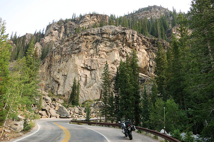
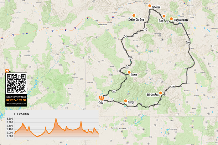
Rugged mountains, evergreen spires, historic towns, and fantastic curves highlight this loop ride through western Colorado.
As I sat in the grassy courtyard of the Retro Motel in Cortez, Colorado, the quaint motel’s name struck a chord. It dawned on me that “retro” may be the theme of this western Colorado motorcycle ride. Merriam-Webster defines “retro” as something “fashionably nostalgic.” That seemed fitting as I contemplated a loop ride that would take me deep into the Rocky Mountains and through some of western Colorado’s iconic towns. The most famous of these towns are deeply rooted in frontier history but have since taken on the upscale air of ski-chic and Western high fashion.
After a slug of coffee and a nibble of the motel’s grab-n-go breakfast, I headed north out of Cortez on State Route 145. In no time, I was rolling through the tiny town of Dolores. From there, I began a beautiful ride that follows the Dolores River for a long stretch and gains elevation. The route is a pleasant mix of short straights and sweeping corners.
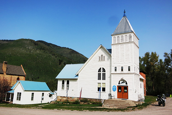
As I parted ways with the clear waters of the Dolores, the corners tightened and the air cooled. After a spirited ride, I motored into the historic silver mining town of Rico, which was settled in 1879 and still boasts impressive historic structures for such a tiny place. I dropped a kickstand at the town hall and the community church, both of which were constructed in the early 1890s and are remarkably well-preserved.
The whitewashed Rico Community Church was built in 1891 and restored in 1993.
I had gained almost 3,000 feet in elevation in the 50-mile ride from Cortez, and the mid-September leaves were changing on the winding road out of Rico. The road coiled even more as I rolled through the vibrant greens of the western Rockies.
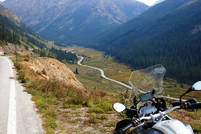
Overlooks in the Rockies often reveal the great tarmac that is to come.
This isn’t the first time I’ve been in this area, and memories occupied my thoughts as I made the short jaunt into Telluride. The Victorian silver mining town, which sits in an impressive box canyon, was founded around the same time as Rico. The area’s economy has shifted from mining to skiing and tourism. Telluride is now distinctively upscale while retaining its Victorian charm. I rode past high-end boutiques peddling their pricey wares from within historic brick facades.
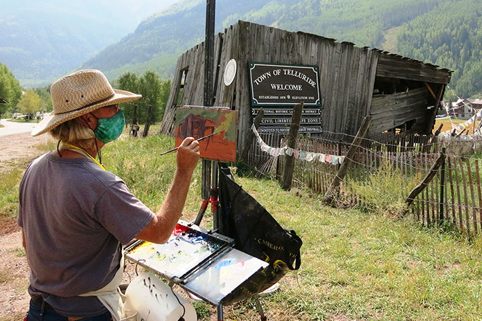
A painter practices his art on the outskirts of Telluride.
My reminiscing hit full tilt as I made it to Telluride Town Park, where my wife and I attended the Ride Music Festival a couple of years back. The setting is amazing, with a precipitous tree-covered mountain face as a backdrop behind the permanent concert stage. All the town’s festivals are held in this must-attend venue for music lovers. One of my favorite festival memories was listening to Pearl Jam fill the box canyon with their soaring melodic riffs. On my most recent visit, Frisbees and softballs filled the air, but I could almost hear Eddie Vedder still echoing in the evergreens.
I climbed out of Telluride to the northwest. It was good to be out of the congestion and back on the curvaceous tarmac of western Colorado. The traffic picked back up as I approached the city of Delta. After making it though the slow-and-go, I headed northeast toward Aspen.
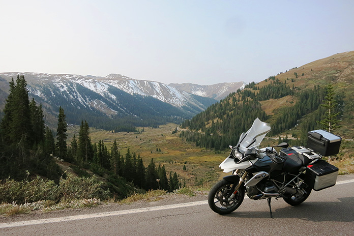
Snow-laced mountain passes are ubiquitous in the Rockies of Colorado.
This stretch is mountain motorcycling at its best. Tight curves and relaxed sweepers are the rule here, and the Rockies, which were snow-laced at the time, make the perfect backdrop. The road’s condition was remarkably good considering the weather extremes in this area. I had to slalom around the occasional pothole, but that is about it.
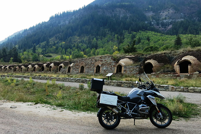
It was on this leg that I happened upon one of those “happy surprises” on a motorcycle tour. From a distance, I saw what looked like rows of mud nests made by cliff swallows – except much bigger. As I got closer, it was clear the structures were man-made and much more uniform. It turns out I was riding alongside the historic Redstone coke ovens. These brick-lined ovens were built in 1899 and were used to burn the impurities out of coal to produce “coke” for use in steel production. Fascinating stuff.
The Redstone coke ovens are a fascinating roadside attraction. Built in 1899, the brick-lined ovens were used to burn the impurities out of coal to produce “coke” for use in steel production.
Western Colorado Motorcycle Ride? Or High Plains Drifting?
I gassed up in Carbondale, which is the northernmost point on this loop ride, and then headed southeast on State Route 82. The road here was not what I had expected. Most of this stretch heading to Aspen opens up into what you might expect on the high plains of Wyoming. There are amazing views, as much of the area is wide open or lined with only intermittent lower vegetation. It was a relaxed and entertaining stretch on this last portion of the day’s riding.
As I rolled into Aspen, I couldn’t help but think of that ridiculous scene from the movie Dumb and Dumber when Jim Carrey and Jeff Daniels are nearly frozen solid when they ride into town. Thankfully, I was not on a minibike, and my gear was much more appropriate.
Local wildfires had cast a hazy pall over the otherwise idyllic landscape.
Aspen is a ski, shopping, and outdoor recreation mecca in the Rockies. Ski slopes lead from the surrounding mountains and seemingly terminate directly on the town’s main street, which is lined with stately buildings dating back to the 1800s that are impressive in both their size and architecture. After a short ride crisscrossing the roads of Aspen’s historic district, I unpacked the panniers at my lodging for the night. The Aspen Mountain Lodge was clean and comfortable, and its bubbling hot tub was just the thing to shed the day’s miles from my lower back.
My September evening walk through Aspen was an interesting mix of history, excess, and mountain charm. I strolled past families frolicking in the town’s park, women wearing outfits that likely cost more than my motorcycle, and the delightfully eclectic mix of structures throughout the town. After a couple of slices of gourmet pizza and a local brew, I settled back into my room for the night.
A boutique in Aspen exemplifies the town’s eclectic nature.
The Ride to Independence
I awoke the next day with a smile because I would get to ride one of the most thrilling roads in the Southwest, which culminates in the thin air and sweeping vistas of Independence Pass. With bags packed and fuel topped off, I headed southeast deeper into the Rockies.
Historic log structures dot the landscape in western Colorado.
Almost immediately after leaving Aspen’s city limits, the road coils into a narrow black ribbon of entertainment. The climb is steep, and the traffic is refreshingly sparse. At times, the road narrows to a single paved lane. The skeletal remains of the area’s mining heyday rise from the undulating grasslands. Spire-like evergreens reach stoically skyward, and snow traces the gray rock peaks like the marbled fat on a good steak.
The bones of historic mining structures add visual texture to this ride.
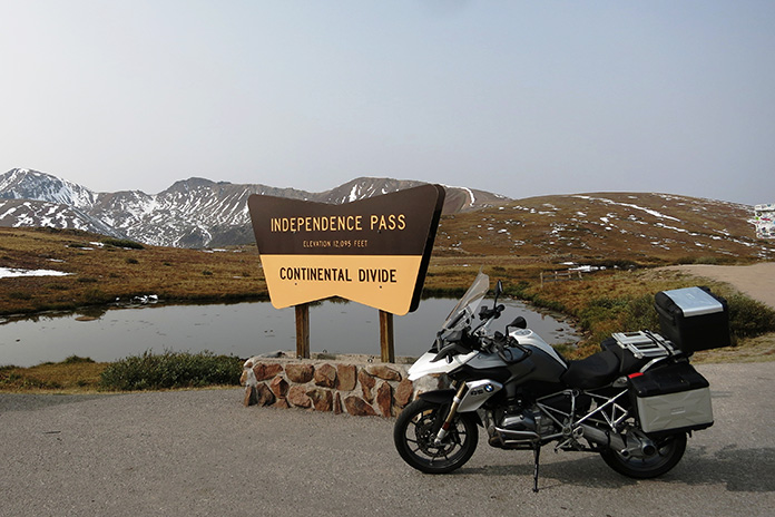
Before I knew it, I was there. The road cresting the tundra above the tree line led me to signage indicating I had reached Independence Pass. At an elevation of 12,095 feet, the summit is the highest paved pass in Colorado (but not the highest paved road; that honor belongs to Mount Evans at 14,130 feet, located about 70 miles to the northeast). I was happy that I was on a fuel-injected BMW GS, as this elevation would be rough on a carbureted bike.
Independence Pass is a thin-aired highlight of this western Colorado tour.
After the requisite photos and a moment to breathe in what little oxygen this elevation provided, I came down from the pass.
The other side of the summit was every bit as thrilling as the climb. Hairpins nearly as tight as those you’d find on a bathroom vanity abound. It’s a 1st-gear descent for the first few miles past Independence Pass, and the views are spectacular.
The visual definition of a “hairpin” curve on the southern descent of Independence Pass.
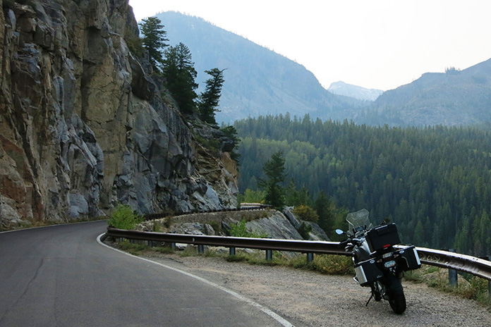
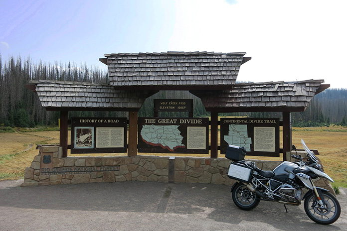
Eventually, the turns relaxed until I reached one of the few straight stretches on the loop. After that, I headed southwest on U.S. Route 160. This ultimately leads to Wolf Creek Pass. Yes, that’s the one in the 1970s song by C.W. McCall. I rode down from the nearly 11,000-foot pass amid numerous warning signs about the precipitous grade and what it can do to truck brakes. There were two runaway truck ramps on the descent that spoke to the danger.
The famed Wolf Creek Pass is a shining star of the Great Divide.
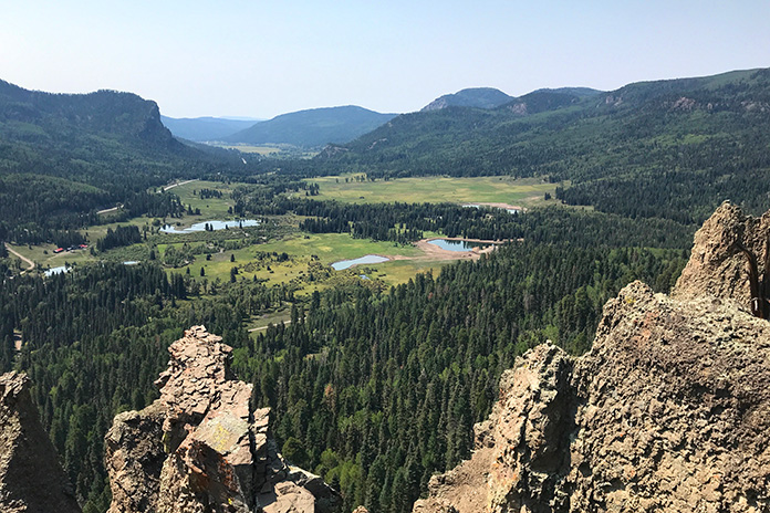
I threw down the kickstand at the viewpoint to enjoy one of the most impressive vistas on the trip. The view serves as a topographical foreshadowing of a descent through jagged rocks and vivid conifers into a grassy valley. The few miles between here and my final stopover did not disappoint.
The view south on U.S. Route 160 is stunning and expansive.
Soaking in the Last Stop of the Western Colorado Motorcycle Ride
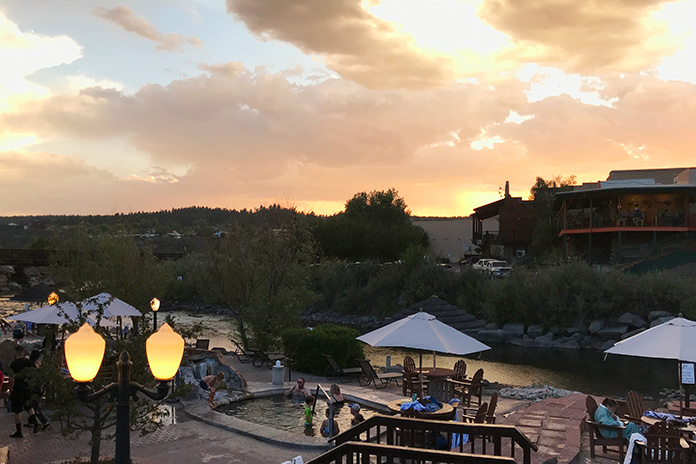
I entered Pagosa Springs road-weary but satisfied. This is another town rich in history but with the added draw of the steaming waters of the Mother Spring aquifer. I made my way to The Springs Resort and Spa, an upscale and visually stunning property that boasts two dozen soaking pools fed by the aquifer.
The natural hot pools at The Springs Resort and Spa in Pagosa Springs are perfect for soaking away the stiffness of the road.
The pools range in temperature from 88-112 degrees, and all offer amazing views of the San Juan River and surrounding mountains. After sampling several of the hot pools, I retired to my comfortable suite and drifted off with visions of the day’s amazing ride dancing in my head.
All that was left of my western Colorado loop tour was a relaxing ride due west back to my starting point in Cortez. There was, however, one more iconic town left on the docket. After about 50 miles of gently curving highway, I came upon Durango.
Durango’s Strater Hotel is one of many stately, historic structures on this ride.
This southern Colorado town is situated on the banks of the Animas River and, like all the others I have visited, has a rich history and well-preserved downtown area. I picked up a to-go sandwich and sat by the whitewater park to watch kayakers navigate the rapids. I put up the kickstand for the last time on the trip on the short jaunt back to Cortez.
Obviously, this is a summer ride. The extreme elevations make for an early winter and late-arriving summer. Some stretches on this route are permanently closed in the winter. Pack with the expectation of large swings in temperature and precipitation. Plan well and enjoy!
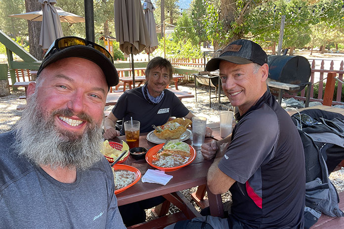
Rider’s editor-in-chief Greg Drevenstedt (left) and American Rider’s editor-in-chief Kevin Duke share a fireside toast. (Photos by Kevin Wing)
Buried deep in my iPhone is a text message I sent to my riding buddies on Feb. 29, 2008 (lucky leap day, as it turns out):
I got the job!! I’m Rider’s new Road Test Editor! Woohoo!
I had just returned from my second interview with Mark Tuttle, Rider’s former editor-in-chief. We had met up for a motorcycle ride, and during lunch at a beachside cafe, he offered me the job.
Working full-time at a motorcycle magazine really has been a dream come true. It’s been an honor and a privilege to ride hundreds of new motorcycles and travel all over the world. But one of the most rewarding parts of my job has been getting to know fellow motorcycle enthusiasts who work in the industry – passionate, intelligent, talented individuals who have become not only trusted colleagues but true friends.
The Wingman
One of those friends is Kevin Wing. He’s one of the best motorcycle photographers in the business, and his work has been featured in Rider, Motorcyclist, Sport Rider, Cycle World, and other leading publications since the ’90s. Wing is responsible for countless inspiring covers and vivid images that bring this magazine to life, and he deserves way more credit for his contributions than we could ever give him.
Like many photographers, Kevin Wing avoids the limelight. I managed to capture a selfie with him (right) and Duke during a lunch stop.
Wing was the photographer on my first Rider photoshoot. A month into my new job, Tuttle asked me to photo model on the Buell XB12XT for the June 2008 cover feature. Wing was patient with my inexperience, coaching me on how to ride 2 feet off the back bumper of a minivan for tracking shots.
Wing is also a perfectionist. He’ll call for as many photo passes as it takes – sometimes dozens of them in a single corner – to get the lighting, focus, angle, and other details just right. On the Buell shoot, I struggled to do repeated U-turns on a steep, narrow road for the cover shot. When I blew it one time and ended up in the weeds, he snagged a few embarrassing frames of me trying to extricate myself.
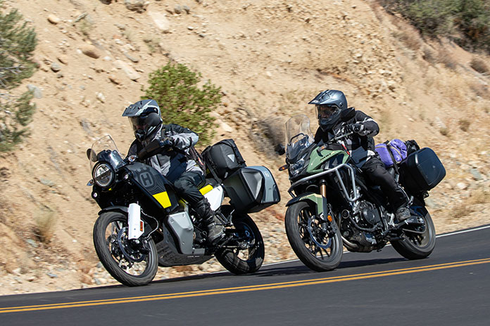
Enjoying fresh pavement on Lockwood Valley Road aboard the Husqvarna Norden 901 and Honda CB500X.
If I’m honest, I’ve never felt like the “talent.” I’m a rider with middling skills who is always trying to compensate for a lifelong habit of cocking my head to the left, inspiring a few riding buddies to nickname me “iLean.” The real talent is the guy behind the camera.
The Dukester
Another industry veteran I’m proud to call my friend is Kevin Duke. He started out at Motorcyclist in the late ’90s and was an editor at Roadracing World and Motorcycle Consumer News before taking the helm as editor-in-chief at Motorcycle-USA.com and then Motorcycle.com. When the EIC position opened up at our sibling publication, Thunder Press (which became American Rider last May), I was stoked when Duke landed the job.
The Honda CB500X is more at home on the pavement, despite its adventure styling and 19-inch front wheel.
Over the years, I’ve attended dozens of press launches around the world with Duke. He was at my first press launch in Gatlinburg, Tennessee, in the spring of 2008, one that will forever live in infamy after one guy crashed (me), nearly every other journalist got a ticket, and one unlucky soul was hauled off in handcuffs. But that’s a longer story best told over a couple of beers…
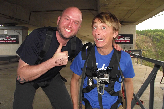
In January 2013, Duke and I attended the global launch of the BMW R 1200 GS “water” Boxer in South Africa, an event that got cut short on the first day after a British motojournalist crashed and ultimately succumbed to his injuries.
Following the fatal incident, the mood at the launch was somber. We had a free day before our flight home, and Duke and I decided we needed to do something life-affirming. So we borrowed a BMW X1 and drove to Bloukrans Bridge, which, at 700 feet above the Bloukrans River, is the site of the world’s highest commercial bungee jump.
Can you tell which one of us had completed the Bloukrans Bridge bungee jump and which one was awaiting his fate?
I was nervous during the entire two-hour drive there, hoping Duke would chicken out so I could do the same. But he never did, and we went through with it. The jump was two seconds of sheer terror followed by one of the most exhilarating experiences of my life.
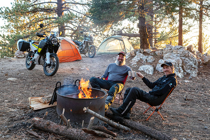
The Motorcycle Camping Plan
Duke and I oversee a small editorial team as we work collaboratively on Rider and American Rider. Duke is a former racer and can wheelie anything on two wheels, but now that he runs an American V-Twin publication, his opportunities to ride bikes not made by Harley or Indian are limited.
“Hey Duke, we’re working on this adventure issue for Rider. How about you take the train up here to Ventura, and we’ll go for a ride? Bring your tent and sleeping bag.”
As a full-sized adventure bike with long-travel suspension, the Husqvarna Norden 901 is well-suited for stand-up riding off-road.
We both spend way too much time riding a desk chair, so he didn’t hesitate to accept my invitation. We had a pair of adventure bikes – a Honda CB500X and a Husqvarna Norden 901 – in the Rider garage, and we’d be joined by Wing on our Yamaha Tracer 9 GT long-termer.
You know what they say about the best-laid plans. Duke missed his 6 a.m. train, pushing our departure back by two hours. Deadlines, a bum knee, and aftereffects of a Covid booster slowed down my last-minute packing, so by the time we hit the road it was noon.
Introduced last year, the Norden 901 is Husqvarna’s first foray into the adventure/travel segment. Husky is owned by KTM, and the Norden is built on the same platform as the KTM 890 Adventure. It’s powered by an 889cc parallel-Twin that makes a claimed 105 hp at the crank, and it has throttle-by-wire, a 6-axis IMU, and a full suite of electronic rider aids. MSRP is $13,999, and the touring cases with carriers add $1,030.
First, the Ride
From my house, I can hit California Route 33 with a rock. It peels off U.S. Route 101 near the beach, and after winding through small hamlets like Casitas Springs and Oak View, Route 33 passes a biker hangout called the Deer Lodge and becomes one of the best motorcycling roads in Southern California, entering the wide-open spaces of Los Padres National Forest. I even wrote about the 33 in my cover letter when I applied to Rider back in 2008:
A motorcycling treasure sits in Rider’s backyard. The triple-crown of the Jacinto Reyes Scenic Byway (Route 33), Lockwood Valley Road, and Cerro Noroeste Road has it all: breathtaking vistas, peg-scraping switchbacks, fast sweepers, and top-gear straights.
In Honda’s lineup since 2013, the CB500X has grown into its role as a light, affordable adventure bike. Built around a 471cc parallel-Twin, in 2019 it got a larger front wheel, more suspension travel, and other upgrades. Updates for 2022 include a lighter front wheel, a lighter swingarm, a new inverted Showa SFF-BP fork, and dual front disc brakes. MSRP is $7,199, and Honda’s accessory tankbag, light bar, and panniers bring the as-tested price to $8,517.
Even better, these roads have minimal traffic, especially on a Tuesday. “The Kevins” and I have ridden together many times, and we enjoy a brisk pace. We pushed our bikes hard and gnawed the chicken strips down to gristle. And then, out of nowhere, we received an unexpected gift.
Covering about 25 desolate miles from its junction with Route 33 to the small community of Lake of the Woods, Lockwood Valley Road has suffered a long history of neglect. It was in rough shape when I first rode it 15 years ago, and over the years, it has only deteriorated further. One tricky section is a tangled knot of first-gear corners that go through narrow desert canyons and washes. On one of my first test rides through Lockwood Valley, I dumped a $20,000 BMW R 1200 HP2 Megamoto in a patch of sand that caught me off-guard, cracking one of the magnesium cylinder heads and nearly putting my dream job at risk.
As the Kevins and I turned onto Lockwood Valley Road, we saw that the top layer of pavement had been scraped off. A few miles later, we came upon the paving crew. And then … nirvana!
The recently repaved Lockwood Valley Road was a delight.
All the twists and turns that were such a challenge when the pavement was cracked, patched, potholed, and strewn with sand and rock-slide debris became a jet black, eerily smooth roller coaster like those plastic Hot Wheels tracks you could twist into acrobatic shapes and loops. We were gobsmacked.
The Actual Motorcycle Camping
An army marches on its stomach, and so does a crew on a photoshoot ride. We’re all remote workers these days, so rides like these give us a chance to see each other face-to-face and have some laughs. While we sat around a picnic table and scarfed down an XL combination pie at Mike’s Pizza, Duke revealed that Wing had also been the photographer on his first shoot – 25 years ago to the month. We commiserated about the recent heat wave, inquired about Duke’s and Wing’s kids, and discussed the length of my beard. By December, I should be eligible for a part-time gig as Santa.
As California Route 33 follows the winding path of the Ventura River through Wheeler Gorge, it passes through a pair of tunnels built in 1931.
We waddled out to the bikes rubbing our distended bellies, saddled up, and made our way through the alpine community of Pine Mountain Club before spiraling our way up Cerro Noroeste Road to the top of its namesake mountain. Cerro Noroeste is surrounded by the Chumash Wilderness, and sprawled across its 8,300-foot summit under the shade of enormous Jeffrey pines is Campo Alto Campground.
When my brother and I first camped at Campo Alto back in ’06, we had embraced our Tennessee heritage, bringing little more than a box of fried chicken, a bottle of Jack Daniel’s, and bed rolls tossed in the bed of my F-150. We’ve taken Rider staff camping trips to Campo Alto, so it seemed a fitting location for our most recent escape. A week after Labor Day on a Tuesday, it was deserted.
Shaded by enormous Jeffrey pines, Campo Alto Campground is perched atop Cerro Noroeste at 8,300 feet in Los Padres National Forest.
As the Kevins set up camp, I rode down to the general store in Pine Mountain Club and stocked up on beer, chips, sandwich fixin’s, and firewood. We soon had a toasty blaze going and cold cans of IPA in our hands. Heavy rains had spun off from Cyclone Kay and soaked the mountains only a day or two before, and the petrichor mixed with the smell of pine and wood smoke.
“Hard to believe we’re so close to home,” Wing said. “Feels like we’re a million miles away.”
We had ridden less than 100 miles since leaving Ventura, and it was probably half that to the campground as the crow flies. But we were on the top of a mountain surrounded by wilderness, and there was no one around but us.
“Trust me, Duke, if we just bomb down this hill, go over the river, and through the woods, we’ll get home an hour earlier.”
After the sun went down, it dropped into the 40s, so we huddled close to the fire, sipped some 10-year-old Henry McKenna bourbon, and told war stories about press launches, photoshoots, close calls, and embarrassing moments. (Yes, I told the Gatlinburg story.)
Ours was an adventure with a little “a.” We didn’t do much preparation or planning, nothing went wrong, and we were back home in less than 36 hours. But we slept in tents under the stars, had fun, and asked, “Why don’t we do this more often?” Even a brief escape with good friends does wonders for the soul.
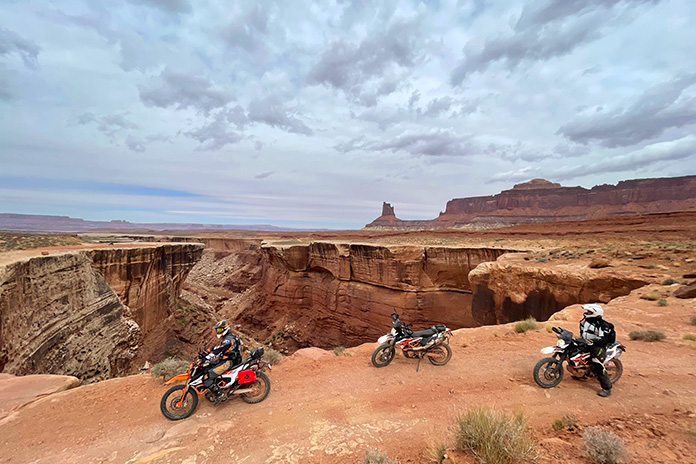
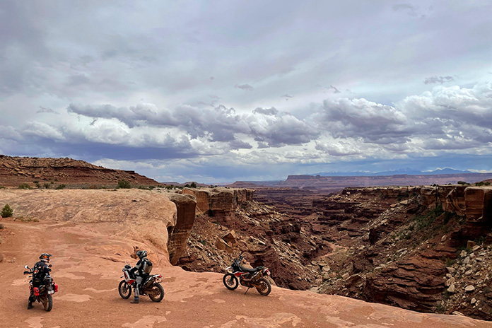
Taking a break at Hurrah Pass during our warm-up ride on Chicken Corners Trail.
White Rim Trail – or White Rim Road in national park parlance – is a 100-mile unpaved route that loops around the Island in the Sky mesa in Canyonlands National Park near Moab, Utah. It’s on the bucket list of many dual-sport and adventure riders, and rightfully so. The scenery is spectacular, and the trail is ridable by anyone with a modicum of off-road experience.
White Rim Trail, named after the layer of White Rim Sandstone that it runs on top of, was built in the 1950s by the Atomic Energy Commission to access uranium deposits. The mines didn’t produce much ore and were abandoned, and the road became part of Canyonlands after it was established in 1964.
Although White Rim Trail is a rough and rugged route, only street-legal (plated) motorcycles and high-clearance, four-wheel drive vehicles are permitted. Off-road-only dirtbikes, ATVs, and side-by-sides that are common on many trails around Moab are prohibited, which helps keep noise and traffic down. There’s also a daily limit of 50 day-use permits.
Since the trail is within Canyonlands, a national parks pass or entrance fee ($25 per motorcycle, good for seven days) is required. Day-use permits are free at visitor centers, but a $6 fee is required for permits purchased online at Recreation.gov. There are several campgrounds along the trail that require overnight permits for an additional fee. In the spring and fall, reservations are strongly encouraged.
White Rim Trail runs atop a layer of White Rim Sandstone below the Island in the Sky mesa.
The plan was for four of us – Bruce Gillies, Vic Anderson, Kevin Rose, and me – to ride the entire White Rim Trail in one day. We would be traveling light, with all of us riding KTM 690 Enduro Rs. As enjoyable as camping would be in such a beautiful place, it requires gear that would’ve weighed us down, and whatever was in our saddlebags or panniers would be subjected to paint-shaker conditions for hours on end. Instead, we rented a house in Moab that served as our base for two days of riding.
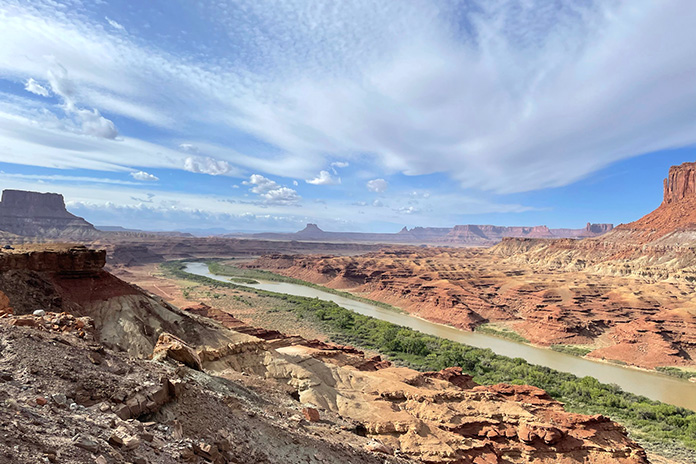
As a warm-up for the White Rim, we spent our first day riding Chicken Corners Trail, a 42-mile out-and-back route on Bureau of Land Management land that passes through Kane Springs Canyon, goes over Hurrah Pass, and runs along a high sandstone bench on the southern edge of the Colorado River. We got hammered by rain early on, but then the clouds parted, and we enjoyed a fun, scenic ride. The trail ends 400 feet above the river across from Dead Horse Point Overlook, the filming location for the final scene in Thelma and Louise when they drive off the cliff.
Hidden from view near the patch of green is the Colorado River, which joins with the Green River below the southern tip of White Rim Trail.
Having obtained our day-use permits online, the next day we left the house around sunrise and rode north on U.S. Route 191 past Arches National Park and then turned west on State Route 313. There’s no gas in Canyonlands, and the nearest gas station is about 30 miles away in Moab, so completing the loop requires at least 160 miles of range. We were equipped with auxiliary fuel canisters just in case.
White Rim Trail is a two-way road, so it can be ridden in either direction. Our plan was to ride it counterclockwise, saving the famous Shafer Trail for the very end. We turned west on Mineral Canyon Road (BLM 129) before entering Canyonlands and followed the long, flat, well-graded dirt road for about 12 miles.
When ridden counterclockwise, White Rim Trail passes through Bureau of Land Management land before entering Canyonlands National Park.
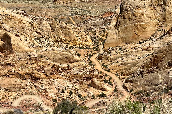
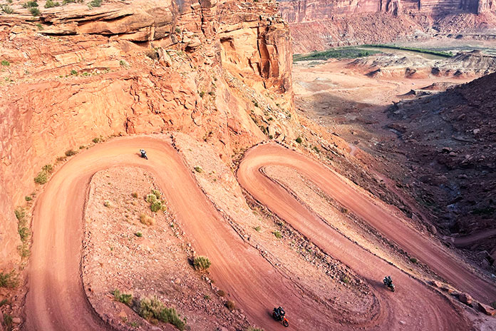
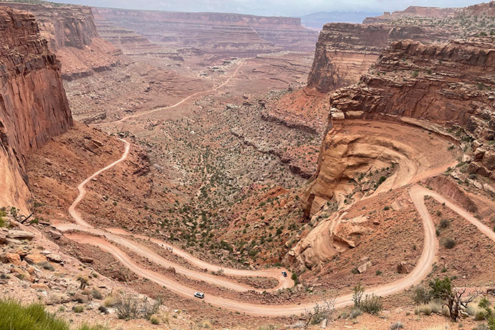
The road into Canyonlands climbs up onto the Island in the Sky mesa, which is where the visitor center and many RV-clogged overlooks are located. Since the White Rim is below the mesa, riding it in either direction requires going down a series of steep switchbacks to get to the trail.
Getting to White Rim Trail from atop the Island in the Sky mesa requires a steep, switchbacked descent to the rim and then a similar ascent at the end.
On a crisp morning in late May, we peered down into the red sandstone canyon carved by the Green River and descended to Horsethief Bottom. After passing the Canyonlands National Park boundary sign, we cruised along the flat trail and took in the full spectrum of colorful scenery: green vegetation along the river; layers of red, pink, yellow, white, and gray rock; and blue skies sprayed with tufts of white cirrocumulus clouds. Off in the distance was Canyonlands’ Maze district.
Riding along the Green River, with Canyonlands’ Maze district off in the distance.
Our first challenge was crossing a sand wash where Upheaval Canyon dumps into the Green River. If the Green is running high, the wash can be flooded and make the trail impassable. We blasted through on the gas and soon found ourselves at one of the two most technical sections on the trail: Hardscrabble Bottom. Since we rode the loop counterclockwise, this section was downhill, and we picked our way along without incident.
Even though it was a Saturday, we rarely saw others on the trail. We waved to a group of Jeepers at a campground, and we passed a few 4x4s and mountain bikers followed by support trucks. Otherwise, it was just the four of us enjoying the sweeping views and a fun trail with minimal dust thanks to the previous day’s rains.
Box canyons, hoodoos, buttes, and spires are common sights in the eroded landscape of Canyonlands National Park.
The second technical challenge on White Rim Trail is climbing up and over Murphy’s Hogback. Our KTMs were perfectly suited for the terrain, and we again made it through without any problems. Bigger ADV bikes would be more of a handful here but certainly capable of getting through.
While some of White Rim Trail is red dirt and sand, miles of it are on bare sandstone, which makes for a bumpy ride. Long-travel suspension, good ground clearance, and a sturdy skid plate are essential.
Pausing to admire the view. Parts of White Rim Trail run right along the cliff’s edge, and there’s no fence or guardrail.
The sky had become progressively cloudier throughout the day, and by midafternoon, dark clouds blotted out the sun. At the junction with Potash Road, a ranger checked our permits before we began the final climb up the Shafer Trail switchbacks. This section of trail is accessible by anyone visiting Canyonlands, so we worked our way to the top around not only Jeeps and mountain bikes but Toyota Camrys full of Instagrammers too.
The switchbacks of Shafer Trail marked the end of our White Rim ride.
A few fat raindrops began to fall as we exited the trail. We made a hasty retreat back to the house to hoist celebratory beers and share stories about our adventure.
Heading into the clouds of the Beartooth Pass south of Red Lodge, Montana. Photos by Marilyn Rich.
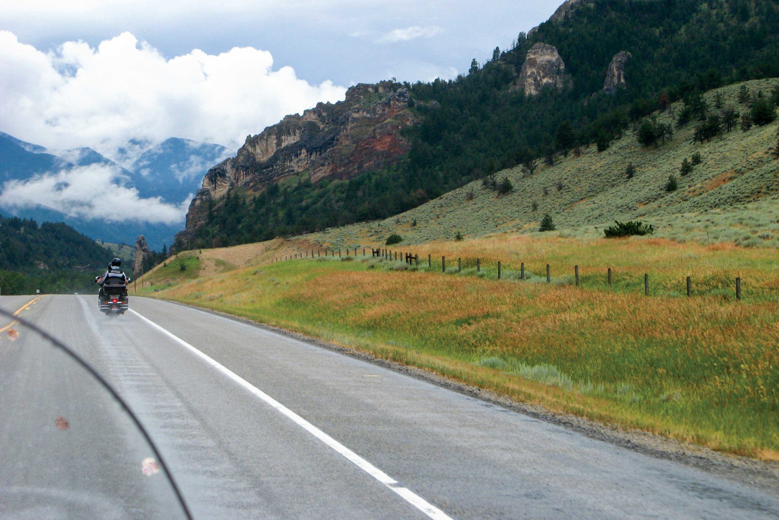
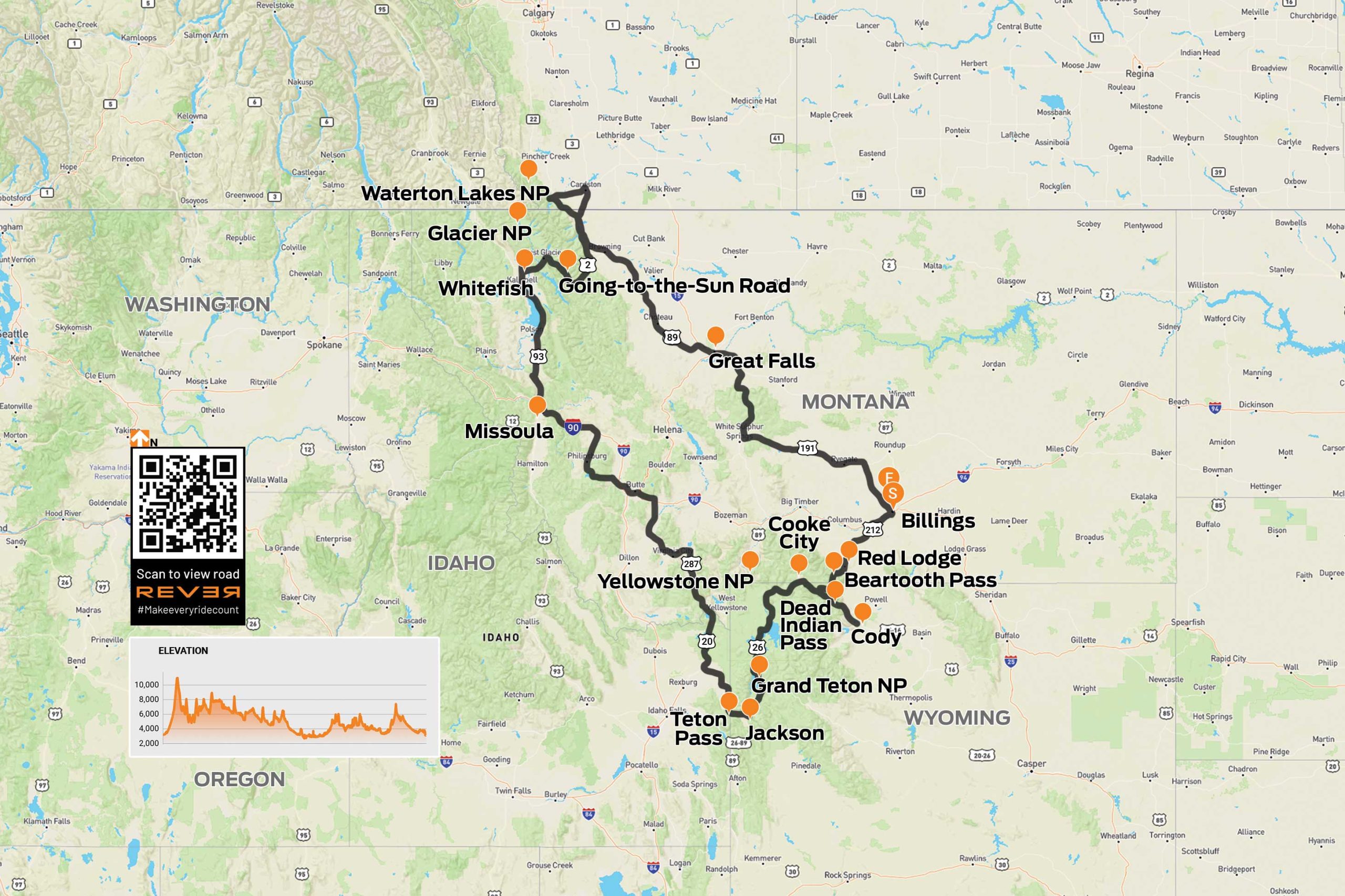
Hell yes! That is the only plausible answer when friends invite you to join them on an eight-day motorcycle ride through the mountains of Montana (including the legendary Beartooth Pass), Wyoming, Idaho, and Alberta, Canada.
We start our ride in Billings, Montana, on a pair of Harley-Davidson Electra Glide Classics rented from EagleRider, and head south to Laurel, where we pick up U.S. Route 212. We continue south to Red Lodge, where the road becomes Beartooth Highway and crosses into Wyoming on its way up to Beartooth Pass (10,947 ft). This is one of the best motorcycling roads in America, and it is easy to see why, even in the rain.
West of the pass, we turn south on Wyoming Route 296, which is also known as the Chief Joseph Scenic Byway. The byway has great sweepers as well as picturesque views of the Absaroka Mountains as it climbs up and over Dead Indian Pass (8,071 ft).
Looking down on the Chief Joseph Scenic Byway.
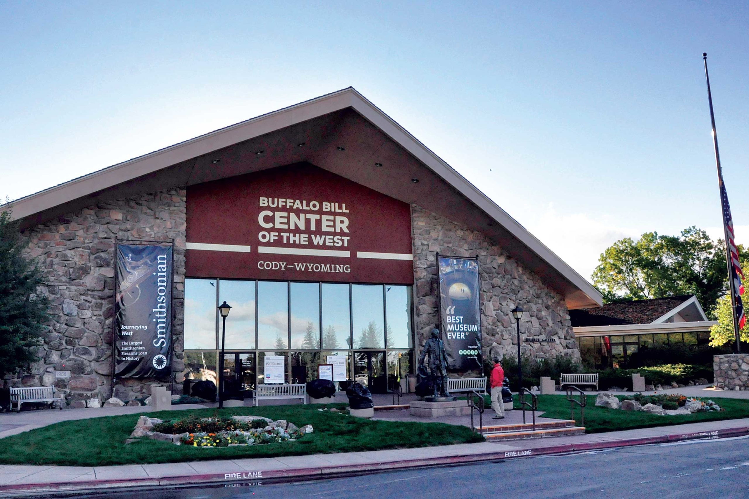
We arrive in Cody in time to tour the Buffalo Bill Center of the West, a superb display of life in the Old West. The center has five museums: the Buffalo Bill Museum, which is about his life and times; the Plains Indian Museum, which showcases art and heritage; the Draper Natural History Museum, highlighting the ecosystems of Yellowstone; the Whitney Western Art Museum; and the Cody Firearms Museum.
The Buffalo Bill Center of the West in Cody, Wyoming.
We awake to a light rain that lingers until we head into the mountains west of Cody, and then the heavens open up with what my granddad used to refer to as “a real frog-strangler.” Looking over and around the windshield, I am barely able to make out the taillight of the bike in front of me, and I have no idea how he manages to follow the road on our way back to Beartooth Highway. The clouds part as we ride into Cooke City, Montana, a Wild West town where motorcycles have replaced horses at the hitching posts.
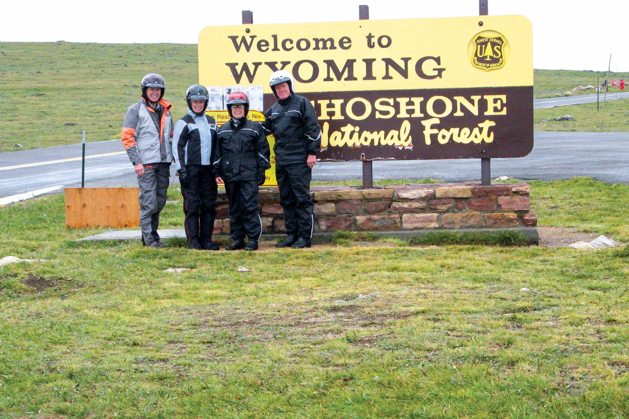
Crossing into Wyoming on the way to Beartooth Pass.
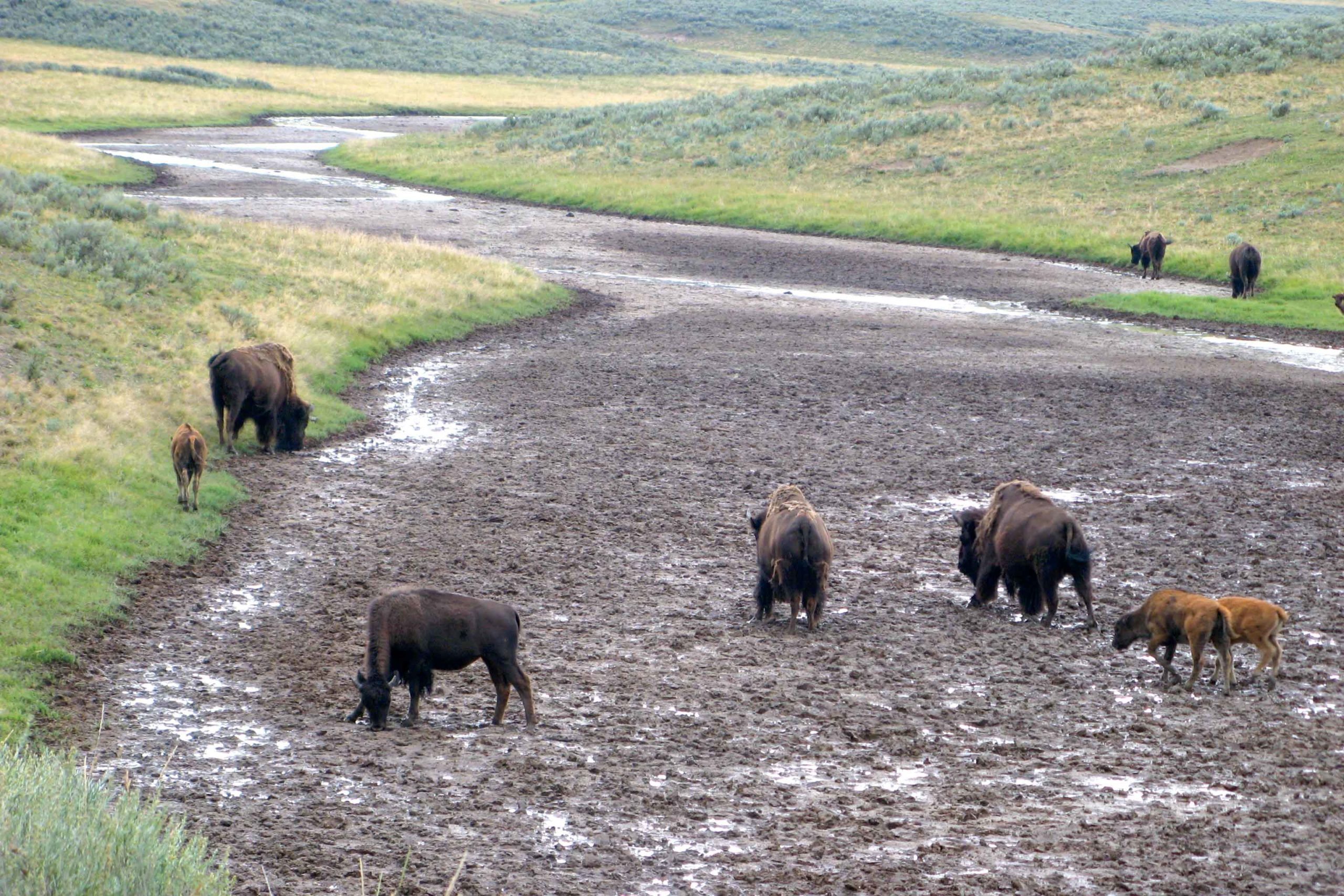
Our adventurous ride through Yellowstone National Park and Grand Teton National Park includes a wide variety of wildlife; a large RV that decides to stop, unannounced, in the middle of the road to take some pictures; and a herd of bison that crosses the highway one or two at a time, backing up traffic for a mile. When our turn comes to run the bison gauntlet, an exceptionally large bull gets ready to cross the road. We are directly behind a pickup truck, so I suggest to our riding partners that when the truck starts to move, we should stay close to its rear bumper so it looks like we’re being towed.
Buffalo looking for water in the parched Yellowstone River.
After spending the night in Jackson, Wyoming, we ride west on State Route 22 over Teton Pass (8,432 ft) and into Idaho. The winding roads, the views of the Tetons to the east, and crossing rivers with trout fisherman in waders fly casting made for a fun, scenic ride. We continue north on a stretch of U.S. Route 20 known as Mesa Falls Scenic Byway.
We cross back into Montana and end our day in Butte, once a wealthy copper mining town and more recently home to the late Evel Knievel, the legendary motorcycle daredevil. In the morning, we ride through downtown to view the mansions that signify a bygone era, and then head west through mining country. It’s Saturday morning and we are getting low on gas, so we stop in the tiny town of Phillipsburg to fill up. The gas station also serves as a general store, a casino, and a bar, all of which have numerous customers.
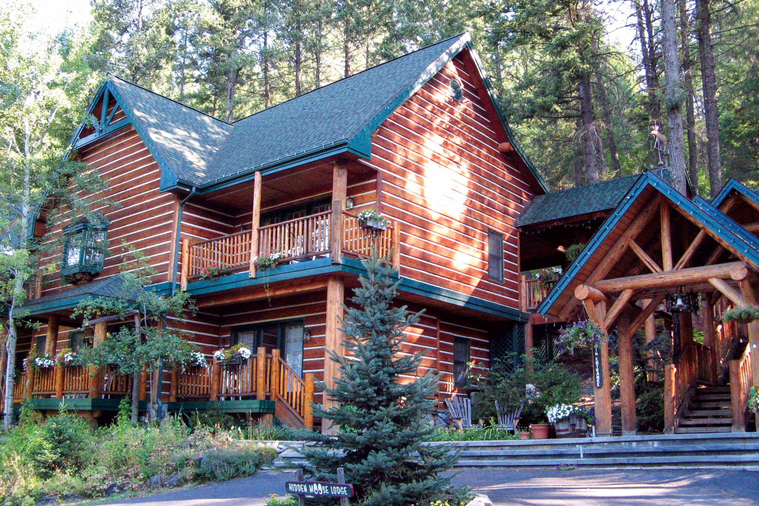
The Hidden Moose Lodge in Whitefish, Montana.
We turn north from Missoula in 100-degree temperatures, finally gaining some relief along the shady roads on the eastern shores of Flathead Lake. Heading back west across the top of the lake, we encounter the largest flock of eagles we have ever seen.
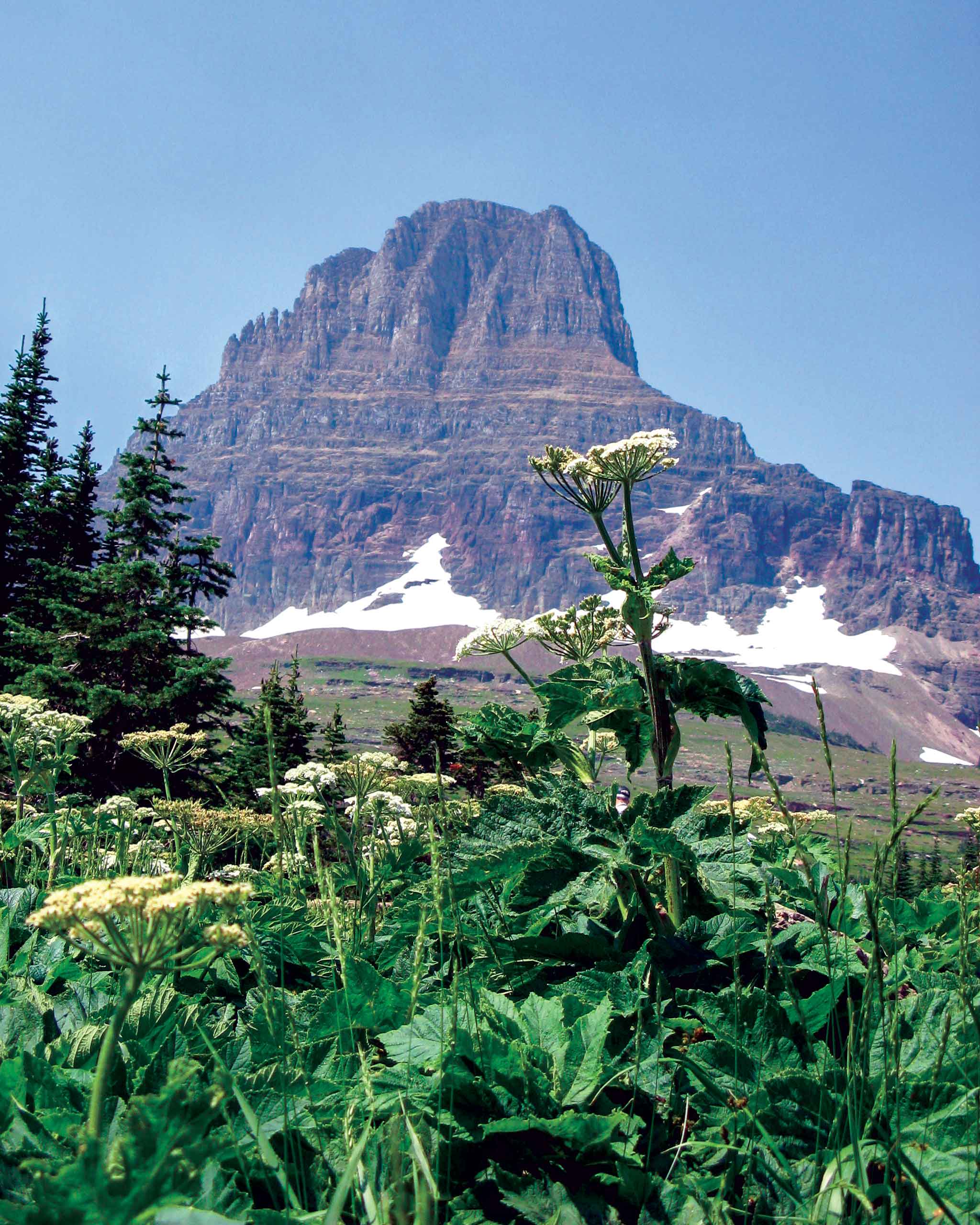
Going-to-the-Sun Mountain in Glacier National Park.
We spend the night at the Hidden Moose Lodge in Whitefish, an exquisite place that serves a gourmet breakfast every morning. With full bellies, the bike feels noticeably heavier as we climb Going-to-the-Sun Road through Glacier National Park, one of the few roads that can give Beartooth Highway a run for its money. We venture across into Alberta, Canada, and visit Waterton Lakes National Park, which is the northern part of the Waterton-Glacier International Peace Park.
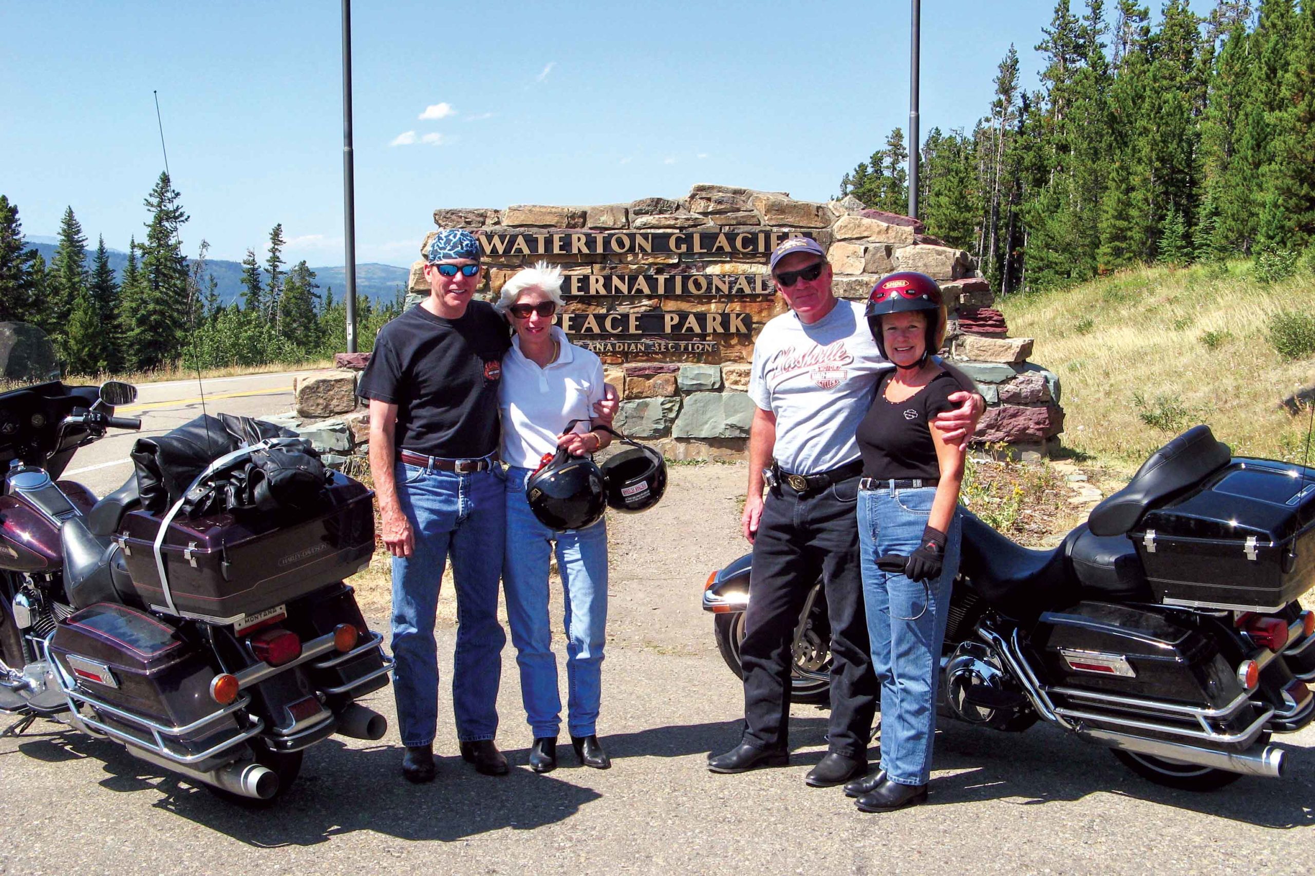
Entering Alberta, Canada, at Waterton-Glacier International Peace Park.
Being from the flatlands of Florida, we’re overwhelmed by the endless peaks and scenery of the Rocky Mountains. We stay at the quaint Kilmorey Lodge, overlooking the Emerald Bay of Waterton Lakes. Relaxing by the gazebo with a refreshing beverage, we’re joined by countless white-tailed deer that consume any vegetation not covered in chicken wire.
Heading south the next morning takes us back across the border through the towns of St. Mary and Browning in northern Montana. A sign on the outskirts of Browning warns of strong crosswinds, but there’s nothing more than a gentle breeze. Ten miles farther south on U.S. Route 89, the breeze becomes a 60-mph crosswind that we battle with for the better part of 40 miles.
At Pine Creek Pass in Idaho.
The town of Dupuyer, Montana, has a population of 93 and no general store or gas station, but it does have two bars. We opt for the Ranch House of Dupuyer for lunch and are pleasantly surprised when the owner/bartender/chef cooks up a superb pulled pork dish. It’s served by his children, ages four and seven, who provide better service than waiters at many fancy restaurants.
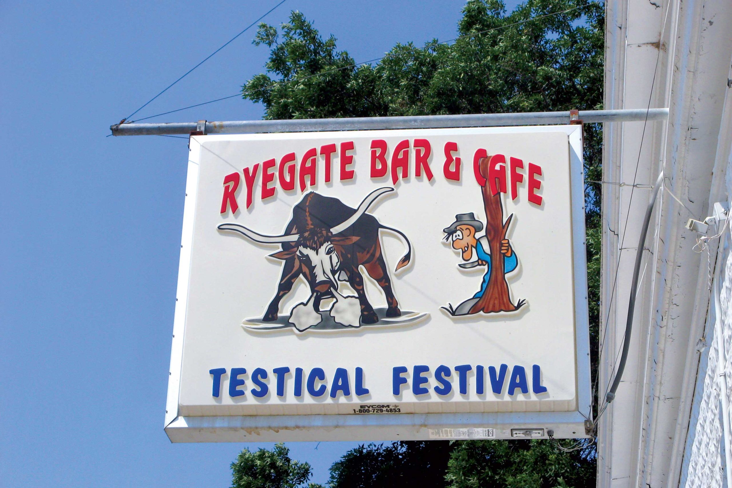
After riding through the haze of wildfire smoke, we stay overnight in Great Falls. The final leg of our journey takes us across the flatlands to the small town of Ryegate, where we are disappointed to discover we’ve missed the annual Testicle Festival.
Lunch stop at the Ryegate Bar & Cafe in Ryegate, Montana.
We arrive back in Billings and return the Harleys to EagleRider. Over eight days and 1,500+ miles, I can say that there was not a single road that I would not ride again in a heartbeat. Great roads, beautiful country.
The Rocky Mountain Front Range is a rider’s paradise. Photos by the author.
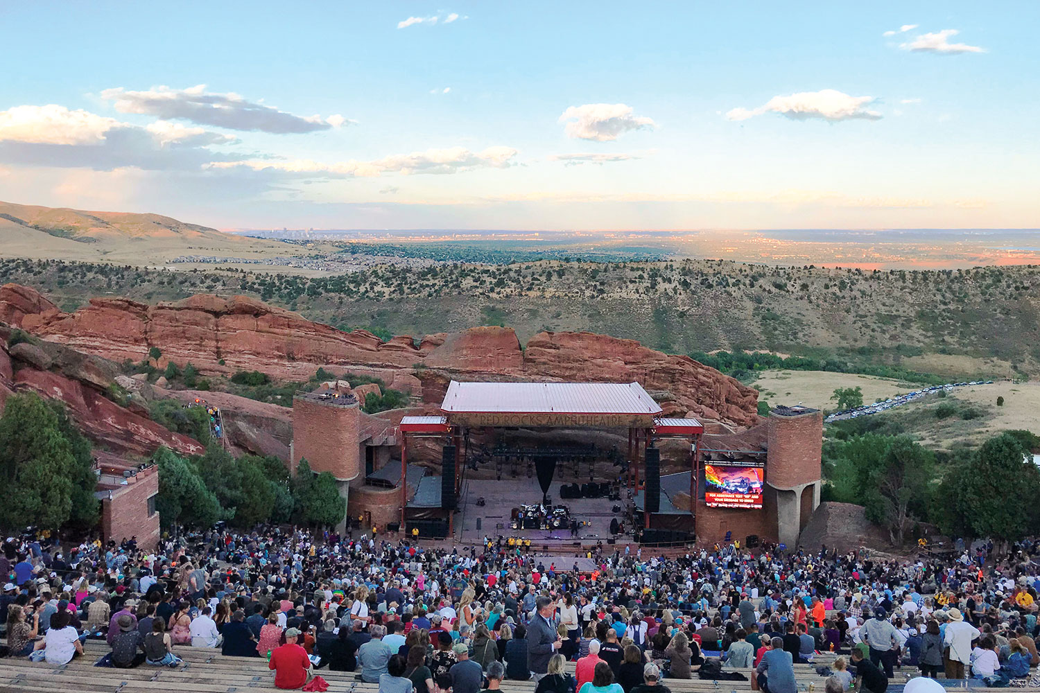
As we sat in the crimson hue of the Colorado Front Range sunset, the stone walls of the iconic Red Rocks Amphitheatre echoed with familiar lyrics. David Crosby’s face was laced with as many crevices as the surrounding sandstone spires, but his vocals gave no evidence of the octogenarian’s age. As he was joined onstage by Jason Isbell for an incredible version of “Wooden Ships,” the last lines sparked anticipation for the next day’s ride: And it’s a fair wind blowin’ warm out of the south over my shoulder / Guess I’ll set a course and go.
Red Rocks Amphitheatre in Morrison, Colorado, offers amazing views.
The next morning, that course was indeed set. Our route would be a figure-8 exploration of the eastern slope of the Rockies, flanking the Denver urban corridor. As we packed the side boxes on the Yamaha Super Ténéré with water and a few extra clothing layers, that fair wind rustled the leaves in the trees around our vacation rental in Golden. Thumbing the starter, the big parallel-Twin quickly settled into a smooth idle. I shifted into gear, and my wife, Cheryl, and I were off.
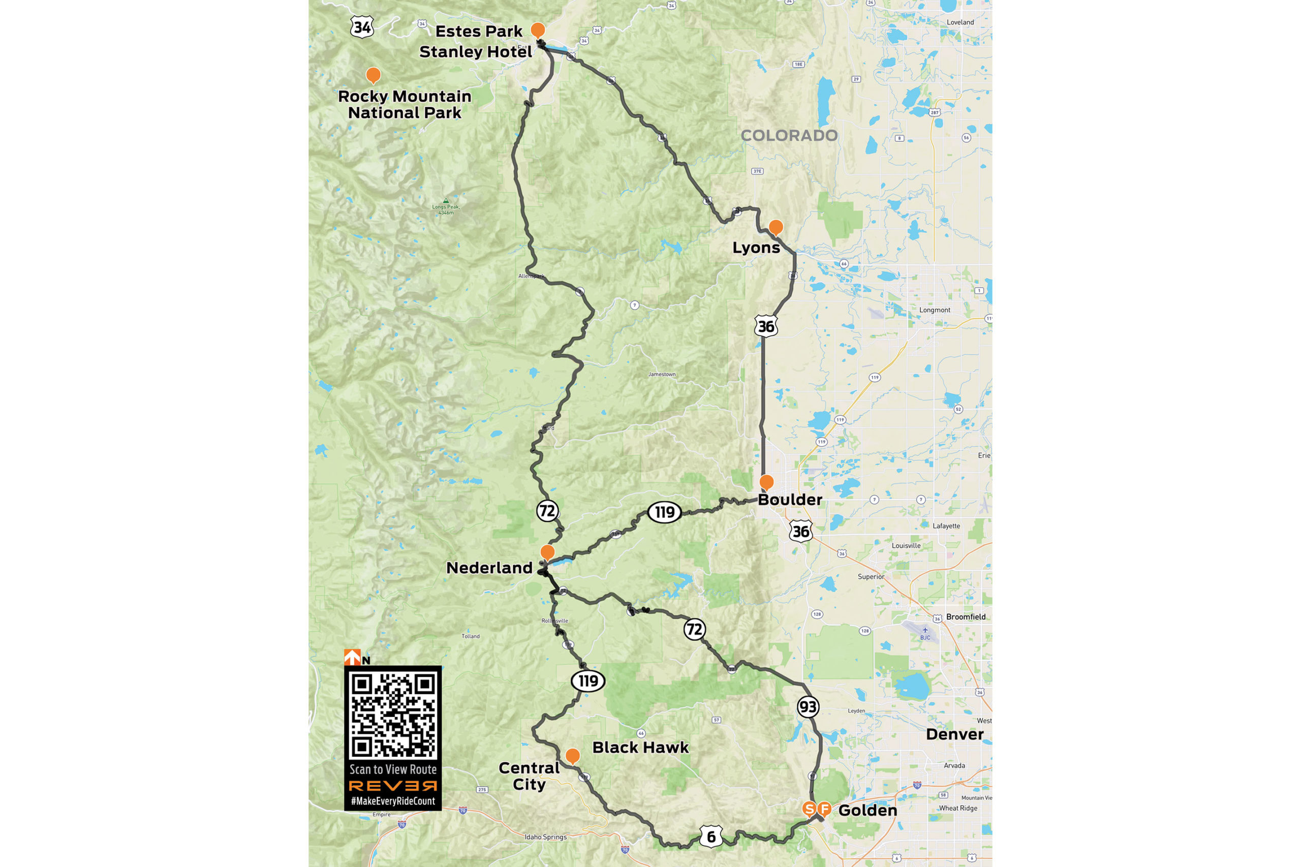
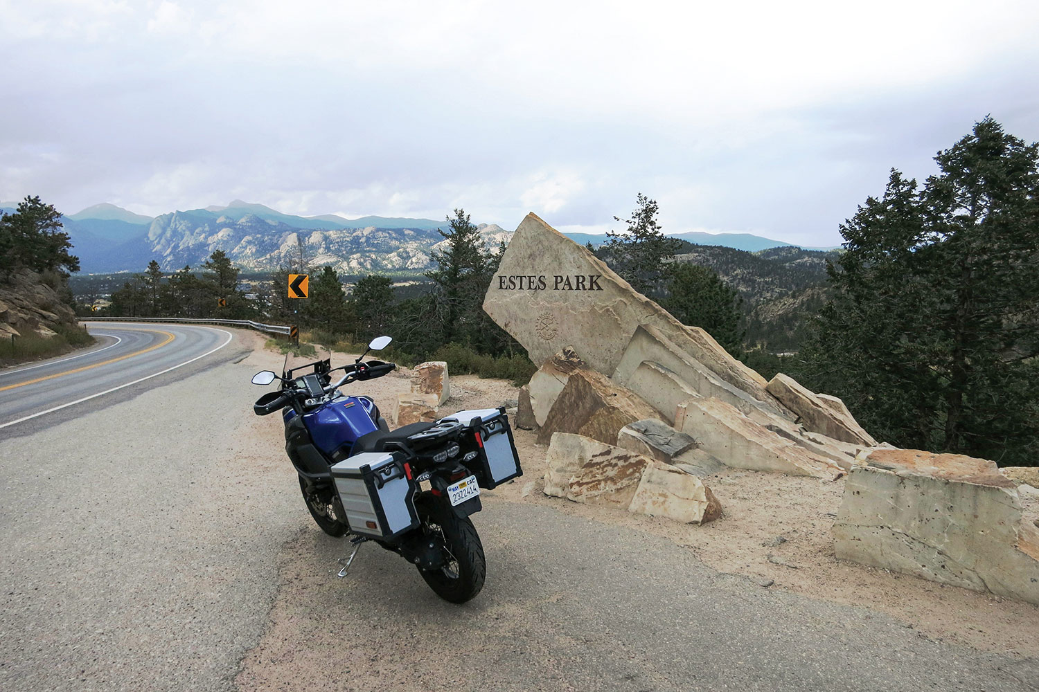
GOLDEN TO ESTES PARK
Figure-8 routes have always intrigued me. It may well go back to my youth watching the insane style of racing at the state fair. Anyway, I mapped a ride leaving Golden to the northwest and tracing that general direction to Estes Park, the northernmost point on our planned ride. The return route would traverse different roads intersecting that path on the way back south.
After a little GPS-assisted navigation out of Golden, Coal Creek Canyon Road (State Route 72) was a relaxed warm up. Wide sweepers cut through treeless grassland at the lower elevation, and with the rise in elevation came a gradual increase in vegetation. Soon, it was clear that this was truly going to be a mountain ride. Near the tiny community of Pinecliffe, the ever-tightening corners coiled into a beautiful series of cliff-lined hairpins at an elevation of 8,000 feet. The fun had really begun.
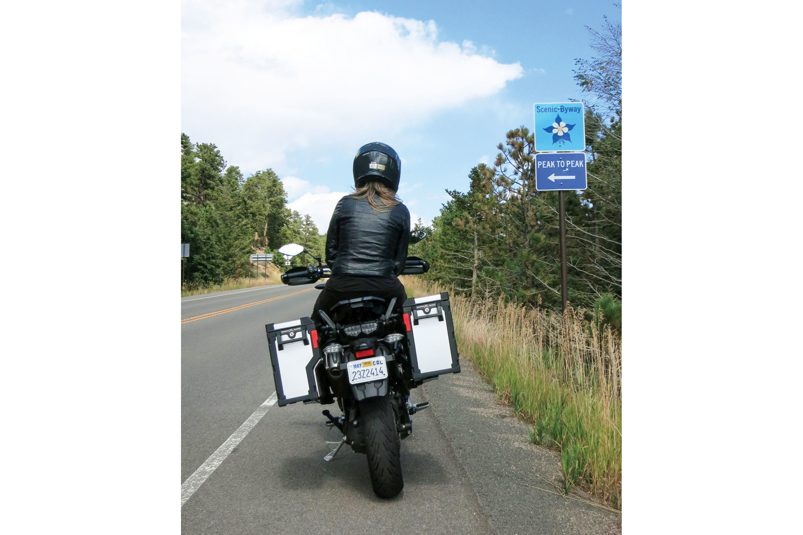
We approached Nederland, which marked the intersection of our figure-8 route. The quaint town is due west of Boulder and sits near the picturesque Barker Meadow Reservoir. After rolling through the town, we resumed our northern trek on the Peak to Peak Scenic Byway (State Route 72). The Peak to Peak is a famous ride in the Front Range of the Rocky Mountains that is considered one of the most beautiful stretches of road in the state.
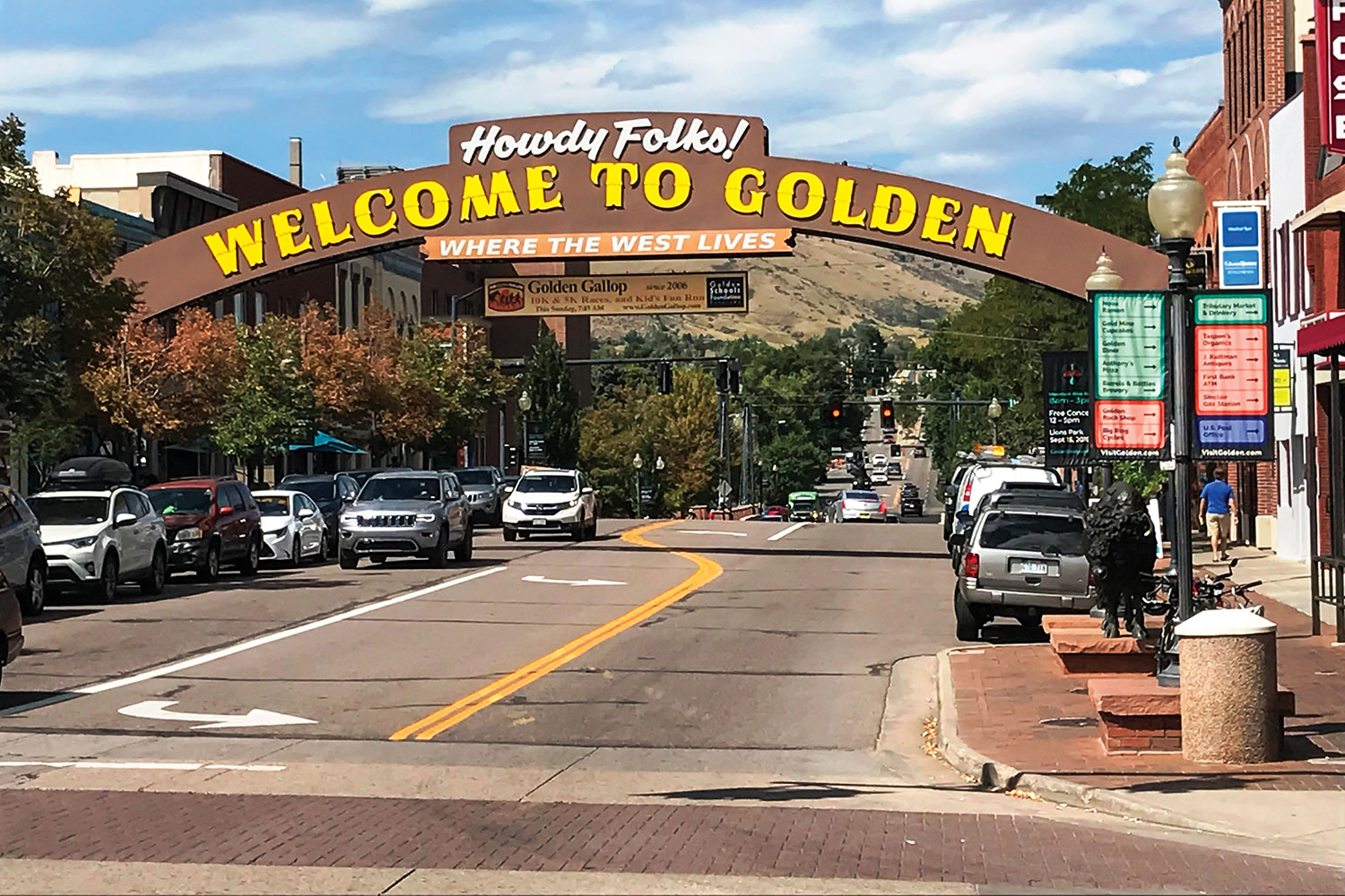
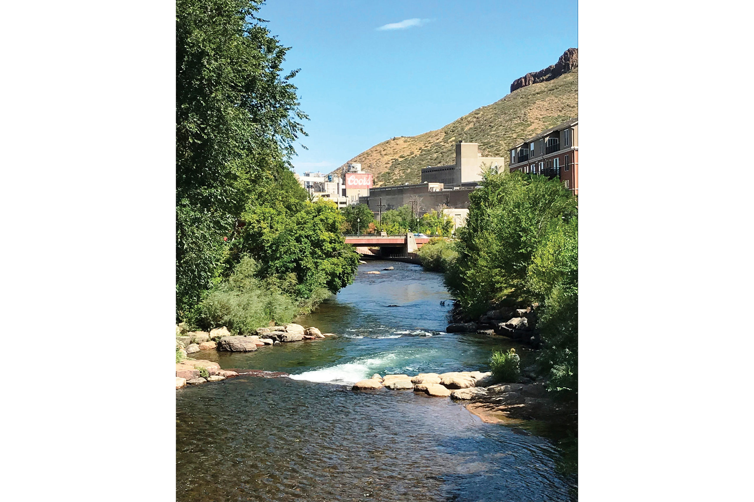
Golden is a bustling Colorado town just west of Denver with a clear emphasis on outdoor adventures. It’s also home to Coors Brewing Company.
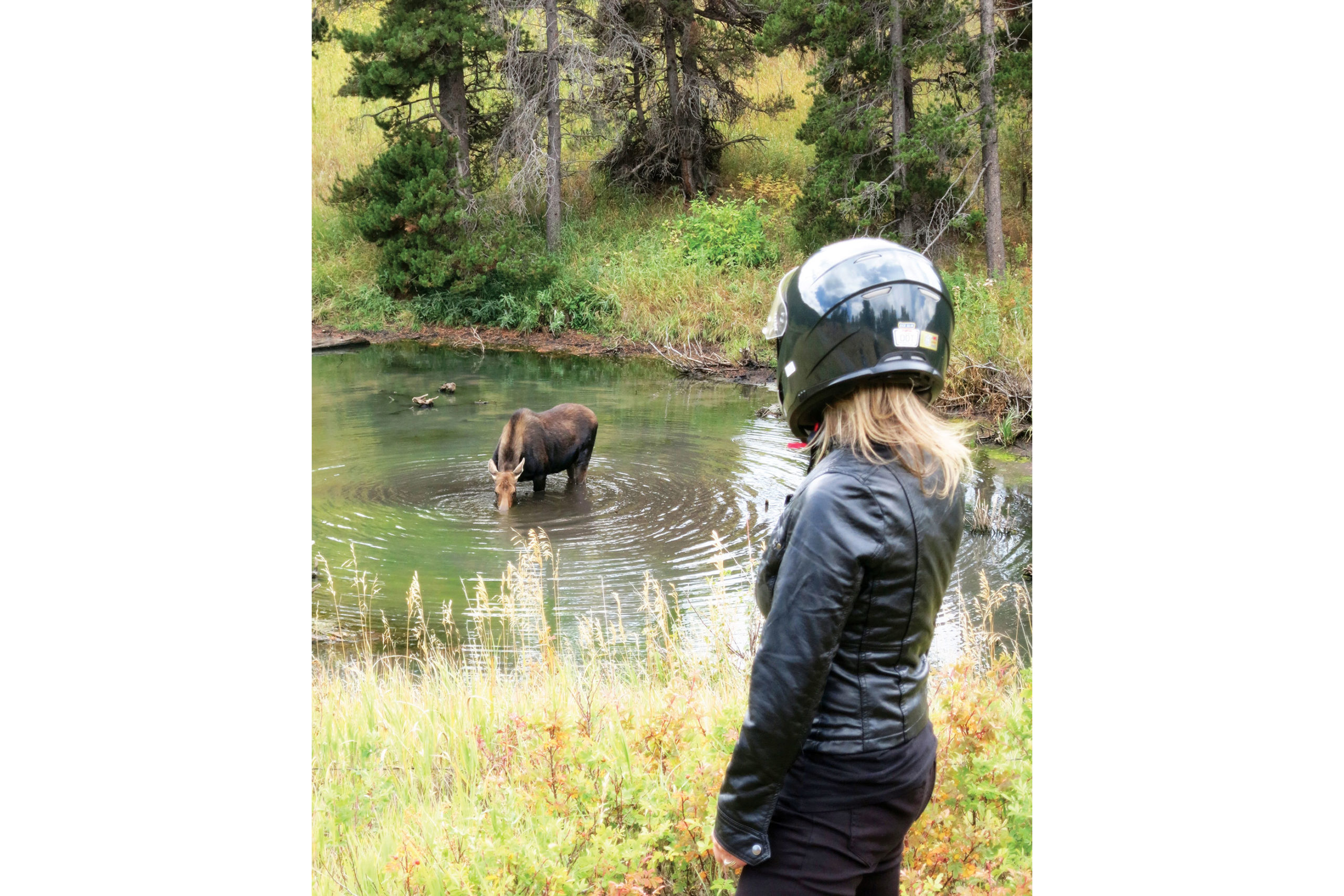
Not a dozen miles into this leg, I spotted something moving in the woods to my right. A moose was standing in the middle of a tiny pond drinking. As we parked the Yamaha and strolled to get a better vantage point, the creature raised its broad, dripping snout and regarded us with supreme disinterest. I did not blame her. After more motorists discovered what we were watching, the shoulder became an impromptu parking lot. It was time to head out.
Cheryl is of no concern to a hydrating moose.
Back on the bike, we continued the curvaceous route on the Peak to Peak toward Estes Park. Intermittent sprinkles met us along the way. There were patches of very wet tarmac, indicating that we had the good fortune of arriving just after a few downpours. It was becoming clear that, despite the rough winters in this region, the road condition was remarkably smooth and consistent.
The Peak to Peak Scenic Byway lived up to its majestic reputation, and every mile was a joy. Mountain peaks flanked the road on both the near and far horizon. The long morning of riding had us more than ready for lunch as we rolled into the outskirts of Estes Park, which is the gateway to Rocky Mountain National Park and was bustling with tourist activity.
Spanning 55 miles from Central City/Black Hawk at the southern end to Estes Park at the northern end, the Peak to Peak Scenic Byway runs through the Front Range and is one of many on the list of great Colorado roads.
We pulled into the first diner we saw. After our patty melts arrived, the owner stopped by for a chat. When we told him about the moose sighting, he was genuinely impressed. He said we were in the middle of the elk rut, so seeing those behemoths butting heads would not be that unusual. However, he said that folks who had lived in the area for years have not seen the elusive moose. We felt uniquely lucky.
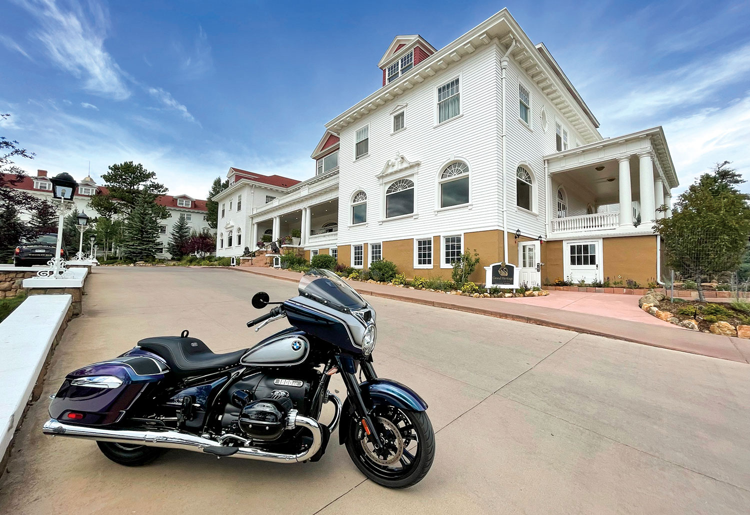
The historic Stanley Hotel in Estes Park is an intriguing place to spend an hour or two or a long weekend.
After finishing our lunch, we made a brief stop at the Stanley Hotel, a stately 140-room Colonial Revival hotel built in 1909. It was the inspiration for the Overlook Hotel in Stephen King’s 1977 novel The Shining and the 1980 film, and it served as a filming location for the 1997 TV miniseries. The Stanley was also the setting for the fictional Danbury Hotel in the 1994 film Dumb and Dumber. You can stay in the hotel, drop in for a tour, or pick up a variety of “REDRUM” souvenirs from the gift shop.
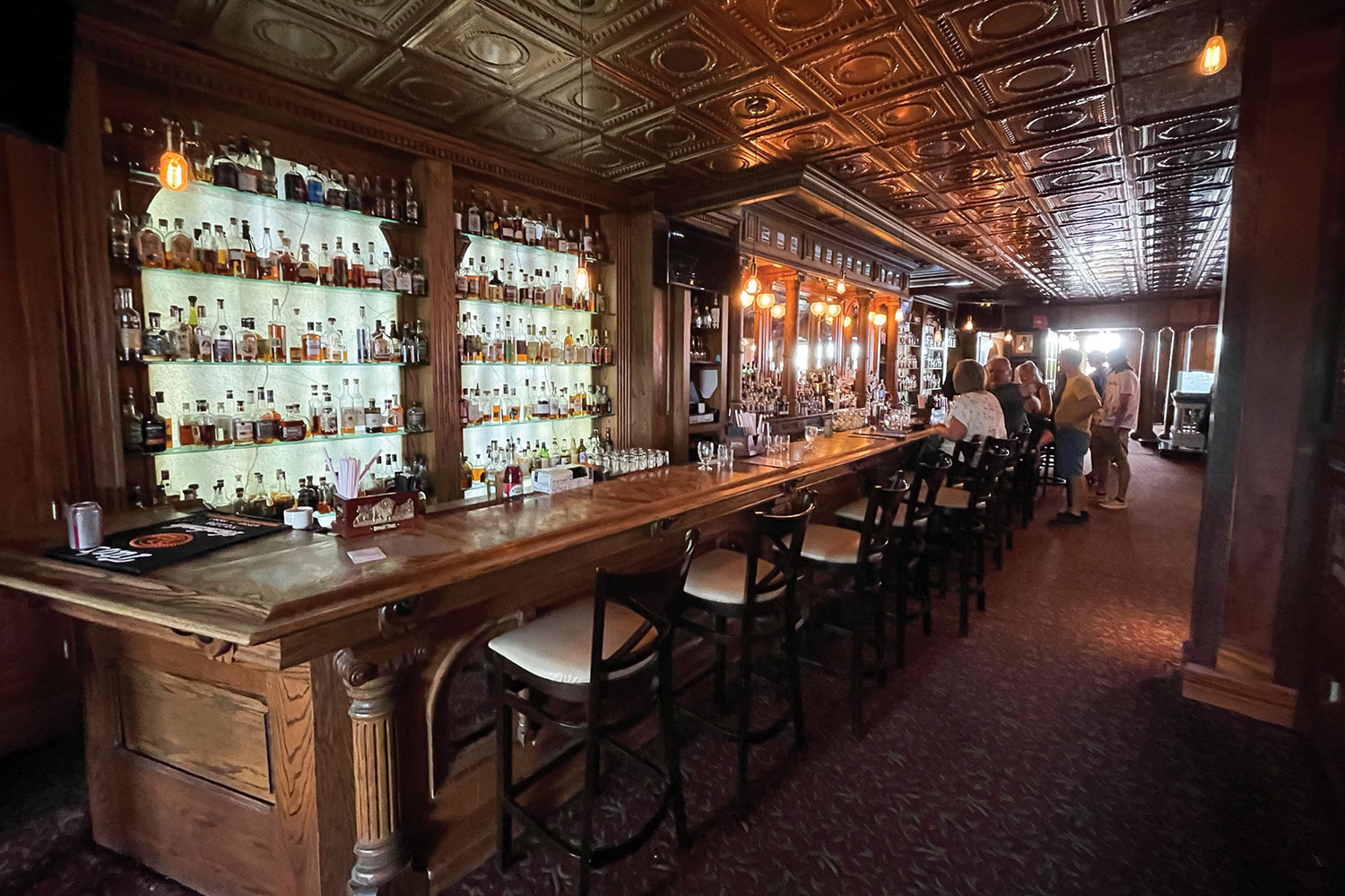
We could have spent the rest of the day in the Stanley’s historic lounge, which has an elegant carved wooden bar, a pressed-tin ceiling, and an impressive selection of whiskeys. But the road was calling, and it was time to finish our figure-8.
The Whiskey Bar & Lounge in the Stanley Hotel.
ESTES PARK TO BLACK HAWK
We rolled southeast out of Estes Park past a few golf courses and lush green hills. U.S. Route 36 proved to be another fantastic motorcycling road in the Front Range. Gray granite outcroppings laced with a variety of conifers lined the winding road. The riding was enjoyably devoid of traffic, and the threat of rain had thankfully subsided.
At the town of Lyons, U.S. 36 started the southern curve back toward the intersection of our figure-8. We were back in the grasslands and rolling hills for several beautiful miles, and then 36 straightened out on its southern line toward Boulder. Of course, the closer to the city that we got, the heavier the traffic became. When the 36 morphed into State Route 7, we were fully in the Boulder suburban area.
An impressive welcome to the gateway to Rocky Mountain National Park.
When we made the western turn onto Boulder Canyon Drive (State Route 119), we were more than ready to climb back into the foothills of the Rockies. When a motorcyclist hears the word “canyon” in a road’s name, it’s like music to ear-plugged ears. Again, the Front Range did not disappoint. The road snaked through tunnels, beside evergreen-lined rivers, and beneath gray rock formations on its route west. It is a truly spectacular motorcycle ride.
When we were approaching the now familiar town of Nederland, we rolled along the banks of the Barker Meadow Reservoir that we previously saw from a distance on the first half of the figure-8. South of Nederland, Route 119 took a decidedly southern bend toward our next planned stop. In our pre-ride mapping, we discovered a pair of historic gold mining towns that have since undergone a metamorphosis as gambling destinations.
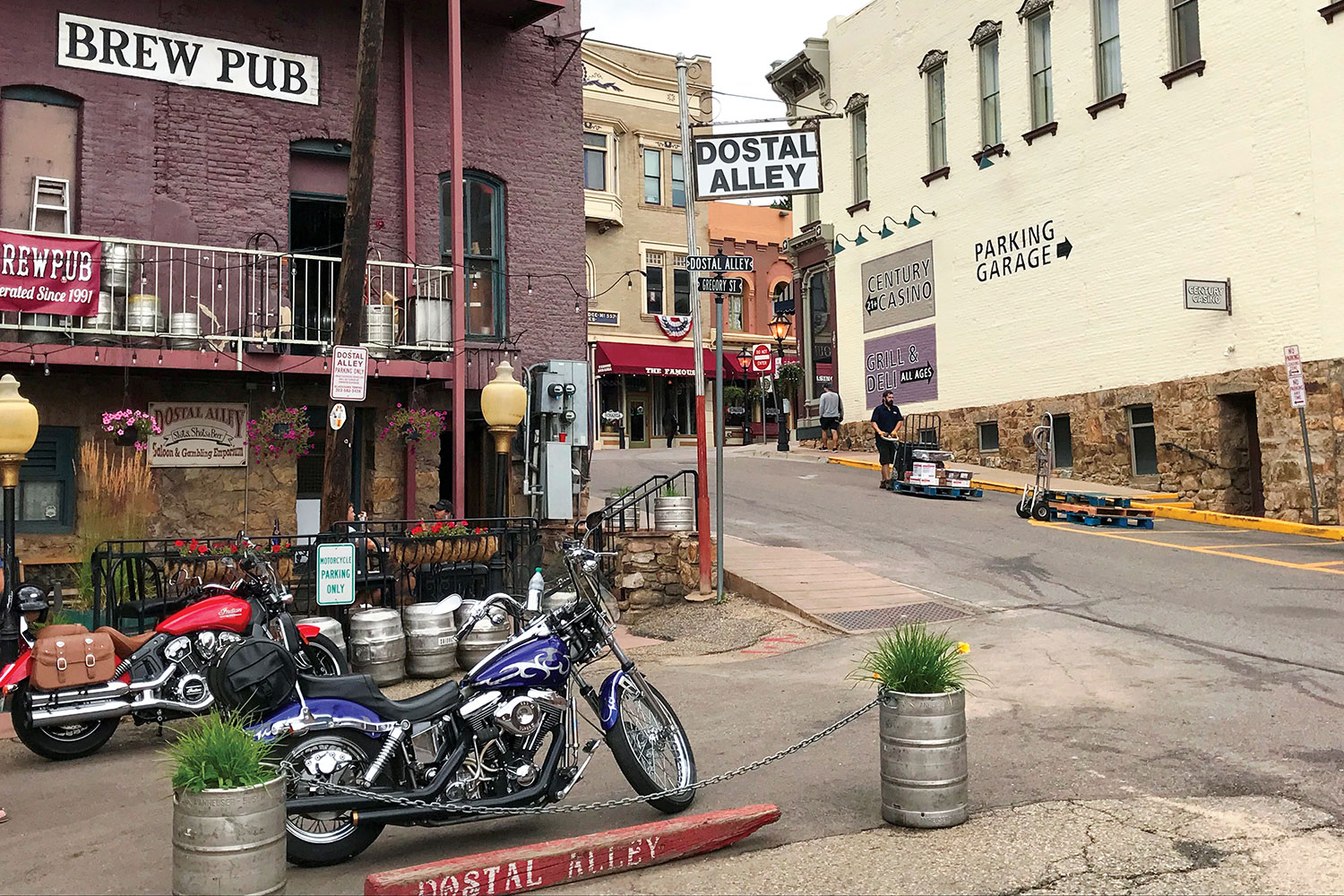
Central City is a well-preserved remnant of the roaring past.
We were greeted in Central City by historic buildings and narrow streets. Saloons, shops, and restored hotels graced the brick architecture. We saw the quaint and colorful history, but not the gambling, and that was just fine with us. We stopped at a brewpub on the town’s main street and had a nice chat with the bartender. The gregarious barkeep graced us with a few painfully corny jokes before answering our myriad questions about the town.
The treasure trove of local knowledge told us that the town of Central City and its close neighbor Black Hawk were hotbeds of the Gold Rush after a huge local gold strike in 1859. Later in the 1800s, the towns were connected to Denver by rail, and the boom continued. However, as they say, all good things must end, and the towns both declined with the dwindling of the mineral wealth in the 1900s.
The Yamaha Super Ténéré proved a worthy mount for the Rocky Mountain ride.
After a few more wonderfully bad jokes, our raconteur brought us to the current state of the area. In the early 1990s, Colorado passed limited-stakes gaming in the state, and the tiny towns picked up on the idea. He said the towns have become the gambling heart of the state, accounting for nearly 90% of Colorado’s gaming revenue. Noticing our quizzical looks after scanning the small smattering of video poker machines and one-armed bandits in the pub, he said with a smile, “Wait until you ride south.”
The merry jokester was prophetic. As we left the quaint ambience of Central City, we rolled through a bit more history before it became clear. High-rise casinos and hotels rose like specters as we rounded a corner. The dichotomy that has been created in this area emerges most distinctly in the town of Black Hawk. Juxtaposed with 150-year-old brick buildings are massive, engineered tributes to modern man’s lust for a quick buck. The irony is more than evident. Gone are the starry-eyed miners, only to be replaced by glassy-eyed gamblers.
Clear Creek flows through Golden and is a magnet for anglers and water sports enthusiasts. The label of Coors beer says “Brewed with 100% Rocky Mountain Water,” and this creek is its source.
We motored out of the unlikely Rocky Mountain “Vegas” and back toward our starting point. The last portion of the ride was a great mix of all that we had experienced on the figure-8 ride into the Front Range. The road was smooth and well maintained, and the scenery was spectacular. We dropped from thick forest, to grassland, to the bustle of Golden.
While not a full exploration of the Colorado Rockies, our tour was a nice overview of the roads and ecosystems of the area. The 40-degree swing in temperatures and the varied precipitation on the ride made it clear that gear choice and preparedness is vital in the Rockies. Because of the elevation, this is strictly a late spring to early fall ride. That said, we would love to return for the spring bloom or the fall leaves to explore the Front Range further.