Tag Archives: Great Roads Northeast

Chasing Gene and Washie: An Indian Tale

Chasing Gene and Washie
Eric Trow and Ron Washabaugh face off on the same clay their grandfathers raced on more than 70 years earlier (below). Contemporary photos by Hal Deily, archival photos courtesy of the author.
Chasing Gene and Washie

At a time when American riders were fighting the Harley and Indian wars, Gene Townsend and Floyd “Washie” Washabaugh were unflinchingly Indian men. It was rumored their blood flowed a bit more maroon than the rest of us, having the distinct deep shade of the brand’s signature Indian Red color.

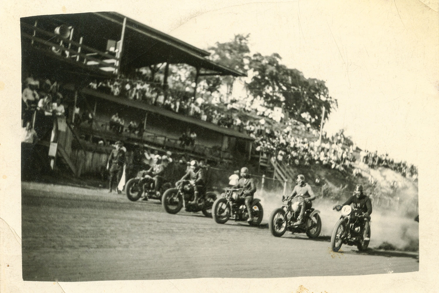
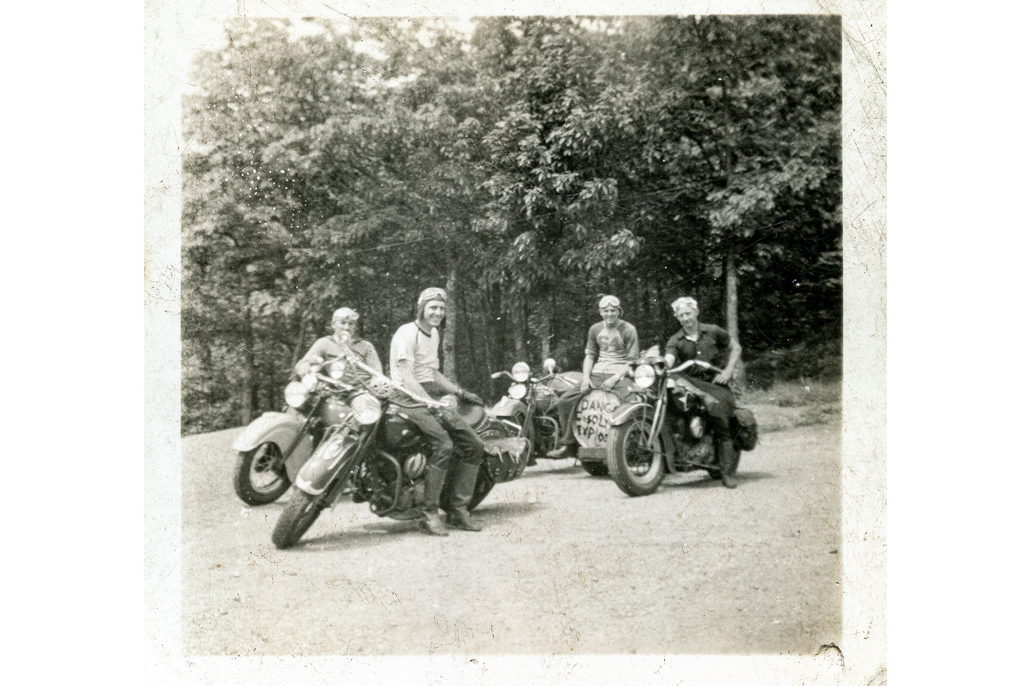
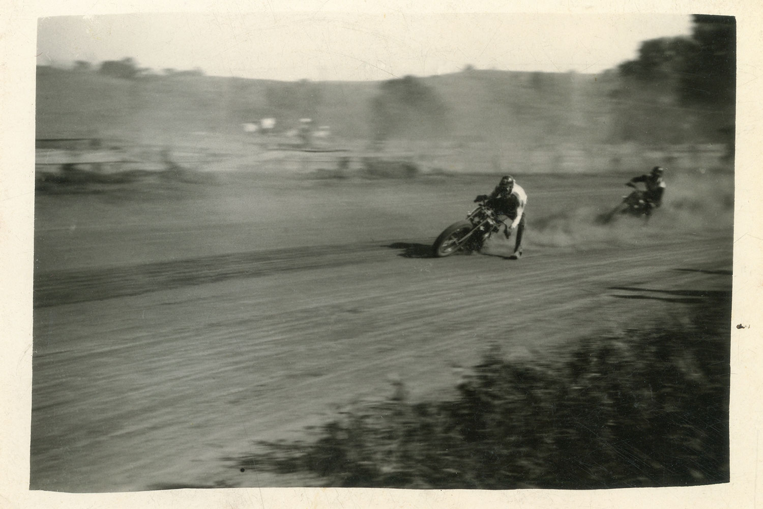
Over the years, the two men defended the Indian brand on dirt tracks across Pennsylvania, Maryland, and Virginia. Gene, my grandfather, born in 1908, spent most of his racing years on an Indian 101 Scout sporting the #9 plate. He was a top regional amateur racer from the mid-1920s on into the war years, only to retire when a brush with a #6 bike sent them both through a fence.

Chasing Gene and Washie
Gene Townsend before a race on his highly tuned Indian 101 Scout.

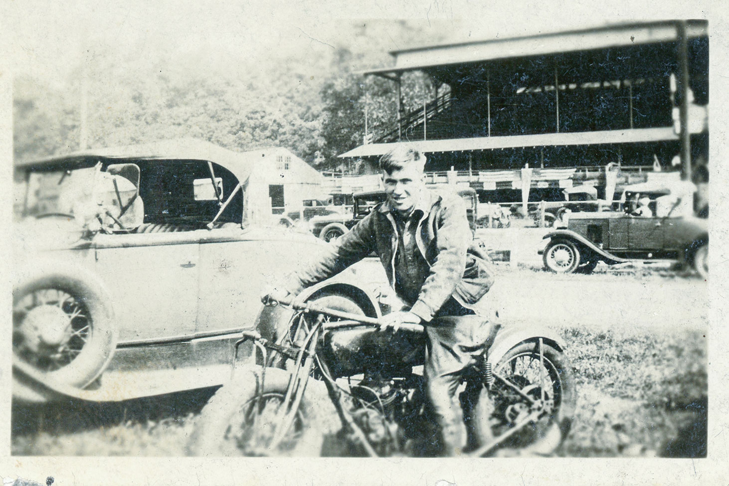
The radio announcer covering the event mistook the upside down #6 machine as the #9 and mistakenly reported that Gene Townsend had been rushed to the hospital with serious injuries. My grandmother and her young daughter (my mother) were beside themselves when they heard the broadcast. Gene promised to never worry them again and quit racing on the spot. Washie, five years his junior, competed successfully on Indian Sport Scouts through the mid-1950s, and even had a short stint as a professional racer with Gene’s backing.

Chasing Gene and Washie
Parker, Eric, and Ron leaf through a period racing program along the road to Winchester.

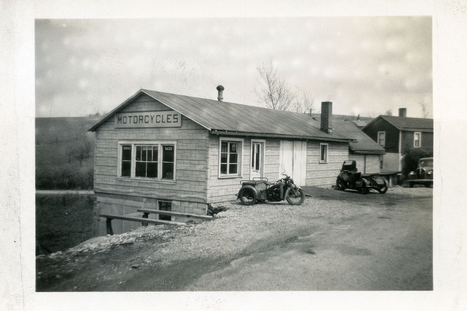
By 1948, Gene had owned his southwestern Pennsylvania Indian agency (what dealerships were called back then) for about 20 years. He had built his reputation as an exceptional rider and racer as well as an expert tuner. If Indian riders wanted the hot setup, Gene was the guy to see. Washie was granddad’s close friend, a fellow racer, and a fixture at the old shop. They shared a passion for three things: Indian motorcycles, racing, and storytelling.

Chasing Gene and Washie
Floyd “Washie” Washabaugh aboard his #64U Indian Sport Scout racer in 1948.

I only knew Washie as an older man who rode his flashy old Indian Chief to my granddad’s shop. But I envisioned him and Gene as the vibrant and courageous young dirt-track racers in the old, dog-eared photographs taken in their racing days. The deep connection I developed with these older men was something I thought only my brother and I knew. Then I heard about Washie’s grandson, Ron.

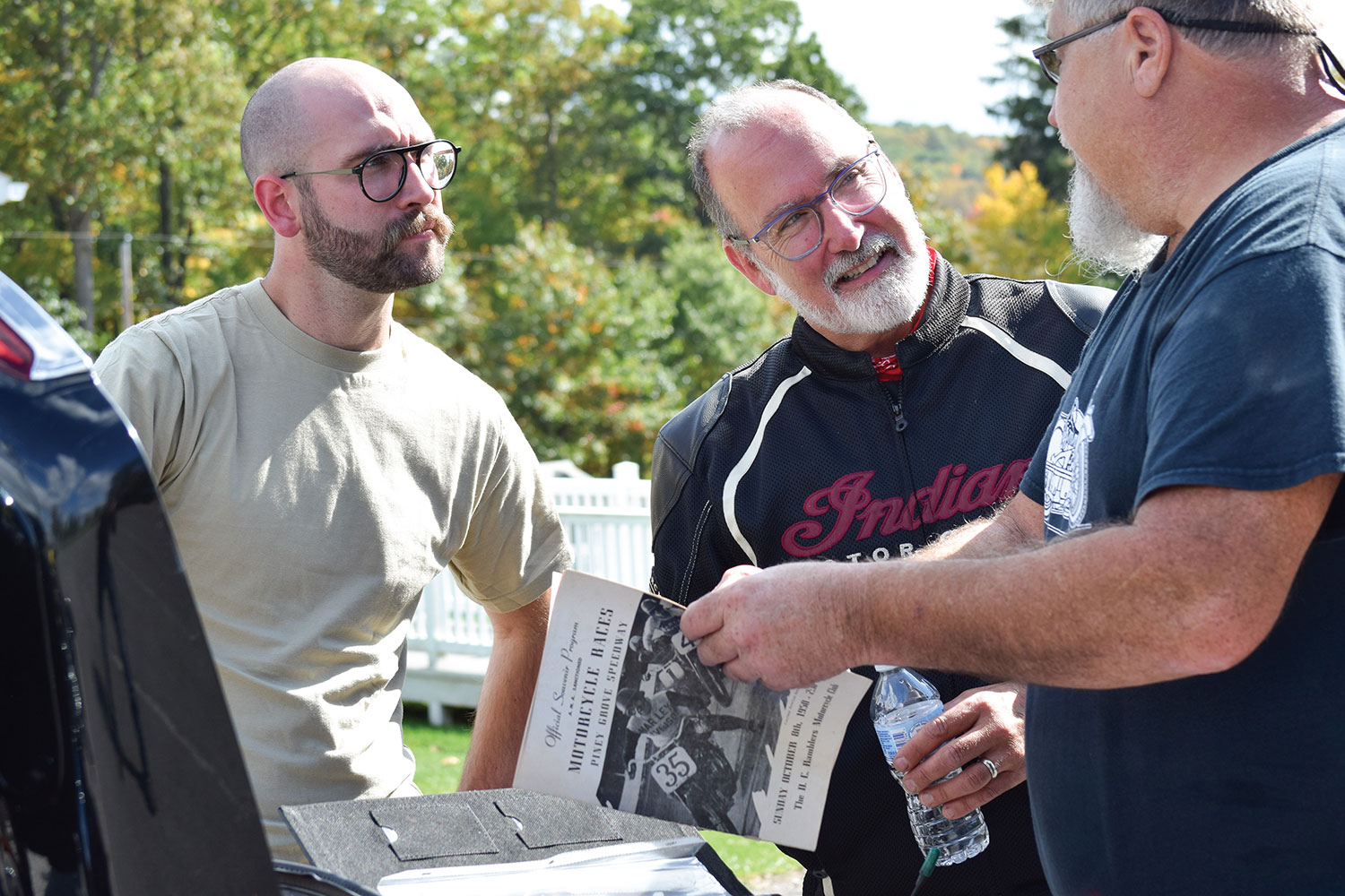
We may have met at some point at the shop when we were kids, but Ron Washabaugh and I didn’t know each other. About three years ago, we met while attending the American Flat Track races at Williams Grove near Harrisburg. We immediately hit it off and began swapping stories of that magical old motorcycle shop and the deep appreciation and fondness we had for our grandfathers.

Chasing Gene and Washie
Some sections of the old National Pike haven’t changed much since Gene and Washie rode them.

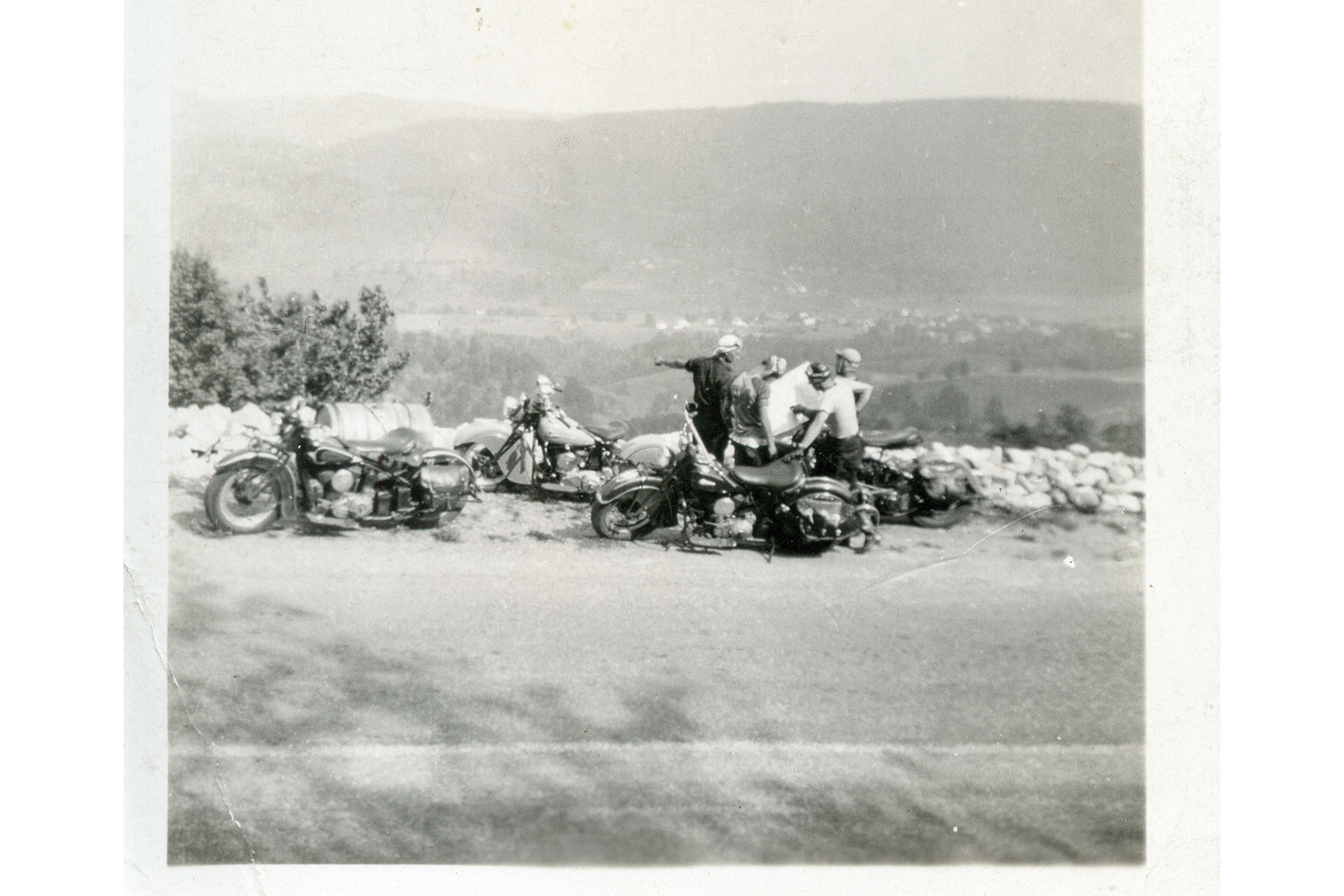
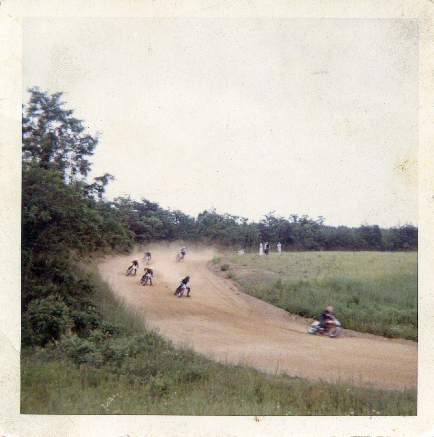
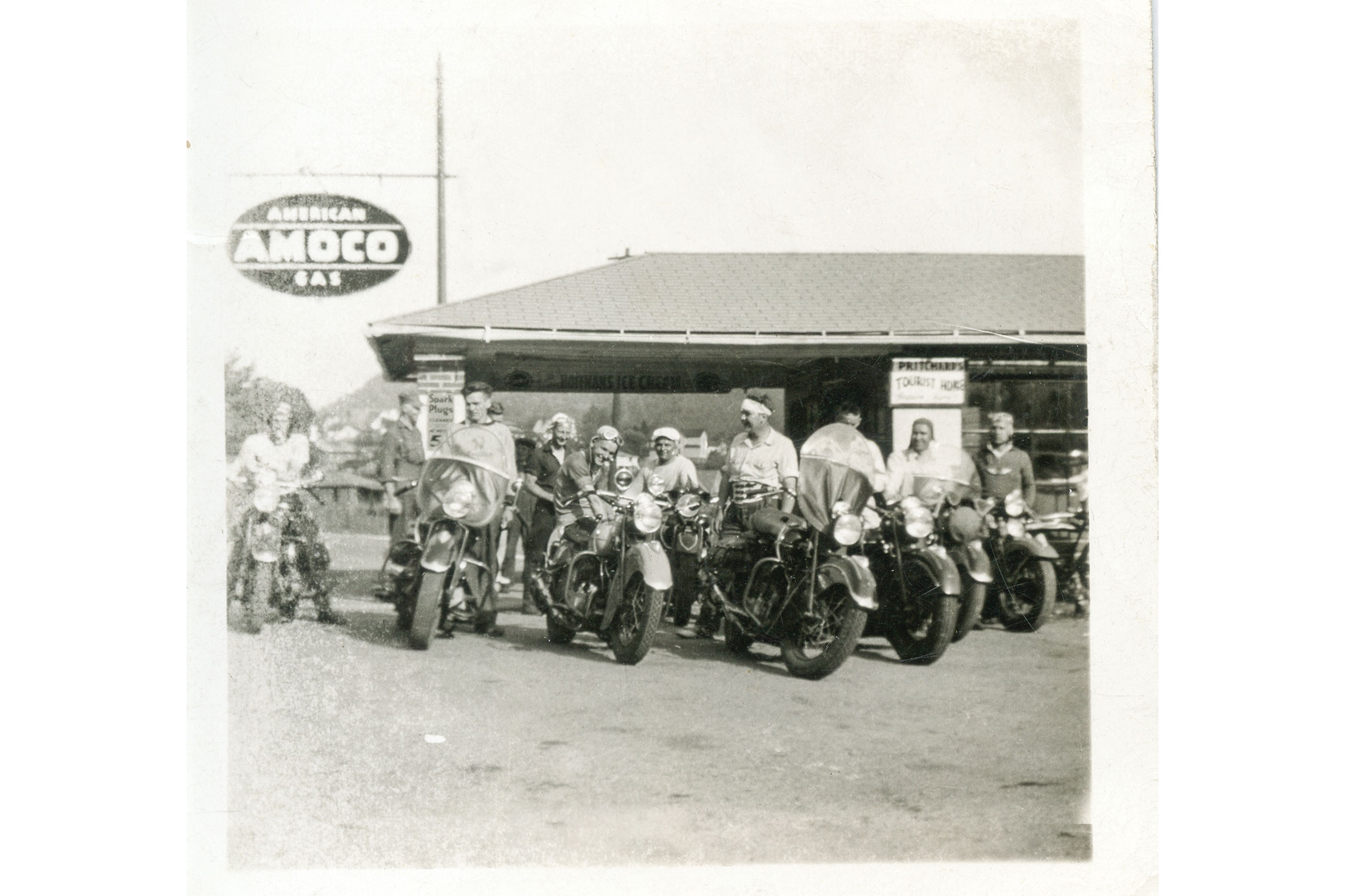
The most powerful memories for Ron and me were the racing tales told so passionately by old Gene and Washie. Through their words they painted vivid pictures of handlebar-to-handlebar racing adventures aboard their Indians on myriad local dirt tracks, as well as more distant venues such as Cumberland, Maryland, and Winchester, Virginia. They would either stuff a bike into the back of a sedan or ride their Indian Scouts to a track, remove the headlights and fenders to race, and then reassemble everything for the ride back home afterward. If they weren’t racing, they were organizing rides to watch others compete, like legendary AMA Hall of Famer “Iron Man” Ed Kretz at the Langhorne, Pennsylvania, track where he dominated the mile oval.

Chasing Gene and Washie
Stepping away from the digital GPS and iPhones, a vintage paper roadmap is used to chart the path the way their grandfathers (and great-grandfathers) would have done (below). It was a bit easier for the two older guys in the group.
Chasing Gene and Washie

Ron and I decided to retrace Gene and Washie’s path to one of the legendary tracks they rode to back in the late 1940s and early 1950s.

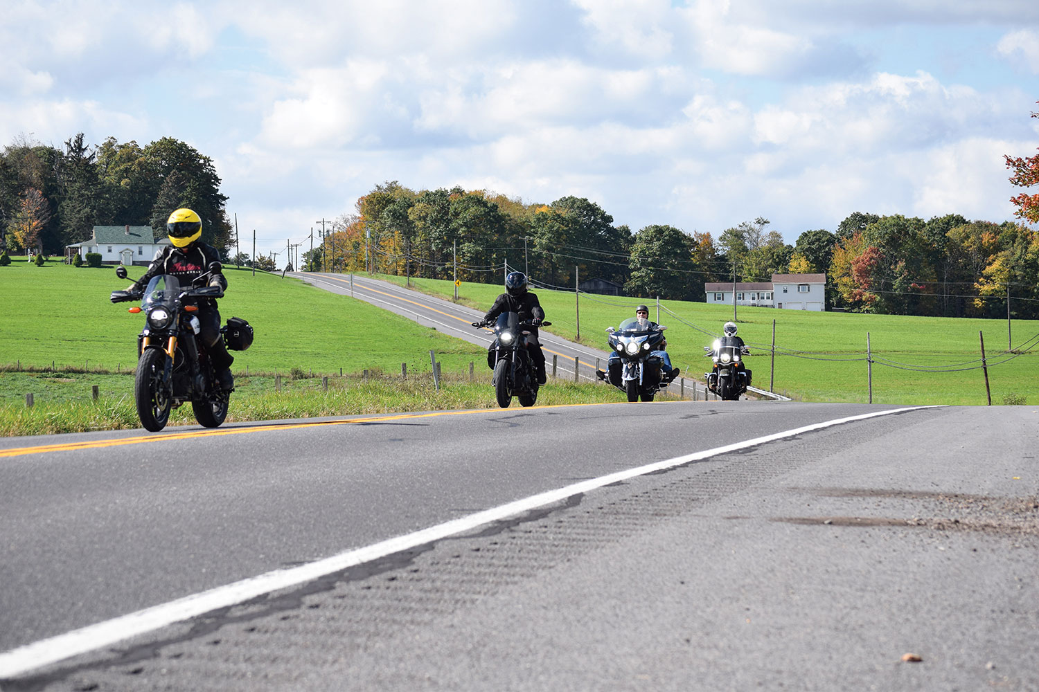
Ron and his son, Steven, and me and my son, Parker, conspired to chase Gene and Washie into the past on a journey to the old Winchester Speedway. As grandsons and great-grandsons, we would emulate the experience the two elders had back in the day. We would ride the National Road (U.S. Route 40) and other two-lane roads, stop where they might have stopped, eat at family-owned diners along the way, and find classic roadside motor lodges where they might have stayed. At every opportunity, we would celebrate their story and, at the same time, get to know each other and forge another generation of bonding around a common passion for motorcycles.

Chasing Gene and Washie
After a sprint up the mountain, the overlook atop Summit Mountain on Route 40 was a popular stop for the old boys.

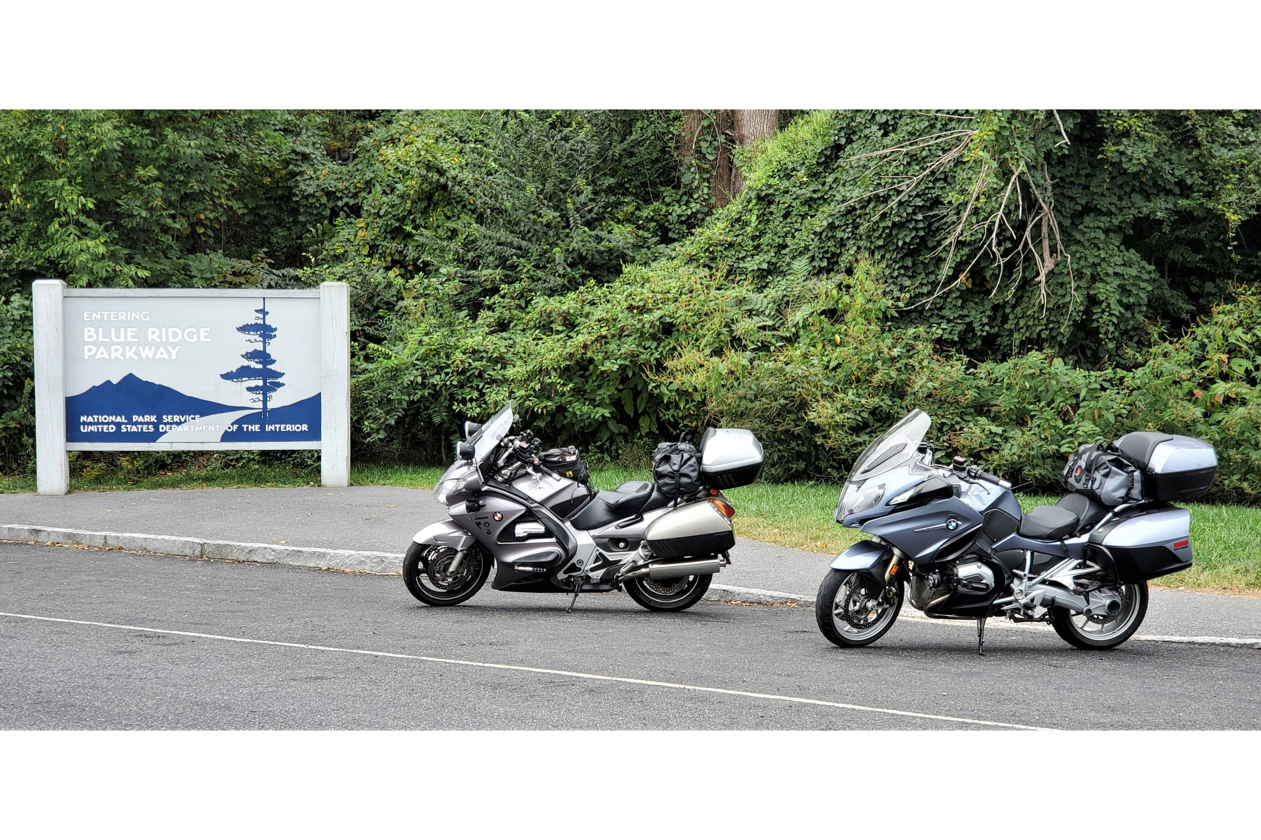
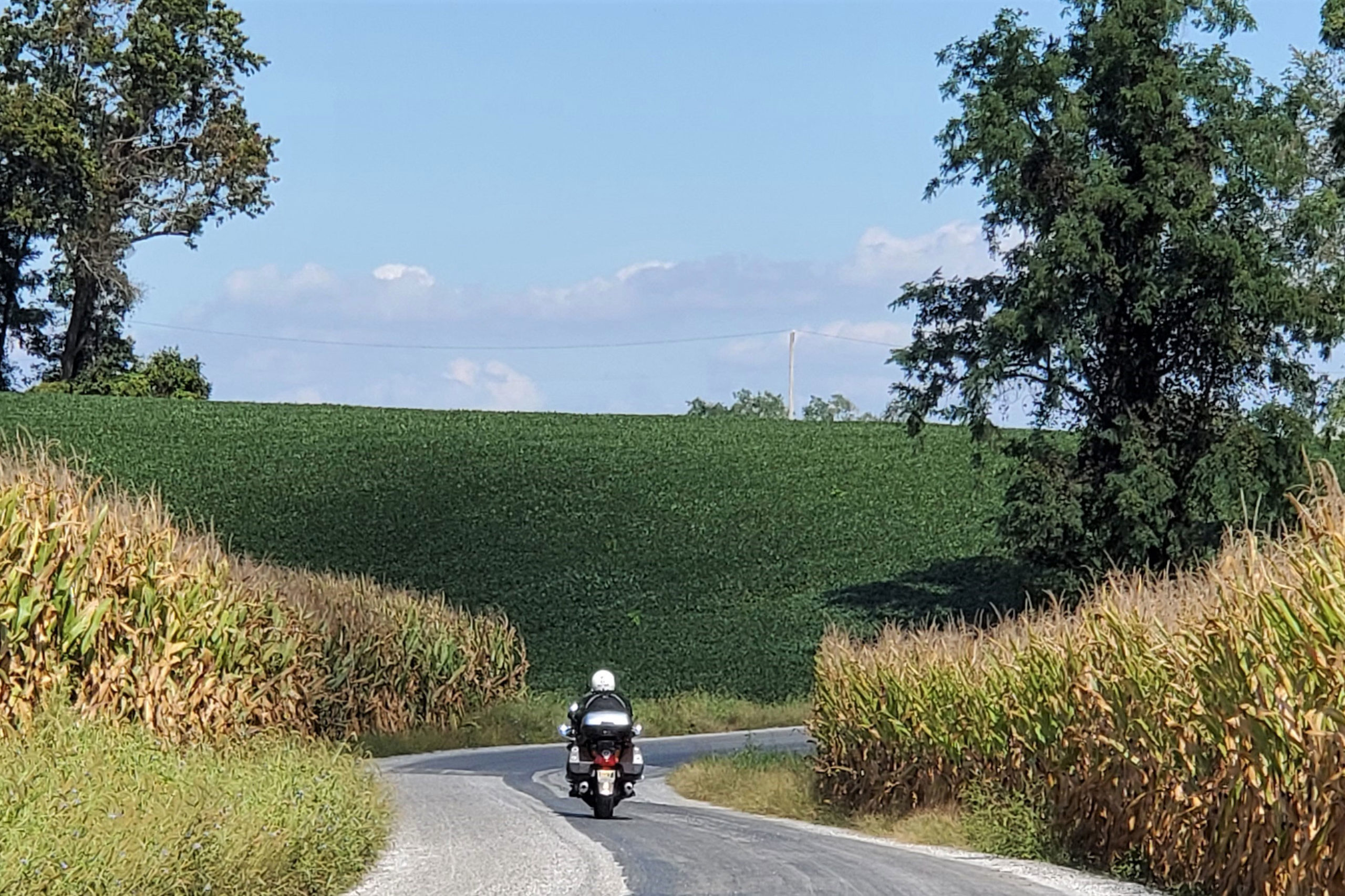
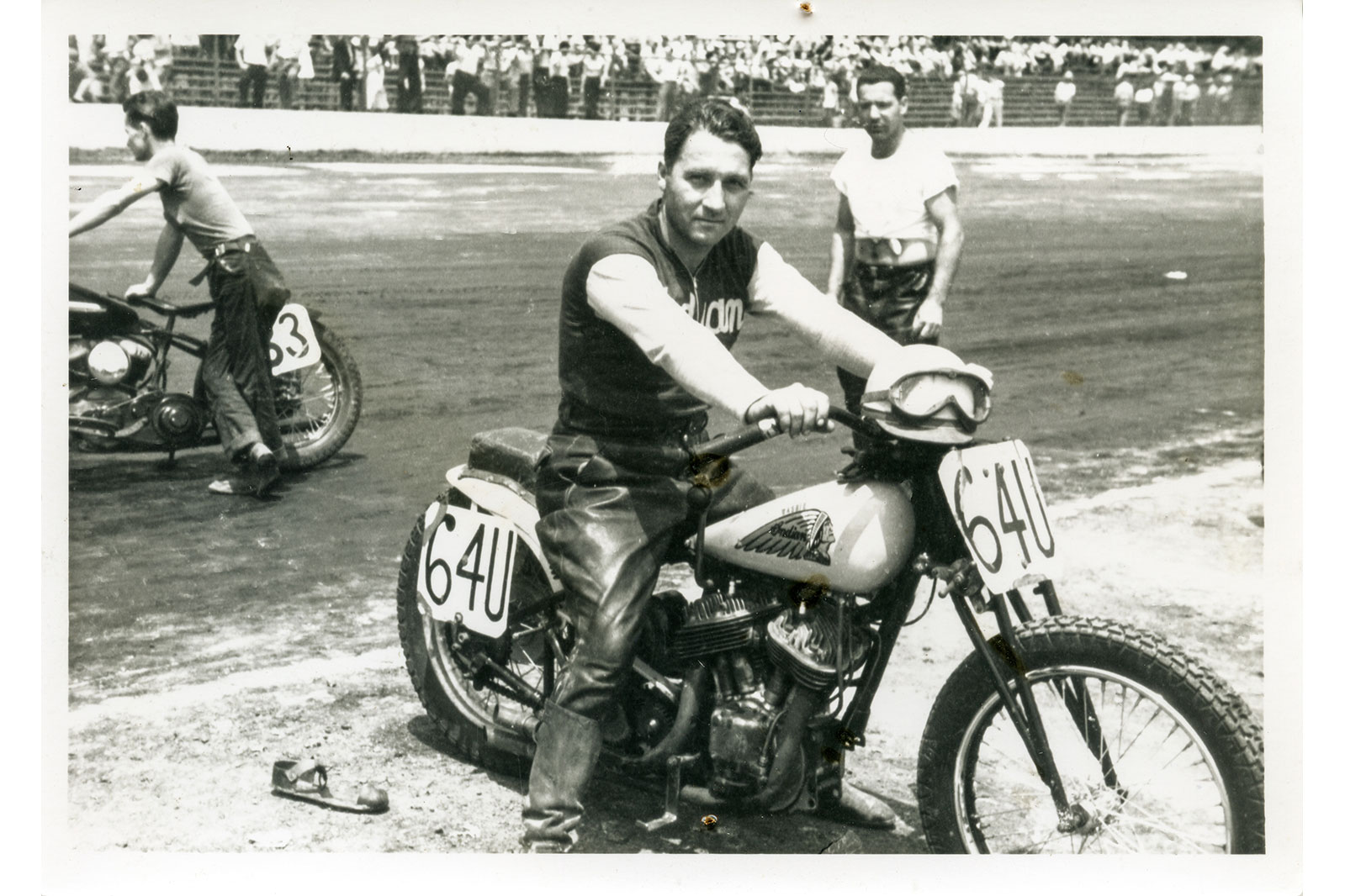
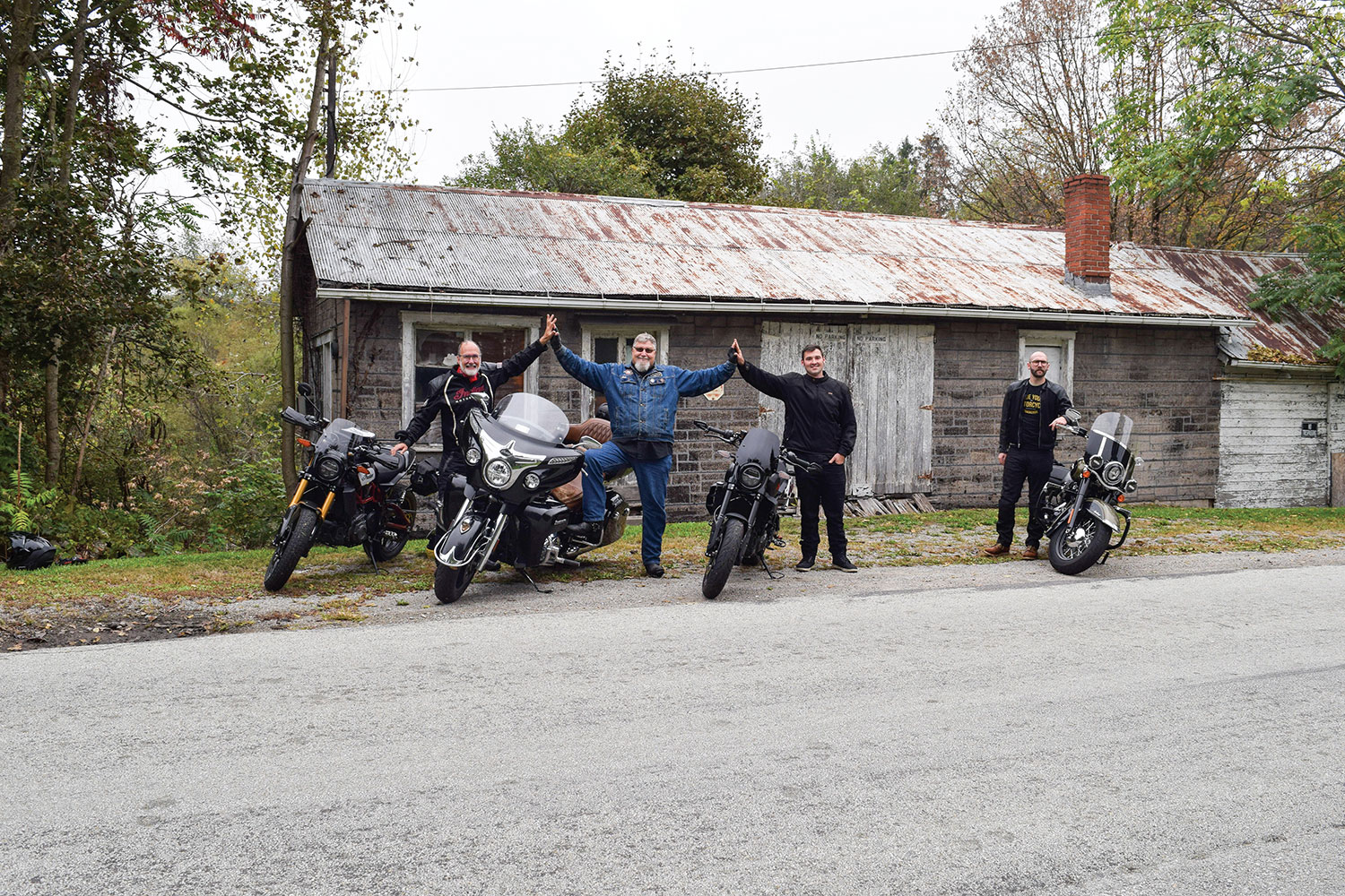
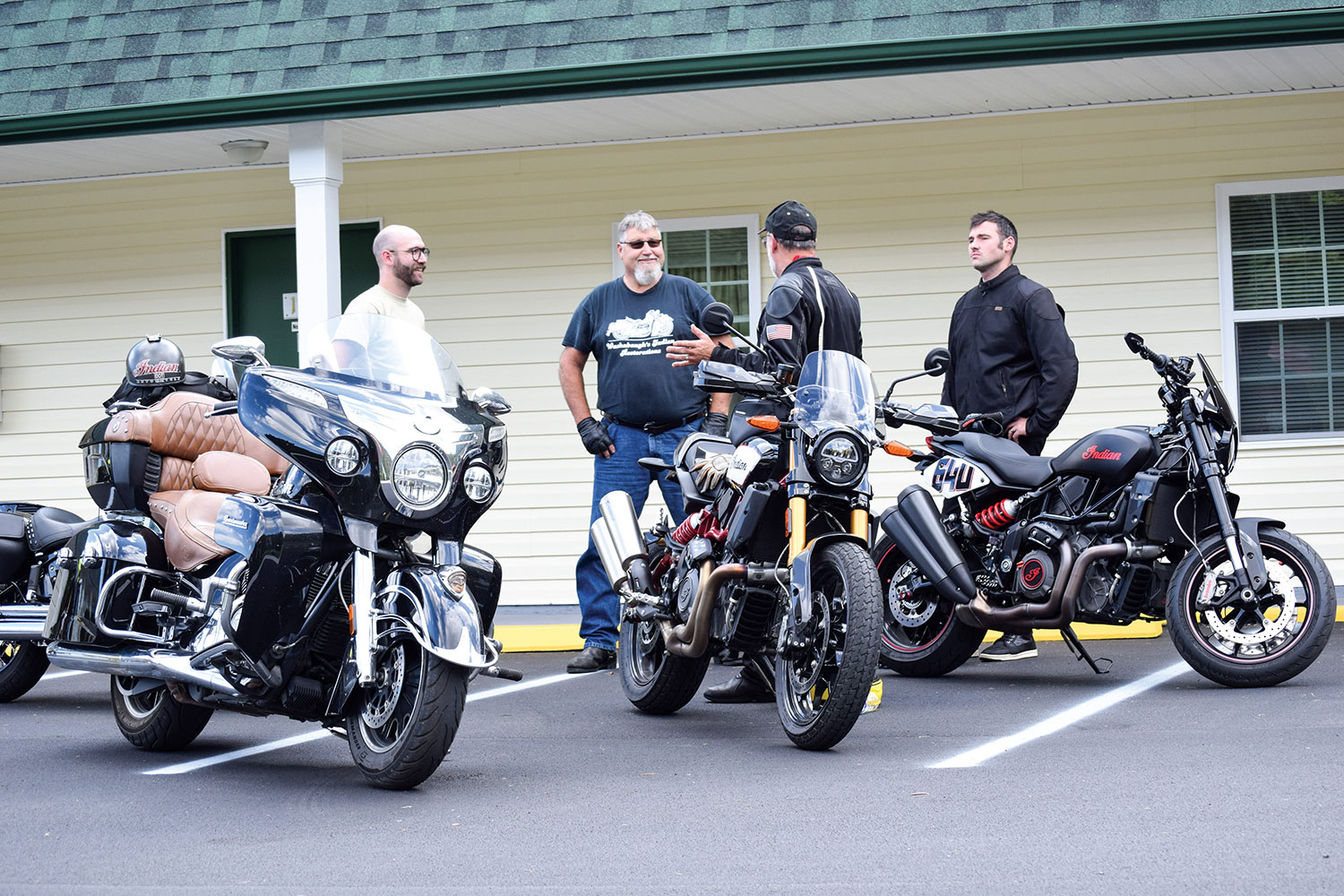
Ron and I both have vintage Indians, but for this excursion Ron was aboard his modern Indian Roadmaster, and I piloted my Indian FTR 1200 S Race Replica. Stephen rode his new FTR 1200 as well, complete with a number plate bearing his great-grandfather’s racing number, #64U. Parker rode a 2018 Harley, just for a little tension in the spirit of that old brand rivalry. (The H-D Heritage 114 is mine, and so is the kid; both are terrific, and any ribbing was in good-spirited fun.)

Chasing Gene and Washie
Eric shows the kids proper tuck technique for flat track.

Last October, the Washabaugh boys met my son and me at a diner not far from the old shop. We ordered breakfast and gobbled up the vintage photo albums Ron brought with him. Although the food and conversation were delicious, we needed to get our planned adventure rolling. There would be more time to talk along the road, so we paid the tab and headed to the old Townsend cycle shop. The unexceptional building still stands (barely) just off the National Road, three miles east of Brownsville, Pennsylvania.

Chasing Gene and Washie
Washie straddles a sidecar-mounted drum of fuel used as a rolling gas station.

The modest shop was a hub of activity in its day, a gathering place where riders regularly came and went. Some visited to see what new machines and accessories had arrived. Others stopped by for a set of points, a condenser, and maybe a pair of spark plugs on their way through town. Most wheeled in for the conversation and the stories.

It was also the headquarters and ride origination point for members of Gene’s Scouts Motorcycle Club, an AMA-sanctioned club that served as the local riders’ social group and the sponsoring organization for motorcycle competitions. Washie raced as an AMA pro for one year under the Gene’s Scouts M.C. banner. Unfortunately, after just one season, the cost proved to be too steep, and he returned to amateur racing. Some things never change for aspiring racers.

Chasing Gene and Washie
Racing at Winchester included flat track and this TT race with hills and a jump.

Soon, the engines of our Indians (and Harley) fired to life in front of the old shop, echoing the hundreds of Indians that had gone before from that same spot.

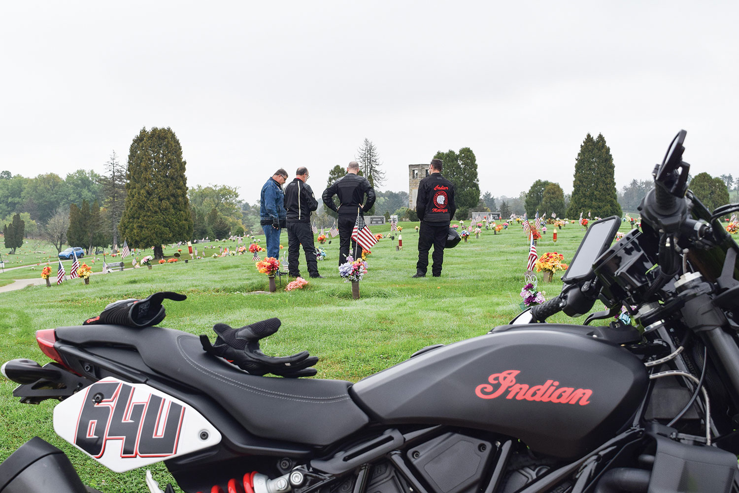
We rolled out of the parking lot and onto Route 40. The first planned stop was just up the road at LaFayette Memorial Park, where we paid our respects at Gene’s and Washie’s family plots. We thanked them for the tremendous influence they had on our lives, saluted their adventures, and invited them to ride along with us inspirit as we retraced the path they took seven decades earlier.

Chasing Gene and Washie
Gene’s Indian agency in the early 1940s.

Back on the road and heading east on the National Road, we approached Uniontown. I thought of the story Gene told me about a board-track motordrome speedway that was built there for motorcycle racing in the late teens of the last century. As a boy, he would climb a tall tree outside the grounds just to catch a glimpse of the racers flying by on the large, steeply banked wood-plank track.

Chasing Gene and Washie
Indians gather once again in front of the old Indian shop (apologies to the author’s son on the Harley).

Although the multilane highway now bypasses the towns, we took the old route that Gene and Washie would have followed through downtown Uniontown and Hopwood. We rejoined the highway on the other side where the pavement abruptly angled skyward, ascending Summit Mountain. Back in the day, this was a narrow two-lane ribbon that wound tightly up the steep hill – a rider’s dream. This stretch was the subject of many of the old timers’ stories as they recounted how they raced each other up the steep, twisting curves to the crest of the hill. They heeled their Scouts and Chiefs over so far into these corners that the frames would drag, levering the rear wheels off the ground momentarily. The trick, they said, was to hold the throttle open and let the bike reestablish traction without upsetting the chassis. Easier said than done!

Chasing Gene and Washie
Members of Gene’s Scouts M.C. at a gas stop during one of their organized rides.

Today, the road is a four-lane divided highway tracing the original circuitous path. Ron, me, and our boys turned up the wick on our machines as we ascended the hill. It was a hoot to drop down a gear and put ourselves, at least mentally, alongside our grandfathers and great-grandfathers on a spirited sprint up the mountain.

Chasing Gene and Washie
The old crew would have likely crossed this stone arched bridge along Route 40 on their way to Winchester.

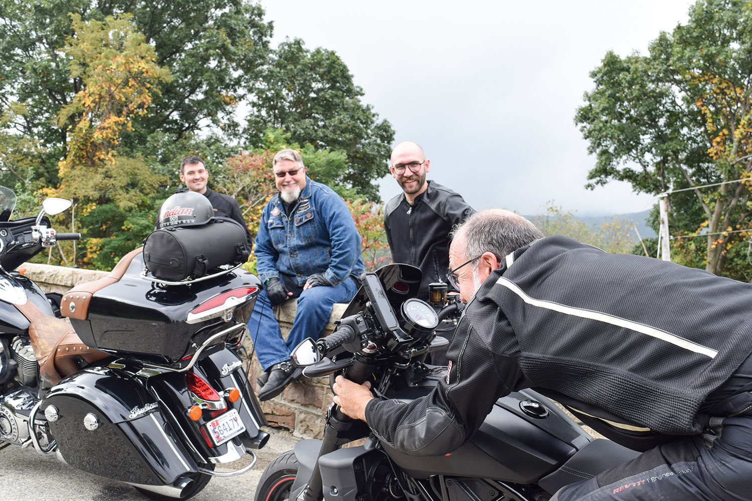
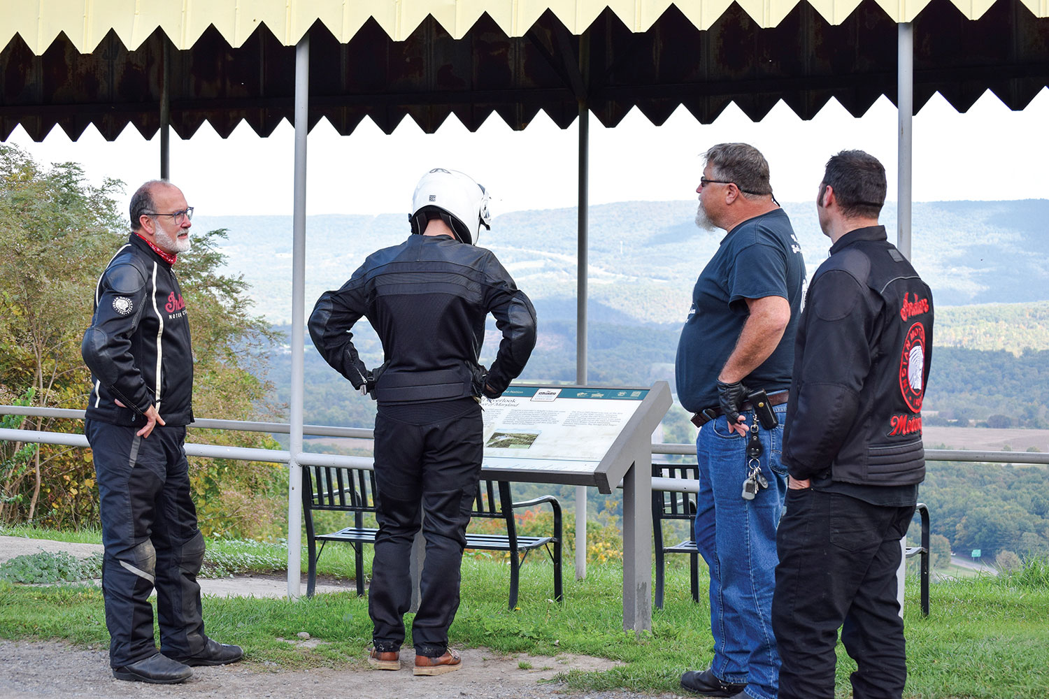
As we approached the summit, I signaled and the four of us wheeled off I-40 into the lookout at the peak of Summit Mountain. This was a spot where Gene, Washie, and the rest of their crowd regrouped countless times over the years. Summit Mountain was not just a road they took on the way to somewhere else, it was their local destination for sport riding. It’s where the guys tested their latest tuning and hop-up tricks. It’s where local Indian and Harley riders found out whose machine had the “soup” to capture the king-of-the-hill title for that week.

Chasing Gene and Washie
A typical overnight stay for the boys back in the day.

Ron and I used this pull-off to tell our sons stories we’d heard about this road and their great-grandfathers’ motorcycling adventures. We took turns contributing our own recollections, helping each other connect the dots where there had been gaps in our individual knowledge. Parker and Stephen stood by, soaking it all in.

Chasing Gene and Washie
Surely Gene and Washie would have stopped for the overlook at Town Hill.

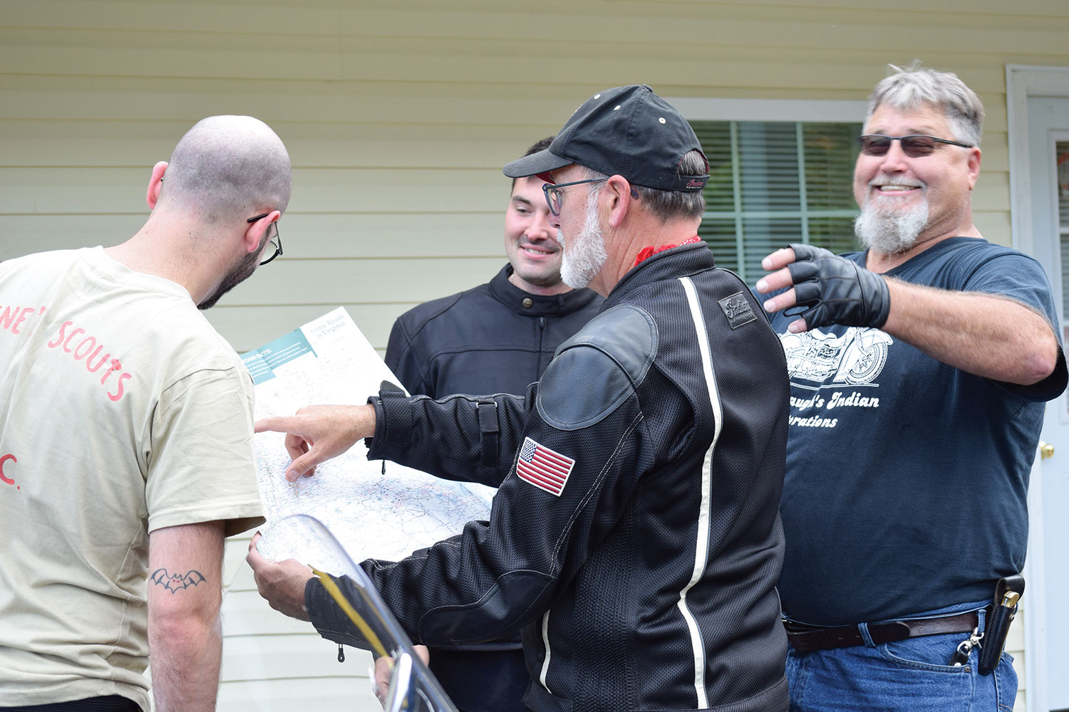
Back on the road, we imagined the roadside stops the men might have made along their way. We proposed where they may have paused to stretch their legs, consult a map, check chain tension, or maybe add a quart of oil. Then we’d stop too. We took advantage of those roadside breaks to look through collections of old racing photos, racing publications, and pictures our grandfathers and their pals had taken along the road to different racing venues.

Chasing Gene and Washie
The Clarysville Motel in Frostburg, Maryland, has been operating for 100 years.

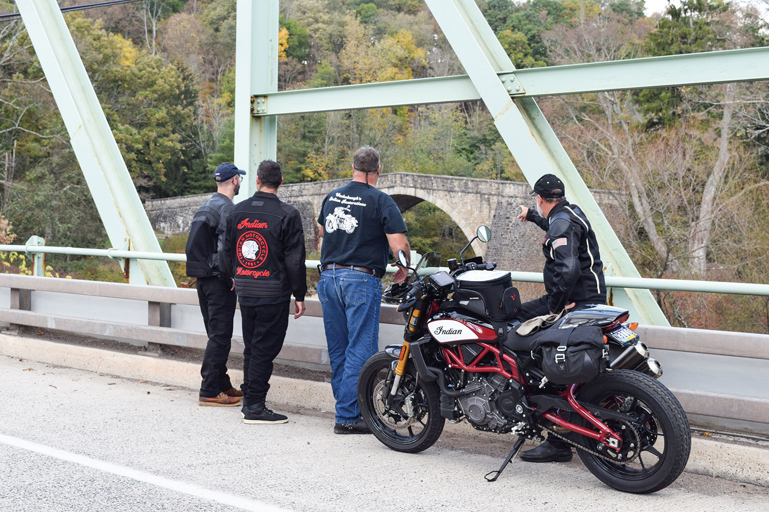
On occasion, we saw a turnoff to Old Route 40, most often a short spur of narrow two-lane that soon rejoined the newer main road. It was fun to ride a few of these old sections to capture the ride experience Gene and Washie had, but it was impractical to take each little detour. Other times we saw sections of Old Route 40 that were no longer accessible, including an area where an old stone arched bridge was once the path of the old National Pike. Gene and Washie probably traveled that same old stone bridge on their way to Winchester. We could only view it from the main road.

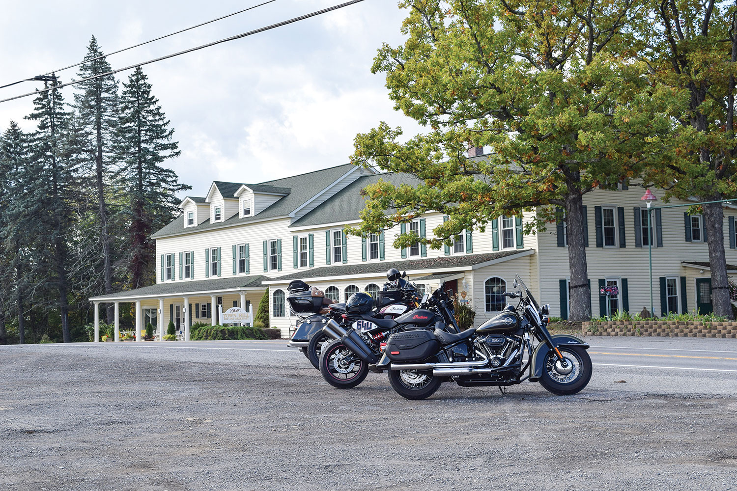
We paused at the old Clarysville Motel that looked like it might have been there when our grandfathers rode through. As it turns out, the place has been serving travelers for nearly 100 years. Other than the modern vehicles in the parking lot, it would be hard to distinguish 2021 from 1948 or earlier. Certainly, Gene and Washie rode by here many times, and may have even stayed on occasion when daylight expired.

Chasing Gene and Washie
The inn at Town Hill, Maryland, would have likely looked the same for the Gene’s Scouts crew in the 1940s.

In Maryland, the old highway began to rise, fall, and twist dramatically. This was the kind of road on which the boys surely had the old Indians dancing. They would have been intimately familiar with this fun section of road, knowing what lay ahead and anticipating it well in advance. After navigating a particularly enjoyable stretch, we crested a hill to discover the historic Town Hill Inn and overlook. This was a likely rest stop for Gene and Washie along their ride. It was a natural place to take a breather, check over the bikes, and enjoy the spectacular view across the wide valley below.

Chasing Gene and Washie
When not on the track, Gene’s Scouts were in the stands to watch their buddies race.

In Hancock, Maryland, we picked up Route 522 south and rode through quaint, historic Berkeley Springs, West Virginia, and on south into Virginia to our destination of Winchester.

Once in downtown Winchester, Ron led us to an iconic spot for a hot dog. Whether Gene and Washie ever stopped at this historic stand for a dog when they were in town, we’ll never know. But just in case, we thought we’d better have one since we were trying to capture the experience.

Chasing Gene and Washie
Grandsons and great-grandsons pause at the Winchester track to reflect on two diehard old racers.

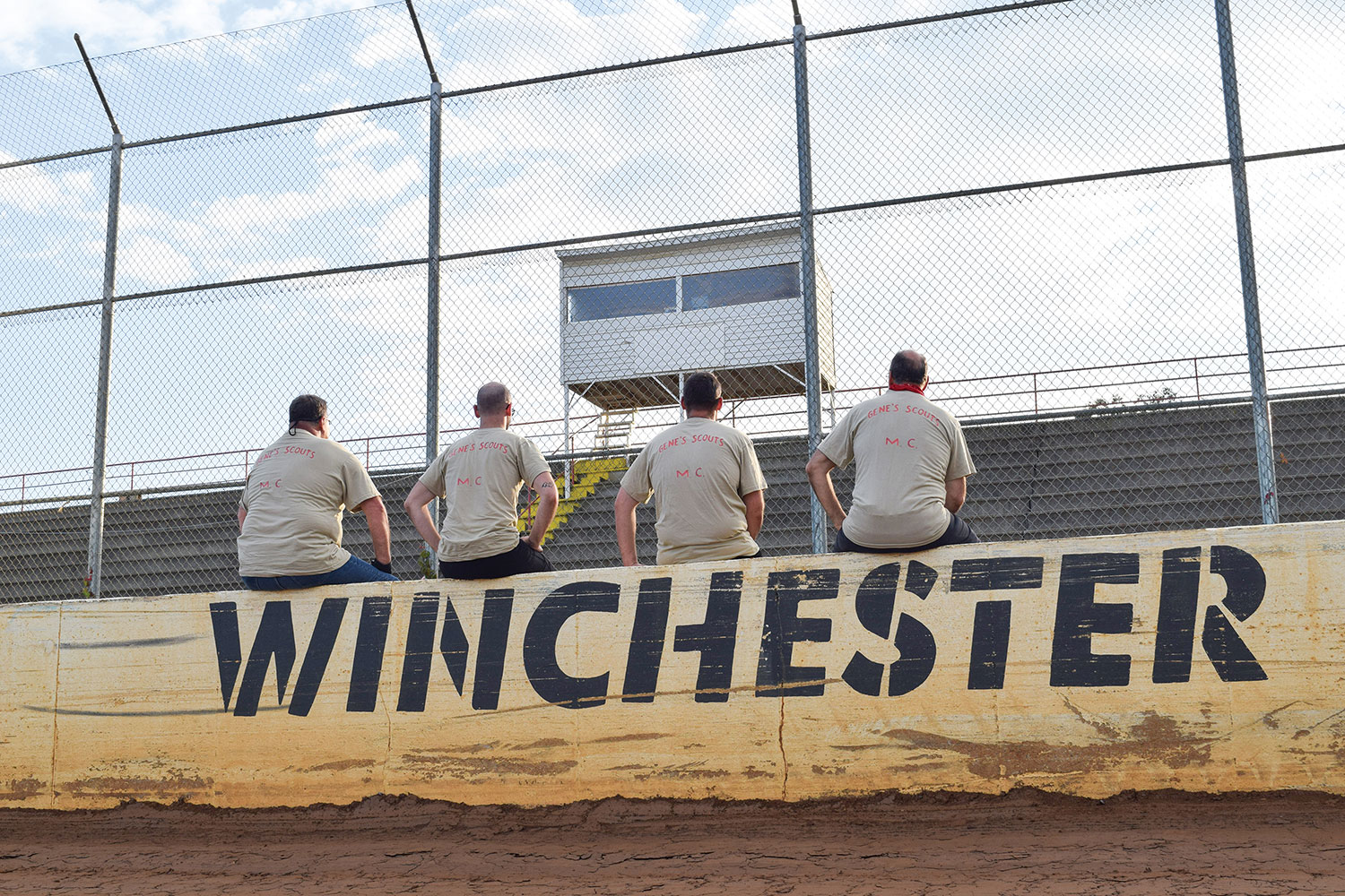
Since the Winchester Speedway is sometimes referred to as the old airport speedway, we meandered through the town following directional signs for the airport. After working our way along narrow roads that wound around the airport property, we came to the end of the road and were unexpectedly at the back side of the racetrack. No big sign. No grand entrance. As a lot of these rural speedways were, it was simply a venue where people gathered. The raceway was probably not much different than it was when Gene and Washie were last here together, except now the old wooden grandstands are gone, replaced with concrete and metal.

Chasing Gene and Washie
Gene carves up the clay on an Indian Scout.

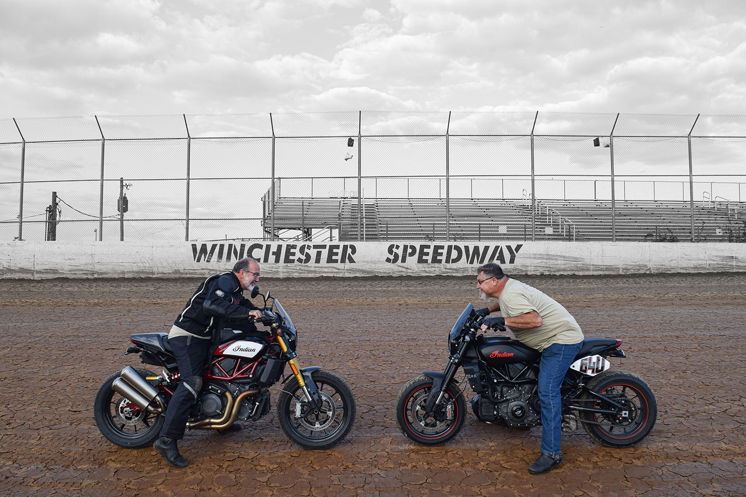
The beauty of these local facilities is how approachable the track personnel can be. We arrived midweek in the middle of the day and told our story. Hoping to have a picture taken outside the track at the speedway sign, our plan was thwarted when we realized there was no such sign and no suitable backdrop. Fortunately, the track folks invited us to bring the bikes onto the track and position them in front of the wall on the back straight where “Winchester Speedway” was painted in bold lettering. It was perfect. Ron couldn’t resist the temptation to ride around the dirt track just to run tires on the same clay that his grandfather once tore up on the #64U Indian Sport Scout.

Chasing Gene and Washie
A lineage of Indian men chased their ancestors Gene and Washie to Winchester Speedway to rev up their legacy for another generation.

We were all having a great time and didn’t want the adventure to end, but the autumn sun was already sinking low in the sky. With our mission completed and an abundance of pictures taken to commemorate our expedition, it was time to say our goodbyes. Ron and Stephen had about a two-hour ride east to get back home. Parker and I needed a bit longer for our westward trek on modern interstate highways back toward Pittsburgh.

On the way home through the darkness, I replayed the ride over again. In my mind, I overlayed images of Gene and Washie from 70 years ago on today’s images of Ron, Stephen, Parker, and me riding the same roads to Winchester. It felt good to ride with other descendants. It felt even better to be together, chasing Gene and Washie.

Chasing Gene and Washie
The ride began with a visit to the resting places of Gene and Washie. They were then invited to ride along in spirit.

POSTSCRIPT

As much as the Indian boys would love to hear that the Harley broke down so often that we were forced to abandon our plans (or abandon Parker), the Heritage 114 did just fine. While it’s fun for us to see the old Harley and Indian wars heating up once again in this modern era (we can hear Gene and Washie piping in from the great beyond), the real benefit of that rivalry has been the development of better motorcycles from both brands. A little competition is a good thing, though Gene and Washie would still give Indian a slight edge. After all, it’s in their blood.

The post Chasing Gene and Washie: An Indian Tale first appeared on Rider Magazine.
Source: RiderMagazine.com

Muriel’s First Ride

Muriel's First Ride
Connecticut Route 43 has new tar, which encourages a pace Muriel would not have preferred. Photos by the author.

She’s taking her first ride on a motorcycle. Posthumously, as it turns out, but my Aunt Muriel is along for the ride, her ashes secretly stowed in my top case.

Muriel had not been a fan of motorcycles. She found them too fast and noisy and their riders too careless and selfish. For decades she lived near the coast in south Florida where a grid of congested, multi-lane streets put motorcycles right next to her. The ones she encountered, at least the fast and loud ones that stood out in her mind, didn’t give her much to like.

Muriel's First Ride
East River Road in Riverton, Connecticut, winds along the Farmington River through People’s State Forest. Muriel’s ashes are along for the ride, stowed in my top case.

While she enjoyed hearing stories of my long-distance adventures on motorcycles, she always made one thing quite clear: “You will never get me on a motorcycle!”

Now, as the miles are adding up, a thought keeps bouncing through my brain: Would Muriel have found this ride okay?

Muriel's First Ride
Muriel with Steve Efthyvoulou (right) and your humble scribe on one of our two-wheeled visits to her home in the North Carolina mountains.

Her attitude about motorcycles and their riders evolved after she retired and moved to the mountains of western North Carolina – one of the best motorcycling regions anywhere. When Muriel first took up residence in the town of Franklin, my wife, Sheila, and I drove down for a visit. Muriel drove us to lunch at a barbecue place she liked in the town of Highlands.

As we motored south on State Route 28, the road became tremendous, with baby’s-bottom-smooth tar and continuous tight turns, nicely banked. On one side of the road were jagged outcroppings, and on the other a fast-moving river in a rocky ravine. She pulled her car into a lay-by and drove us behind a waterfall.

Muriel's First Ride
On U.S. Route 221 west of Blowing Rock, North Carolina, a face seems to be emerging from the mountain.

Muriel was not what you’d call an expert driver, but to her credit, she stayed in her own lane on this intensely curvy road. Sheila was pregnant at the time and sat nervously in the back seat, clutching her rounded belly and hoping our destination was close. In stark contrast, I was thinking how fantastic this road would be on a motorcycle. I mentioned this to Muriel, and she suggested I come back riding one. “Bring a friend,” she said. “More than one if you like.”

This invitation, I later learned, was despite a homeowner association rule that did not allow motorcycles in Muriel’s neighborhood. “I don’t have a motorcycle,” she explained, “but if visitors come to see me and arrive on their cycles, there’s not much I can do about that, is there?” Muriel believed that it is easier to ask for forgiveness than permission.

Muriel's First Ride
Our bikes cast early morning shadows on corn ready for harvest in Franklin Township, New Jersey.

Over the next 15 years, I took every opportunity to visit her with one, two, or three friends on motorcycles. We would arrive on quiet Hondas and BMWs, ride slowly through her neighborhood, and offer a friendly wave to anyone we encountered. Forgiveness was never required.

Muriel’s home was on a hilltop, providing an impressive view of the mountains where those roads we came to ride lay waiting. Her neighborhood emptied onto Route 28 (aka Moonshiner 28), and gems like Wayah Road, the Cherohala Skyway, U.S. Route 129 (Tail of the Dragon), and the Blue Ridge Parkway were there to be enjoyed. On every visit we discovered new roads.

Muriel's First Ride
Where the Skyline Drive ends, the Blue Ridge Parkway begins.

We’d return from a day’s ride excited and full of stories, then take Muriel out for dinner. Over these meals, she got to know an orthopedic surgeon, a military logistician, a powerplant engineer, a metal fabricator, a warehouse manager, and a truck driver – each a gentleman, a gracious guest, and a motorcyclist.

Muriel's First Ride
Steve pilots his Honda ST1300 through a corridor of corn.

One time Muriel casually asked if we’d help her change out the storm windows for screens. “You’ll keep an old lady off a stepladder,” she explained. We installed those screens, and on every subsequent visit we asked for her honey-do list. Leaky faucets, wobbly towel bars, and uncooperative wi-fi never stood a chance. Muriel came to appreciate that not every motorcycle was too fast and noisy, nor every rider too careless and selfish. When talking with her church lady friends, she referred to us as her gentlemen friends on motorcycles.

Muriel's First Ride
This Lancaster County, Pennsylvania, Labrador pup approached us in full wag mode but was quickly corralled by his protective mother. (Good dog.)

Now, on a warm Sunday at summer’s end, I depart my home in western Massachusetts and point my BMW R 1200 RT south and west. Weaving through the Berkshire Hills of Connecticut, I seek out places Muriel would have liked: Saville Dam in Barkhamsted, East River Road overlooking the Farmington River, and historic covered Bull’s Bridge across the Housatonic River. At the New York border, the road becomes Dogtail Corners Road … Muriel would have chuckled at the name. She would have been less amused by the 10-mph hairpin turns on Dutchess County Route 22 east of Pleasant Ridge Road, but I lean in to savor them.

Muriel's First Ride
Muriel would have chuckled at the other name of Dutchess County Route 22 in New York State.

I curve through the Bear Mountain and Harriman State Parks into scenic northern New Jersey, where Steve Efthyvoulou joins the ride. Over the years, Steve arrived at Muriel’s on a motorcycle more often than anyone except me, and on this ride, he is helping me to fulfill a request: Muriel had directed that her ashes be “scattered in the North Carolina mountains.” No specific location was indicated, so I asked Steve to join me in seeing this through appropriately. He agreed without hesitation.

Muriel's First Ride
Amish farms like these present a pastoral landscape in Lancaster County, Pennsylvania.

The next morning, we are rolling at first light. Steve has plotted a route to keep us off main roads, so we’re riding through small New Jersey towns, past fields of corn ready for harvest. We cross into Pennsylvania, and in Lancaster County the distinct sights of Pennsylvania Dutch country abound. Amish farmers with a team of four mules are harvesting the first row of corn, right next to the road. A bonnet-clad teacher is holding class outside as children dressed in homespun clothes sit attentively. Farther on, an older group of boys enjoys recess on a baseball diamond. I’ve been told Monday is laundry day for Amish families, and countless clotheslines brimming with union suits and long-legged underpants offer anecdotal evidence. At an intersection, a young buggy operator struggles with her charge. Steve points out that teenagers aren’t typically the best drivers – even when driving a horse.

Muriel's First Ride
As we return north through Virginia, this Blue Ridge Parkway lay-by at 3,700 feet elevation affords a panoramic view of the Arnold Valley.

On Pennsylvania Route 372 we cross the expansive Muddy Run hydro power project, which uses excess power from the grid to pump water from the dammed Susquehanna River into a lake. During peak power demand, water flows down from the lake through turbines that generate electricity. The lake, essentially, is a battery. It’s also the center of an area operated as a park.

Midday finds us in Maryland, and what would a lunch stop in the Free State be without crab cakes? Muriel would have given two claws up. After a brief run through the state of West Virginia, we continue through western Virginia to Harrisonburg for the night.

Muriel's First Ride
My bike’s reflection reveals steady rain during a break on the BRP.

In the morning we hop on Skyline Drive to curve through Shenandoah National Park. On a dreary weekday after Labor Day, the few vehicles we encounter are noticeably disregarding the painfully slow 35-mph speed limit. After we join the Blue Ridge Parkway, the rain begins. Beyond Roanoke we shift to U.S. Route 221, and the rain continues to fall hard and steady, but as Steve reminds me, a great road in the rain is still a great road. In the town of Boone, North Carolina, we call it a day. Torrential rain and flash flood warnings will continue through the next 36 hours, so we opt for a rest day in this happening college town in the mountains.

Muriel's First Ride
The 35-mph speed limit on Skyline Drive provides all kinds of time to take in the scenery. Muriel would have liked that more than we do!

A day later, morning arrives with brilliant sun and temperatures in the low 40s. With heated gear plugged in, we make an early start. Branches and limbs litter the roads in a testament to the fierce storms that had rolled through. Steve shares warnings of road hazards ahead, a great benefit of bike-to-bike intercom. Especially in this region of Appalachia, the mountains form a creased and crumpled landscape, and the roads built into it twist and turn like a roller-coaster ride that you control. Rock outcroppings are common, and some are fascinating, such as one on U.S. 221, west of Blowing Rock, that looks like a face emerging from the mountain. Beyond North Cove we turn right on State Route 226 and left on State Route 226A to partake in another asphalt masterpiece.

Then, somewhere beyond Little Switzerland, an appropriate spot in the North Carolina mountains reveals itself and Muriel’s final request is fulfilled.

Muriel's First Ride
Dense gray clouds signal impending rain on Skyline Drive in Shenandoah National Park, Virginia.

Professionally, Muriel had been a city clerk, certifying elections, officiating weddings, and serving as president of the municipal clerks’ international association. She traveled extensively for work and in retirement. A simple church-going lady, she loved conversation, voiced strongly held opinions, and agreed to disagree (agreeably). One thing Muriel and I disagreed about was motorcycles, though curiously they brought us closer together. She knew how much motorcycles matter to me and that she lived in a special place to enjoy them, so of course I should come visit with friends.

On this trip, I gained the satisfaction of ensuring that Muriel’s wish to find rest in the mountains of North Carolina was met, and in the process Steve and I enjoyed some amazing roads. But there’s no escaping the irony that Muriel’s final ride was also her first ride on a motorcycle.

The post Muriel’s First Ride first appeared on Rider Magazine.
Source: RiderMagazine.com

The Pennsylvania Wilds

The Pennsylvania Wilds
The author’s Kawasaki Voyager 1700 basks in the sun alongside rolling Route 660 and the lush farmland near Pine Creek Canyon. A Pennsylvania dairy farm near Wellsboro stands proudly in the morning sun.

When I want to escape the daily grind for a few days, any motorcycle excursion I choose must have great roads, beautiful scenery, parks and interesting places to visit. The ride getting there is just as important as the destination, too. Rolling west on scenic roads through New Jersey and New York to the heart of Pennsylvania adds to the adventure. The North-Central Pennsylvania Wilds region contains 2.1 million acres of public land and is one of the least populated areas in the northeast.

With hundreds of miles of roads to explore and small towns with a 1950’s vibe that dot the landscape, the Wilds’ forests and mountains are also home to elk, bear, deer, coyote, fox and rattlesnake. In fact, if you really want to add an extra level of excitement to the trip, visit in the spring and participate in one of the annual rattlesnake roundups.

The Pennsylvania Wilds
Some of our group celebrating atop Hyner View State Park (from left: Wild Bill, Maggie May, Nordic Linda, Road Captain Ken, and in back, Woodstock Mark).

When I started talking about my trip, I thought a few friends might be interested, but eventually 12 riders on 10 bikes wanted to join me—a bit of a large group but manageable. Morning rain delayed our departure time for more than an hour, and we still left Ringwood, New Jersey with it coming down. Traveling west, we bounced along on the two-lane Greenwood Lake Turnpike and weaved alongside the lush forested mountains that line the blue waters of the Wanaque and Monksville Reservoirs. Climbing up and over Bearfort Mountain, we rode through a section of the 34,350-acre Wawayanda State Park and into the expansive farmland of the Pine Island black dirt region of New York State.

At Port Jervis the rain took a respite and we blasted off on Interstate 84, a scenic highway that cuts through the forested hills of eastern Pennsylvania. On weekdays, traffic is usually light. My Kawasaki Voyager 1700 handled the backroads with aplomb and did the same on the Interstate, eating up 65 miles of highway in no time along with the other nine bikes.

The Pennsylvania Wilds

Taking Interstate 81 north to Waverly, we had a tasty lunch at the Camelot Restaurant and Inn. After lunch, the sky had cleared and the sun gazed down upon us like a mother admiring her newborn. Traveling west on State Route 632, this curvaceous two-lane road led us to famous U.S. Route 6, also known as the Grand Army of the Republic Highway. It honors the Union Civil War Veterans and travels 3,199 miles from Bishop, California to Provincetown, Massachusetts.

At Russell Hill, we exited Route 6 onto the rural and rustic State Route 87, which for the most part is decently paved and serpentines through wave-like Pennsylvania farmland devoid of any large towns. However, for the rest of the day’s ride, Mother Nature toyed with us like a heartless bully: rain then clearing, rain then clearing and so on.

The Pennsylvania Wilds
Facing the Loyalsock Creek, the Forksville Methodist Church epitomizes the rural style of Pennsylvania churches.

We continued on Route 87 to the Forksville Covered Bridge. Built in 1850, the 152-foot-long bridge crosses Loyalsock Creek and is on the National Register of Historic Places. Since Wild Bill and Woodstock Mark wanted a snack, we stopped at the Forksville General Store & Restaurant, erected in 1851. The store’s motto is “Let’s get forked up.” It is known for its Philly cheesesteak sandwich, as well as other culinary delights. Nearby the Worlds End State Park has scenic overlooks, a swimming area, a campground and cabins.

Backtracking to State Route 154, which is a more rural route than Route 87, we weaved and bobbed through farmland and forest, the road occasionally caressing small villages where at times we felt like we had sailed into the 19th century. For the most part, this country road was in good condition all the way to State Route 414.

The Pennsylvania Wilds
Wild Bill gets his “cool on” while posing with our machines at Hyner View State Park.

At State Route 287, we roared north to Wellsboro, gateway to Pennsylvania’s Grand Canyon area and our home for the next two nights. Excellent views of the Canyon can be seen from Leonard Harrison and Colton Point State Parks, both roughly a 12-mile ride from Wellsboro. Officially named Pine Creek Gorge, it is almost 50 miles long, more than 1,000 feet deep in spots and a mile across at its widest. A rail trail runs the entire length of the gorge, which is surrounded by 160,000 acres of the Tioga State Forest.

Settled in 1806, Wellsboro’s population is 3,328, and its gas-lit streetlights and Victorian Mansions date back to the early 1800s. The town’s two-storied Main Street architecture screams rural America, and restaurants are within walking distance of several motels. After a hearty meal at the family owned The Steak House Restaurant and a few celebratory libations, we called it a day.

The Pennsylvania Wilds
Time for a map check on Route 44 before entering the 215,500-acre Tiadaghton State Forest.

Saturday greeted us with sunshine and blue skies. We left early, our caravan of motorcycles pulsating through the cool morning air as we rumbled through Wellsboro to the friendly waves of locals. Heading south on State Route 287, we stormed through the countryside like the cavalry charging (Fort) Salladasburg, one of only five villages on this 36-mile section of road. State Route 973 led us west into a tunnel of greenery that enveloped this twisting, hilly roadway to State Route 44 north, which plunged us ever deeper into the Wilds.

Finding Hyner Mountain Road proved a bit challenging, so I stopped to consult my map and also asked Warp Speed Vito to program the road into his GPS. Approaching the turnoff, he signaled it was up ahead. Coming from the east, there are two roadways to Hyner View State Park; bypass the first unpaved one and take the paved Hyner View Road a few miles beyond on the left. This narrow, bumpy, twisting five-mile road leads to a spectacular panorama of the Pennsylvania Wilds, which incorporates 304,540 acres of Sproul State Forest. The West Branch Susquehanna River slithers alongside State Route 120 as it passes through several small river towns.

The Pennsylvania Wilds
Described as “The Best Classic Diner in America,” the railroad car-style 1939 Wellsboro Diner serves delicious and reasonably priced meals.

Stopping for lunch at the Sportsman’s Hotel & Restaurant in Renovo, Too Cool Drew and Scott, “the Hurricane,” suggested we dine on the patio. The food and service were good, as was the conversation with local riders who kidded us about being a bunch “tough bikers from Jersey.” Due to recent heavy rains, our waitress mentioned there might be bad road conditions leading to Kettle Creek State Park, but they all proved to be fine.

Riding west on Route 120 to Westport and then Kettle Creek Road is a beautiful run alongside the West Branch of the Susquehanna River and Kettle Creek; both were swollen from the rains. Cruising parallel to the creek surrounded by forest was like floating through the wilderness.

The Pennsylvania Wilds
Hyner View State Park vista includes the West Branch of the Susquehanna River, Route 120 and the forested mountains of Sproul State Forest.

Kettle Creek State Park’s 1,793-acres lie in a valley surrounded by the mountains of the Sproul State Forest. The Alvin R. Bush Dam is 165 feet high and controls 226 square miles of drainage. A flood that wiped out a large portion of this area, including parts of Renovo, was the impetus for the dam and park. Today, Kettle Creek State park is home to elk, bald eagles, coyote, fox and bear, among other wildlife.

Taking a break by the lake proved most relaxing, so much so that Down-on-the-Farm Darwin took a nap in the grass. We enjoyed the view and the cool breeze blowing off the lake. Kettle Creek State Park has two campgrounds, cabins, a small beach and non-motorized boat rentals. For riders who like to combine riding with camping, the park makes a great base camp for additional exploring.

The Pennsylvania Wilds
The French Azilum Marie Antoinette Lookout off Route 6 near Wyalusing.

Nordic Linda ended our respite saying, “Hey, guys, let’s get moving. I want to enjoy the pool before dinner.” So we fired up our machines moving north on smooth State Route 144, which snakes its way through forestland to Route 6. Then we traveled east toward Pine Creek Gorge (Pennsylvania’s Grand Canyon), and on to Wellsboro.

Sunday morning greeted us with smiling sunshine that would follow us home. Route 6, a designated Scenic Byway, would be our main route to New Jersey. Although not as impressive as some of the other roads we traveled, it is nonetheless a pretty ride through the countryside and small towns of an earlier era.

The Pennsylvania Wilds
Looking southeast from the French Azilum encompasses valley farmland and mountains.

One of the most impressive views on Route 6 is from the French Azilum, also known as the Marie Antoinette (of “Let them eat cake” fame) Lookout. Eight miles east of Towanda, the view of the Susquehanna River Valley unfolded before our eyes like a colorful bedspread of farmlands dotting the valley, with low rising mountains sitting on the horizon.

At Dixon, I bypassed the congested areas of Route 6, taking State Route 92 (a bit bumpy) northeast to State Route 374 and then south on State Route 106, both smooth rural roads, and reconnected with Route 6 for a short time at Carbondale (State Route 107 is a shorter, simpler bypass). From Carbondale, we jumped on the Owego Turnpike, which serpentines through the countryside to Route 6 in Hawley.

Riding home from Hawley with the warm wind and sun caressing my face, I smiled with thoughts of the trip. Although we were a large group, all worked out well. We overcame a day of rainy weather and a few missed turns, but we had a great time. We sailed through forests and small towns, visited impressive state parks and rode our motorcycles to the top of panoramic vistas. Yet, there was still so much left to explore, making a return to the Pennsylvania Wilds an enjoyable inevitability.

The Pennsylvania Wilds
The cows speaking: “Don’t eyeball us, biker folk; we Pennsylvania heifers are tough.”

Story and photos by Kenneth W. Dahse

The Pennsylvania Wilds Photo Gallery:

Source: RiderMagazine.com

Snake Loops: Sport Touring East of the Hudson

Above the Amenia Hairpin, this lay-by looks over the New York landscape east of the Hudson River.

Snakes employ astonishing methods of locomotion. Legs? Who needs ’em! Using muscles and scales, snakes hug the landscape as they wind along their way. Roads can be like that, with narrow, winding runs of asphalt that hug each rise and bend.

Snaking asphalt brings joy to this motorcycle rider, and east of the Hudson River there’s a region with plenty of it. This area of small towns, farms and woodlands straddles New York’s border with Connecticut and Massachusetts. The rolling landscape means the roads rarely go straight, and with some route planning it’s easy to avoid population centers. Connecting roads with snake-like curves is the inspiration for this ride.

Roughly in the center of this region is the western Massachusetts town of Great Barrington. It has a picturesque, old-fashioned Main Street neighborhood and interesting options for eats, accommodations and entertainment, so it’s a good base of operations for two routes that begin and end there.

Map of the route taken, by Bill Tipton/compartmaps.com.

My friend Andrew joins me and we’re up early to take photographs in the best morning light. Andrew points out the Mahaiwe Performing Arts Center on Castle Street. Berkshire County, the westernmost part of Massachusetts, is renowned as an arts region, and this historic venue has been a performance site since 1905. One marquee is lit up and the neon calls to be captured.

Mahaiwe (“muh-HAY-we”) Theater on Castle Street in Great Barrington opened in 1905 as a vaudeville house and has presented arts programming continually ever since. A major renovation was completed in 2005.

On Main Street, at the corner of Taconic Avenue, the sun shines brightly on St. James Place. It was built as an Episcopal church in 1857 and by the late 20th century it had fallen into disrepair. But it was renovated and, in 2017, reopened as an arts center with offices and performance spaces.

Built in 1857 as St. James Episcopal Church, the restored St. James Place is now home to several Berkshire arts organizations.

Just south of downtown, we bear right onto Massachusetts State Route 23/41. After a quarter-mile on the left, in a green space next to Silver Street, we find the Newsboy Statue. In 1895, William L. Brown, who was a town resident and part owner of the original New York Daily News, presented it to the people of Great Barrington. I was a paperboy, so it feels right to stop and pay my respects.

The Newsboy Statue pays homage to young entrepreneurs (your humble scribe among them) who spread the news.

When 23 goes right, we stay left on 41 then make a quick right onto Mount Washington Road. It can be hard to find the signs that point the way to Bash Bish Falls State Park, but it’s worth the effort. Turn right onto Cross Road, right onto West Street and left onto Falls Road to the park. Bash Bish Falls is the highest single-drop waterfall in Massachusetts and a short walk from the parking area.

Bash Bish Falls is the highest single-drop waterfall in Massachusetts.

Continuing west lands us in New York, the first of many “border crossings” we’ll be making. We turn left at New York State Route 22, which will make several short appearances throughout our route, then start looking for Under Mountain Road. At U.S. Route 44, we go right and when we reach McGhee Hill Road, begin to meander through sparsely populated areas along serpentine roads.

We curve around Hunns Lake, then in Bangall turn hard left onto Bangall-Amenia Road. A ways on we merge back onto U.S. 44 and pull into the scenic overlook to survey the landscape from a standstill. Just below the overlook — and waiting when we hop back on the bikes — is the Amenia Hairpin, a delightful and downward sloping left curve. Farther along, Halls Corners Road and Chestnut Ridge Road keep us smiling.

Sometimes, snake roads appear to have their own scales.

By the Union Vale Fire House, a right on Clove Road has us winding south and a bit west. U.S. Route 9 eases us to Philipstown, then we turn left onto State Route 301 through Fahnestock State Park. The area ahead is known to local curve-loving riders, and we spot several enjoying it with a mechanical symphony from their bikes’ exhaust.

Back underway we’re on Gipsy Trail Road and County Road 41 to Farmers Mills. Haviland Hollow Road crosses into Connecticut. We wrap around Squantz Pond State Park and back into New York, then roll north through Pawling and Wingdale. At Dog Tail Corners Road we wag left and soon we’re in Connecticut again, crossing Bulls Bridge over the Housatonic River and turning north onto a gently winding stretch of U.S. Route 7 that parallels the river. The quaint village of Kent is a good place for a break, but we make our stop just beyond at Kent Falls State Park to see another great waterfall.

A few miles north is Lime Rock, home to the Lime Rock Park racing circuit. Actor and philanthropist Paul Newman spent a lot of time here, shunning the spotlight, making friends and honing skills that would lead him to the Sports Car Club of America national title (as an amateur) in 1976 and a second place finish with his team at the 24 Hours of Le Mans in 1979. Lime Rock Road goes right past the track, which is quiet today.

Old movie houses like Quirino’s Crandell Theater in Chatham, New York, offer an alternative to the Cineplex.

A right on Connecticut State Route 41 begins the return stretch north into Massachusetts and we arrive back in Great Barrington, leaving 221 snaking miles behind us. I notice that the First Congregational Church, which was in shadow this morning, is now basking in afternoon sun. Built in 1883 from locally-sourced limestone, it’s listed in the U.S. National Register of Historic Places.

Unlike early this morning, Great Barrington’s old-fashioned Main Street neighborhood is bustling now. There are interesting places to eat, shop, explore and spend the night. U.S. Route 7 just north of downtown resembles Anytown, USA, with additional options for accommodations, restaurants and stores, plus a microbrewery.

On such a calm, fair morning, we’re surprised by the absence of pilots at Koladza Airport in Great Barrington.

It’s another early start for day two and another easy roll down Main Street to Massachusetts State Route 23, then right onto State Route 71 and into New York before shooting briefly south onto New York State Route 22 and turning right onto County Road 21. In much of New York, numbered county roads are the roads less traveled, and in this region they embrace the rolling hills and keep me smiling. Sight distances are typically short and forest critters could emerge from anywhere, so I dial up my Spidey senses.

We like that creative use of an inverted curve sign, but wish it was pointing to breakfast.

Crow Hill Road and State Route 203 lead us to Chatham and another still-sleeping downtown. There’s no place open for breakfast yet so we continue to Old Chatham, but the Country Store hasn’t opened either.

My bike’s long shadow reveals how early it is…still too early for breakfast!

County Road 13 snakes through East Nassau and Stephentown, then we curl back west on County Road 16 toward Nassau. A right on Rabie Road curves toward West Sand Lake, then Route 351 goes to Poestenkill and Plank Road goes to Berlin. At State Route 22 we turn north to Petersburg then slither east up Taconic Trail (State Route 2). At the top of the ridge we cross into Massachusetts and wind back down to Williamstown.

Massachusetts State Route 2 cuts through the picturesque campus of Williams College. In front of the Museum of Art, we stop to look at several sets of large, disembodied eyes, sculpted in bronze. I ride my bike onto the sidewalk to set up a photo, and even though no one is around I get the feeling I’m being watched.

“Eyes” by Louise Bourgeios, standing watch next to Goodrich Hall at Williams College.

A short ways on, we turn right onto Luce Road toward Notch Road and the Scenic Byway to the summit of Mount Greylock. On a map, this narrow, 7-mile, seasonal jewel resembles a sidewinder, with successive climbing hairpins. We keep up the revs and power through, while staying alert for trail hikers crossing the road.

From a left at the T, Summit Road rises to the highest point in the Commonwealth of Massachusetts (3,491 feet). Reaching skyward another 92 feet is the Massachusetts Veterans War Memorial, a lighted beacon atop a granite tower, which was completed in 1932 and rededicated in 2017 after a two-year renovation. On a clear day we’d see nearly 100 miles over western Massachusetts, southern Vermont and eastern New York, but today we’re in the clouds.

The Massachusetts Veterans War Memorial rises 92 feet above the summit of Mount Greylock, the highest point in the Commonwealth (3,491 feet).

Also near the summit is Bascom Lodge, built in the 1930s by the Civilian Conservation Corps. Out front I talk with a young couple who are “thru-hikers,” completing all 2,190 miles of the Appalachian Trail, which runs through here. They started in Georgia a few months ago and have a few more weeks to reach the end in Maine. What’s their hike been like so far? “It’s sure a good way to get to know someone,” the young man replies, eliciting a steely gaze and raised eyebrows from his companion.

Back down the mountain, Rockwell Road rewards us with more twisties and hairpins. At the bottom, a right on U.S. 7 and a sharp left on State Route 43 soon has us back into New York and more curvy county roads through Stephentown, East Chatham and Austerlitz. A short run north on New York State Route 22 and then east on State Route 102 returns us to Massachusetts.

Andrew circles (over and over) before Tracy Memorial Village Hall (c. 1913) in Chatham, New York.

Rolling through the village of Stockbridge seems to transport us into a Norman Rockwell painting, and there’s a reason for that. Norman Rockwell lived here, and his experience inspired his iconic scenes of 20th century American life. Fans of his work can go one mile south on Massachusetts State Route 183 to the Norman Rockwell Museum.

State Route 102 continues along the Housatonic River toward Lee and U.S. Route 20, where most vehicles (thankfully) turn into the outlet mall. We continue onto the best stretch of U.S. 20 in Massachusetts, Jacob’s Ladder Trail. The alternating downhill curves going into Chester are downright danceable on a motorcycle, and mellower curves continue all the way to Russell. There, a right on Blandford Stage Road takes the less traveled leg over to State Route 23.

Turning west, Route 23 twists and curls back to Great Barrington, all the way hugging asphalt undulations in that most enjoyable manner: like a snake.

West Branch Reservoir Causeway in Carmel, New York, is the southernmost point in our southern loop.

Source: RiderMagazine.com

A Ride Through New Jersey’s Northwest Counties

Kawasaki Voyager Sussex County New Jersey
My Kawasaki Voyager reflects on the beauty of rolling, serpentine Route 617 that meanders through parts of Sussex County. Photos by the author.

Although some view New Jersey as home to just oil refineries, highways and urban/suburban sprawl devoid of good motorcycling opportunities, nothing could be further from the truth. New Jersey has counties with miles of backcountry roads to explore. Two of the best are Sussex and Warren in the Skylands Region, where country roads serpentine and roll past farmlands, forests and small towns, and through thousands of acres of state parkland, making for a memorable and scenic favorite ride.

New Jersey motorcycle ride map
A map of the route taken, by Bill Tipton/compartmaps.com.

I began my tour in West Milford at the base of Bearfort Mountain. My 1,700cc Kawasaki Voyager comfortably climbed the snaking Warwick Turnpike into the mountains of Abram S. Hewitt State Forest, passing the shimmering waters of Upper Greenwood Lake and the 34,350-acre Wawayanda State Park, which offers swimming, boating, hiking and picnicking opportunities.

1800s-era buckboard
An 1800s-era buckboard complements a lush field on Route 617.

After Wawayanda, you cross into New York for a few miles but as my friend, Too Cool Drew, always says, “Just looks like more of Jersey to me.” For a nice view, make a left at the Warwick Conference Center sign onto Hoyt Road and stop at the parking lot of the Mulder Chapel. Mountains and farms spread out like a colorful quilt. From there, continue on Hoyt Road to Route 94 south and back into New Jersey.

Frankford Plain Methodist Church of Augusta
The Frankford Plain Methodist Church of Augusta. The congregation was founded more than 300 years ago. This, their fourth church building, was built in 1860 and renovated several times.

Sailing through Vernon Valley on the hilly curves of Route 94, ringed by mountains and embraced by farmland, is one nice ride. Heaven Hill Farm offers multiple farm experiences, plus amusement park rides during fall weekends. At Vernon Crossing Road/Route 644, I turned right and then connected with Route 517 north, continuing my scenic exploration of Vernon Valley.

Heaven Hill Farm on Route 97 in Vernon
Signs advertise all the fun that can be had at the Heaven Hill Farm on Route 97 in Vernon.

At the Pochuck Valley Farm Market (a great place for a respite, snack or lunch), I headed south on Route 565, a rollicking road where I was tempted to “just roll that power on” (Bob Seger), but instead enjoyed the scenery at a cruising pace. Riding along the boundary of the Wallkill River National Wildlife Refuge, there are sweeping views of mountains and farms.

Typical stone block house in Hope, circa late 1700s.

Route 628, another twisty road, leads west to Route 519 south, which weaves and rolls through Sussex and Warren counties. By this time, these beautiful roads had already filled me with contentment. I was in nirvana riding the countryside with my Voyager rumbling in my ears, the cool, fresh fall air caressing my lungs and the sun washing my face with warmth.

Horses on a farm on Route 519
Horses on a farm on Route 519 stare down the observer as if to say, “Don’t mess with New Jersey.”

Stopping briefly at Space Farms Zoo & Museum, I viewed the bison herd from a side road. Space Farms also has more than 500 animals including tigers, bears, leopards and monkeys, among others. What might be of most interest to riders, however, is the museum of antique cars and motorcycles.

From here it was a straight run on Route 519 to Hope, established in 1769 as a planned community by German Moravians. Many of the original stone buildings still stand today, as does the Inn at Millrace Pond (my lunch stop), a former gristmill built in 1769. The entire town was listed in the State and National Registers of Historic Places in 1973.

Inn at Millrace Pond in Hope
The restaurant entrance at the Inn at Millrace Pond in Hope.

After lunch, I did a walkabout and imagined what it must have been like living here in the 1700s. Mounting my steel steed, I galloped north on Route 521, another premier road that weaves through Sussex and Warren counties. Recently repaved, it makes for a smooth ride. I stopped in Blairstown for gas and had a coffee at the famous Blairstown Diner, which appeared along with other sites in and around Blairstown in the 1980 “Friday the 13th” film starring Kevin Bacon.

High Point State Park
Two riders mounting up and getting ready to roll after visiting High Point State Park.

Route 617 in Stillwater branches off Route 521, offering a more rustic ride before reconnecting with it. Also, recently repaved, 617 leads into the high country sooner, with views of the rocky cliffs of the Kittatinny Mountains as it serpentines beneath them. Route 521 joins U.S. Route 206 north, leading to a bumpy ride through Stokes State Forest to Sunrise Mountain and High Point State Park, a combined 31,504 acres of parkland. If you enjoy motorcycle camping, both parks have campsites, and Stokes also rents cabins and lean-tos. Several overlooks bless this route, and watch for wildlife – the parks abound with deer, hawks, bears and coyotes.

Kawasaki Voyager Sussex County New Jersey
The narrow and bumpy Sunrise Mountain Road at Western Overlook points north toward High Point State Park.

Sunrise Mountain gives an eagle-eye view looking east along the route traversed earlier on Route 519. However, the most encompassing panorama on the entire ride is from High Point Monument. The monument obelisk rises 220 feet into the heavens and was built to honor veterans. Even from the base, a three-state mountainous view of New Jersey, Pennsylvania and New York rolls across the horizon like ocean waves.

High Point Monument
The 220-foot High Point Monument, built in 1930, honors all war veterans. Whether from its base or from the top of the monument, a panorama of the forests, mountains and farmlands of New Jersey, New York and Pennsylvania unfolds before your eyes.

With the day growing late, I mounted my Voyager and headed home on Route 23 to Route 94. Images of all the great roads, farms, mountains and country churches flickered in my brain like an old time movie. And I was already looking forward to exploring New Jersey’s northwest counties once again.

Source: RiderMagazine.com

Riding Vermont’s Route 100 From Massachusetts to Memphremagog

Vermont Route 100 motorcycle ride
Vermont is still a state full of small farms. Photos by the author.

Vermont is a four-season state. It offers great skiing in the winter, sweet maple syrup in the spring and fantastic foliage in the autumn. Summer? Summer is for motorcycle riding. Vermont’s topography lends itself to incredible motorcycle roads, and State Route 100 is one of the best. Extending from Massachusetts to nearly the Canadian border, Route 100 traces the eastern flank of the Green Mountains, and it is as fine a motorcycle road as you will find anywhere.

I entered Vermont from North Adams, Massachusetts, where Route 100 zigzags through the quiet towns of Readsboro and Whitingham and loops around Harriman Reservoir before finally turning north. The first town of any size that I encountered was Wilmington, where I stopped at Dot’s Restaurant.

Vermont Route 100 motorcycle ride
A map of the route taken, by Bill Tipton/compartmaps.com.

Dot’s is a Wilmington icon. The building dates from 1832 and has been a diner since the 1930s. When Hurricane Irene hit Vermont a few years ago, the Deerfield River backed up and pushed Dot’s off its foundation. After three years and a complete foundation replacement, Dot’s has reopened, and the restaurant is every bit as popular as before.

In the morning, after a good night’s sleep and a great breakfast at the Gray Ghost Inn, I hit the road. Just north of the Gray Ghost, Route 100 twists and turns down to the river. The same storm that nearly destroyed Dot’s also wiped out this section of Route 100. By rebuilding it all at once, many of the off-camber and reducing-radius corners were fixed, yet the nature of the road was not compromised. The miles of new pavement made this section of the road a joy to ride.

Vermont Route 100 motorcycle ride
The Gray Ghost Inn is a family-owned B&B that caters to motorcyclists and offers up a delicious traditional Vermont breakfast.

North of Weston, Route 100 tucks in tight against a series of small lakes. With a few houses on the left and swimmers and boaters on the right, I felt like I was in the scene. The heat of the sun through the pine trees and the mouthwatering smell of burgers on a grill made this stretch a feast for all five senses.

In Plymouth, I took a side trip on Route 100A to Plymouth Notch. This is where President Calvin Coolidge was born and where he retired after his presidency. Elected as Vice President in 1920, he happened to be staying here when President Harding died. His father, a notary public, swore him in as our 30th president at 2:47 a.m. in the front parlor of their home by the light of a kerosene lantern.

Vermont Route 100 motorcycle ride
Founded by Calvin Coolidge’s father, Plymouth Cheese makes some outstanding cheeses.

There are about 20 ski resorts in Vermont and more than half are near Route 100. I turned up Mountain Road toward Killington, the largest ski resort in Vermont. This multilane road with turning lanes, hotels and restaurants was a big departure from the rural landscape of the past 100 miles. It’s all designed for the winter ski crowds, but traffic was light today so I whizzed up past the golf course and the Killington Grand Hotel to the ski area parking lot. I hopped in the gondola to the summit and then hiked another couple hundred yards to the highest point. At 4,229 feet above sea level, the view from Vermont’s second-highest peak is outstanding, and I could see the Green Mountains rippling out in all directions.

Vermont Route 100 motorcycle ride
Swimmers enjoy the cool water of the Mad River.

North of Killington, Route 100 traces through the ripples. It is a fantastic motorcycle road as it dips and swoops through the woods and around the hills through Pittsfield, Stockbridge and Rochester, where I stopped for a maple milk shake at the Rochester Café.

This section of Vermont is known for the Gaps, the roads crossing the Green Mountains other parts of the country refer to as passes. In Rochester, State Route 73 heads over Brandon Gap, while to the east, Bethel Mountain Road crosses Rochester Gap. In Hancock, State Route 125 heads west over Middlebury Gap, while the dirt road to the east crosses Roxbury Gap. The partially unpaved Lincoln Gap heads out of Warren, and State Route 17, Appalachian Gap, leaves out of Waitsfield. I could spend an entire day happily zipping back and forth on these roads.

Vermont Route 100 motorcycle ride
Lower Podunk Road is two miles farther down Route 100.

Riding into Waterbury I came across the first traffic lights I had seen since Wilmington, 130 miles ago. The congestion was worth it though, as just past the final light was the Ben and Jerry’s ice cream factory. Here I toured the factory, which ended with a scoop of Ben and Jerry’s famous ice cream. Out in back is a “flavor graveyard,” a mock cemetery with granite headstones for discontinued flavors, or the “dearly depinted,” as they call them. RIP, Cool Britannia and Urban Jumble.

Vermont Route 100 motorcycle ride
Hard to find and just plain weird stuff from yesteryear is for sale at the Vermont Country Store.

Stowe, the next town on Route 100, is in a beautiful location below the 4,200-foot summit of Mount Mansfield. Despite being a big tourist town, it does not have a chain hotel, and the accommodations run the full range of amenities and prices. North of Stowe, the landscape opened up to rolling hills and farms. The fields were larger and the forest farther away. The road was full of sweeping turns with a rhythm and flow that made me crack the throttle a little bit more and smile inside my helmet, enjoying a thoroughly wonderful romp through the open country and empty highway. Farther on, I stopped at the Troy General Store. This is what a general store should be; the wooden floor creaked as I walked and stuff was hanging from the ceiling. A sandwich was being made in the deli, and I could smell a pizza in the oven.

Near Coventry, at the intersection with State Route 105, Route 100 just ends. After 200 miles, I expected something more than a 100 END sign, but, disappointingly, there it was. It was only 10 miles to the Canadian border so I decided to head there. I rode through Newport and along the east side of Lake Memphremagog to the village of Derby Line.

Vermont Route 100 motorcycle ride
St. Mary Star of the Sea church rises above Newport and Lake Memphremagog.
Vermont Route 100 motorcycle ride
The beautiful church building dominates the skyline over the lake.

The “Line,” in this case, is the border between Vermont and Canada. It passes right through the Haskell Free Library and Opera House: half of the building is in Derby Line, the other half is in Stanstead, Québec. In the reading room, the border is painted on the floor. Upon request, the librarian took my picture, where I stood with one foot in the USA and one foot in Canada. I couldn’t go any farther north without a passport.

Vermont Route 100 motorcycle ride
The Haskell Free Library and Opera House straddles the U.S./Canada border.

Source: RiderMagazine.com

Riding the ‘Other’ Cape: Cape Ann

Kettle Cove Mass
Mid-morning sun warms Kettle Cove at low tide. Photos by the author.

When New Englanders talk of “The Cape,” typically they mean Cape Cod, the flexing arm of Massachusetts that reaches from the South Shore into the Atlantic. But there’s another peninsula jutting into the Atlantic off the North Shore: Cape Ann. Here you’ll find “America’s Oldest Seaport,” scenic beaches, fresh seafood, stunning vistas and narrow, winding roads connecting it all.

Cape Ann motorcycle ride
A map of the route taken, by Bill Tipton/compartmaps.com.

The ride begins on State Route 127 in Beverly. You pass the oceanfront campus of Endicott College, where my daughter and money are both going. Each July, Endicott’s ocean-front Misselwood Cottage hosts a Concours d’Elegance, an event that may help you source a vintage Rolls-Royce or Duesenberg for the carriage house at your seaside estate.

Cape Ann motorcycle ride
Homes built on rocks are common on Cape Ann’s coastline. As my wife likes to say, “That would do.”

As Route 127 winds through Prides Crossing, the region’s rocky geography becomes apparent. Homes are often made with stone, surrounded by stonewalls or built on rock outcroppings. The Singing Beach in Manchester-by-the-Sea presents a fun phenomenon: dry sand that creaks as you walk on it.

Cape Ann motorcycle ride
In Manchester-by-the-Sea, the lobster boat Diana Lee rests on stands in a yard. After a long Cape Ann winter, it should be back on the water soon.

In Kettle Cove Village, turn right onto Ocean Street to hug the shoreline along White Beach and then Black Beach before rejoining 127. In Magnolia, a right off 127 onto Shore Road takes you past some of Cape Ann’s grandest homes and stunning ocean vistas. The views certainly beat the road. I encountered one section with potholes that could swallow a Buick. “I like the bumps,” a cheerful old woman in front of her home told me. “It keeps people from passing through.” Guess I missed that memo, ma’am.

Cape Ann motorcycle ride
The elderly woman whose house commands this view came outside. I said, “Sure is beautiful here.” She replied, “The only way I’ll ever leave is in a pine box.”

Beyond those bumps I returned to 127 and found Hammond Castle, where a museum displays inventions of John Hays Hammond, Jr. (1888-1965). Hammond held more than 400 patents, many related to radio remote control. You might thank him next time you change channels from the couch.

Gloucester (natives say “GLOSS-tuh”) calls itself “America’s Oldest Seaport.” Settled by English immigrants in 1623, Gloucester rises above a natural harbor. For nearly four centuries, fishing has been the community’s lifeblood. It’s so engrained in local culture, Gloucester’s high school sports teams are called the Fishermen. An easy self-guided walk (less than 2 miles) takes you through Gloucester’s working waterfront and historic downtown. There’s way more than you can glimpse–or eat–riding by.

Stalwartly facing Western Harbor are two memorials to remind passersby that fishing at sea is a dangerous occupation. East of the drawbridge over Blynman Canal, the Gloucester Fisherman’s Memorial honors 5,368 Gloucester fishermen who have perished at sea since 1623 (officials now peg the total number lost at more than 10,000). The memorial includes “The Man At The Wheel,” a statue commissioned for Gloucester’s 300th anniversary in 1923. The inscription, THEY THAT GO DOWN TO THE SEA IN SHIPS, is borrowed from Psalm 107:23. West of the drawbridge is the Fishermen’s Wives Memorial, erected in 2001 to honor the faith, diligence and fortitude of the wives and families of fishermen.

Cape Ann motorcycle ride
On Gloucester’s waterfront, the Fisherman’s Memorial honors THEY THAT GO DOWN TO THE SEA IN SHIPS.

Beyond the Cape Ann Whale Watch terminal, turn right onto Route 127A for views of the harbor and also Boston on a clear day, especially from Niles Beach. At Good Harbor Beach there’s a large, flat parking area, a rarity in these parts. During the off-season (October through April), dogs are welcome here on even-numbered days. Today is April 16 and temperatures have spiked into the 80s. Good Harbor Beach is dog utopia and I make several new friends.

Cape Ann motorcycle ride
A warm, even-numbered, off-season day spells “dog central” at Good Harbor Beach.
Cape Ann motorcycle ride
Boo-Boo, a Bernese Mountain Dog/Golden Retriever hybrid, knows the best time to roll in the sand is when you’re wet.

Next up the coast is aptly named Rockport, for years a major source of granite for the eastern United States. Also historically an artists’ colony, Rockport has a different vibe than Gloucester. The historic business lane down Bearskin Neck, with its galleries, shops and restaurants, reminded me of Harry Potter’s Diagon Alley. Walk onto the breakwater for views of Rockport Harbor. After 127A merges back into 127, drop down to Granite Pier for views of Rockport’s Back Harbor.

If you haven’t needed lunch until now, just past Halibut Point State Park you’ll find the Lobster Pool. This old school, side-of-the-road, on-the-water eatery served me a sumptuous sandwich of yellowfin tuna–seasoned, seared and served rare, as nature intended (drool, drool). The view out back made it taste even better. Manhandling my bike into the one meager parking space that was available proved worth the effort.

Cape Ann motorcycle ride
The Lobster Pool’s yellowfin is seasoned, seared and served rare, as nature intended.

When 127 ends at the rotary, hop onto Route 128, cross the Annisquam River, and take the second exit to enjoy Concord Street, which cuts and curves through Cape Ann’s interior. The landscape is worlds away from the seacoast route thus far. When Concord Street merges with Route 133, continue into Essex, where more fresh seafood restaurants await. You’ll also find the Essex Shipbuilding Museum and the Essex Riverwalk, both worth a visit.

If you still haven’t eaten–or if you’re ready for more–stop at the Clam Box, an Ipswich institution for more than 80 years. Its tall, angled walls resemble a box of fried clams…hard to miss. Regulars suggest the fried whole-belly clams. A short ways farther, the route concludes at Winthrop Elementary School. Why here? I like the giant dog statue out front.

Cape Ann motorcycle ride
College Hall, an English Tudor-style mansion, highlights Cape Ann’s ubiquitous stone. Built in 1916 as a summer residence, today it houses the office of the president of Endicott College.

While this ride is just 54 miles, with frequent stops it can take all day. If you ride more and stop less, turn around at the end and reverse course for a different perspective. My advice is to ride here during the off-season. A warm day in April, May, September or October will have less traffic and fewer pedestrians that often clog these narrow oceanside streets in summer.

Enjoy riding the “other” Cape.

Source: RiderMagazine.com