Tag Archives: Great Roads West

Gila County Loop: A Nice Place to Ride in Winter

Roosevelt Bridge and Sierra Ancha range
Looking east at the Roosevelt Bridge and Sierra Ancha range. Over the mountain is Young, Arizona, site of the famous Pleasant Valley range wars, after which Zane Grey patterned many of his books. Before this was built in the mid-1990s you had to cross the top of the dam on a one-lane road. Photos by the author.

I’ve been thinking about writing this story for a few months, but the inspiration for it goes back every winter for 20 years. About the time Jack Frost arrives across much of the nation, I’m able to just keep riding most days. You can too if you can just get to Arizona. Why here, other than the hospitable winter weather?

In addition to the usual visitor attractions, January in Scottsdale brings the Barrett-Jackson auto auction, for more than a week of gearhead eye candy. February brings Arizona Bike Week. And then there is the riding, and not just the loop I’m going to describe. We do get winter storms in the state, but most of the time the sun and temperatures are motorcycle friendly, reasons enough to trailer, rent or borrow a bike and get out here.

Arizona motorcycle ride
A map of the route taken, by Bill Tipton/compartmaps.com.

This ride I’m going to describe is all country roads, has very little traffic and fantastic views, and stop signs are scarce. I live in central Arizona, so my loop starts in Payson, but it is the same if you start from what we refer to as “the valley,” which is everything around metro Phoenix. Get your kickstands up and head to the East Valley–Mesa and Apache Junction to be exact, taking old U.S. Route 60. Go north at Ellsworth Road and get the heck “out of Dodge,” riding over Usury Pass. This will start you clockwise on the loop. It’s not a high pass, but after the summit you ride downhill with a spectacular panoramic vista of the Salt River Canyon. Whether or not you’ve been out west much, you’ll be amazed at how green the Sonoran Desert remains in winter.

After six or eight miles, take a right at the four-way stop and head east on the Bush Highway. You’ll be headed for State Route 87, but before you get there, you’ll see Saguaro Lake and the marina on the right. If it’s lunchtime stop and get a bite, sitting outside on the patio overlooking the lake. There’s a nice view (yes we do have some water in Arizona).

Tonto National Monumento BMW R 1200 RS
Scenic views forever and this one is not far from the Tonto National Monument, with a visitor center and hiking paths to Anasazi cliff dwellings.

When the Bush Highway ends after a dozen miles, take a right and go north toward Payson. This is a four-lane, undulating mountain road, with a forest of Saguaro cacti and 4WD roads in every direction. Look around for the iconic landmarks of Four Peaks, Weaver’s Needle and countless mountains and washes absent any towns, houses and other signs of civilization. If you’re riding an adventure bike, you’ll find an off-road turnoff shortly after you see Four Peaks to the east (Four Peaks looks like what it sounds like–the four peaks are the highest in the string of mountains).

The dirt road is Forest Road 401/143 just a few miles along State Route 87 (a.k.a. the Beeline Highway). It is actually the shortcut to State Route 188, where we are headed, and it saves at least 20 miles, but of course it’s slower. I would really not recommend it for a road bike. Road-going folks should continue up State Route 87 and turn right on State Route 188 headed south.

Roosevelt Dam
The Roosevelt Dam was built in 1911 and was the tallest masonry dam at 286 feet at the time Teddy visited and celebrated its completion. It was raised to 357 feet in the 1990s right over the old dam.

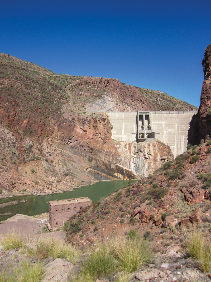
In less than 15 miles you will approach the north end of Theodore Roosevelt Lake, the largest lake in Arizona. Those long, grand, rugged azure mountains to the east are part of the Sierra Ancha range. On the other side of it lies Young, Arizona, site of the Pleasant Valley wars written about by Zane Grey. The lake is full of trout and bass but that’s another (fish) story altogether. Continue south and there are places to pull over at the impressive dam and arch bridge. Now, if you’re on that adventure bike and addicted to dirt, you can cut the loop short and head back to Apache Junction on State Route 88. Arizona has the audacity to call this a state route, but none of it is paved and parts make you want to really slow down and say “whoa horsey.”

State Route 88 to Tortilla Flats
That arrow above the bike takes you on State Route 88 to Tortilla Flats in what we call the East Valley (of Phoenix). It is unpaved and the state has the audacity to call it a state highway – but great for an adventure bike.

For the road riders, a few miles past the dam is the Tonto National Monument. If you have a pass for the National Park system, you can use it here or pay to see the cliff dwellings and visitor center. Farther south of the lake a few miles is Boston’s Lake House Grill. It’s good for a sandwich and there’s a country store and gas there as well. This whole loop is less than 180 miles, but if it is all new, you just might find yourself stopping so often that it takes a lot longer than usual.

The old steel bridge crosses the Salt River where it fills Lake Roosevelt
The old steel bridge crosses the Salt River where it fills Lake Roosevelt, the linchpin of the five-lake watershed. Cross that bridge and you can travel to Young, Arizona. I just love the 100-year-old steel bridges but they keep tearing them down as fast as they can.

Continue another 30 miles or so to the Globe/Miami junction, meeting U.S. 60. If it’s time to put on the feedbag, there’s an old-time Mexican restaurant, Guayo’s On The Trail, on the left before you get there, or Judy’s Cookhouse is at the intersection where you turn right on U.S. 60. The good ol’ boys and locals go to both, but gourmet dining is unknown in Gila County.

The last westbound segment of the loop runs about 55 miles back to the East Valley. You’ll pass the entrance to the Renaissance Festival, which takes place in March. It’s a great venue to watch guys wearing armor get knocked off their horses with a lance–if watching medieval violence and munching on deep fried turkey legs is your entertainment preference.

Steel bridge over the Salt River
A close-up look of the old bridge over the Salt River. Most of the road to Young is also unpaved, but an easy ride for an adventure bike. The vistas are unparalleled.

U.S. 60 was one of the few roads to Phoenix before freeways and goes through rugged, spectacular, boulder-strewn mountains and canyons. Most of the road hasn’t changed much in 70 years, until you get closer to the valley. This is copper mining country. Putting a four-lane road through here would cost a mighty sum and rural Arizona is poor, so the road just winds its way as best it can. There are some passing lanes if you get stuck behind slow traffic.

If you had a good ride on this loop, there’s more to enjoy in Arizona in winter. I don’t get tired of it and am thanking my lucky stars to have such a pretty place to ride any time of year.

Source: RiderMagazine.com

Favorite Ride: Washington’s Glacier-Fed Jewel

Washington state motorcycle ride
Weaving ridiculously close to Lake Chelan’s western shore at times, State Route 971 serves travelers up a scenic platter of lakefront views. Photos by the author.

When the need arises for a quick, fun jaunt that includes great food, I point my front wheel north through a landscape that at times appears to be from another world, or at least another time on this planet some tens of thousands of years ago. My mid-ride target is to meet my niece Karen and her fiancé Buddy, then proceed to his restaurant in Manson, Washington. Karen owns a salon in neighboring Chelan, so for both of them the busy summer is their bread and butter but they still make time to join old U.B. (Uncle Ben) for a portion of the ride.

Washington state motorcycle ride
Map of the route taken, by Bill Tipton/compartmaps.com.

Starting my loop out of Ephrata, the main north tributary out of town that becomes Sagebrush Flats Road should be cautiously approached…it goes right by the county jail! Just a mile later one can exercise the throttle through rolling fields and abundant sagebrush amid very solitary conditions. This is a pleasant respite from the crowds and traffic that must be endured later through the beautiful areas around Lake Chelan.

With nothing too technical, the “Flats” roll and buck like some of the horses you will pass in their corrals, then crossing a county line it changes name and personality to Coulee Meadows/Moses Coulee Road. More fun; a bit bumpy with a few giddy elevation changes and blind corners making for mildly challenging entertainment. Along this stretch one really begins to experience the terrain, channeled scablands of volcanic basalt and massive cliffs and mesas formed eons ago by continent-wide ice age floods and shifting glaciers.

Washington state motorcycle ride
Near the top of McNeil Canyon Road, riders can catch a glimpse of the alpine calmness of Lake Chelan waiting in the valley below.

Soon you’re on U.S. Route 2, where a short romp through this desolate landscape is still impressive if you like wide-open spaces. Fittingly named Farmer on the map, it consists of only a grain elevator and old grange hall, but provides the only shade for miles around if you need a break from summer heat. More importantly it signals the turn north onto State Route 172, where if you enjoy the sensation of trying to escape earth’s gravitational pull there are a couple of hills that will not disappoint.

Soon you come upon the sign for Lake Chelan, an alpine jewel that in this flat, scabby plateau must make first timers think it is some sort of joke. This initial portion of McNeil Canyon Road teases riders, as it jitters and jigs with a few sharp nineties and chicanes that bring you to a precipice over the gorge. From this vantage one gets a glimpse of the lake below and of the glacial peaks that feed it.

Washington state motorcycle ride
With Lake Chelan as a crazy beautiful backdrop, the welcome to the eastside town of Manson frames our machines nicely.

After plunging like last year’s necklines, the terrestrial cleavage of McNeil deposits travelers onto U.S. Route 97 for a quick crossing of the Columbia via a very old steel trellis bridge, before throwing another fun twist at you as it augers up the Chelan Falls hill into town. This is part of State Route 150, and by following the signs you will end up riding casually (read: slowly) amidst summer fun-seekers through this tourist haven up Lake Chelan’s eastern shore to Manson.

Chelan is touted as the third-deepest lake in the United States–geological surveys record a depth of 1,486 feet, however some locals maintain the lake has no bottom in spots. At 55 miles long and 1 to 2 miles wide it is also considered one of the most pristine bodies of water in North America, with a high degree of clarity.

Washington state motorcycle ride
The best place to eat in Manson, with the proprietor Buddy and his fiancée, my niece Karen.

After a warm welcome at Buddy’s Place and a great lunch, it is time to backtrack to Chelan and work around the southern end to explore the western shore. The up-lake vista invigorates with smooth two-lane that follows the rocky shoreline on State Route 971. The roadside is full of expensive vacation properties and an increasing number of vineyards that ply their wares at tasting rooms and tapaterias. Once broken free of these clinging tendrils of urbanization, the road begins to rock and roll with a shoreline lined with deep green pines decorating steep hillsides and the occasional glimpse of brilliant white glaciers.

After 16 delightful miles we reach pavement’s end at Twenty-Five Mile Creek Campground, situated on a picturesque point that serves as a lovely rest stop. While carefully careening through the woods on the return leg of 10 miles, watch for the Lake Chelan State Park entrance and the rustic Watson’s Alpenhorn Café, where State Route 971 now beckons riders south. Also tagged Navarre Coulee, this fragrant, tree-lined “tunnel” contains sharp hairpins on each end of its nine miles, as if needed to hold its place in the earth’s coiffure. It almost too abruptly bursts out of the shade into a few tight switchbacks before dropping down to meet again with U.S. Route 97A. Once southbound for Entiat, for the next 30 miles you will begin to appreciate the amount of work it must have taken to blast this rugged path from the brown stone mountainsides.

Washington state motorcycle ride
Nearing the end of pavement at Lake Chelan’s halfway point, the views from Twenty-Five Mile Creek Park show alpine lake beauty even in summer.

The Columbia River, harnessed here both for power and irrigation, is your companion as you bend lazily past orchards neatly covering either side’s steep slopes. Segueing directly into the apple-growing outskirts of Wenatchee you follow the signs back to U.S. 2 via the concrete bridge spanning the Columbia. Flowing faster than the river you pass through East Wenatchee along Sunset Highway/U.S. 2/State Route 28 all rolled into one, and eventually rejoin Route 28 heading out of town and back into time.

At least that is what it seems like to me after making the turn north onto Palisades Road. Entering a green, well-irrigated valley surrounded by more of this region’s steep volcanic basalt cliffs, it feels like I am in 1969’s blockbuster film, “Valley of Gwangi.” In the creepy stillness of this gorge I would not be surprised to see a Claymation dinosaur pop its head out of a cave.

Washington state motorcycle ride
The scenery surrounding you on Palisades Road will make you wonder if you should be riding a horse and carrying a six-shooter instead of a motorcycle and cell phone.

Ambling deeper and deeper between emerald colored fields and dusty ranchettes, my mental channel changes and I can just see “The Duke” John Wayne riding up on his horse yelling at me to take cover from the bandits in the cliffs! Oh imagination…fun until the pavement ends, and then that requires most of one’s attention. Though the twisting Devil’s Gulch portion that reconnects us to Sagebrush Flats back to Ephrata has about eight miles of dirt, it is quite navigable and hopes are that soon it will be covered in asphalt.

Whether out for a half day ride to see your “Buddy,” or dinosaurs or The Duke…our favorite rides hold familiarity and yet with each new one, a realm of new experiences and possibilities.

Source: RiderMagazine.com

Favorite Ride: Melodic Montana

Montana motorcycle ride
Riding in Montana is big: big skies, big trees, big rivers and big fun. Photos by the author.

It’s with a nod to the late, great music show host Lawrence Welk that I start this ride spanning a couple of Montana’s scenic blue highways. The bandleader’s famously accented musical lead-in is doubly relevant for this trek. First, this ride will begin and end with music. Second, it will encompass rolling on Montana’s historic Highways 1 and 2. So, without further ado, “Ah one, an’ ah two….”

Montana motorcycle ride
Map of the route taken, by Bill Tipton/compartmaps.com.

Rockin’ the Rivers and Rollin’ on Highway 2

While it is most certainly true that it’s “about the ride not the destination,” having something entertaining to do before and after a ride adds spice to the adventure. With that in mind, my trek starts at the Rockin’ the Rivers Music Festival near Three Forks, Montana. It is not an accident that I found this event in my ride planning as it sits directly on the first of the routes that attracted me to the area. So as I sit listening to the classic rock of the Grass Roots and then Tommy James and the Shondells, my mind wanders to Montana State Highway 2.

Montana motorcycle ride
The Grass Roots echo in the grasslands at the Rockin’ the Rivers Music Festival.

As I leave the festival, my ride on Highway 2 leads me almost immediately to the entrance of the Lewis and Clark Caverns State Park. While I decide not to do any spelunking, I stop long enough to read about the caverns and the fact that the Lewis and Clark expedition camped very close to the cave.

Rolling out of the park, the riding fun begins. The 20-mile stretch of Highway 2 that leads to my night’s lodging in Whitehall, Montana, is a great series of curves that follows the Little Pipestone Creek through an impressive river canyon. It is a nice precursor to what I will experience the rest of this ride.

Montana motorcycle ride
This ride is dotted with historical sites, many of which document the Lewis and Clark expedition.

After a night’s sleep, I gas up in Whitehall and head northwest on the remainder of Highway 2. I roll past farms and ranches through big, sweeping curves. As I continue north, the grasslands morph into high chaparral. The road tightens into some entertaining hairpins as I gain elevation into a pine forested stretch. This is clearly great three-season motorcycle country.

Montana motorcycle ride
The motorcycles in Montana are as diverse as the music.

Ultimately, this pine forest gives way to rich grasslands as I approach the historic mining town of Butte. Before grabbing lunch in a local diner, I ride through Butte’s well-preserved historic district. Amazingly, there are more than 10,000 miles of abandoned mine shafts and tunnels beneath the city. The wealth attained in those mines earned Butte the moniker “The Richest Hill on Earth.”

Montana motorcycle ride
Rivers like the Little Blackfoot make the area around Missoula a fly fishing paradise.

Carving Highway 1 to a Jam in Missoula

A short stretch on Interstate 90 after Butte leads me to the exit for Montana State Highway 1. Signs tell me that Highway 1 is also known as the Pintler Veterans Memorial Scenic Highway and it certainly lives up to that “scenic” designation.

The first thing that catches my eye as I head west on the highway is a huge smokestack in the distance. It turns out that smelter stack is the most notable landmark in the town of Anaconda. It also turns out that the town’s name is prophetic. After leaving Anaconda, the road begins to coil into a serpentine motorcycle playground.

Montana motorcycle ride
The road west of Anaconda clings resolutely to spectacular crimson canyon walls.

As I climb into the Anaconda-Pintler Mountain Range on Highway 1, I stop at several interesting historic sites. Montana does a great job of providing well-written and informative signage for its historic markers. Just as Lewis and Clark’s exploration is well-documented on the route, significant mining windfalls are also highlighted.

Montana motorcycle ride
The author does a bit of map study beside yet another interesting historical marker.

I stop beside the deep blue waters of Silver and Georgetown lakes, which spell the approximate midpoint of this ride on the scenic route. After the lakes, the road coils again as it passes through pines, grasslands and crimson canyons. It’s a very entertaining ride indeed, and the number of motorcycles I meet on the road indicates it is not a secret to riders.

Montana motorcycle ride
Blue waters and blue sky converge at Montana’s high-mountain Silver Lake.

The Pintler Veterans Memorial Scenic Highway ends at Interstate 90. However, I have found that it can pay off in spades to travel frontage roads rather than the nearby interstate. The long frontage road on this stretch of I-90 to Missoula is just such a find. The beautiful tree-lined Clark Fork River separates the interstate from the frontage road, making it seem worlds away. Like so many of the rivers in the area, the Clark Fork makes me think of Norman Maclean’s Montana-set literary masterpiece, “A River Runs Through It.”

Montana motorcycle ride
This frontage road is a nice alternative to riding on the interstate south of Missoula.

When the fun of the I-90 frontage roads ends, there is just a short stretch of the interstate that leads to Missoula. Like Butte, Missoula is a town worth an extended visit. The historic city has a bustling charm that is enhanced by the vibrancy infused by the University of Montana.

Montana motorcycle ride
Pearl Jam rocks the beautiful University of Montana football stadium in Missoula.

As I sit in the beautiful Montana Grizzly Stadium listening to Pearl Jam and watching the sun set on the rolling hills just past the stage, I can’t help but reflect on a great ride. To steal a few song titles from the band, the “Even Flow” of the ride certainly made me feel “Alive.” Or, as Mr. Welk might say, this Montana tour was “wunnerful, wunnerful.”

Source: RiderMagazine.com

The Old Way: Historic U.S. 80 and the Wood Plank Road

Plank Road
Travel from Yuma to San Diego via historic U.S. Route 80 and the wood Plank Road, and you’ll see how unforgiving the desert can be. Photos by the author.

Picture a scene in which hearty travelers traverse barren and windswept sand dunes on roads of rough-hewn timbers. I am not talking about some prehistoric time nor am I forecasting a dystopian future. No, my friends, many still-living Americans could tell you of this strange and fascinating tale set in the American Southwest.

I recently happened upon a magazine article that mentioned a wood plank road that spanned the sand dunes linking the southernmost portions of California and Arizona. With my interest piqued, I dug deeper and discovered that the Old Plank Road was operational for more than a decade and was ultimately displaced by a paved portion of U.S. Route 80 in 1926.

Almost four decades later, U.S. 80 succumbed to Interstate 8. Now, the Plank Road is a fascinating, crumbling relic of the early 20th century; however, long portions of Historic U.S. 80 are still passable as an interesting alternative to I-8 from Yuma, Arizona, to San Diego, California.

That was enough for me. I dug deeper into the history of the Plank Road, researched Historic U.S. 80, charted my course and packed the bags on my BMW R 1200 GS. I was off to discover the Plank Road and ride as much of Historic U.S. Route 80 as possible from Yuma to San Diego.

Plank Road
The Ocean-to-Ocean Highway Bridge is the impressive opening act to the Yuma to San Diego trek. The bridge spans the Colorado River, and its 1915 completion date coincides with the Plank Road. Its name indicates its importance in the nationwide, transcontinental Ocean-to-Ocean Highway.

Yuma to El Centro – in Search of the Plank Road

The sun-drenched starting point of my ride was the history-rich city of Yuma, Arizona. Now snowbirds in massive RVs converge on the city in winter like their winged migratory counterparts. However, Yuma was once a centerpiece of the Old West, and has been a transportation hub of the Southwest for more than one hundred years.

I began my trek west at the Ocean-to-Ocean Highway Bridge, which spans the Colorado River in north Yuma. Now on the National Historical Register, the bridge was completed in 1915, which coincides with the early years of the Plank Road. The area directly surrounding the bridge is home to a cluster of historical sites. The Yuma Territorial Prison, which sits directly adjacent to the bridge, was an intriguing walk back into the rough-and-tumble Old West. The close-by Colorado River State Historic Park dates back to the late 19th century and preserves a small number of the Plank Road timbers in a display.

After riding over the Ocean-to-Ocean Highway Bridge, a quick left turn placed me immediately on Historic U.S. 80. The road took me by crumpling adobe structures, over the All-American Canal and through the sandy desert. Whereas nearby I-8 is smooth, wide and boring, Historic U.S. 80 is narrow, cracked, undulating and entertaining. It requires attention and a bit of slaloming to avoid jarring reminders that it is a historic route. The long suspension on the BMW was tailor-made for the unpredictable road conditions.

Plank Road
A ride on Historic U.S. 80 requires vigilance. Sand drifts, potholes and crumbling margins speak to its relegation to secondary status.

After this opening act of my Historic U.S. 80 tour, I rejoined I-8 for a bit. Portions of Historic U.S. 80 are relegated to spur status–they “spur” off of the interstate but terminate without rejoining the new route. One such spur is Grays Well Road.

The Grays Well section of the original route is now a well-paved ingress into the Imperial Sand Dunes portion of the larger geological feature known as the Algodones Dunes. These dunes are what made the Plank Road necessary in the early 1900s. After enjoying a short, beautiful ride through shining sand hills, I came to the site that contains the longest and best-preserved portion of the Old Plank Road.

What I found was a stretch of the Old Plank Road that spans the equivalent of about five football fields in length. The road is protected from potential damage by off-road vehicles with metal, sand-worthy barriers, but visitors can touch and walk the Plank Road section. The road is intriguing. It has weathered and rusted into a heaving work of art.

Plank Road
One can almost hear the rhythmic thumping of Model T tires when visiting the protected section of the wood Plank Road. The vast majority of nearby interstate travelers have no idea that this historic relic even exists.

So why was the timber road ever built? Quite simply, it was commercially important to have a direct route here from the growing and thriving San Diego coastal area to the west. While asphalt and concrete road building techniques of the time worked reasonably well on the harder surfaces of the area directly east of the coast, the shifting sands of the Algodones Dunes posed a huge quandary for road builders.

San Diego businessman Ed Fletcher was the driving force that ultimately led to the construction of the Plank Road. That bumpy, ever-changing, maintenance-intensive endeavor continued as the transportation solution for crossing more than six miles of the dunes from 1915 through 1926.

Plank RoadI walked, touched and studied the Plank Road in solitude. Not a single soul even drove by in the substantial time I spent in the surreal dunes. When I finally pulled myself away, I took another short ride on the interstate before jumping back on Historic U.S. 80 toward the California towns of Holtville and El Centro. The long, straight stretch of the historic road gave me time to ruminate on the Plank Road and the challenges of early travelers.

Much of Historic U.S. 80 runs parallel with and in close proximity to the interstate, but it is worlds apart in terms of traffic and fun. There are remnants and ruins of structures that were left to languish in the desert heat when traffic was rerouted to the newer and faster interstate.

Historic U.S. 80 runs through the hearts of both Holtville and El Centro, as both were supremely important to the commerce and trade of the time. Either of these cities can serve as a gas and food stop on this route; I found a hotel in El Centro just off the Historic U.S. 80 route.

Plank Road
The Cleveland National Forest spans 460,000 acres of desert and chaparral.

Ocotillo to Laguna Junction – on the Winding Road

While fascinating and historically rich, the prior day’s ride was, for the most part, straight. Motorcyclists, by nature, love curves and that is what this next leg of my ride on Historic U.S. 80 had to offer.

After a breakfast of huevos rancheros in El Centro, I made my way to Ocotillo. After rolling through the town, named after a type of cactus, I rode a nicely curvy stretch of I-8 until I came to the exit for the Desert View Tower. The tall, eclectic stone structure, which dates back to the time of the Plank Road, sits on another Historic U.S. 80 spur west of the interstate.

After a short visit to the tower, I crossed the interstate to the south onto a long, intact loop of Historic U.S. 80. The road is instantly winding and remains coiled for miles of highly entertaining riding. The little desert oasis town of Jacumba Hot Springs is home to its namesake spring, a few colorful buildings and a clothing-optional resort. I am sure to everyone’s delight I opted to stay clothed and keep riding.

Plank Road
The GS is right at home with several brethren outside the Jacumba Spa Restaurant.

At a few points along the route, the tall international border “wall” could be seen to the south and there were sporadic signs warning that the region is subject to illegal drug trafficking. However, from the rolling perspective of a motorcycle saddle, there is a slow-paced calm to the area.

I rode through several small clusters of humanity and miles of unspoiled nature toward the Campo Indian Reservation and the Cleveland National Forest. The road conditions are variable and there are sections of concrete as well as reasonably maintained asphalt. However, from a pure riding perspective, I found this to be the most entertaining stretch of the route.

Plank Road
The Jacumba section just north of the U.S./Mexico border is the most curvy and entertaining of the ride.

Laguna Junction to the Beautiful Balboa Park

At Laguna Junction, Historic U.S. 80 runs north of the interstate for a while as it winds to the west. I passed through the small towns of Guatay and Descanso Junction, and the increased elevation of 4,000 feet brought with it a nice mix of oak and pine trees. Where Historic U.S. 80 melds back into I-8, I could see several now impassable portions of the old road in the mountains to my right.

From this point on through Alpine, El Cajon and La Mesa, Historic U.S. 80 flirts with and becomes the interstate and other roads intermittently. The ride in this stretch was much more frenetic and filled with traffic than the rest of the route, and rolled through historic commercial districts and residential communities as the ride became increasingly urban.

Plank Road
The entrance of the stunning Balboa Park is an impressive foreshadowing of the treasures within.

After several miles of this suburban jockeying, I rolled to the end of my tour as I entered the stunningly beautiful Balboa Park. The “Jewel of San Diego” spells the approximate end of the Historic U.S. 80, and a perfect end to the ride. The lush natural environment combined with fantastic museums and entertainment venues like the Old Globe Theater make Balboa one of the most delightful parks in the Southwest.

My final stop was the San Diego Automotive Museum in Balboa Park, which houses a nice collection of historic motorcycles alongside vintage and unique cars and trucks. Fittingly, the museum features a creative display dedicated to the Old Plank Road, which brings it to life and provides a fine overview of this significant part of transportation history.

Plank Road
The San Diego Automotive Museum in Balboa Park features a current exhibition that brings the Plank Road to life.
Plank Road
Historic photos and staged exhibits in the museum show the wonders and challenges of crossing the Imperial Dunes.

Riding Considerations

Being a desert region, this ride is best made from fall to spring. The summer months are sweltering. Road conditions are extremely variable as there are sections of both asphalt and concrete. Potholes, sand and some broken tarmac should be expected. For a detailed series of route maps, visit americanroads.us/ushighways/ushighway80.html.

Source: RiderMagazine.com